Mori Atlas logo
Nature reserveKelzer Teiche

Examining the ecological boundaries and landscape features of this historic wetland refuge in central Germany.

Kelzer Teiche Nature Reserve: A Detailed Geographic Overview of Protected Ponds in Northern Hesse

(Naturschutzgebiet Kelzer Teiche)

Kelzer Teiche stands as a significant protected nature reserve within the agricultural landscape of northern Hesse. This geographic entity centers on the Oberer and Unterer Kelzer Teiche, two historic fishponds managed to support diverse waterbirds and migratory species. The surrounding terrain incorporates extensive reed beds, riparian woodland, and grassland, creating a complex wetland mosaic that serves as a vital refuge in the Kassel region.

fishpondsreed bedswetlandwaterbirdsmigratory birdsnature reserve

Kelzer Teiche

Nature reserve

Park overview

Structured park overview, official facts, and landscape profile for Kelzer Teiche

Kelzer Teiche park facts, protected area profile, and essential visitor context

Review the core facts for Kelzer Teiche, including designation, size, terrain, visitor scale, habitats, and operating context in one park-focused overview.

About Kelzer Teiche

Kelzer Teiche is a compact but ecologically distinctive nature reserve in northern Hesse, representing the kind of cultural fishpond landscape that has shaped parts of the German countryside for centuries. The reserve protects two ponds, the Oberer Kelzer Teich and the Unterer Kelzer Teich, which were originally created as fishponds. A small connecting brook links the two water bodies and eventually drains into the Esse, itself a tributary of the Diemel river. In winter the pond water is deliberately drawn down, a traditional method used to manage fishpond ecosystems and to keep the shallow-water and shoreline conditions favorable for wildlife.

The site sits in open agricultural land between Hofgeismar and Grebenstein, in the rolling lowlands northwest of Kassel. Within this largely cultivated setting, the reserve forms a clearly defined patch of wetland habitat. Its ponds are fringed by broad reed (Schilfröhricht) zones, beyond which stretches of natural woodland and scrub (Gehölzbestände) provide nesting cover and shelter. The remaining open areas of the reserve are made up of grassland, completing a mosaic of water, reed, wood, and meadow typical of well-managed pond complexes in the region.

Although small in absolute size, Kelzer Teiche occupies an important niche in the local conservation landscape. Its combination of open water, dense reed margins, and adjacent woody vegetation makes it a focal point for waterbirds and marsh-dwelling birds, and the seasonal draining of the ponds creates periodically exposed mudflats that are attractive to feeding and resting wildlife. Together with neighbouring protected ponds, brook valleys, and forest remnants in the Landkreis Kassel, Kelzer Teiche contributes to a wider network of habitats supporting the region's biodiversity.

Quick facts and research context for Kelzer Teiche

Kelzer Teiche is a designated nature reserve (Naturschutzgebiet) in Hesse, northern Germany, registered under area number 1633005 and recognized in the World Database on Protected Areas as WDPA ID 82054. It lies between the towns of Hofgeismar and Grebenstein in the Landkreis Kassel, just northwest of the city of Kassel, and covers about 18.5 hectares of agricultural countryside shaped around two interconnected fishponds and their surrounding reed, woodland, and grassland habitats. The reserve has been under formal protection since 23 May 1977, expanding an earlier 1938 protection of the Oberer Kelzer Teich.

Protection and recognition

Explore documented conservation measures and administrative records for Kelzer Teiche.

Kelzer Teiche Protection Status and Official International Recognition Data

Examine the verified protection status and official database records associated with Kelzer Teiche. Review the foundational conservation metrics and administrative identifiers compiled for this protected area.

Protection details

WDPA ID
82054
Park context

Deeper park guide and search-rich context for Kelzer Teiche

Kelzer Teiche history, landscape, wildlife, and travel context

Explore Kelzer Teiche through its history, landscape character, ecosystems, wildlife, conservation priorities, cultural context, and seasonal travel timing in a structured park guide built for atlas discovery and search intent.

Why Kelzer Teiche stands out

Kelzer Teiche is best known for its two historically managed fishponds, the Oberer Kelzer Teich and the Unterer Kelzer Teich, and the extensive reed beds and fringing woodland that surround them. The reserve is particularly valued for waterbirds, reed-nesting bird species, and its role as a stopover and resting area for migratory birds passing through northern Hesse.
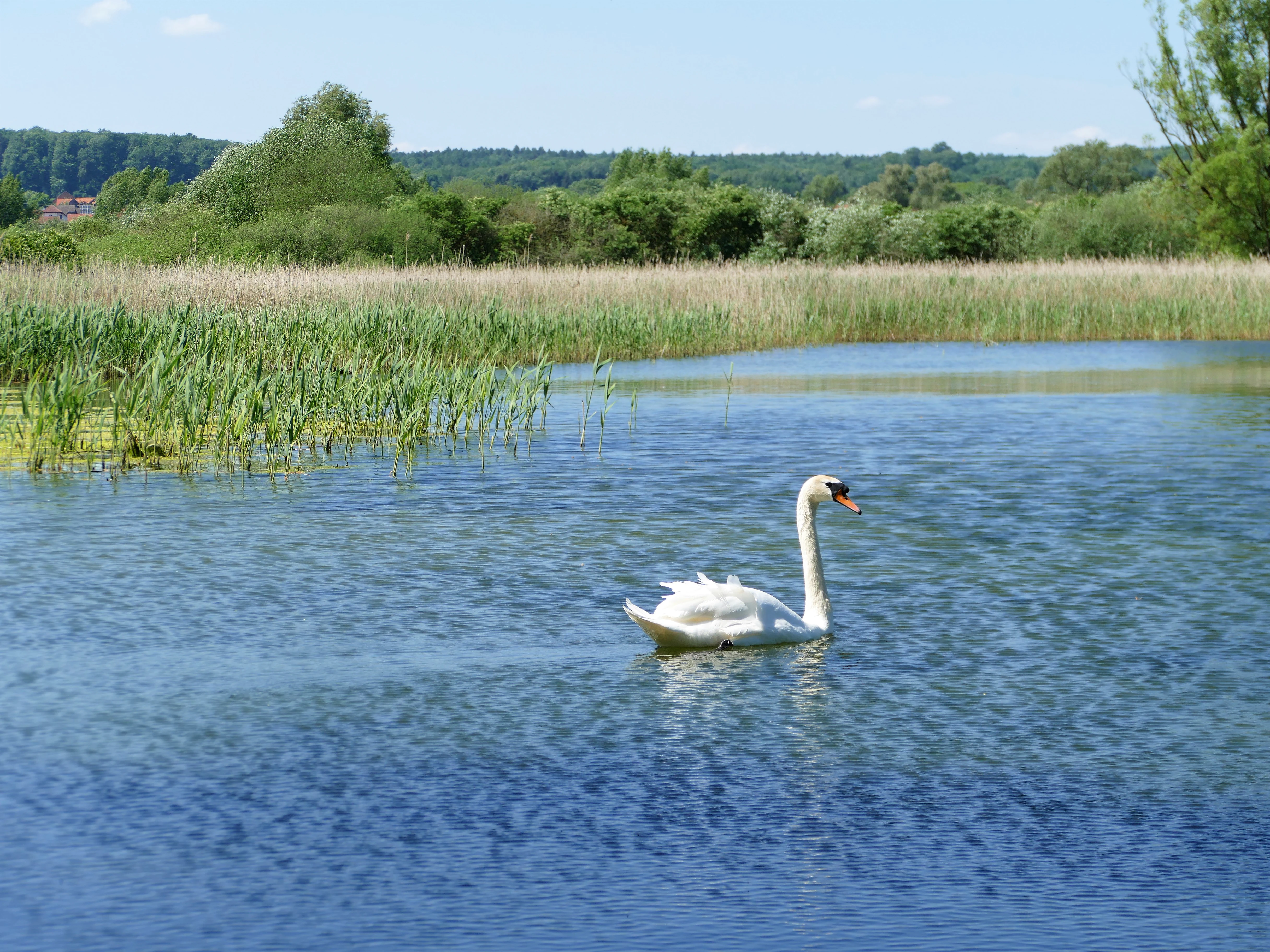
A white swan swimming on a pond with a shoreline of tall reeds and green trees in the background.
A mute swan swimming on the waters of the Kelzer Teiche nature reserve.

Kelzer Teiche history and protected-area timeline

The protection history of Kelzer Teiche begins with the establishment of a smaller protected area around the Oberer Kelzer Teich in 1938. Decades later, on 23 May 1977, the modern Naturschutzgebiet Kelzer Teiche was formally designated under area number 1633005. At that time the earlier 1938 reserve was incorporated into the larger, expanded protection area, consolidating the Oberer and Unterer Kelzer Teich and their associated land into a single, more coherent nature reserve. Since then the site has remained part of the network of Naturschutzgebiete in the Landkreis Kassel, recognized internationally through the World Database on Protected Areas under ID 82054.

Kelzer Teiche landscape and geographic character

The landscape of Kelzer Teiche is shaped by the gentle, low-lying agricultural countryside of northern Hesse, where cultivated fields, small streams, and historic fishponds interleave. At the heart of the reserve are the two ponds, the Oberer Kelzer Teich and the Unterer Kelzer Teich, set in a shallow basin and joined by a small brook that ultimately flows into the Esse, a tributary of the Diemel. These water bodies are not wild lakes but artificial fishponds, and their outlines reflect centuries of human management of the rural landscape.

Around the ponds, broad belts of reed (Schilfröhricht) form a soft, marshy margin, grading into thicker stands of trees and shrubs that create a wooded buffer between the open water and the surrounding farmland. Beyond these wooded fringes, the reserve continues into patches of grassland, contributing additional structural variety to the protected area. The wider setting is dominated by agricultural land, and the reserve is bounded by transport and rural routes: the Bundesstraße 83 lies along its northeastern side, and Kreisstraße 59 marks part of its northern edge, while a Wirtschaftsweg (agricultural service road) runs along its southern boundary.

Kelzer Teiche ecosystems, habitats, and plant life

Kelzer Teiche illustrates the ecological value of cultural fishpond landscapes, where traditional pond management and natural ecological processes combine to produce rich habitats. The two ponds, together with the connecting brook and the broader floodplain influence of the Esse, create a wetland mosaic of open water, shallow margins, reed beds, scrub, woodland, and grassland. This range of habitats within a compact area supports a variety of ecological niches throughout the year.

The seasonal drawdown of pond water in winter is a defining feature of the site's ecology, exposing muddy pond beds and shorelines that are quickly colonized by plants and invertebrates typical of managed fishpond systems. Reed zones dominate the immediate waterside, providing habitat for species that depend on tall emergent vegetation, while the adjoining tree and shrub stands offer nesting sites, shelter, and perches. Grassland pockets round out the habitat structure, ensuring that the reserve is not solely a wetland but a layered mosaic of semi-natural habitats embedded in the agricultural matrix of northern Hesse.

Kelzer Teiche wildlife and species highlights

Kelzer Teiche is recognized principally for its birdlife, especially the species associated with open water, reed beds, and seasonal movement. The combination of two ponds, expansive reed margins, and surrounding woody cover makes the reserve an attractive site for waterbirds, which use the open water and the muddy shorelines exposed after the winter drawdown for feeding and resting. Reed-dwelling bird species are likewise well served by the tall, dense Schilfröhricht that lines much of the shoreline, where marsh-nesting species can find cover and breeding habitat.

Beyond these resident and breeding groups, the reserve has particular importance as a resting and staging area for migratory birds moving through northern Hesse. The ponds and fringing habitats provide a stopover where birds can replenish energy reserves, while the mix of water, reed, scrub, and woodland offers a variety of feeding and shelter conditions in a small area. While the ponds themselves are modest in size, their habitat diversity and management regime give the reserve a disproportionately rich birdlife profile compared with the surrounding agricultural land.

Kelzer Teiche conservation status and protection priorities

The conservation significance of Kelzer Teiche lies in the protection and careful stewardship of a classic cultural fishpond landscape in northern Hesse. As a designated Naturschutzgebiet, the reserve secures about 18.5 hectares of ponds, reed beds, fringing woodland, and grassland, ensuring that these habitats are preserved in a region otherwise dominated by agriculture and road infrastructure.

The site's value is closely tied to traditional pond management, including the seasonal draining of the ponds in winter, which maintains the dynamic, shallow-water conditions that support characteristic wetland biodiversity. By protecting both the aquatic and terrestrial components of the system, the reserve conserves the ecological interconnections between open water, reed, woodland, and meadow. Inclusion in the World Database on Protected Areas under ID 82054 also places the site within the broader international framework of protected-area recognition, while its position among neighbouring reserves in the Landkreis Kassel adds to the cumulatively important network of wetland and forest habitats in the district.

Top sights and standout views in Kelzer Teiche

The defining highlights of Kelzer Teiche are its two historic fishponds, the Oberer Kelzer Teich and the Unterer Kelzer Teich, and the way they are integrated into a working agricultural landscape. The reserve stands out for its wide zones of reed, its adjoining stands of trees and shrubs, and the small but ecologically rich mix of habitat types that support waterbirds, reed-specialist bird species, and migratory birds in northern Hesse.

Best time to visit Kelzer Teiche

Because Kelzer Teiche is a small nature reserve whose character is shaped by the seasonal management of its ponds, the time of year strongly influences what a visitor experiences. The ponds are drained in the winter months, exposing muddy shorelines and creating shallow, changing conditions that are particularly attractive to waterbirds and to watchers interested in seasonal dynamics. Spring and early summer, by contrast, bring the most lush reed growth and active bird presence along the pond margins, while autumn sees migratory birds using the area as a stopover site in the broader regional movement corridor.

Monthly climate preview

Long-term representative monthly temperature and precipitation data for Hesse

Kelzer Teiche Climate Normals and Measured Annual Temperature Patterns

Representative coordinate records show measured monthly temperature variations alongside steady precipitation rates throughout the year at Kelzer Teiche. Examining the complete monthly climate normals profile provides detailed long-term averages for multi-season geographic comparison.
Annual mean8 °C
-1 °C18 °C
Jan-1°
Feb
Mar
Apr
May12°
Jun16°
Jul18°
Aug18°
Sep14°
Oct
Nov
Dec
Warmest month
July

18 °C

Coolest month
January

-0.6 °C

Wettest month
July

2.5 mm/day

Driest month
April

1.5 mm/day

Park location guide

Geography guide, regional context, and park location map for Kelzer Teiche

Kelzer Teiche park geography, regions, and map view in Germany

Understand where Kelzer Teiche sits in Germany through a broader geographic reading of the surrounding landscape, nearby location context, and its mapped position within the national park landscape.

How Kelzer Teiche fits into Germany

Germany is a federal republic in Western and Central Europe with a population of over 83 million across sixteen constituent states. It is Europe's largest economy by nominal GDP and a major global exporter and importer. The capital is Berlin, and the country borders Denmark, Poland, Czech Republic, Austria, Switzerland, France, Luxembourg, Belgium, and the Netherlands.

Wider geography shaping Kelzer Teiche in Germany

Germany is located in Western and Central Europe, spanning 357,022 km². It borders Denmark to the north, Poland and the Czech Republic to the east, Austria and Switzerland to the south, and France, Luxembourg, Belgium, and the Netherlands to the west. The country has coastlines on the Baltic Sea and North Sea to the north, with the Alps located in the southern region.

Map view of Kelzer Teiche

Use this park location map to pinpoint Kelzer Teiche in Germany, understand its exact geographic position, and read its mapped placement within the surrounding landscape more clearly.

Pigeon | © OpenStreetMap contributors

Location context for Kelzer Teiche

Hesse

Visualizing the historic fishponds, reed beds, and wetland habitats of northern Hesse

Kelzer Teiche Photos and Protected Landscape Scenery

Examine detailed photographs of the open water, marshy margins, and wooded buffer zones defining Kelzer Teiche. Visual records illustrate the unique terrain and seasonal management characters shaping this protected wetland sanctuary.

A white swan swimming on a pond with a shoreline of tall reeds and green trees in the background.

Park atlas

Discover adjacent nature reserves and regional wetland landscapes across northern Hesse

Explore Protected Areas and Parks Near Kelzer Teiche

Compare Kelzer Teiche with other protected areas and wetland reserves located throughout the surrounding region. Broaden your geographic exploration by examining connected lowland habitats and regional park networks.
A soft watercolor painting of rolling green and yellow hills under a clear sky, featuring sparse shrubbery and a gentle, layered horizon.
Nature reserveHessen
About 2.8 km away#1 closest

Northwest

Mittelberg bei Hofgeismar: Nature Reserve and Protected Calcareous Grassland Site

A high-quality conservation landscape located in northern Hessen, Germany.

This nature reserve protects an ecologically rich slope habitat west of Hofgeismar. Defined by its sun-exposed calcareous soil and dry grassland, the site supports ten orchid species and a diverse assemblage of Red List butterflies. It stands as a textbook example of a small, high-density biodiversity hotspot embedded within the broader agricultural geography of the Kassel district.

Area
0.432 km²
Established
1991
Relief
Upland
Climate
Temperate
A watercolor painting showing a soft, panoramic view of rolling green hills, lush vegetation, and water, with a light and airy artistic style.
Nature reserveHesse
About 3.4 km away#2 closest

West

Meßhagen bei Niedermeiser Nature Reserve: Protected Landscape and Regional Geography

A mapped conservation site in the woodlands of Northern Hesse

Meßhagen bei Niedermeiser represents a key nature reserve in Northern Hesse, characterized by its transition between old beech forest and managed calcareous grasslands. This protected area, part of the wider Kelzer Holz network, provides a study in managed habitat succession, where meadow flora and invertebrate populations thrive in the intersection of open terrain and dense woodland edges.

Area
0.546 km²
Established
1996
Relief
Upland
Climate
Temperate
Watercolor painting of a calm wetland landscape with soft green trees along the water edge under a light, misty sky.
Nature reserveHessen
About 5.2 km away#3 closest

Southeast

Rothenberg bei Burguffeln Protected Wetland Landscape and Nature Reserve in Hessen

A specialized pond and meadow mosaic in the Hessian lowlands

Rothenberg bei Burguffeln preserves a vital wetland complex near Immenhausen, structured across three distinct sections, including the Rothenküler Teich and Tonkaule. The area represents a significant example of culturally shaped lowland geography, blending historic aquaculture with contemporary habitat management. Its protected status reflects a commitment to maintaining intricate riparian corridors and meadow ecosystems within the wider Hessian countryside.

Area
0.278 km²
Established
1983
A watercolor painting showing a rolling landscape with sparse trees on the left, a grassy slope rising to a small forest on the right, and distant hills under a pale, soft sky.
Nature reserveLandkreis Kassel
About 5.8 km away#4 closest

Northwest

Ostheimer Hute Nature Reserve: Protected Calcareous Grassland Landscapes in Landkreis Kassel

A preserved limestone slope habitat in northern Hesse

Ostheimer Hute is a protected nature reserve characterized by species-rich calcareous dry grasslands on Triassic Muschelkalk limestone. Located within the Diemel Valley, this site preserves a traditional open landscape through managed grazing, supporting diverse invertebrate fauna and specialized flora across its distinct hill-slope parcels.

Area
0.162 km²
Established
1989
Relief
Upland
Climate
Temperate
A soft watercolor illustration showing rolling green hills, distant mountains, and forested slopes on a white background.
Nature reserveHesse
About 6.7 km away#5 closest

North

Dingel und Eberschützer Klippen: Protected Landscapes and Geography in Hesse, Germany

A dense mosaic of limestone slopes, juniper scrub, and beech forest communities.

Discover the geographic identity of Dingel und Eberschützer Klippen, a combined nature reserve and Natura 2000 site in northern Hesse. The protected area features a unique concentration of orchid-rich habitats, south-facing limestone slopes, and broadleaf forest blocks that define this essential part of the Reinhardswald region.

Area
1.123 km²
Established
1987
Relief
Upland
Climate
Temperate
A soft watercolor painting showing a winding river flowing through a green meadow with rolling hills and distant forested ridges under a pale, warm sky.
Nature reserveLandkreis Kassel
About 6.7 km away#6 closest

Northwest

Kalkmagerrasen und Diemelaltwasser bei Lamerden Nature Reserve and Landscape Overview

A rare protected mosaic in the Landkreis Kassel district

Investigate the distinctive geography of Kalkmagerrasen und Diemelaltwasser bei Lamerden, where shell limestone slopes rise above the Diemel river oxbow. This protected habitat complex serves as an important ecological anchor in northern Germany, preserving the delicate balance between riparian flood zones and orchid-rich calcareous grasslands that define this regional landscape.

Area
0.175 km²
Established
1989
Relief
Upland
Climate
Temperate
A soft watercolor illustration showing rolling green hills, small groups of conifer trees, and a pale pink and peach sky in the background.
Natural monumentEberschütz
About 8 km away#7 closest

Northwest

Der Bunte Berg bei Eberschütz: Natural Monument and Landscape Geography

Limestone ridge and calcareous grassland habitat in Germany

Examine the topography and protected land features of Der Bunte Berg bei Eberschütz. This compact reserve provides a critical study of limestone-influenced terrain, transitioning from mature pine and beech woodland to specialized juniper heath and dry grassland habitats essential for regional biodiversity.

A soft watercolor illustration of a winding stream flowing through a green meadow with rolling hills in the background and a small cluster of pine trees in the foreground.
Nature reserveHessen
About 8.3 km away#8 closest

South

Jungfernbach und Brandteich bei Calden: Protected Forest and Stream Valley Geography

Regional nature reserve landscape located in northern Hessen

Examine the mapped boundaries and natural terrain of Jungfernbach und Brandteich bei Calden. This nature reserve offers a detailed look at lowland stream corridors, pond ecosystems, and riparian forest patches nestled within the rolling landscape of northern Hessen, reflecting the region's diverse protected land character.

Area
0.343 km²
Established
1985

Common questions about visiting, size, designation, and location context for Kelzer Teiche

Kelzer Teiche FAQs for park facts, access, geography, and protected area context

Find quick answers about Kelzer Teiche, including protected-area facts, park geography, trail and visitor context, and how the park fits into its surrounding country and regional landscape.
MoriAtlas Explorer

Continue Your Protected Areas Search Across the Global Atlas

Deepen your exploration by continuing the structured search for national parks and protected areas worldwide. Utilize the comprehensive filtering capabilities to compare different conservation landscapes and refine your understanding of global park geography. Discover more about the distribution and characteristics of protected natural areas.

Global natural geography