
Mori Atlas logo
Nature reserveKgaswane Mountain Reserve

Tracing the mountain veld, woodland, and wetland geography of this significant South African reserve.

Kgaswane Mountain Reserve: A Protected Landscape in the Magaliesberg Mountains of North West

Kgaswane Mountain Reserve encompasses 53 square kilometres of protected terrain on the northern slopes of the ancient Magaliesberg range. This geographically complex area integrates steep quartzitic ridges with open grasslands, mixed woodlands, and wetland systems recognized for their conservation importance. Map the varied topography and ecological diversity that define this essential protected area in the North West province.

Mountain reserveMagaliesbergBiosphere reserveRamsar siteBirdwatchingCape vultures
A graphic illustration in warm tones showing a vertical waterfall plunging from a high cliff edge into a winding river below with scattered trees and soft clouds under a setting sun.

Kgaswane Mountain Reserve

Nature reserve

Park overview

Structured park overview, official facts, and landscape profile for Kgaswane Mountain Reserve

Kgaswane Mountain Reserve park facts, protected area profile, and essential visitor context

Review the core facts for Kgaswane Mountain Reserve, including designation, size, terrain, visitor scale, habitats, and operating context in one park-focused overview.

About Kgaswane Mountain Reserve

Kgaswane Mountain Reserve occupies a striking position within one of southern Africa's oldest and most ecologically layered mountain systems. The Magaliesberg, which forms the reserve's southern boundary, runs roughly east to west through North West Province and Gauteng, and its northern slopes shelter a transition zone between Highveld grassland and bushveld vegetation patterns. The reserve therefore combines upland terrain with rock-strewn ridges, wooded valleys, and lower-lying mixed landscapes that together support an unusually high density of animal and plant species.

The protected area spans grasslands, scrub, mixed woodland, and patches of fynbos, and is noted for supporting roughly 115 tree and bush species, including plants considered rare in the region. The wildlife profile is correspondingly varied. Antelope dominate the larger mammals, with over 800 antelope reported across the reserve and a species list that includes klipspringer, grey duiker, bushbuck, kudu, oribi, mountain reedbuck, impala, red hartebeest, zebra, springbok, steenbok, sable antelope, and waterbuck. Predators are present in smaller numbers and include caracal, aardwolf, jackal, and leopard, giving the reserve a more complete ecological character than many similarly sized protected areas.

For birdwatchers, Kgaswane is arguably its most distinctive asset. Around 320 bird species have been recorded, and the reserve's cliffs and ridges provide breeding habitat for Cape vultures alongside martial and Verreaux's eagles. While larger game viewing and bird-focused visits tend to be the main attractions, the reserve also offers picnicking and braai sites connected by tarred roads, a visitor centre, a cottage, a group camp, and 22 camping sites. Four hiking trails, ranging from short interpretive routes to multi-day overnight hikes, allow visitors to experience different aspects of the terrain, from gentle wetland-edge birding routes to steep rocky climbs and routes that pass natural swimming pools and waterfalls.

Quick facts and research context for Kgaswane Mountain Reserve

Kgaswane Mountain Reserve is a 53 square kilometre nature reserve situated on the northern slopes of the Magaliesberg, about 5 kilometres south-west of Rustenburg in South Africa's North West Province. It forms part of the Magaliesberg Biosphere Reserve, sits alongside the Magaliesberg Protected Natural Environment, and has been designated as a Ramsar wetland site since 2019.

The reserve began as a protected area in 1967 under the name Rustenburg Nature Reserve and was re-proclaimed as Kgaswane Mountain Reserve on 21 February 2017. It is operated by the North West Parks and Tourism Board and supports large and small mammals, approximately 320 recorded bird species, and a varied vegetation profile that includes rare plants.

Protection and recognition

Documented conservation status and Ramsar site recognition records

Kgaswane Mountain Reserve Protection Status and International Recognition Data

Kgaswane Mountain Reserve protection status brings together official international recognition records and documented management data. Ramsar site listings provide the primary framework for evaluating international conservation designations.
Park context

Deeper park guide and search-rich context for Kgaswane Mountain Reserve

Kgaswane Mountain Reserve history, landscape, wildlife, and travel context

Explore Kgaswane Mountain Reserve through its history, landscape character, ecosystems, wildlife, conservation priorities, cultural context, and seasonal travel timing in a structured park guide built for atlas discovery and search intent.

Why Kgaswane Mountain Reserve stands out

Kgaswane is best known for its position on the Magaliesberg and for its unusually rich wildlife profile for a relatively compact mountain reserve. Its raptor life is a defining feature, including a breeding colony of Cape vultures, martial eagles, and Verreaux's eagles, while the broader bird list of around 320 species ranks it among the more ornithologically significant reserves in the North West Province. Beyond its birdlife, the reserve is recognised for its mix of antelope species and predators in a veld-and-woodland setting, and for its formal designation as a Ramsar site. Together these qualities place Kgaswane among important protected natural areas in the Magaliesberg region.
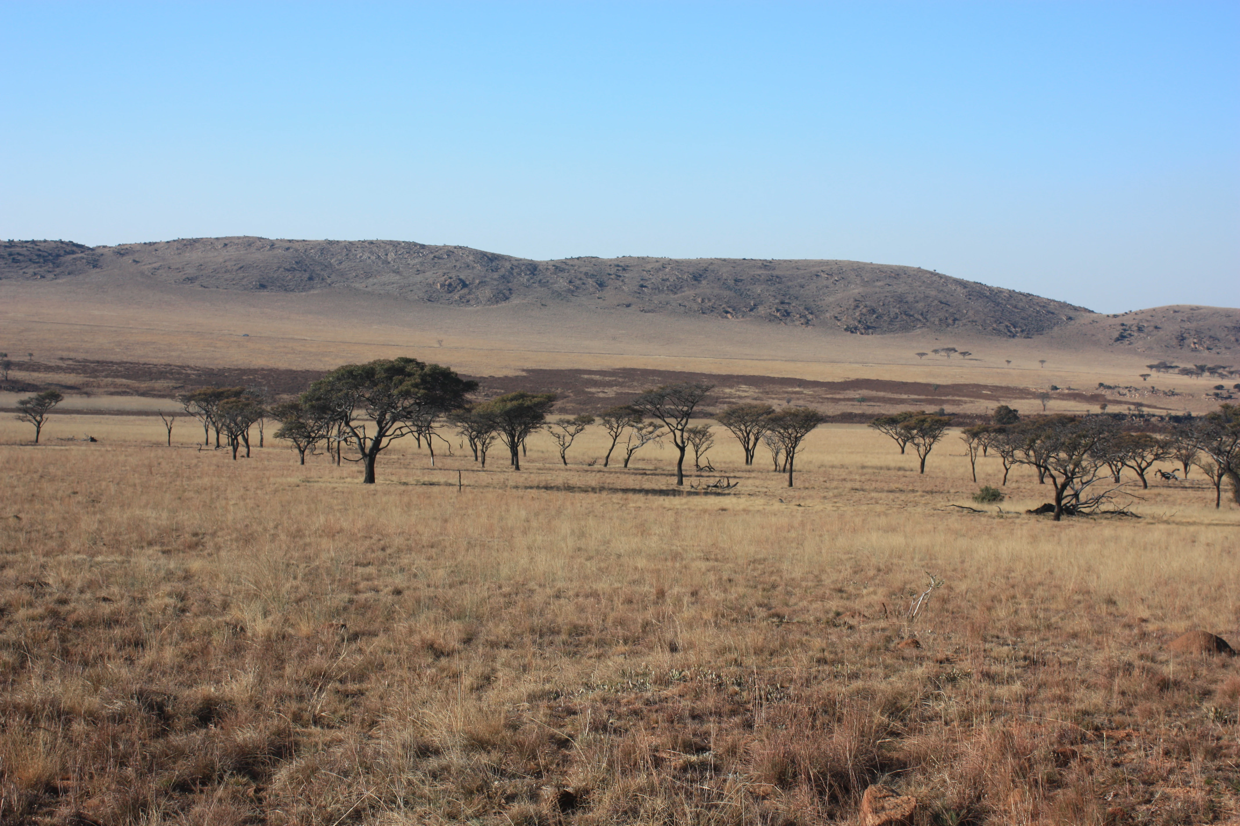
A wide, dry, golden-brown savanna landscape with scattered small trees and low, rounded mountain ridges in the background under a clear blue sky.
A wide view of the dry grasslands and low hills characterizing Kgaswane Mountain Reserve.

Kgaswane Mountain Reserve history and protected-area timeline

The reserve was originally established on the farm Rietvallei, once part of the landholdings associated with President Paul Kruger, reflecting the longer agricultural and rural land-use history of the Magaliesberg foothills. From this early farming origin, the land was gradually assembled into a larger conservation property that, in 1967, was officially proclaimed as the Rustenburg Nature Reserve, marking its formal protection as a public reserve.

Over subsequent decades the reserve expanded until it reached its current extent of roughly 53 square kilometres of veld and mountain terrain. On 21 February 2017 it was redesignated under its present name, Kgaswane Mountain Reserve, reflecting both its mountain character and its position within the broader Magaliesberg landscape. The 2019 designation as a Ramsar wetland site added an international layer of recognition to its conservation history and underlined its ecological importance beyond the provincial scale.

Kgaswane Mountain Reserve landscape and geographic character

The reserve sits on the northern slopes of the Magaliesberg, a quartzitic mountain range of considerable geological age that defines much of the natural geography between the Highveld and the bushveld. Within Kgaswane, this setting produces a landscape that shifts between steeper rocky ridges, gentler valleys, open grasslands, and denser woodland, all within a relatively compact protected footprint.

Water and wetland features are woven through this terrain, as reflected in the reserve's Ramsar designation. Natural pools along the longer hiking routes and a waterfall visible from the Baviaanskrans trail illustrate the role of seasonal and perennial drainage in shaping the local scenery. The combination of cliff-and-ridge topography with lower, more vegetated ground gives the reserve a layered visual character, with expansive views from higher trails contrasting with the enclosed feel of forested and wooded lower slopes.

Kgaswane Mountain Reserve ecosystems, habitats, and plant life

Kgaswane's ecological identity is shaped by the meeting of distinct vegetation types on a relatively small area of mountain terrain. The reserve supports grassland, scrub, mixed woodland, and isolated patches of fynbos, creating habitat diversity that supports a wide range of animal and plant communities. This mosaic is characteristic of the Magaliesberg's northern slopes, where Highveld and bushveld influences blend.

A reported 115 tree and bush species are present in the reserve, including rare plants, which gives the area botanical as well as zoological significance. Wetland features associated with the reserve's Ramsar status add another ecological dimension, providing habitat for water-associated plants, invertebrates, and birds, and linking the reserve into wider conservation frameworks concerned with both upland and wetland biodiversity.

Kgaswane Mountain Reserve wildlife and species highlights

Kgaswane supports a notably full mammal community for a reserve of its size. Antelope are the most numerous large mammals, with the reserve reporting more than 800 antelope across multiple species. These include klipspringer, grey duiker, bushbuck, kudu, oribi, mountain reedbuck, impala, red hartebeest, zebra, springbok, steenbok, sable antelope, and waterbuck, each occupying slightly different niches within the veld, woodland, and rocky habitats.

Predator presence adds another layer of ecological interest. Caracal, aardwolf, jackal, and leopard are recorded in the reserve, suggesting functioning predator-prey dynamics rather than simply a managed game population. The birdlife is the wildlife component for which Kgaswane is most widely recognised: around 320 species have been recorded, including a breeding colony of Cape vultures, martial eagles, and Verreaux's eagles, plus range-restricted and sought-after species such as the Red-winged Francolin, the African black swift, and the Sentinel rock thrush.

Kgaswane Mountain Reserve conservation status and protection priorities

Kgaswane Mountain Reserve carries multiple layers of formal conservation protection. It lies within the Magaliesberg Biosphere Reserve, recognised under UNESCO's Man and the Biosphere programme, and alongside the western portion of the Magaliesberg Protected Natural Environment, situating the reserve within a network of complementary protected-area designations.

The 2019 Ramsar designation marked a particularly important recognition of the reserve's wetland habitats and biodiversity, placing it within the international system of important wetlands. Together these designations emphasise the reserve's role in conserving representative Magaliesberg ecosystems, protecting raptor breeding habitat, and maintaining populations of indigenous antelope and smaller mammals, including predator species, in a working protected landscape.

Kgaswane Mountain Reserve cultural meaning and human context

The reserve's history is closely tied to the Magaliesberg region, one of the oldest inhabited mountain landscapes in southern Africa. The original protected property, the farm Rietvallei, was once part of the land associated with President Paul Kruger, linking the reserve's origins to a significant period in South African political and rural history.

In the present day, the reserve's role in regional identity is more strongly framed around the Magaliesberg as a shared natural heritage, connecting Kgaswane to neighbouring protected areas, biosphere initiatives, and public outdoor culture in North West Province and Gauteng.

Top sights and standout views in Kgaswane Mountain Reserve

Kgaswane's strongest point of distinction is the combination of a fully developed Magaliesberg mountain landscape with an unusually rich mammal and bird community, including a breeding population of Cape vultures. The reserve's Ramsar status reinforces its importance beyond routine game-viewing destinations.

For visitors, the reserve stands out for the diversity of experiences it supports at a relatively accessible distance from Rustenburg and Gauteng, ranging from short bird-focused walks to demanding multi-day mountain hikes with natural swimming pools and waterfalls.

Best time to visit Kgaswane Mountain Reserve

Kgaswane is open throughout the year, and its mountain setting means that seasonal conditions meaningfully shape the visitor experience. Cooler, drier months tend to produce more comfortable hiking conditions, clearer visibility from higher ridges, and more active mammal movement during daylight hours, which also benefits birdwatching along the shorter trails.

Wet seasons bring lusher grass and fuller wetland features, which can influence bird activity and the character of lower-lying vegetation, but heavy summer rain may also make rocky and steep trails more challenging. For visitors prioritising raptors and broader bird lists, mild seasons with stable weather are typically the most rewarding; for those drawn to green landscapes and saturated scenery, late summer visits often feel the most lush.
Monthly climate preview

Track representative annual temperature ranges and precipitation normals across twelve distinct months

Kgaswane Mountain Reserve Climate and Long-Term Monthly Weather Patterns

Representative coordinate records show measured monthly temperature variations and precipitation distribution across the reserve elevation. Reviewing these multi-year climate normals provides essential baseline data for understanding regional environmental rhythms.
Annual mean20 °C
13 °C25 °C
Jan25°
Feb24°
Mar23°
Apr20°
May16°
Jun13°
Jul13°
Aug16°
Sep21°
Oct23°
Nov24°
Dec25°
Warmest month
January

24.8 °C

Coolest month
July

12.7 °C

Wettest month
January

3.7 mm/day

Driest month
July

0.1 mm/day

Park location guide

Geography guide, regional context, and park location map for Kgaswane Mountain Reserve

Kgaswane Mountain Reserve park geography, regions, and map view in South Africa

Understand where Kgaswane Mountain Reserve sits in South Africa through a broader geographic reading of the surrounding landscape, nearby location context, and its mapped position within the national park landscape.

How Kgaswane Mountain Reserve fits into South Africa

South Africa is the southernmost country in Africa, spanning 1.22 million km² with a population of over 63 million. The country operates with three capital cities, Pretoria (executive), Cape Town (legislative), and Bloemfontein (judicial), and is renowned for its biodiversity, national parks, and multicultural society.

Wider geography shaping Kgaswane Mountain Reserve in South Africa

South Africa occupies the southernmost region of Africa, with coastline along both the Atlantic Ocean to the west and the Indian Ocean to the east. The interior features elevated plateaus including the Highveld, with the Drakensberg escarpment marking the eastern highlands. The country shares borders with Namibia, Botswana, Zimbabwe, Mozambique, Eswatini, and Lesotho.

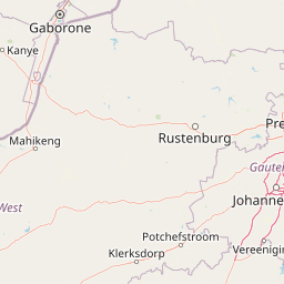
Map view of Kgaswane Mountain Reserve

Use this park location map to pinpoint Kgaswane Mountain Reserve in South Africa, understand its exact geographic position, and read its mapped placement within the surrounding landscape more clearly.

Pigeon | © OpenStreetMap contributors

Location context for Kgaswane Mountain Reserve

North West
Recorded earthquake history

View Recorded Seismic Activity Near Kgaswane Mountain Reserve

Access the comprehensive historical earthquake catalogue associated with Kgaswane Mountain Reserve. Review recorded seismic data, including event magnitude and epicentre proximity, to learn more about the geological context of this Magaliesberg destination within the MoriAtlas archive.

Kgaswane Mountain Reserve Earthquake History

Catalogued events

21 events

Strongest magnitude

Magnitude 5.1

Most recent event

Jan 31, 2022

This history includes earthquakes recorded inside the park or within 50 km of its borders

Explore protected area photography highlighting ridge terrain, grassland habitats, and wildlife

Kgaswane Mountain Reserve Photos and Scenery: Visualizing the Magaliesberg Landscape

Visual documentation captures the quartzitic ridges, mixed woodland, and wetland environments that define Kgaswane Mountain Reserve. Examining field photography reveals the complex topography and ecological character of the protected landscape.

A wide, dry, golden-brown savanna landscape with scattered small trees and low, rounded mountain ridges in the background under a clear blue sky.

A flowering Common Sugarbush tree standing in a grassy field with rolling mountain slopes in the background.

Park atlas

Compare adjacent mountain reserves and protected landscapes across the surrounding region

Other Parks Near Kgaswane Mountain Reserve And Regional Protected Areas

Browse nearby national parks and protected areas sharing similar mountain terrain, rich raptor habitats, and diverse veld ecosystems. Comparing adjacent reserves helps reveal the broader ecological patterns and regional geography framing the Magaliesberg range.
A watercolor illustration of rolling green hills, distant mountains, and a pale sky.
Protected landscapeNorth West
About 33 km away#1 closest

East

Magaliesberg Protected Natural Environment: Mapped Geography and Protected Landscape Context

Ancient mountain ridges between Rustenburg and Pretoria

Spanning a long quartzite ribbon, the Magaliesberg Protected Natural Environment represents a sophisticated model of private land conservation. The geography reveals a dramatic elevation gradient where Highveld plateaus meet lower-lying bushveld terrain. This atlas entry details the protected boundaries and the integrated landscape connection between surrounding nature reserves.

Area
343.56 km²
Established
1994
Relief
Mountain
Scope
Terrestrial
Watercolor painting of a river flowing through a hilly, green valley with rocky cliffs on the right.
Biosphere reserveNorth West
About 35 km away#2 closest

East

Magaliesberg Biosphere Reserve: Geographic Overview and Protected Area Landscape Mapping

Ancient mountain ranges in South Africa

The Magaliesberg Biosphere Reserve features a rugged terrain of high ridges and deep kloofs that support a vast array of bird species and vegetation. As a significant conservation area in North West, it preserves geological history alongside critical transitional ecosystems. Discover the mapped boundaries and natural features of this protected region that bridges urban centers and wilderness.

Area
3,578.7 km²
Established
2015
Relief
Mountain
Climate
Subtropical
A pale, minimalist watercolor painting depicting rolling green hills in the distance with a winding dirt path leading through grassy plains in the foreground.
National parkNorth West Province
About 46 km away#3 closest

North

Pilanesberg National Park: Geologic Mapping of a South African Alkaline Ring Complex

Explore concentric volcanic terrain and protected bushveld landscapes

Pilanesberg National Park covers the eroded root of a massive 1.2 billion year old volcano. Its defining feature is a series of concentric hills and basins that rise from the flat bushveld plains of South Africa. This protected area offers a distinct geographic study in volcanic topography, featuring rocky syenite outcrops, open savanna, and varied water sources that define the ecological character of this significant regional landscape.

Area
572 km²
Established
1984
Relief
Mountain
Climate
Subtropical
Nature reserveGauteng
About 59 km away#4 closest

South

Abe Bailey Nature Reserve: Geographic Profile and Highveld Protected Area Atlas

Mapped wetlands and grassland ecosystems in Gauteng, South Africa

Spanning 4,200 hectares, Abe Bailey Nature Reserve provides a vital green refuge on the West Rand. This protected area features a unique combination of highveld grassland, seasonal wetlands, and rocky ridges that support rich birdlife and antelope populations, standing as a significant conservation feature within an urbanized province.

Area
42 km²
Relief
Upland
Climate
Temperate
Access
Access unknown
Wildlife reserveNorth West Province
About 85 km away#5 closest

Northeast

Borakalalo Game Reserve: Protected Bushveld and Aquatic Landscapes in North West Province

Mapping a diverse South African wildlife reserve

Borakalalo Game Reserve features a distinct ecological setting within South Africa, combining woodland bushveld with the aquatic ecosystems of Klipvoor Dam. This protected area provides a habitat for varied mammal species and an extensive bird list, set against the backdrop of the interior plateau landscape in North West Province.

Area
130 km²
Relief
Upland
Access
Access unknown
Scope
Terrestrial
A soft watercolor illustration depicting rolling green hills and subtle landscape features on a white background.
Nature reserveGauteng
About 96 km away#6 closest

East

Klapperkop Nature Reserve: Mapping Protected Bankenveld and Highveld Landscapes

A vital protected nature reserve in Gauteng, South Africa

Klapperkop Nature Reserve protects a representative segment of threatened highveld bankenveld grassland near Pretoria. The reserve features the distinct Klapperkop hill, historic fortifications, and restored savanna ecosystems that offer a window into the natural heritage of the Gauteng region.

Area
4.6 km²
Established
1898
Relief
Upland
Climate
Subtropical
Biosphere reserveLimpopo
125 km away#7 closest

Northeast

Waterberg Biosphere: A Protected Sandstone Massif in Limpopo Province South Africa

Geology, mapping, and ecological zones of the Waterberg range

The Waterberg Biosphere stands as a major protected region in South Africa, formed by ancient sandstone layers sculpted into mesas and deep gorges. This massif bridges ecological zones from highland savanna to riverine habitats, anchoring a network of game reserves and wilderness areas through its distinctive geological and historical landscape identity.

Area
6,540.33 km²
Established
2001
Relief
Mountain
Climate
Subtropical
Nature reserveLimpopo
About 127 km away#8 closest

Northeast

Mabalingwe Nature Reserve: Protected Bushveld Geography and Terrain Analysis

Mapping the Limpopo reserve landscape and habitat features

Examine the 8,800-hectare landscape of Mabalingwe Nature Reserve. From its malaria-free bushveld habitat to its network of seasonal dams and mixed woodland terrain, this entry provides a clear look at the environmental context of this private Limpopo protected area.

Area
88 km²
Established
1989
Relief
Upland
Climate
Subtropical

Common questions about visiting, size, designation, and location context for Kgaswane Mountain Reserve

Kgaswane Mountain Reserve FAQs for park facts, access, geography, and protected area context

Find quick answers about Kgaswane Mountain Reserve, including protected-area facts, park geography, trail and visitor context, and how the park fits into its surrounding country and regional landscape.
MoriAtlas Explorer

Continue Your Protected Areas Search Across the Global Atlas

Deepen your exploration by continuing the structured search for national parks and protected areas worldwide. Utilize the comprehensive filtering capabilities to compare different conservation landscapes and refine your understanding of global park geography. Discover more about the distribution and characteristics of protected natural areas.

Global natural geography