Mori Atlas logo
Nature reserveKiesgrube Wahn

Examining the ecological mosaic and territorial boundaries of this significant post-industrial habitat

Kiesgrube Wahn Nature Reserve: A Detailed Geographic Survey of Protected Landscapes in Cologne

(Naturschutzgebiet Kiesgrube Wahn)

Kiesgrube Wahn represents a vital protected area situated within the Bergische Heideterrasse region of North Rhine-Westphalia. This nature reserve serves as an essential case study for habitat restoration, featuring a complex array of open water, pioneer sandy-gravelly soils, and willow-dominated woodland. The site functions as a refuge for diverse species, effectively demonstrating the ecological value derived from the transformation of former extraction pits into managed wilderness.

gravel pitnature reservewetlandpioneer vegetationbirdwatchingbat habitat

Kiesgrube Wahn

Nature reserve

Park overview

Structured park overview, official facts, and landscape profile for Kiesgrube Wahn

Kiesgrube Wahn park facts, protected area profile, and essential visitor context

Review the core facts for Kiesgrube Wahn, including designation, size, terrain, visitor scale, habitats, and operating context in one park-focused overview.

About Kiesgrube Wahn

Kiesgrube Wahn is a designated nature reserve that illustrates the ecological recovery potential of former mineral extraction sites in the Lower Rhine region. Situated in the southern part of Cologne within the Porz district, it sits on the Bergische Heideterrasse, a landscape terrace shaped by Quaternary sand and gravel deposits that supports a characteristic mosaic of heath, woodland, and wetland habitats.

The reserve originated on land that had been worked as a sand and gravel quarry. When excavation ended, the disturbed ground, exposed pit floors, and steep former pit walls were not reclaimed for agriculture or development but were instead placed under formal protection in 1988. The management objective was, and remains, to conserve the raw pioneer soils and to allow the natural development of valuable wet and aquatic habitats within a broader network of post-extraction sites around Cologne.

Despite its compact footprint, Kiesgrube Wahn has proven to be extraordinarily rich ecologically. The hydrology of the site exposes the regional groundwater table in two main waterbodies on the east and south sides of the pit, with an additional water feature on the north side. Around these waterbodies the sandy-gravelly substrate supports dry and seasonally moist open-ground communities, while the former pit edges have developed into willow-dominated mixed woodland with mostly natural vegetation. Only on the sun-exposed northern and northeastern slopes do the old pit walls remain open, providing important conditions for pioneer species and solitary bees.

A biotope care plan adopted in 1990 and a revised management and development plan from 2015 guide the active stewardship of the site, including staged mowing of the pit floor, removal of encroaching shrubs on steep slopes, control of non-native trees such as black locust and staghorn sumac, and maintenance of open pit walls for wild bees and grasshoppers. The reserve is fenced and, given its small size and sensitivity to disturbance, is not open to public entry, with information panels explaining the access restrictions to visitors passing by.

Quick facts and research context for Kiesgrube Wahn

Kiesgrube Wahn is a nature reserve in the Porz district of Cologne, North Rhine-Westphalia, and is part of the Bergische Heideterrasse. It was designated in 1988 on a former sand and gravel excavation site.

The protected area covers a compact footprint and is managed under a biotope care plan first established in 1990 and updated in 2015 under the designation Naturschutzgebiet N 16 Kiesgrube Köln-Wahn. Its features include two larger waterbodies in the east and south, a third waterbody on the north side, sandy-gravelly raw soils on the pit floor, and willow-dominated mixed woodland along the former pit edges.

Monitoring carried out by the NABU Köln/Leverkusen station in 2012 and 2013 recorded 43 bird species, 7 bat species, 4 amphibians, 20 dragonfly species, 7 grasshopper species, 12 butterfly species, and 190 vascular plant species, many of them of Red List or conservation concern.

Protection and recognition

Documented territorial designation facts and administrative recognition records

Kiesgrube Wahn Protection Status and Terrestrial Conservation Scope

Kiesgrube Wahn maintains a defined terrestrial protection scope within its recorded conservation framework. Official records compile administrative designation metrics, management jurisdiction details, and verified international recognition sources.

Protection details

Protection scope
Terrestrial
Park context

Deeper park guide and search-rich context for Kiesgrube Wahn

Kiesgrube Wahn history, landscape, wildlife, and travel context

Explore Kiesgrube Wahn through its history, landscape character, ecosystems, wildlife, conservation priorities, cultural context, and seasonal travel timing in a structured park guide built for atlas discovery and search intent.

Why Kiesgrube Wahn stands out

Kiesgrube Wahn is best known as an example of how a former commercial gravel pit can be repurposed into a high-value nature reserve. Its combination of open water, raw sandy-gravelly soils, and surrounding pioneer woodland has produced an unusually rich mosaic of habitats for an area of its size. The reserve is particularly noted for its breeding and feeding birdlife, with 29 of 43 recorded bird species breeding on site, and for the presence of several Red List species including the Common Nightingale, Yellowhammer, Willow Warbler, Icterine Warbler, and Eurasian Bullfinch. It also hosts important bat populations, the rare Large Pond Mussel, and a notable assemblage of dragonflies and butterflies.
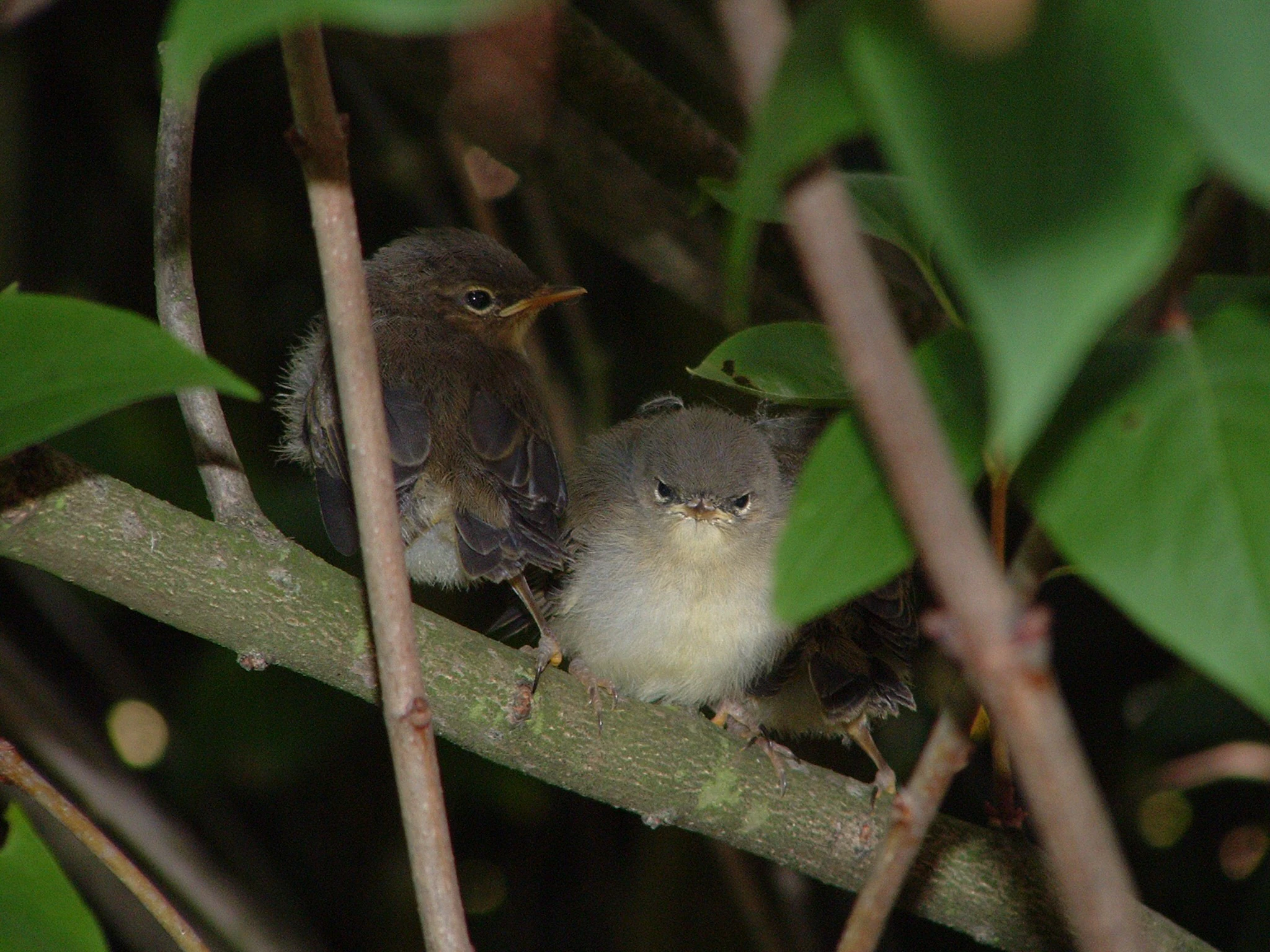
Two juvenile willow warbler birds perched together on a thin tree branch, partially obscured by green leaves.
Young willow warblers perched on a branch within the vegetation of the nature reserve.

Kiesgrube Wahn history and protected-area timeline

The history of Kiesgrube Wahn begins with industrial landscape change. The site was originally worked as an excavation area for Quaternary sands and gravels, leaving behind a depression with exposed groundwater, raw sandy and gravelly substrates, and steep pit edges.

In 1988 the former extraction site was formally designated as a nature reserve (Naturschutzgebiet) with the explicit aim of preserving the raw soils and promoting the natural development of wet and aquatic habitats on a former quarry floor. This made it one of several post-extraction sites around Cologne integrated into a regional biotope network centered on former gravel pits.

A first biotope care plan was drawn up in 1990 to guide active management of the site. In 2012 and 2013 the NABU Köln/Leverkusen station conducted systematic area monitoring covering birds, bats, amphibians, dragonflies, grasshoppers, butterflies, plants, and aquatic mollusks, providing the baseline data that informed a revised management and development plan adopted in 2015 under the designation Naturschutzgebiet N 16 Kiesgrube Köln-Wahn. The 2015 plan continues to guide conservation measures including staged mowing, scrub clearance, removal of non-native woody species, and the creation of temporary small waterbodies to support dragonfly breeding.

Kiesgrube Wahn landscape and geographic character

Kiesgrube Wahn occupies a small, distinctly human-shaped piece of terrain created by sand and gravel extraction. The dominant landforms are the flat or gently undulating pit floor and the surrounding pit walls and edges, which together enclose an internal basin with several water surfaces.

Two larger waterbodies lie on the east and south sides of the former pit, where the excavation reached the groundwater table. A third water feature is located on the north side. The pit floor itself consists of raw sandy-gravelly material, and the substrate varies from dry and well-drained patches to seasonally moist areas where groundwater influence is stronger.

Around the margins of the pit, former extraction slopes have been colonized by a willow-dominated mixed woodland with largely natural regeneration. On the sun-exposed northern and northeastern slopes the old pit walls remain open and bare, creating warm microhabitats important for pioneer vegetation, solitary bees, and certain grasshoppers. Overall the landscape is a small but clearly structured mosaic of open water, dry and wet open ground, bare mineral substrate, and young woodland edge.

Kiesgrube Wahn ecosystems, habitats, and plant life

Ecologically, Kiesgrube Wahn represents a classic example of a secondary raw-soil habitat community. The mineral substrate, the absence of prolonged agricultural use, and the pattern of dry and moist microhabitats have created conditions for a diverse pioneer flora and associated fauna.

Vegetation surveys recorded 190 species of ferns and flowering plants, including nine Red List species. Notable finds include Spring Cinquefoil (Frühlings-Fingerkraut), which is relatively rare in the gravel pits around Cologne, along with several forget-me-nots, centauries, Rough Pink, and specific sedges and fescues. The vegetation around the waterbodies is regarded as particularly valuable, and the eastern pond has been recognized as containing a habitat type listed under the EU Habitats Directive (FFH), giving it specific conservation significance within the reserve. White Water Lily has been recorded on the open water.

The combination of early-successional habitats, edge woodland, and standing water makes the site ecologically richer than its small size would suggest, and the NABU assessment placed the overall ecological value of the vegetation as high.

Kiesgrube Wahn wildlife and species highlights

The wildlife profile of Kiesgrube Wahn is one of the reserve's defining strengths. Avifauna monitoring identified 43 bird species using the site, with 29 confirmed as breeding species. Breeding birds include Willow Warbler, Icterine Warbler, Common Bullfinch, Yellowhammer, Lesser Whitethroat, Common Nightingale, Common Starling, and Water Rail, species that are either Red List-listed, considered endangered, or appear on early-warning lists. Kingfisher, Northern Goshawk, Eurasian Sparrowhawk, and Barn Swallow are regularly observed feeding in the former pit without nesting there.

The high insect density around the open water and the presence of cavity-bearing trees along the pit edges make the reserve an important hunting and summer roosting area for bats. Seven bat species have been confirmed, including Fringe-lipped and Brown Long-eared Bat, as well as Brandt's and Whiskered Bats, all of which appear on Red Lists.

The waterbodies support four amphibian species, 20 dragonfly species including three Red List species (Blue-winged Jewel, Broad-bodied Chaser, and Black Darter), and the rare Large Pond Mussel, itself a Red List mollusk. Additional invertebrate records include seven grasshopper species and 12 butterfly species, with conservation-priority taxa such as the Blue-winged Wingless Grasshopper, Small Heath, and the Cinnabar moth among those documented.

Kiesgrube Wahn conservation status and protection priorities

Kiesgrube Wahn holds clear value for conservation despite, and in part because of, its small size. Designated in 1988, it protects a former extraction site whose raw soils and groundwater-fed waterbodies have produced habitats of relevance for regional biodiversity and for the conservation of species struggling in more intensively used landscapes.

The reserve is embedded in the broader biotope network of former gravel pits around Cologne, meaning its populations of pioneer plant species, wetland birds, and rare invertebrates contribute to a wider functional network rather than functioning as isolated records. The presence of an FFH habitat type in the eastern waterbody further connects the site to the European Natura 2000 conservation framework and underlines the importance of its wetland vegetation.

Conservation management is active rather than passive. A 2015 management and development plan codifies measures such as staged mowing of the pit floor to maintain pioneer conditions, regular scrub clearance on steep slopes, removal of non-native woody species like black locust and staghorn sumac, de-weeding of the smaller northern pond, and the creation of temporary small waterbodies intended to provide breeding habitat for dragonflies. The fenced boundary and prohibition on public access are themselves conservation measures, protecting the fragile habitats and breeding birds from the disturbance their small footprint cannot absorb.

Kiesgrube Wahn cultural meaning and human context

Kiesgrube Wahn has no prominent historical or cultural significance in the traditional sense. The site is a product of relatively recent industrial land use rather than of older settlement, agriculture, or cultural heritage. Its current meaning is primarily ecological, as one of several former gravel pits around Cologne that have been brought into a network of protected areas. Within the regional context of the Bergische Heideterrasse, however, it forms part of a larger mosaic of conserved post-extraction landscapes that together shape the identity of the area as a place where former mineral working has given way to nature conservation.

Top sights and standout views in Kiesgrube Wahn

The reserve stands out for packing an exceptionally rich ecological mosaic into a very small, clearly defined site. Open water, raw sandy gravels, dry and seasonally moist open ground, and willow-dominated woodland edge all lie within a short distance of one another.

It is also notable for the density of Red List species recorded across multiple groups: birds, bats, dragonflies, butterflies, plants, and mollusks are all represented, with the Large Pond Mussel a particularly striking find for an urban-area reserve. The continued active management under a formal plan, combined with the site's integration into the regional gravel-pit biotope network, gives Kiesgrube Wahn an outsized role in local conservation for its size.

Best time to visit Kiesgrube Wahn

Public access to Kiesgrube Wahn is restricted; the reserve is fenced and cannot be entered because of its small size and the sensitivity of its breeding birds and vegetation. Information is available at the site itself via interpretive panels, and the broader Bergische Heideterrasse landscape offers accessible surroundings. Bird activity is typically highest during the spring and early summer breeding season, while dragonflies and butterflies are most visible in the warmer months around the waterbodies.


Monthly climate preview

Long term temperature and precipitation patterns across twelve recorded months

Kiesgrube Wahn Climate Normals and Annual Weather by Month

Kiesgrube Wahn records measured mean temperatures ranging from 1.32 degrees Celsius in January to 19.15 degrees Celsius in July alongside consistent daily precipitation averages. Examining the complete monthly climate profile reveals detailed temperature ranges and precipitation trends for this protected location.
Annual mean10 °C
1 °C19 °C
Jan
Feb
Mar
Apr
May13°
Jun17°
Jul19°
Aug19°
Sep15°
Oct10°
Nov
Dec
Warmest month
July

19.2 °C

Coolest month
January

1.3 °C

Wettest month
December

2.6 mm/day

Driest month
April

1.6 mm/day

Park location guide

Geography guide, regional context, and park location map for Kiesgrube Wahn

Kiesgrube Wahn park geography, regions, and map view in Germany

Understand where Kiesgrube Wahn sits in Germany through a broader geographic reading of the surrounding landscape, nearby location context, and its mapped position within the national park landscape.

How Kiesgrube Wahn fits into Germany

Germany is a federal republic in Western and Central Europe with a population of over 83 million across sixteen constituent states. It is Europe's largest economy by nominal GDP and a major global exporter and importer. The capital is Berlin, and the country borders Denmark, Poland, Czech Republic, Austria, Switzerland, France, Luxembourg, Belgium, and the Netherlands.

Wider geography shaping Kiesgrube Wahn in Germany

Germany is located in Western and Central Europe, spanning 357,022 km². It borders Denmark to the north, Poland and the Czech Republic to the east, Austria and Switzerland to the south, and France, Luxembourg, Belgium, and the Netherlands to the west. The country has coastlines on the Baltic Sea and North Sea to the north, with the Alps located in the southern region.

Map view of Kiesgrube Wahn

Use this park location map to pinpoint Kiesgrube Wahn in Germany, understand its exact geographic position, and read its mapped placement within the surrounding landscape more clearly.

Pigeon | © OpenStreetMap contributors

Location context for Kiesgrube Wahn

North Rhine-Westphalia

Examine the terrain, open water, and pioneer woodland defining this reserve.

Kiesgrube Wahn Photos and Landscape Scenery: Visualizing Protected Habitats

Visual records capture the distinctive sandy terrain, wetland mosaic, and raw mineral soils that characterize Kiesgrube Wahn. Photographic evidence reveals how post-industrial gravel extraction transformed into a vital refuge for rare regional wildlife.

Two juvenile willow warbler birds perched together on a thin tree branch, partially obscured by green leaves.

Park atlas

Compare surrounding regional geography and connected wetland habitats

Other Parks and Protected Areas Near Kiesgrube Wahn

Browsing parks near Kiesgrube Wahn reveals a broader network of protected landscapes and post industrial nature reserves across North Rhine-Westphalia. Extending the geographic comparison allows for deeper exploration of regional wetland habitats, heath terraces, and biodiversity corridors.
Nature reserveCologne
About 1.7 km away#1 closest

Southwest

Kiesgruben Paulsmaar Nature Reserve: Landscape and Geography in the Cologne Urban Fringe

A managed mosaic of post-industrial gravel pits and wetland habitats.

Kiesgruben Paulsmaar represents a distinct example of urban-edge habitat restoration in western Germany. Located near the border of Cologne, this 24-hectare nature reserve consists of three interconnected water bodies, floodplain forests, and calcareous grasslands. It serves as a regional refuge for biodiversity while documenting the conversion of former industrial land into a functioning wetland ecosystem.

Area
0.247 km²
Established
1991
Relief
Lowland
Climate
Temperate
A horizontal watercolor painting depicting a gentle, hazy green landscape with rolling hills, a line of trees, and a foreground meadow.
Protected landscapeNorth Rhine-Westphalia
About 3.4 km away#2 closest

West

Naturpark Rheinland: Geography and Protected Area Overview in North Rhine-Westphalia

A complex metropolitan nature park and lake district

Naturpark Rheinland represents a distinct convergence of reclaimed lignite mining landscapes, quiet lowland forests, and floodplain wetlands. Its mapped boundaries reveal a diverse terrain of ridges and river valleys that define the environmental character of the Cologne-Bonn metropolitan region.

Area
1,045 km²
Established
1959
Relief
Upland
Climate
Temperate
A soft, pale watercolor illustration of a lake with small islands and a low, distant treeline.
Nature reserveNorth Rhine-Westphalia
About 7 km away#3 closest

Northwest

Kiesgrubensee Gremberghoven Nature Reserve Geographic and Protected Area Overview

A restored industrial gravel pit ecosystem in North Rhine-Westphalia.

Kiesgrubensee Gremberghoven functions as a protected nature reserve in the Cologne metropolitan area. The site is defined by its origin as a former gravel excavation, now containing a substantial lake that attracts waterbirds and supports cliff-nesting colonies along its steep sandy slopes. This location serves as an informative case study for understanding how industrial remnants in German landscapes can be rehabilitated for conservation and ecological study.

Area
0.377 km²
Established
1989
Relief
Lowland
Climate
Temperate
Watercolor landscape illustration showing a pale river curving through green trees with soft hills in the distance.
Nature reserveNorth Rhine-Westphalia
About 7.6 km away#4 closest

West

Langeler Auwald: A Protected Floodplain Forest in the North Rhine-Westphalia Rhine Corridor

Examining fluvial landscape patterns and riparian forest boundaries

Langeler Auwald functions as a significant nature reserve on the right bank of the Rhine in Cologne, preserving a rare mosaic of willow-poplar floodplain forest. The terrain encompasses periodically flooded gravel shores, nutrient-poor grasslands on flood dikes, and transitional orchard habitats that support a high density of protected species within the urbanized landscape of North Rhine-Westphalia.

Area
0.224 km²
Relief
Lowland
Climate
Temperate
Scope
Terrestrial
A horizontal watercolor painting of a river landscape with lush green trees, fields, and a distant church spire on the horizon.
Nature reserveRhein-Sieg-Kreis
About 8.5 km away#5 closest

South

Siegaue und Siegmündung Nature Reserve in Rhein-Sieg-Kreis: A Geographic Overview

Protected floodplain ecosystems and river-mouth geography

The Siegaue und Siegmündung nature reserve protects a critical river-mouth landscape where the Sieg flows into the Rhine. This area features a complex mosaic of wet meadows, softwood alluvial forests, and abandoned river channels, providing essential habitat for migratory waders. The reserve represents a near-natural floodplain environment within the densely populated Cologne-Bonn Rhine plain.

Established
1985
Relief
Lowland
Climate
Temperate
Scope
Terrestrial
A soft watercolor painting showing a winding river with a lush green island in the middle, surrounded by soft-toned riverbanks and trees.
Nature reserveNorth Rhine-Westphalia
About 10 km away#6 closest

South

Herseler Werth Nature Reserve: Geographic Overview of the Rhine River Island Landscape

A strictly protected riverine refuge in North Rhine-Westphalia

Herseler Werth represents a unique study in protected geography as the only non-publicly accessible Rhine island within North Rhine-Westphalia. Spanning 14.8 hectares, this long, narrow river island serves as a critical, human-excluded sanctuary that protects endangered species from industrial and urban disturbance. Its mapped boundaries and poplar-covered terrain illustrate the complex interaction between historical river hydrology and modern conservation efforts along the busy Bonn-Cologne corridor.

Area
0.148 km²
Established
1993
Relief
Lowland
Climate
Temperate
A soft watercolor illustration of a serene pond surrounded by gentle green hills and lush shoreline vegetation in a light, pastel color palette.
Nature reserveCologne
About 11 km away#7 closest

West

Kiesgruben Meschenich: Geographic Analysis of a Cologne Nature Reserve Landscape

Examining the ecological terrain and mapped gravel-pit habitat network.

Kiesgruben Meschenich offers a distinct study in regional conservation, presenting a complex of excavation lakes, raw gravel substrates, and wetland fringes. This protected area stands as a primary example of how industrial remnants transform into valued ecological hubs, serving as a critical refuge for biodiversity in the densely populated Rhine landscape of North Rhine-Westphalia.

Area
0.265 km²
Established
1991
Relief
Lowland
Scope
Terrestrial
A soft watercolor illustration showing a peaceful landscape with gentle hills, trees, and small ponds reflecting light.
Nature reserveNordrhein-Westfalen
About 15 km away#8 closest

Southwest

Quarzsandgrube Nature Reserve: Geographic Profile and Protected Landscape Context

Protected mosaic of pioneer habitats in the Rhein-Sieg-Kreis

Located on the terrace slopes of the Rhein-Sieg-Kreis, Quarzsandgrube represents a significant refuge for early successional flora and fauna. The site features an uneven terrain of exposed sandy soils and water-filled hollows, providing a vital habitat corridor alongside adjacent protected areas. This detailed geographic profile maps the environmental conditions that define its current status as a protected nature reserve.

Area
0.29 km²
Established
1994
IUCN
IV

Common questions about visiting, size, designation, and location context for Kiesgrube Wahn

Kiesgrube Wahn FAQs for park facts, access, geography, and protected area context

Find quick answers about Kiesgrube Wahn, including protected-area facts, park geography, trail and visitor context, and how the park fits into its surrounding country and regional landscape.
MoriAtlas Explorer

Continue Your Protected Areas Search Across the Global Atlas

Deepen your exploration by continuing the structured search for national parks and protected areas worldwide. Utilize the comprehensive filtering capabilities to compare different conservation landscapes and refine your understanding of global park geography. Discover more about the distribution and characteristics of protected natural areas.

Global natural geography