Mori Atlas logo
Nature reserveKiesgruben Paulsmaar

Understanding the ecological restoration of post-industrial gravel pits within the Lower Rhine floodplain corridor.

Kiesgruben Paulsmaar Nature Reserve: A Detailed Geographic and Landscape Profile of the Cologne Urban Fringe

(Naturschutzgebiet Kiesgruben Paulsmaar)

Kiesgruben Paulsmaar is a notable nature reserve located on the urban edge of Cologne, Germany. Covering roughly 24 hectares, this protected area illustrates the transformation of former gravel extraction sites into a vibrant mosaic of interconnected lakes, floodplain forests, and species-rich grasslands. The site serves as a vital refuge for waterbirds, amphibians, and dragonflies, functioning as part of a larger network of aquatic habitats along the Rhine river corridor.

gravel pit reserveurban-edge nature reservewetland mosaicwaterbird refugeamphibian habitatdragonfly habitat

Kiesgruben Paulsmaar

Nature reserve

Park overview

Structured park overview, official facts, and landscape profile for Kiesgruben Paulsmaar

Kiesgruben Paulsmaar park facts, protected area profile, and essential visitor context

Review the core facts for Kiesgruben Paulsmaar, including designation, size, terrain, visitor scale, habitats, and operating context in one park-focused overview.

About Kiesgruben Paulsmaar

Kiesgruben Paulsmaar lies in the southern outskirts of Cologne, roughly five kilometers from the city center, four kilometers from Troisdorf, and six kilometers from Niederkassel, within a region where the Rhine floodplain meets the densely populated urban fringe of the Rhineland. The reserve is small but unusually diverse for its size, because it is built on the scarred substrate of an abandoned gravel quarry that has been deliberately reshaped into a patchwork of wetland and meadow habitats.

The structure of the site revolves around three open water bodies. The largest, older eastern lake is used by the local angling club that leases the area, while a newer western lake has been kept entirely free of fishing activity so that it functions as an undisturbed conservation water. A small pond at the northeastern end connects to the main eastern lake and provides a quieter spawning habitat for some of the introduced fish species. Between these water bodies a high embankment marks the original ground level, separating the older and newer excavations; a gas pipeline runs along its crest.

Around the lakes the vegetation forms a series of concentric habitat rings. The very narrow shallow-water zones of the two larger lakes support fragmented silver willow floodplain woodland and reedbeds, some of which were planted in sections by members of the angling club. The smaller northeastern pond contains additional reed growth and a floating-leaf zone of white water-lily. To its east a more extensive flooded willow and alder carr occupies a broad shallowing zone. Steeper outer pit slopes are largely covered with planted native deciduous trees, although the slopes around the western lake also hold significant stands of non-native red oak and black locust. Shallower, flatter areas have been planted with locally characteristic species-rich scrub.

The reserve is significant on a regional scale because it forms part of a chain of protected gravel-pit lakes and floodplain fragments that follow the Rhine, offering resting, feeding, and breeding habitat for waterbirds migrating or moving along the river corridor. It also functions as an important refuge for threatened amphibians and dragonflies in an otherwise heavily built-up landscape. The combination of formal protection status, careful angling management on one lake, complete conservation management on the other, and active landscape maintenance by an angling club makes it a recognizable example of urban-edge habitat creation in Germany.

Quick facts and research context for Kiesgruben Paulsmaar

Kiesgruben Paulsmaar is a designated nature reserve (Naturschutzgebiet) located on the southern outskirts of Cologne in the German state of North Rhine-Westphalia. The site covers about 24.68 hectares and centers on three former gravel pit lakes arranged around an older eastern lake used for angling, a newer western lake managed purely for conservation, and a small northeastern pond that connects to the larger water body.

The reserve is fenced and has been leased since 1989 to the Verein Angel- und Naturfreunde (ANF) Heimattreue Zündorf, which fishes the eastern lake and helps maintain the area. It was formally classified as worthy of protection in 1991 and forms part of the broader constellation of nature reserves near Cologne that protect gravel-pit lakes, meadows, and Rhine floodplain habitats. Its character is a patchwork of open water, silver willow floodplain forest, reedbeds, willow-alder carr, calcareous dry grassland, and plantation deciduous woodland interspersed with ruderal communities.

Protection and recognition

Terrestrial conservation records and designation history established in 1991

Kiesgruben Paulsmaar Protection Status and Designated Area Records

Kiesgruben Paulsmaar maintains a documented terrestrial protection status established in 1991. Official records outline the conservation scope and designation timeline for this protected landscape.

Protection details

Protection scope
Terrestrial
Designated year
1991
Transboundary protection
No
Park context

Deeper park guide and search-rich context for Kiesgruben Paulsmaar

Kiesgruben Paulsmaar history, landscape, wildlife, and travel context

Explore Kiesgruben Paulsmaar through its history, landscape character, ecosystems, wildlife, conservation priorities, cultural context, and seasonal travel timing in a structured park guide built for atlas discovery and search intent.

Why Kiesgruben Paulsmaar stands out

Kiesgruben Paulsmaar is best known as a small but ecologically rich urban-edge nature reserve built on former gravel workings, where three connected lakes and a ring of wetland, meadow, and woodland habitats create a refuge for waterbirds, amphibians, and dragonflies along the Rhine corridor near Cologne. The reserve is also notable for the way it combines active angling use of its older eastern pit with strict conservation management of its newer western pit, demonstrating how a heavily modified post-industrial landscape can be rehabilitated into a functioning mosaic of aquatic and terrestrial habitats in just a few decades.
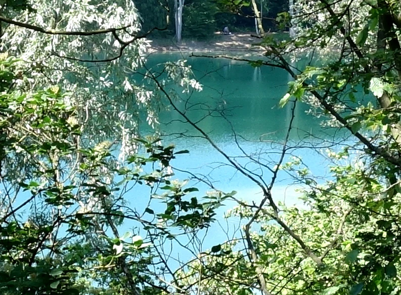
A turquoise lake surrounded by green trees and foliage, viewed through branches from a slightly elevated position.
View of the largest gravel pit lake in the Kiesgruben Paulsmaar nature reserve, seen through surrounding trees.

Kiesgruben Paulsmaar history and protected-area timeline

Kiesgruben Paulsmaar originated as a commercial gravel extraction site on the southern outskirts of Cologne. After the active quarrying phase ended, the area was gradually allowed to fill with water, producing the three pit lakes that now form the heart of the reserve. The Verein Angel- und Naturfreunde (ANF) Heimattreue Zündorf has held a lease on the area since 1989 and has been responsible both for angling activities and for much of the practical site management, including planting of reed sections around the eastern lake.

In 1991 the area was formally recognized as worthy of protection under German nature conservation law, giving it the status of a Naturschutzgebiet. This designation formalized ongoing efforts to allow parts of the abandoned quarry to develop naturally through ecological succession while restricting fisheries use in the newer western pit to maintain an undisturbed conservation water. Since designation, the reserve has continued to evolve as its reedbeds, willow-alder carr, and dry grassland communities mature, and as targeted conservation measures, such as the 2018 planting of stonewort and bladderwort species in the pit lakes, have been carried out to strengthen its aquatic character.

Kiesgruben Paulsmaar landscape and geographic character

The landscape of Kiesgruben Paulsmaar is a deliberately structured post-industrial terrain shaped by former gravel quarrying rather than by natural geomorphology. Three open water bodies sit within a fenced enclosure, separated and defined by artificial embankments, slopes, and shallow margins. The largest eastern lake is the oldest of the three and lies closest to a line of higher ground that originally separated the quarry pits, while the western lake represents the more recent phase of excavation.

Surrounding the water bodies, the land rises in steep artificial slopes that frame the lakes like walls. These slopes are mainly clothed in planted native deciduous woodland, with pockets of red oak and black locust around the newer western lake. At lake level, narrow littoral shelves support ribbon-like fringes of silver willow floodplain forest, with patches of planted reed in front of them and a floating-leaf zone of white water-lily on the smaller northeastern pond. East of this pond a large area of shallow-flooded willow and alder carr extends the wetland character inland. Flatter sectors between the slopes have been sown or planted with species-rich calcareous grassland and typical local scrub. A high separating dam, topped by successional shrubs and crossed by public paths, divides the two main lakes and still carries a gas pipeline through its body.

The result is a tightly composed small-scale landscape in which water, wetland, woodland, and meadow are arranged in clear concentric bands around a man-made core of pit lakes, embedded in the urban fringe between Cologne and the Rhine floodplain.

Kiesgruben Paulsmaar ecosystems, habitats, and plant life

Ecologically, Kiesgruben Paulsmaar is defined by the interplay between newly created still waters and the terrestrial habitats that have been allowed or encouraged to develop around them. The three pit lakes and their fringing wetlands form the biological heart of the reserve, while the surrounding slopes and mound of the separating dam support a more terrestrial mosaic of plantation woodland, scrub, dry grassland, and ruderal vegetation.

The shallows and margins of the water bodies are the most ecologically sensitive parts of the site. Fragmentary silver willow floodplan forest and patches of reed fringe the two larger lakes, while the small northeastern pond harbors white water-lily floating beds and additional reed growth. Aquatic vegetation has been actively enriched, notably through the introduction of a stonewort species in the western conservation lake in autumn 2018 and bladderwort species recorded in the two eastern waters in the same period. The dry outer slopes carry planted native broadleaf woodland with localized non-native oak and locust stands, while flatter areas support species-rich calcareous grassland and locally typical scrub. Ruderal grasslands, trampled lawns, and birch successional woodland persist in a few open, disturbed patches along paths and around the angling club's shelter.

Together these habitats create a dense micro-mosaic in which freshwater, wetland, woodland, meadow, and ruderal communities meet within a few hundred meters, supporting a disproportionately rich fauna in an otherwise urbanized setting.

Kiesgruben Paulsmaar wildlife and species highlights

The wildlife significance of Kiesgruben Paulsmaar lies primarily in its role for waterbirds and for freshwater fauna associated with newly created still waters. The pit lakes form protected feeding, resting, and breeding habitat for waterbirds using the Rhine corridor, and the reserve is explicitly recognized as an important refuge for this group in an intensively used urban landscape.

The site also has regional importance for threatened amphibians, which depend on the calm, fish-free or fish-controlled waters and their fringing reedbeds, and for dragonflies, which use the combination of open water, floating vegetation, and emergent reed as habitat. The eastern lake is used by the angling club's fish stocking, including mirror carp, pike, common bream, perch, and roach, and the smaller northeastern pond acts as a quieter spawning area for some of these species, while the western conservation lake remains unstocked. The resulting contrast between fished and unfished waters within a single small reserve supports a broader community of aquatic and semi-aquatic species than would exist in a uniformly managed site.

Kiesgruben Paulsmaar conservation status and protection priorities

Kiesgruben Paulsmaar was classified as worthy of protection in 1991 and has since operated as a formal Naturschutzgebiet, a category of nature reserve under German conservation law. Its conservation strategy focuses on the careful balance between limited human use, particularly angling on the older eastern lake, and undisturbed ecological development on the newer western lake and its surroundings.

The main conservation objectives are to restrict fisheries pressure, to maintain and restore near-natural aquatic features, and to prevent eutrophication of the still waters. The reserve is also managed by allowing large parts of the area to undergo natural ecological succession, while targeted interventions, such as the planting of reed strips by the angling club around the eastern lake and the planned establishment of additional aquatic plant species, are used to reinforce particular habitat values. Beyond its immediate biodiversity function, the reserve forms part of a wider network of protected gravel pit sites and Rhine floodplain habitats that together support waterbirds and other aquatic wildlife in the Cologne region.

Kiesgruben Paulsmaar cultural meaning and human context

Kiesgruben Paulsmaar reflects the layered history of land use in the southern outskirts of Cologne, where intensive gravel quarrying, agricultural use, and rapid urban expansion have successively reshaped the landscape. An area that was once open farmland was consolidated into the reserve and partially converted to calcareous grassland and locally typical scrub, overlaying a foundation of post-industrial quarry terrain.

The presence of the long-standing angling club Verein Angel- und Naturfreunde (ANF) Heimattreue Zündorf, which has leased the area since 1989, has given the site its present-day social identity. The club both fishes the older eastern lake and contributes substantially to habitat management, illustrating the German tradition in which angling associations cooperate actively in the practical stewardship of small nature reserves. The result is a protected landscape that is simultaneously a working recreational fishing ground and a formally protected ecological refuge.

Top sights and standout views in Kiesgruben Paulsmaar

A small but tightly composed urban-edge nature reserve built on former gravel workings, with three interconnected pit lakes forming the core of the site.

The reserve combines active angling use on its main eastern lake with full conservation management of its newer western lake, demonstrating an unusual within-site contrast between managed and unmanaged still waters.

Narrow belts of silver willow floodplain forest, planted reedbeds, white water-lily stands, and willow-alder carr give the lakes well-developed wetland margins despite their artificial origin.

Externally, planted native broadleaf woodland, pockets of red oak and locust on the western slopes, and species-rich calcareous grassland frame the water bodies, while ruderal grasslands on the separating dam round out the habitat mosaic.

The site functions as a regional refuge for waterbirds following the Rhine corridor, as well as for threatened amphibians and dragonflies, placing it within a broader network of protected gravel-pit habitats around Cologne.

Best time to visit Kiesgruben Paulsmaar

Kiesgruben Paulsmaar is essentially a quiet year-round nature reserve, and its character shifts mainly with the seasons rather than with tourism cycles. Spring is the most rewarding period for visiting interest, when waterbird passage along the Rhine is at its height, amphibians are active around the lakes, and the surrounding dry grasslands and scrub are coming into bloom.

Summer brings the fullest expression of the wetland vegetation, with white water-lily stands in flower on the smaller pond, dense reed growth along the larger lakes, and active dragonfly populations across all three water bodies. Autumn is a good season for observing migratory waterbirds using the lakes as a stopover along the Rhine corridor, while winter can offer calm conditions for watching overwintering waterfowl on the unfrozen water. Because the reserve is fenced and access is restricted to the leasing angling club, the practical experience of visiting is largely one of viewing the area from its perimeter paths rather than entering the core habitat.


Monthly climate preview

Long term representative measurements and monthly weather patterns for Kiesgruben Paulsmaar

Kiesgruben Paulsmaar Climate Normals, Annual Temperature and Precipitation Rhythm

Kiesgruben Paulsmaar exhibits measured monthly temperature variation from sub zero winter lows to warm summer maximums alongside steady precipitation rates. Detailed long term climate normals reveal twelve month trends across average minimum and maximum points at the representative coordinate.
Annual mean10 °C
1 °C19 °C
Jan
Feb
Mar
Apr
May13°
Jun17°
Jul19°
Aug19°
Sep15°
Oct10°
Nov
Dec
Warmest month
July

19.2 °C

Coolest month
January

1.3 °C

Wettest month
December

2.6 mm/day

Driest month
April

1.6 mm/day

Park location guide

Geography guide, regional context, and park location map for Kiesgruben Paulsmaar

Kiesgruben Paulsmaar park geography, regions, and map view in Germany

Understand where Kiesgruben Paulsmaar sits in Germany through a broader geographic reading of the surrounding landscape, nearby location context, and its mapped position within the national park landscape.

How Kiesgruben Paulsmaar fits into Germany

Germany is a federal republic in Western and Central Europe with a population of over 83 million across sixteen constituent states. It is Europe's largest economy by nominal GDP and a major global exporter and importer. The capital is Berlin, and the country borders Denmark, Poland, Czech Republic, Austria, Switzerland, France, Luxembourg, Belgium, and the Netherlands.

Wider geography shaping Kiesgruben Paulsmaar in Germany

Germany is located in Western and Central Europe, spanning 357,022 km². It borders Denmark to the north, Poland and the Czech Republic to the east, Austria and Switzerland to the south, and France, Luxembourg, Belgium, and the Netherlands to the west. The country has coastlines on the Baltic Sea and North Sea to the north, with the Alps located in the southern region.

Map view of Kiesgruben Paulsmaar

Use this park location map to pinpoint Kiesgruben Paulsmaar in Germany, understand its exact geographic position, and read its mapped placement within the surrounding landscape more clearly.

Pigeon | © OpenStreetMap contributors

Visualizing the post-industrial terrain, wetland habitats, and protected environment

Kiesgruben Paulsmaar Photos and Landscape Scenery

Examine detailed photography revealing the interconnected pit lakes, wetland margins, and woodland sectors of Kiesgruben Paulsmaar. Photographic records provide visual reference for understanding the ecological composition and structural character of this urban reserve.

A turquoise lake surrounded by green trees and foliage, viewed through branches from a slightly elevated position.

Park atlas

Compare adjacent wetland habitats and protected landscapes across the Lower Rhine corridor

Parks Near Kiesgruben Paulsmaar: Explore Protected Areas and Surrounding Regional Reserves

Browse other parks near Kiesgruben Paulsmaar to examine related post-industrial nature reserves and aquatic habitats throughout the surrounding region. Comparing these nearby protected areas reveals wider ecological patterns across the urban fringe and the Rhine floodplain.
Nature reserveNorth Rhine-Westphalia
About 1.7 km away#1 closest

Northeast

Kiesgrube Wahn Nature Reserve: Mapped Geography and Protected Area Context

Protected landscape within the Bergische Heideterrasse of North Rhine-Westphalia

Kiesgrube Wahn provides a compact, high-value ecological mosaic in Cologne, Germany. This former gravel pit has transitioned into a protected nature reserve, hosting a range of aquatic and woodland environments that support rare plant and animal communities within the regional gravel-pit network.

Area
0.054 km²
Established
1988
Relief
Lowland
Access
Highly restricted
A horizontal watercolor painting depicting a gentle, hazy green landscape with rolling hills, a line of trees, and a foreground meadow.
Protected landscapeNorth Rhine-Westphalia
About 3.6 km away#2 closest

West

Naturpark Rheinland: Geography and Protected Area Overview in North Rhine-Westphalia

A complex metropolitan nature park and lake district

Naturpark Rheinland represents a distinct convergence of reclaimed lignite mining landscapes, quiet lowland forests, and floodplain wetlands. Its mapped boundaries reveal a diverse terrain of ridges and river valleys that define the environmental character of the Cologne-Bonn metropolitan region.

Area
1,045 km²
Established
1959
Relief
Upland
Climate
Temperate
Watercolor landscape illustration showing a pale river curving through green trees with soft hills in the distance.
Nature reserveNorth Rhine-Westphalia
About 6.3 km away#3 closest

West

Langeler Auwald: A Protected Floodplain Forest in the North Rhine-Westphalia Rhine Corridor

Examining fluvial landscape patterns and riparian forest boundaries

Langeler Auwald functions as a significant nature reserve on the right bank of the Rhine in Cologne, preserving a rare mosaic of willow-poplar floodplain forest. The terrain encompasses periodically flooded gravel shores, nutrient-poor grasslands on flood dikes, and transitional orchard habitats that support a high density of protected species within the urbanized landscape of North Rhine-Westphalia.

Area
0.224 km²
Relief
Lowland
Climate
Temperate
Scope
Terrestrial
A soft, pale watercolor illustration of a lake with small islands and a low, distant treeline.
Nature reserveNorth Rhine-Westphalia
About 7.7 km away#4 closest

Northwest

Kiesgrubensee Gremberghoven Nature Reserve Geographic and Protected Area Overview

A restored industrial gravel pit ecosystem in North Rhine-Westphalia.

Kiesgrubensee Gremberghoven functions as a protected nature reserve in the Cologne metropolitan area. The site is defined by its origin as a former gravel excavation, now containing a substantial lake that attracts waterbirds and supports cliff-nesting colonies along its steep sandy slopes. This location serves as an informative case study for understanding how industrial remnants in German landscapes can be rehabilitated for conservation and ecological study.

Area
0.377 km²
Established
1989
Relief
Lowland
Climate
Temperate
A horizontal watercolor painting of a river landscape with lush green trees, fields, and a distant church spire on the horizon.
Nature reserveRhein-Sieg-Kreis
About 7.8 km away#5 closest

South

Siegaue und Siegmündung Nature Reserve in Rhein-Sieg-Kreis: A Geographic Overview

Protected floodplain ecosystems and river-mouth geography

The Siegaue und Siegmündung nature reserve protects a critical river-mouth landscape where the Sieg flows into the Rhine. This area features a complex mosaic of wet meadows, softwood alluvial forests, and abandoned river channels, providing essential habitat for migratory waders. The reserve represents a near-natural floodplain environment within the densely populated Cologne-Bonn Rhine plain.

Established
1985
Relief
Lowland
Climate
Temperate
Scope
Terrestrial
A soft watercolor painting showing a winding river with a lush green island in the middle, surrounded by soft-toned riverbanks and trees.
Nature reserveNorth Rhine-Westphalia
About 8.6 km away#6 closest

South

Herseler Werth Nature Reserve: Geographic Overview of the Rhine River Island Landscape

A strictly protected riverine refuge in North Rhine-Westphalia

Herseler Werth represents a unique study in protected geography as the only non-publicly accessible Rhine island within North Rhine-Westphalia. Spanning 14.8 hectares, this long, narrow river island serves as a critical, human-excluded sanctuary that protects endangered species from industrial and urban disturbance. Its mapped boundaries and poplar-covered terrain illustrate the complex interaction between historical river hydrology and modern conservation efforts along the busy Bonn-Cologne corridor.

Area
0.148 km²
Established
1993
Relief
Lowland
Climate
Temperate
A soft watercolor illustration of a serene pond surrounded by gentle green hills and lush shoreline vegetation in a light, pastel color palette.
Nature reserveCologne
About 10 km away#7 closest

West

Kiesgruben Meschenich: Geographic Analysis of a Cologne Nature Reserve Landscape

Examining the ecological terrain and mapped gravel-pit habitat network.

Kiesgruben Meschenich offers a distinct study in regional conservation, presenting a complex of excavation lakes, raw gravel substrates, and wetland fringes. This protected area stands as a primary example of how industrial remnants transform into valued ecological hubs, serving as a critical refuge for biodiversity in the densely populated Rhine landscape of North Rhine-Westphalia.

Area
0.265 km²
Established
1991
Relief
Lowland
Scope
Terrestrial
A soft watercolor illustration showing a peaceful landscape with gentle hills, trees, and small ponds reflecting light.
Nature reserveNordrhein-Westfalen
About 13 km away#8 closest

Southwest

Quarzsandgrube Nature Reserve: Geographic Profile and Protected Landscape Context

Protected mosaic of pioneer habitats in the Rhein-Sieg-Kreis

Located on the terrace slopes of the Rhein-Sieg-Kreis, Quarzsandgrube represents a significant refuge for early successional flora and fauna. The site features an uneven terrain of exposed sandy soils and water-filled hollows, providing a vital habitat corridor alongside adjacent protected areas. This detailed geographic profile maps the environmental conditions that define its current status as a protected nature reserve.

Area
0.29 km²
Established
1994
IUCN
IV

Common questions about visiting, size, designation, and location context for Kiesgruben Paulsmaar

Kiesgruben Paulsmaar FAQs for park facts, access, geography, and protected area context

Find quick answers about Kiesgruben Paulsmaar, including protected-area facts, park geography, trail and visitor context, and how the park fits into its surrounding country and regional landscape.
MoriAtlas Explorer

Continue Your Protected Areas Search Across the Global Atlas

Deepen your exploration by continuing the structured search for national parks and protected areas worldwide. Utilize the comprehensive filtering capabilities to compare different conservation landscapes and refine your understanding of global park geography. Discover more about the distribution and characteristics of protected natural areas.

Global natural geography