
Mori Atlas logo
Nature reserveKiesgrubensee Gremberghoven

Examining the ecological rehabilitation of a former industrial gravel pit lake and its avian habitats.

Kiesgrubensee Gremberghoven Nature Reserve: Mapped Protected Landscapes in North Rhine-Westphalia

(Naturschutzgebiet Kiesgrubensee Gremberghoven)

Kiesgrubensee Gremberghoven represents a significant example of post-industrial land reclamation within the North Rhine-Westphalia region. This protected nature reserve, centered on an expansive gravel pit lake, demonstrates how abandoned excavation sites naturally transition into vital ecological refuges. The terrain features steep raw soil slopes, a unique island formation, and sheltered water bodies that provide critical breeding ground for waterbirds and specialized pioneer species.

nature reservegravel pit lakeurban naturebirdwatchingwaterbirdspost-industrial landscape
A minimalist flat illustration depicting a serene mountain lake at sunrise, surrounded by coniferous and deciduous trees, with distant craggy mountains and twin waterfalls cascading down the slopes.

Kiesgrubensee Gremberghoven

Nature reserve

Park overview

Structured park overview, official facts, and landscape profile for Kiesgrubensee Gremberghoven

Kiesgrubensee Gremberghoven park facts, protected area profile, and essential visitor context

Review the core facts for Kiesgrubensee Gremberghoven, including designation, size, terrain, visitor scale, habitats, and operating context in one park-focused overview.

About Kiesgrubensee Gremberghoven

Kiesgrubensee Gremberghoven is a small but ecologically meaningful nature reserve located in the Gremberghoven quarter of the Porz district in Cologne, North Rhine-Westphalia. It is centered on a former gravel pit lake that covers almost the entire area of the protected site. The pit was decommissioned in the early 1980s after years of commercial sand and gravel extraction, and in 1989 the area was officially designated as a Naturschutzgebiet, a formal nature reserve under German protection law.

The character of the reserve is shaped by its industrial past. The lake occupies nearly the full footprint of the old excavation, leaving only narrow strips of land along the edges. In the north of the reserve, a small island rises out of the water, giving the basin an irregular shoreline. The shores themselves consist of a thin sandy and gravelly band that is largely free of vegetation, while the slopes rising behind them are tall and steep. These slopes show exposed raw soils colonized by mosses, fungi, lichens, and pioneer plants, supplemented by planted shrubs along parts of the perimeter.

Because the pit is deep-sided and largely devoid of shallow-water margins, the development of classic flat-water habitats is limited. Instead, the steeper portions of the reserve have taken on a wild, almost raw appearance, especially along the eastern slope, where numerous collapses and exposed soil faces are visible. Some of these vertical edges are well suited for sand martin colonies, and the reserve as a whole has become an important refuge for waterbirds, including kingfishers and great crested grebes that breed within the protected area.

Despite its relatively modest size and its position amid urban Cologne, Kiesgrubensee Gremberghoven demonstrates how a heavily worked industrial site can be rehabilitated into a functioning habitat for aquatic birds, pioneer plant communities, and natural succession. The reserve remains primarily a quiet natural area, with surrounding infrastructure that includes a nearby S-Bahn stop, but its core value is its ecological character and its role as a protected pocket of nature within one of Germany's largest cities.

Quick facts and research context for Kiesgrubensee Gremberghoven

Kiesgrubensee Gremberghoven is a designated nature reserve in the Cologne district of Porz, in North Rhine-Westphalia, Germany. The protected area covers roughly 37.65 hectares and is dominated almost entirely by a former gravel pit lake, about 1.5 kilometers long and 600 meters wide, sitting at approximately 40.5 meters above sea level.

Established in 1989 after the gravel extraction operations were shut down in the early 1980s, the reserve is composed of open water, a small island, and steep exposed slopes of sand and gravel. Its habitats include oligotrophic to mesotrophic calcareous waters, raw soil vegetation on the slopes, planted shrubs, and ecologically valuable undeveloped shoreline zones.

Protection and recognition

Documented terrestrial protection scope, designation year, and recognition metrics

Kiesgrubensee Gremberghoven Protection Status and Designation History

Kiesgrubensee Gremberghoven holds a recorded terrestrial protection status established in nineteen eighty-nine. Verified designation history and management scope provide clear administrative records for this protected landscape.

Protection details

Protection scope
Terrestrial
Designated year
1989
Transboundary protection
No
Park context

Deeper park guide and search-rich context for Kiesgrubensee Gremberghoven

Kiesgrubensee Gremberghoven history, landscape, wildlife, and travel context

Explore Kiesgrubensee Gremberghoven through its history, landscape character, ecosystems, wildlife, conservation priorities, cultural context, and seasonal travel timing in a structured park guide built for atlas discovery and search intent.

Why Kiesgrubensee Gremberghoven stands out

Kiesgrubensee Gremberghoven is primarily known as a former gravel pit that has been transformed into a protected lake reserve, illustrating how abandoned extraction sites can develop into ecologically valuable habitats. Its defining features are the open water, a small island, raw soil slopes with pioneer vegetation, and vertical cliff edges that host sand martin colonies. The reserve is also recognized for its function as a migratory waterbird stopover. Combined with its location within the Cologne city region, this gives the site a distinctive blend of reclaimed industrial landscape, urban nature reserve, and ornithological interest.
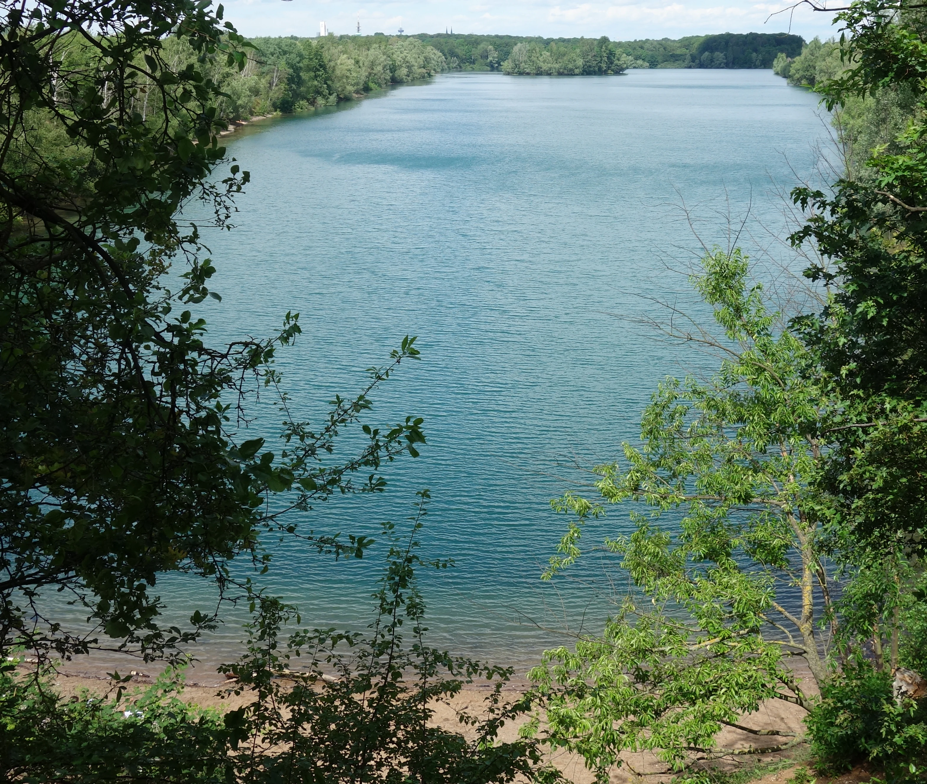
A high-angle view looking down at a calm, blue lake in a nature reserve, framed by dense green tree branches in the foreground.
A view of the Kiesgrubensee Gremberghoven nature reserve, showing the lake and surrounding greenery.

Kiesgrubensee Gremberghoven history and protected-area timeline

The site of Kiesgrubensee Gremberghoven originated as a commercial sand and gravel quarry that was actively worked for many years. Gravel extraction shaped the basin that would later fill with water, leaving behind steep slopes, raw soils, and a large central depression. Operations were shut down in the early 1980s, and the abandoned quarry gradually filled to form the lake that now dominates the reserve.

In 1989, the area was formally designated as a Naturschutzgebiet, a protected nature reserve under the German federal state nature conservation framework. Since then, the site has been managed with conservation goals in mind, including the preservation of the lake as a natural habitat and as a resting area for migratory waterbirds. Fencing, restrictions on fishing and other recreational activities, and removal of waste have been used to limit pressures on the site, while large portions of the slopes have been deliberately left to natural ecological succession.

Kiesgrubensee Gremberghoven landscape and geographic character

The landscape of Kiesgrubensee Gremberghoven is almost entirely shaped by its history as a gravel pit. The dominant feature is the lake itself, a roughly rectangular body of water about 1.5 kilometers long and 600 meters wide, sitting at around 40.5 meters above sea level. A small wooded or low island breaks the surface in the northern part of the basin, adding to the visual character of the site.

Surrounding the water, the terrain consists of narrow sandy and gravelly shore strips that are largely free of vegetation, leading quickly into tall, steep pit slopes. These slopes are the most visually dramatic element of the reserve, particularly on the eastern side, where repeated erosion and collapse have opened up raw soil faces. The southern slopes of the reserve show considerable disturbance from foot traffic, while other areas are distinguished by mature succession with shrubs, mosses, lichens, and pioneer plant cover. The combination of open water, exposed slopes, and a small island gives the reserve a distinctive, almost raw geological feel within an otherwise urban setting.

Kiesgrubensee Gremberghoven ecosystems, habitats, and plant life

Ecologically, Kiesgrubensee Gremberghoven is a textbook example of a post-industrial habitat in transition. The lake is classified as an oligotrophic to mesotrophic calcareous body of water with benthic vegetation dominated by charophyte algae, often referred to as stoneworts or Armleuchteralgen. The surrounding slopes support rare habitat types in a North Rhine-Westphalian context, including sand and gravel extraction sites, raw soil communities, and early successional shrub vegetation.

Because the shoreline is steep and mostly lacks shallow margins, classic reed belts and flat-water habitats are largely absent. Instead, the system's ecological identity rests on its open water, exposed raw soils, and pioneer plant communities. Plant species recorded in the reserve include aquatic forms such as various pondweeds, horned pondweed, hornwort, and water milfoil, alongside terrestrial pioneer species such as colt's foot, common St. John's wort, yarrow, common broom, dog rose, and silver birch. These communities reflect the young, dynamic, and mineral-rich character of the gravel pit environment, and they continue to evolve as succession proceeds on the slopes.

Kiesgrubensee Gremberghoven wildlife and species highlights

The wildlife interest at Kiesgrubensee Gremberghoven centers on waterbirds and species that depend on steep, exposed soil faces. The lake functions both as a breeding site and as a stopover for migratory waterfowl. Great crested grebes and kingfishers are documented as breeding within the reserve, taking advantage of the quiet water and the vertical outer edges of the pit.

Among the most characteristic breeding species are sand martins, which use the vertical cliff edges and erosion faces along the slopes for their colonial nest burrows. The combination of open water, insect-rich slopes, and sheltered banks makes the reserve particularly attractive to these and other cavity- and cliff-nesting species. Beyond birds, the varied shoreline and slope habitats also support insects and other invertebrates associated with pioneer plant communities, although the public literature on the reserve focuses overwhelmingly on its ornithological importance.

Kiesgrubensee Gremberghoven conservation status and protection priorities

Kiesgrubensee Gremberghoven has been protected as a Naturschutzgebiet since 1989, shortly after gravel extraction on the site was halted. Its conservation significance lies in its role as a refuge for waterbirds, a habitat for pioneer plant communities on raw soils, and a working example of post-industrial rehabilitation in a densely populated metropolitan area.

Key conservation aims include preserving and naturally developing the lake itself, maintaining its value as a resting and feeding biotope for migrating waterbirds, and protecting the slope and island habitats from excessive recreational disturbance. Management measures on the site include fencing sensitive areas, restricting fishing and other leisure activities, removing dumped waste, and allowing large parts of the reserve to develop through natural ecological succession. The presence of pollution and waste input, as well as recreational pressure from visitors in this urban-edge location, are recognized as ongoing threats that the reserve's management plan is designed to address.

Top sights and standout views in Kiesgrubensee Gremberghoven

Kiesgrubensee Gremberghoven's strongest points of distinction are its origin as a former sand and gravel pit, its mature transformation into a protected lake reserve, and the unusual combination of open water, a small island, and raw soil slopes found within a single, compact protected site. The reserve's vertical cliff faces provide rare, in-region breeding grounds for sand martins, and the lake serves as both a breeding site and a stopover for waterbirds such as kingfishers and great crested grebes.

Best time to visit Kiesgrubensee Gremberghoven

The reserve is most rewarding to visit during the warmer months, when waterbird activity around the lake is at its peak and the slopes of the reserve display their full cover of pioneer plants, mosses, and lichens. Spring and early summer are generally favorable for observing breeding bird behavior along the shore and on the island. Autumn can bring migratory waterfowl to the lake as a stopover site. Visitors should keep in mind that access to sensitive zones is restricted and that the protected area is a working nature reserve rather than a fully developed visitor attraction.


Monthly climate preview

Long term representative measurements tracking monthly temperature and precipitation rhythm

Kiesgrubensee Gremberghoven Climate Normals and Annual Temperature Patterns

Representative coordinate records show measured monthly temperature ranges and daily precipitation values spanning the annual cycle at Kiesgrubensee Gremberghoven. Examining the complete twelve month profile provides deeper insight into long term climate averages across the protected area.
Annual mean10 °C
1 °C19 °C
Jan
Feb
Mar
Apr
May13°
Jun17°
Jul19°
Aug19°
Sep15°
Oct10°
Nov
Dec
Warmest month
July

19.2 °C

Coolest month
January

1.3 °C

Wettest month
December

2.6 mm/day

Driest month
April

1.6 mm/day

Park location guide

Geography guide, regional context, and park location map for Kiesgrubensee Gremberghoven

Kiesgrubensee Gremberghoven park geography, regions, and map view in Germany

Understand where Kiesgrubensee Gremberghoven sits in Germany through a broader geographic reading of the surrounding landscape, nearby location context, and its mapped position within the national park landscape.

How Kiesgrubensee Gremberghoven fits into Germany

Germany is a federal republic in Western and Central Europe with a population of over 83 million across sixteen constituent states. It is Europe's largest economy by nominal GDP and a major global exporter and importer. The capital is Berlin, and the country borders Denmark, Poland, Czech Republic, Austria, Switzerland, France, Luxembourg, Belgium, and the Netherlands.

Wider geography shaping Kiesgrubensee Gremberghoven in Germany

Germany is located in Western and Central Europe, spanning 357,022 km². It borders Denmark to the north, Poland and the Czech Republic to the east, Austria and Switzerland to the south, and France, Luxembourg, Belgium, and the Netherlands to the west. The country has coastlines on the Baltic Sea and North Sea to the north, with the Alps located in the southern region.

Map view of Kiesgrubensee Gremberghoven

Use this park location map to pinpoint Kiesgrubensee Gremberghoven in Germany, understand its exact geographic position, and read its mapped placement within the surrounding landscape more clearly.

Pigeon | © OpenStreetMap contributors

Location context for Kiesgrubensee Gremberghoven

North Rhine-Westphalia

Visual reference collection highlighting terrain, gravel pit topography, and waterbird habitats.

Kiesgrubensee Gremberghoven Photos and Protected Area Landscape Scenery

Visual documentation captures the reclaimed gravel pit basin, steep sandy slopes, and open waters of Kiesgrubensee Gremberghoven. Photographic records illustrate the protected terrain, pioneer plant succession, and regional ecology.

A high-angle view looking down at a calm, blue lake in a nature reserve, framed by dense green tree branches in the foreground.

Park atlas

Compare regional nature reserves and reclaimed post industrial lake habitats

Explore Parks Near Kiesgrubensee Gremberghoven and Surrounding Protected Areas

Browse protected areas and wetland reserves located near Kiesgrubensee Gremberghoven to study similar post industrial ecosystems. Examining adjacent regional geography provides deeper context for urban conservation landscapes and wildlife habitats.
A horizontal watercolor painting depicting a gentle, hazy green landscape with rolling hills, a line of trees, and a foreground meadow.
Protected landscapeNorth Rhine-Westphalia
About 2.6 km away#1 closest

Southwest

Naturpark Rheinland: Geography and Protected Area Overview in North Rhine-Westphalia

A complex metropolitan nature park and lake district

Naturpark Rheinland represents a distinct convergence of reclaimed lignite mining landscapes, quiet lowland forests, and floodplain wetlands. Its mapped boundaries reveal a diverse terrain of ridges and river valleys that define the environmental character of the Cologne-Bonn metropolitan region.

Area
1,045 km²
Established
1959
Relief
Upland
Climate
Temperate
Nature reserveNorth Rhine-Westphalia
About 7 km away#2 closest

Southeast

Kiesgrube Wahn Nature Reserve: Mapped Geography and Protected Area Context

Protected landscape within the Bergische Heideterrasse of North Rhine-Westphalia

Kiesgrube Wahn provides a compact, high-value ecological mosaic in Cologne, Germany. This former gravel pit has transitioned into a protected nature reserve, hosting a range of aquatic and woodland environments that support rare plant and animal communities within the regional gravel-pit network.

Area
0.054 km²
Established
1988
Relief
Lowland
Access
Highly restricted
Nature reserveCologne
About 7.7 km away#3 closest

Southeast

Kiesgruben Paulsmaar Nature Reserve: Landscape and Geography in the Cologne Urban Fringe

A managed mosaic of post-industrial gravel pits and wetland habitats.

Kiesgruben Paulsmaar represents a distinct example of urban-edge habitat restoration in western Germany. Located near the border of Cologne, this 24-hectare nature reserve consists of three interconnected water bodies, floodplain forests, and calcareous grasslands. It serves as a regional refuge for biodiversity while documenting the conversion of former industrial land into a functioning wetland ecosystem.

Area
0.247 km²
Established
1991
Relief
Lowland
Climate
Temperate
Watercolor landscape illustration showing a pale river curving through green trees with soft hills in the distance.
Nature reserveNorth Rhine-Westphalia
About 8.5 km away#4 closest

South

Langeler Auwald: A Protected Floodplain Forest in the North Rhine-Westphalia Rhine Corridor

Examining fluvial landscape patterns and riparian forest boundaries

Langeler Auwald functions as a significant nature reserve on the right bank of the Rhine in Cologne, preserving a rare mosaic of willow-poplar floodplain forest. The terrain encompasses periodically flooded gravel shores, nutrient-poor grasslands on flood dikes, and transitional orchard habitats that support a high density of protected species within the urbanized landscape of North Rhine-Westphalia.

Area
0.224 km²
Relief
Lowland
Climate
Temperate
Scope
Terrestrial
A soft watercolor illustration of a serene pond surrounded by gentle green hills and lush shoreline vegetation in a light, pastel color palette.
Nature reserveCologne
About 9.8 km away#5 closest

Southwest

Kiesgruben Meschenich: Geographic Analysis of a Cologne Nature Reserve Landscape

Examining the ecological terrain and mapped gravel-pit habitat network.

Kiesgruben Meschenich offers a distinct study in regional conservation, presenting a complex of excavation lakes, raw gravel substrates, and wetland fringes. This protected area stands as a primary example of how industrial remnants transform into valued ecological hubs, serving as a critical refuge for biodiversity in the densely populated Rhine landscape of North Rhine-Westphalia.

Area
0.265 km²
Established
1991
Relief
Lowland
Scope
Terrestrial
A watercolor illustration showing a landscape with a calm lake surrounded by greenery, small trees, and gently rolling hills in the background.
Nature reserveNordrhein-Westfalen
About 14 km away#6 closest

West

Hürther Waldsee Nature Reserve: Mapped Protected Geography and Reclaimed Mining Landscape

Ecological refuge on the Ville lake plateau of Germany

Examine the boundaries and natural features of Hürther Waldsee, a significant nature reserve in the Nordrhein-Westfalen region. This ten-hectare reclaimed mining lake offers a detailed map of post-industrial ecological recovery, featuring engineered islands, reed beds, and young beech and alder woodlands that define its protected status.

Area
0.106 km²
Established
1988
Relief
Lowland
Access
Moderate access
A horizontal watercolor painting depicting a calm lake surrounded by low, rolling hills and coniferous trees under a soft, pale sky.
Nature reserveNordrhein-Westfalen
About 15 km away#7 closest

Southwest

Heider Bergsee Nature Reserve: Geographic Context and Protected Landscape Map

A recovered lake landscape in the North Rhine-Westphalia region of Germany

Discover the complex geography of Heider Bergsee, a prominent nature reserve and post-mining lake in the Ville region. This area showcases how nutrient-poor water and managed forest edges create a vital ecosystem within North Rhine-Westphalia, providing a distinct study in landscape restoration and protected-area mapping.

Area
0.354 km²
Established
1965
Relief
Lowland
Climate
Temperate
A soft watercolor painting showing a winding river with a lush green island in the middle, surrounded by soft-toned riverbanks and trees.
Nature reserveNorth Rhine-Westphalia
About 15 km away#8 closest

South

Herseler Werth Nature Reserve: Geographic Overview of the Rhine River Island Landscape

A strictly protected riverine refuge in North Rhine-Westphalia

Herseler Werth represents a unique study in protected geography as the only non-publicly accessible Rhine island within North Rhine-Westphalia. Spanning 14.8 hectares, this long, narrow river island serves as a critical, human-excluded sanctuary that protects endangered species from industrial and urban disturbance. Its mapped boundaries and poplar-covered terrain illustrate the complex interaction between historical river hydrology and modern conservation efforts along the busy Bonn-Cologne corridor.

Area
0.148 km²
Established
1993
Relief
Lowland
Climate
Temperate

Common questions about visiting, size, designation, and location context for Kiesgrubensee Gremberghoven

Kiesgrubensee Gremberghoven FAQs for park facts, access, geography, and protected area context

Find quick answers about Kiesgrubensee Gremberghoven, including protected-area facts, park geography, trail and visitor context, and how the park fits into its surrounding country and regional landscape.
MoriAtlas Explorer

Continue Your Protected Areas Search Across the Global Atlas

Deepen your exploration by continuing the structured search for national parks and protected areas worldwide. Utilize the comprehensive filtering capabilities to compare different conservation landscapes and refine your understanding of global park geography. Discover more about the distribution and characteristics of protected natural areas.

Global natural geography