

Mori Atlas logo
Nature reserveKigosi National Park

Discover the mapped boundaries and geographic context of this East African nature reserve.

Kigosi National Park Nature Reserve: A Distinct Protected Landscape in Tanzania

Kigosi National Park in Tanzania stands as a significant nature reserve, offering a unique focus for atlas-driven exploration of protected landscapes. This page details its specific geographic setting within East Africa, highlighting its role as a protected area and providing context for its mapped boundaries. Users can delve into the park's distinct landscape identity, understanding its place within the broader regional geography of Tanzania for a structured discovery experience.

WetlandsRamsar SiteMiombo WoodlandsBirdwatchingFloodplainsLarge Mammals

Kigosi National Park

Nature reserve

Park overview

Structured park overview, official facts, and landscape profile for Kigosi National Park

Kigosi National Park park facts, protected area profile, and essential visitor context
Review the core facts for Kigosi National Park, including designation, size, terrain, visitor scale, habitats, and operating context in one park-focused overview.

About Kigosi National Park

Kigosi National Park occupies a remarkable position within Tanzania's protected area network as the northeastern gateway to one of East Africa's most ecologically significant wetland systems. The Moyowosi-Malagarasi complex, spanning nearly 92,000 square kilometers, surpasses in size the entire territory of Portugal and stands as the largest wetlands system in the region. This vast hydrographic network centers on seven major rivers that meander through an intricate landscape of permanent and seasonal marshes, floodplain lakes, and extensive Miombo woodland. The park's designation evolved from its origins as a game reserve in 1983 to national park status in 2019, reflecting its growing conservation significance, though administrative designation subsequently shifted to forest reserve status. The wetland system drains into Lake Tanganyika via the Malagarasi River, with the park's conservation status directly influencing the ecological health of this Great Lake's watershed. The landscape features distinctive floating islands of palm and papyrus that dot numerous lakes and marshes, creating a visually striking environment unique among East African protected areas.

Quick facts and research context for Kigosi National Park

Kigosi occupies a strategic position within the Moyowosi-Malagarasi wetland complex, one of East Africa's most extensive freshwater systems spanning nearly 92,000 square kilometers. The protected area encompasses seven major river systems including the Malagarasi, Moyowosi, Nikonga, Ugalla, Kigosi, and Gombe, which weave through a landscape of marshes, seasonal floodplains, and woodland. Annual rainfall ranges between 1,000 and 1,500 millimeters with bimodal precipitation peaks in February and November, supporting the wetland's sustained ecological function. The region provides habitat for some of Africa's most notable wildlife concentrations, including the largest populations of shoebill storks, wattled cranes, and pygmy geese on the continent, alongside diverse large mammal communities.

Park context

Deeper park guide and search-rich context for Kigosi National Park

Kigosi National Park history, landscape, wildlife, and travel context
Explore Kigosi National Park through its history, landscape character, ecosystems, wildlife, conservation priorities, cultural context, and seasonal travel timing in a structured park guide built for atlas discovery and search intent.

Why Kigosi National Park stands out

Kigosi National Park is best known for its extraordinary wetland ecosystems that form the heart of East Africa's largest inland water system. The Moyowosi-Malagarasi complex represents a biodiversity hotspot of continental significance, supporting the densest populations of specialized waterbirds in Africa, including the iconic shoebill stork and the graceful wattled crane. The park's extensive floodplains and marshlands provide critical refuge for migratory waterfowl and serve as essential dry-season habitat for elephant, buffalo, and various antelope species. The wetland's role in provisioning roughly thirty percent of Lake Tanganyika's freshwater and its Ramsar designation further underscore its ecological importance at a regional and global scale.

Kigosi National Park history and protected-area timeline

The protected area that encompasses Kigosi originated as the Kigosi Game Reserve in 1983, established during a period when Tanzania was expanding its network of wildlife conservation zones. The reserve served initially as a protected habitat for wildlife and as a buffer for the extensive wetland ecosystem. In 2019, the protection status was elevated to national park, acknowledging the area's exceptional ecological value and its importance within the broader Moyowosi-Malagarasi wetlands complex. This upgrade reflected growing recognition of the wetlands' international significance, particularly following Ramsar designation that formally recognized the area as a wetland of worldwide importance. More recently, administrative jurisdiction shifted to the Tanzania Forest Services Agency, with the designation changing to National Forest Reserve while retaining protection under the national parks framework. The park's evolution reflects Tanzania's adaptive approach to managing complex multi-use landscapes where wildlife conservation intersects with broader environmental stewardship goals.

Kigosi National Park landscape and geographic character

The physical landscape of Kigosi is defined by an extensive network of wetlands, floodplains, and woodlands that create one of East Africa's most distinctive protected environments. The terrain is characterized by flat to gently undulating plains punctuated by scattered rocky outcrops and isolated hills that break the horizon across the vast wetland expanse. The seven major rivers that traverse the area, including the Moyowosi, Nikonga, Ugalla, Malagarasi, Kigosi, and Gombe, follow meandering courses through the landscape, creating complex patterns of permanent water channels, seasonal flood zones, and isolated marsh basins. Extensive areas of Miombo woodland, dominated by Brachystegia and Julbernardia species, surround the wetland cores and cover much of the higher ground between water bodies. The floodplains feature characteristic palm-studded grasslands and floating islands of papyrus vegetation that provide critical habitat for specialized wildlife species. During the wet seasons, vast areas become temporarily inundated, transforming the landscape into a connected water network that supports seasonal migrations of wildlife and waterfowl.

Kigosi National Park ecosystems, habitats, and plant life

The ecological character of Kigosi centers on its extensive wetland habitats that support exceptional biodiversity within the East African context. The Ramsar-designated Moyowosi-Malagarasi complex represents a wetland system of international significance, providing critical ecosystem services including water filtration, flood regulation, and carbon sequestration. The park's position at the northeastern edge of this wetland system places it at the confluence of river systems where Nikonga joins the Moyowosi wetlands, creating a zone of exceptional ecological diversity. The Miombo woodland ecosystem that dominates surrounding areas supports distinct plant communities adapted to the region's seasonal rainfall patterns. The floodplain environments contain specialized vegetation adapted to periodic inundation, including floating mats of papyrus and emergent aquatic plants that create intricate habitat structures. The system supports significant populations of water-dependent species and serves as a critical refuge during dry seasons when surrounding upland areas become less hospitable.

Kigosi National Park wildlife and species highlights

Kigosi supports remarkable wildlife populations, with particular significance attributed to its waterbird communities that represent some of the highest concentrations in Africa. The park holds the continent's largest populations of shoebill storks, those distinctive large wading birds with massive bill adaptations suited for hunting lungfish in shallow waters, as well as impressive congregations of wattled cranes, Africa's largest crane species. The wetlands support the largest African populations of pygmy geese, small ducks that specialize in aquatic vegetation, and maintain the highest densities of African clawless otters on the continent. Large mammal communities include substantial populations of African buffalo, elephant, and various antelope species including topi, sable, roan, and the elusive sitatunga that finds ideal habitat in the swampy southern regions. Lion and leopard maintain viable populations within the Miombo woodlands that fringe the wetlands, while hippos and crocodiles inhabit the deeper water channels. The floodplains attract seasonal concentrations of migratory waterfowl and provide crucial dry-season foraging grounds for species including zebra, wildebeest, and herds of buffalo that move into the wetland margins as upland water sources diminish.

Kigosi National Park conservation status and protection priorities

Kigosi occupies a critical position within regional conservation frameworks, with the broader Moyowosi-Malagarasi wetlands designated as a Ramsar site recognizing its international importance as a wetland ecosystem. The wetland system provides essential ecosystem services that extend far beyond its boundaries, including the provisioning of approximately thirty percent of Lake Tanganyika's freshwater inflow, making it a keystone component of the lake's hydrological cycle. The protection of this wetland complex is essential for maintaining biodiversity patterns that depend on the seasonal flooding regimes and the diverse habitat mosaic of marshes, floodplains, and woodlands. Conservation challenges include managing human-wildlife interactions in a landscape where local communities depend on natural resources, and addressing pressures on wetland habitats from climate variability affecting rainfall patterns. The park's designation history reflects ongoing evaluation of the most effective management approaches for this extensive and ecologically complex landscape.

Kigosi National Park cultural meaning and human context

The Kigosi region sits within a landscape where local communities maintain traditional connections to the wetland environment, though specific indigenous heritage sites or cultural designations are not prominently documented in available sources. The Swahili name Hifadhi ya Msitu wa Taifa ya Kigosi reflects the area's integration within Tanzanian administrative frameworks. The park lies relatively removed from major population centers, with Kahama serving as the nearest urban area, limiting intensive human settlement within the protected zone. Traditional land use patterns in the surrounding regions include pastoral activities and small-scale agriculture, interactions that have shaped the landscape context within which the protected area functions.

Top sights and standout views in Kigosi National Park

Kigosi offers access to one of East Africa's most significant wilderness landscapes, where vast wetlands support extraordinary concentrations of specialized wildlife. The opportunity to observe shoebill storks in their preferred habitat ranks among the premier wildlife experiences available on the continent, while the sight of wattled cranes moving across floodplains provides a distinctive safari encounter. The park's extensive size and relatively low visitor pressure create conditions for authentic wilderness exploration, with the possibility of encountering diverse large mammal species in landscapes that remain substantially unmodified by human development. The Miombo woodland environment offers a contrast to the more famous savanna parks of Tanzania, providing insight into a different ecological community. The wetland system's Ramsar designation underscores its international significance and the importance of its conservation.

Best time to visit Kigosi National Park

The optimal period for visiting Kigosi aligns with the dry season extending from mid-May through mid-October, when reduced rainfall concentrates wildlife around remaining water sources and viewing conditions improve across the floodplain environments. The wet seasons bring renewed flooding that disperses wildlife across wider areas and can limit access to certain regions. The primary rainfall periods occur in February and November, creating seasonal variation in the park's accessibility and character. Wildlife viewing tends to be most productive during the latter dry months when animals congregate near permanent water bodies and the vegetation thins somewhat, improving visibility. The park can be visited year-round, though travelers should anticipate seasonal variations in conditions and plan accordingly.

Park location guide

Geography guide, regional context, and park location map for Kigosi National Park

Kigosi National Park park geography, regions, and map view in Tanzania
Understand where Kigosi National Park sits in Tanzania through a broader geographic reading of the surrounding landscape, nearby location context, and its mapped position within the national park landscape.

How Kigosi National Park fits into Tanzania

Tanzania, officially the United Republic of Tanzania, is a presidential republic in East Africa within the African Great Lakes region. It was formed in 1964 through the unification of Tanganyika and Zanzibar. The country is known for its diverse wildlife, national parks including Serengeti and Ngorongoro, and significant archaeological sites with important hominid fossils.

Wider geography shaping Kigosi National Park in Tanzania

Tanzania is located in East Africa within the African Great Lakes region. It is bordered by Uganda to the northwest, Kenya to the northeast, the Indian Ocean to the east, Mozambique and Malawi to the south, Zambia to the southwest, and Rwanda, Burundi, and the Democratic Republic of the Congo to the west. The country includes the mainland and the Zanzibar Archipelago.

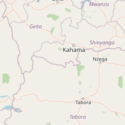
Map view of Kigosi National Park

Use this park location map to pinpoint Kigosi National Park in Tanzania, understand its exact geographic position, and read its mapped placement within the surrounding landscape more clearly.

Pigeon | © OpenStreetMap contributors

Location context for Kigosi National Park

Geita RegionShinyanga RegionTabora Region
Park atlas

Discover surrounding wetland systems, Miombo woodlands, and diverse East African conservation landscapes for broader comparison

Explore Other National Parks and Protected Areas Near Kigosi National Park
After exploring Kigosi National Park's vast wetlands and Miombo woodlands, continue your geographic discovery by browsing other national parks and protected areas across the region. Compare diverse conservation landscapes, map their spread, and understand the interconnected ecosystems that define this unique part of East Africa, offering a deeper atlas-style perspective on regional park geography.
National parkGeita Region

Rubondo Island National Park: Tanzanian National Park Geography and Mapped Boundaries

Explore the protected landscape within Geita Region.

Delve into the protected landscape of Rubondo Island National Park, a designated national park situated in Tanzania's Geita Region. This page provides essential geographic context, detailing the park's mapped boundaries and its contribution to the regional atlas. Understanding Rubondo Island National Park involves exploring its specific terrain and its significance as a protected natural area within the broader landscape.

Area
456.8 km²
Established
1965
IUCN
II
Visitors
1.5K annual
National parkBurundi

Ruvubu National Park: A National Park in Burundi Focused on Protected Landscape Geography

Explore the mapped boundaries and regional context of Ruvubu.

Investigate Ruvubu National Park, a protected natural area in Burundi, and understand its geographic significance. This page serves as a detailed atlas entry, highlighting the park's mapped extent and its contribution to the regional landscape of East Africa. Explore the protected-area context and geographical features that define Ruvubu National Park for discovery and analysis.

Area
508 km²
Established
1980
IUCN
II
Relief
Mixed relief
National parkTanzania

Burigi-Chato National Park: Protected Landscape Atlas Entry for Tanzania

Explore the mapped geography and terrain of this Tanzanian national park.

Burigi-Chato National Park serves as a distinct protected area within Tanzania, detailed here for its geographic significance and atlas exploration value. Users can delve into the park's specific landscape characteristics, its protected boundaries, and its regional setting. This content is designed to support a deeper understanding of conservation lands and natural terrain within the East African context, offering a factual entry point for detailed geographic discovery.

Area
4,707 km²
Established
2019
IUCN
II
Relief
Mixed relief
National parkMwanza Region

Saanane Island National Park: Tanzania National Park with Mapped Protected Landscape Identity

Discover its geographic context within Mwanza Region and atlas exploration value.

Saanane Island National Park represents a key protected area within the Mwanza Region of Tanzania. This detailed entry focuses on its identity as a national park, emphasizing its mapped boundaries and geographic presence. It's designed for users seeking a structured understanding of its landscape context and its place within a broader atlas of protected natural areas, offering factual, geography-focused discovery.

Area
2.8 km²
Established
2013
IUCN
II
Visitors
5.3K annual
National parkTabora Region

Ugalla River National Park: A Tanzania National Park for Geographic Discovery

Explore protected area boundaries and regional landscape context.

Ugalla River National Park serves as a key protected area within Tanzania, specifically situated in the Tabora Region. This page provides essential geographic context, detailing its mapped boundaries and its significance as a national park. It’s designed for users seeking structured information about protected landscapes and their placement within regional geography, offering a factual basis for atlas exploration.

Area
3,865 km²
Established
2019
IUCN
II
Relief
Upland
National parkEastern Province

Akagera National Park National Park: Protected Landscape Geography and Atlas Exploration

Understand the mapped terrain and regional context of Akagera National Park.

Akagera National Park, designated as a national park, represents a vital protected landscape within Rwanda's Eastern Province. This atlas-focused entry provides essential geographic context, highlighting the park's mapped boundaries and natural terrain. Explore Akagera National Park as a key element in regional geography and a focal point for understanding protected land distribution.

Area
1,122 km²
Established
1934
Visitors
34K annual
Relief
Mixed relief
National parkBurundi

Kibira National Park: Burundi's Protected National Park Landscape and Geography

Mapped protected area within the Great Rift Valley region.

Kibira National Park represents a vital protected national park entity within Burundi's diverse geography. As part of the Great Rift Valley's expanse, its mapped boundaries and landscape identity offer a focal point for understanding regional protected areas. This park's presence in Burundi contributes essential data to a structured atlas of natural landscapes and conservation lands across East Africa.

Area
400 km²
IUCN
II
Relief
Mountain
Climate
Tropical
National parkBurundi

Rusizi National Park: National Park in Burundi's Geographic Landscape Context

Explore mapped protected area boundaries and regional geography.

Rusizi National Park stands as a significant protected area within Burundi, contributing to the nation's conservation atlas. This national park offers a distinct geographic profile, showcasing its specific landscape and terrain features within the East African context. Users can delve into the mapped boundaries of Rusizi National Park to understand its protected status and its role in the regional geography, facilitating detailed geographic discovery.

Area
90 km²
Established
1980
IUCN
II
Climate
Tropical

Common questions about visiting, size, designation, and location context for Kigosi National Park

Kigosi National Park FAQs for park facts, access, geography, and protected area context
Find quick answers about Kigosi National Park, including protected-area facts, park geography, trail and visitor context, and how the park fits into its surrounding country and regional landscape.
MoriAtlas Explorer

Continue Your Protected Areas Search Across the Global Atlas

Deepen your exploration by continuing the structured search for national parks and protected areas worldwide. Utilize the comprehensive filtering capabilities to compare different conservation landscapes and refine your understanding of global park geography. Discover more about the distribution and characteristics of protected natural areas.

Global natural geography
