

Mori Atlas logo
National parkRuvubu National Park

Discover the geographic extent and mapped boundaries of this protected natural landscape in Burundi.

Ruvubu National Park: Burundi's National Park for Protected Landscape Discovery and Atlas Exploration

(Parc National de la Ruvubu)

Ruvubu National Park represents a key protected natural area within Burundi, situated in the diverse East African geography. This page offers an atlas-driven perspective, detailing the park's mapped boundaries and its role as a protected landscape. Understand the regional context and geographic setting of Ruvubu National Park, providing a foundational view for exploring its natural terrain and conservation significance within the country.

grassland ecosystemriver valleywetland habitatlarge mammalsprimatesbirdwatching

Ruvubu National Park

National park

Park overview

Structured park overview, official facts, and landscape profile for Ruvubu National Park

Ruvubu National Park park facts, protected area profile, and essential visitor context

Review the core facts for Ruvubu National Park, including designation, size, terrain, visitor scale, habitats, and operating context in one park-focused overview.

About Ruvubu National Park

Ruvubu National Park occupies a significant position in Burundi's protected area network as the nation's largest national park. The park's territory spans across four provinces, creating a protected corridor that extends to the border with Tanzania to the south. The Ruvubu River serves as the ecological backbone of the park, with its valley system shaping the distribution of habitats and wildlife throughout the protected area. The grassland ecosystem that the park protects represents an increasingly rare landscape type in East Africa, where agricultural expansion has converted much of the original grassland habitat. This makes Ruvubu particularly valuable from a conservation perspective, as it preserves both the physical landscape and the ecological processes associated with this habitat type. The park's designation as a Ramsar Wetland in 2013 reflects its international significance, particularly for the wetland habitats associated with the Ruvubu River and its floodplain systems.

Quick facts and research context for Ruvubu National Park

Ruvubu National Park covers 508 square kilometers in northeastern Burundi, encompassing portions of Karuzi, Muyinga, Cankuzo, and Ruyigi provinces. The park was established in 1980 and is governed by the Office Burundais pour la Protection de l'Environnement. The Ruvubu River traverses the park from north to south, creating a broad valley that dominates the landscape. The park represents the final preserved tract of the natural grassland ecosystem that once dominated the northeast region of Burundi. In 2013, the park received Ramsar Wetland designation, acknowledging its significance as a protected wetland habitat.

Protection and recognition

Documenting terrestrial protection scope and global conservation designations.

Ruvubu National Park Protection Status and Official Ramsar Designation

Geographic records trace the official terrestrial protection status and documented Ramsar wetland designation for Ruvubu National Park. Accessing verified designation data assists researchers and conservationists in mapping global ecological networks and understanding regional environmental policy.

International recognition

Protection details

Protection scope
Terrestrial
Transboundary protection
No
Park context

Deeper park guide and search-rich context for Ruvubu National Park

Ruvubu National Park history, landscape, wildlife, and travel context

Explore Ruvubu National Park through its history, landscape character, ecosystems, wildlife, conservation priorities, cultural context, and seasonal travel timing in a structured park guide built for atlas discovery and search intent.

Why Ruvubu National Park stands out

Ruvubu National Park is best known for its role as the last remaining example of the natural grassland ecosystem that once covered northeast Burundi. The park's extensive river valley, carved by the Ruvubu River, creates a distinctive landscape characterized by floodplains, wetlands, and rolling grassland terrain. The park supports significant populations of large mammals including hippopotamus, Nile crocodile, Cape buffalo, and waterbuck. Its primate diversity is notable, with five species recorded including olive baboon, vervet monkey, red colobus monkey, blue monkey, and Senegal bushbaby. The area also hosts approximately 200 bird species, making it an important bird habitat in the region.

Ruvubu National Park history and protected-area timeline

Ruvubu National Park was established in 1980 as part of Burundi's effort to create a comprehensive national protected area network. The park was created to preserve the remaining examples of the country's natural grassland ecosystems and the associated wildlife populations. In March 2013, the park received additional recognition through its designation as a Ramsar Wetland, placing it under the international framework for the protection of significant wetland habitats. The Office Burundais pour la Protection de l'Environnement serves as the governing body responsible for managing the park's conservation and protection activities. The establishment of the park represented a recognition that the grassland ecosystem of northeast Burundi required dedicated protection to prevent further loss of this habitat type.

Ruvubu National Park landscape and geographic character

The landscape of Ruvubu National Park is dominated by the valley of the Ruvubu River, which flows through the length of the protected area from north to south. The river valley creates a broad floodplain system that spans considerable width, flanked by rolling grassland terrain that extends toward the surrounding provinces. The topography is characterized by relatively gentle slopes and open terrain, distinguishing this park from the more mountainous protected areas found in other parts of Burundi. The grassland ecosystem forms the dominant vegetation type across most of the park, with the river corridor providing a different habitat character through its wetland and riparian zones. The park's location in northeastern Burundi places it in a region where the landscape transitions between the highland areas of central Burundi and the lower-lying territories extending toward Lake Victoria and Tanzania.

Ruvubu National Park ecosystems, habitats, and plant life

Ruvubu National Park protects one of the last remaining examples of the natural grassland ecosystem that historically covered the northeast region of Burundi. The park's ecological character is shaped by the Ruvubu River system, which creates a complex of wetland habitats including floodplains, marshes, and riparian zones alongside the more extensive grassland areas. This combination of terrestrial and wetland habitats supports a diverse range of ecological communities. The grassland habitat type has become increasingly scarce in the region due to agricultural conversion, making the park's preservation of this ecosystem particularly significant. The river and its associated wetlands provide critical habitat for water-dependent species and contribute to the overall biodiversity value of the protected area.

Ruvubu National Park wildlife and species highlights

Ruvubu National Park supports diverse wildlife populations across its grassland and wetland habitats. Large mammals are well represented, with hippopotamus and Nile crocodile found along the Ruvubu River corridor, while Cape buffalo and waterbuck graze the grassland areas. Several duiker species inhabit the park's diverse habitats. The primate community is notably diverse, with five species recorded: olive baboon, vervet monkey, red colobus monkey, blue monkey, and Senegal bushbaby. This primate diversity reflects the variety of habitats within the park, from forest patches along the river to more open woodland and grassland areas. The park's bird population includes approximately 200 species, making it an important area for avian conservation in Burundi. The combination of grassland, wetland, and river habitats creates conditions that support both resident species and migratory populations.

Ruvubu National Park conservation status and protection priorities

Ruvubu National Park holds significant conservation value as the last vestige of the natural grassland ecosystem that once covered the northeast of Burundi. The park's 2013 designation as a Ramsar Wetland acknowledges its international importance as a protected wetland area under the Ramsar Convention. This recognition reflects the ecological significance of the Ruvubu River system and its associated floodplain habitats, which provide critical ecosystem services and wildlife habitat. The park serves as a refuge for species that depend on grassland and wetland environments, many of which have lost habitat elsewhere in the region due to agricultural expansion and human development. Conservation of this area is essential for maintaining the biological diversity of northeastern Burundi and preserving ecological processes associated with these increasingly rare habitat types.

Ruvubu National Park cultural meaning and human context

Ruvubu National Park is located in a region of Burundi with traditional pastoral and agricultural land use patterns. The park's name derives from the Ruvubu River, which holds local significance as a major watercourse in the northeastern part of the country. While the park itself does not contain major cultural heritage sites, the surrounding provinces have been inhabited for generations, with local communities maintaining traditional relationships with the land and resources of this region. The park's establishment in 1980 created a protected area that coexists with these surrounding land use patterns, requiring management approaches that balance conservation objectives with the needs of local communities.

Top sights and standout views in Ruvubu National Park

The Ruvubu River valley forms the central geographic feature of the park, creating a distinctive landscape of floodplains and wetlands that supports abundant wildlife. The park represents the last remnant of Burundi's northeast grassland ecosystem, making it a critical area for conservation of this increasingly rare habitat type. The primate community of five species, including red colobus and blue monkeys, demonstrates the ecological diversity contained within the park. The approximately 200 bird species recorded in the park make it an important destination for birdwatching and avian study. The Ramsar Wetland designation in 2013 reflects the international recognition of the park's wetland conservation value.

Best time to visit Ruvubu National Park

The best time to visit Ruvubu National Park corresponds with the dry seasons, which typically run from June to September and December to February. During these periods, wildlife tends to concentrate around the remaining water sources along the river corridor, making animal viewing more predictable. The wet seasons bring renewed vegetation growth across the grasslands and can make some areas less accessible, though they also bring the birding opportunities associated with migratory species. The park's accessible location near the town of Muyinga provides a convenient base for visits, though visitors should be prepared for the basic infrastructure that characterizes many of Burundi's protected areas.

Monthly climate preview

Long term weather by month patterns mapped at a representative park elevation of 1485 meters

Monthly Climate Normals and Average Temperatures for Ruvubu National Park

Long term climatology reveals steady average monthly temperatures between 19 and 22 degrees Celsius, accompanied by a distinct dry cycle with very low daily rainfall in July. Accessing the complete monthly profile allows for a detailed comparison of daily temperature boundaries and seasonal precipitation fluctuations throughout the year.
Annual mean21 °C
19 °C22 °C
Jan21°
Feb21°
Mar21°
Apr20°
May20°
Jun19°
Jul19°
Aug21°
Sep22°
Oct22°
Nov20°
Dec20°
Warmest month
September

22.2 °C

Coolest month
July

19.4 °C

Wettest month
November

6.3 mm/day

Driest month
July

0.3 mm/day

Park location guide

Geography guide, regional context, and park location map for Ruvubu National Park

Ruvubu National Park park geography, regions, and map view in Burundi

Understand where Ruvubu National Park sits in Burundi through a broader geographic reading of the surrounding landscape, nearby location context, and its mapped position within the national park landscape.

How Ruvubu National Park fits into Burundi

Burundi is a landlocked East African country with a population of over 14 million people. Located in the Great Rift Valley, it borders Rwanda to the north, Tanzania to the east and southeast, and the Democratic Republic of the Congo to the west. Lake Tanganyika lies along its southwestern border. The capital is Gitega and the largest city is Bujumbura.

Wider geography shaping Ruvubu National Park in Burundi

Burundi is located in East Africa in the Great Rift Valley region, at the junction between the African Great Lakes area and Southeast Africa. It is landlocked and borders Rwanda to the north, Tanzania to the east and southeast, and the Democratic Republic of the Congo to the west. Lake Tanganyika lies along its southwestern border, providing access to major waterways.

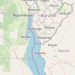
Map view of Ruvubu National Park

Use this park location map to pinpoint Ruvubu National Park in Burundi, understand its exact geographic position, and read its mapped placement within the surrounding landscape more clearly.

Pigeon | © OpenStreetMap contributors

Location context for Ruvubu National Park

CankuzoKaruziMuyingaRuyigi
Recorded earthquake history

Examine the Seismic Activity History for Ruvubu National Park

Review the curated list of recorded earthquakes associated by proximity with Ruvubu National Park. This MoriAtlas collection provides transparent access to historical event data, allowing for a clearer understanding of the seismic context surrounding this protected river valley landscape.

Ruvubu National Park Earthquake History

Catalogued events

3 events

Strongest magnitude

Magnitude 4.8

Most recent event

May 21, 2015

This history includes earthquakes recorded inside the park or within 50 km of its borders

Park atlas

Map the Regional Spread of Protected Landscapes and Compare East African Conservation Efforts

Explore Other National Parks and Protected Areas Around Ruvubu National Park

Continue your exploration beyond Ruvubu National Park by browsing a curated list of nearby protected areas, including additional grassland ecosystems, river valleys, and vital wetland habitats across the East African geography. Comparing these diverse conservation landscapes provides valuable context for understanding regional biodiversity, unique terrain features, and the interconnected network of protected zones.
National parkBurundi
About 87 km away#1 closest

West

Kibira National Park: Burundi's Protected National Park Landscape and Geography

Mapped protected area within the Great Rift Valley region.

Kibira National Park represents a vital protected national park entity within Burundi's diverse geography. As part of the Great Rift Valley's expanse, its mapped boundaries and landscape identity offer a focal point for understanding regional protected areas. This park's presence in Burundi contributes essential data to a structured atlas of natural landscapes and conservation lands across East Africa.

Area
400 km²
IUCN
II
Relief
Mountain
Climate
Tropical
National parkBurundi
About 96 km away#2 closest

West

Rusizi National Park: National Park in Burundi's Geographic Landscape Context

Explore mapped protected area boundaries and regional geography.

Rusizi National Park stands as a significant protected area within Burundi, contributing to the nation's conservation atlas. This national park offers a distinct geographic profile, showcasing its specific landscape and terrain features within the East African context. Users can delve into the mapped boundaries of Rusizi National Park to understand its protected status and its role in the regional geography, facilitating detailed geographic discovery.

Area
90 km²
Established
1980
IUCN
II
Climate
Tropical
National parkTanzania
About 99 km away#3 closest

Northeast

Burigi-Chato National Park: Protected Landscape Atlas Entry for Tanzania

Explore the mapped geography and terrain of this Tanzanian national park.

Burigi-Chato National Park serves as a distinct protected area within Tanzania, detailed here for its geographic significance and atlas exploration value. Users can delve into the park's specific landscape characteristics, its protected boundaries, and its regional setting. This content is designed to support a deeper understanding of conservation lands and natural terrain within the East African context, offering a factual entry point for detailed geographic discovery.

Area
4,707 km²
Established
2019
IUCN
II
Relief
Mixed relief
National parkRwanda
About 129 km away#4 closest

Northwest

Nyungwe Forest National Park: Protected Landscape in Rwanda's Geography

National park mapping and regional context discovery.

Understand Nyungwe Forest National Park as a distinct protected landscape within the atlas of Rwanda. This page details its status as a national park, focusing on its geographic positioning and mapped protected boundaries. Explore the park's integral role in the regional geography of East Africa, providing a foundation for structured discovery of its natural terrain and conservation importance.

National parkRwanda
About 129 km away#5 closest

Northwest

Nyungwe National Park: Rwanda's Protected National Park for Geographic Discovery

Explore its mapped natural landscape and protected terrain.

Nyungwe National Park represents a vital protected area within Rwanda, contributing a unique landscape to the nation's geographic atlas. This national park offers a specific focus for understanding protected lands, their mapped boundaries, and the natural terrain they encompass. By examining Nyungwe National Park, users gain insight into Rwanda's regional geography and the significance of its conservation efforts within the broader context of East African natural landscapes.

National parkEastern Province
About 146 km away#6 closest

North

Akagera National Park National Park: Protected Landscape Geography and Atlas Exploration

Understand the mapped terrain and regional context of Akagera National Park.

Akagera National Park, designated as a national park, represents a vital protected landscape within Rwanda's Eastern Province. This atlas-focused entry provides essential geographic context, highlighting the park's mapped boundaries and natural terrain. Explore Akagera National Park as a key element in regional geography and a focal point for understanding protected land distribution.

Area
1,122 km²
Established
1934
Visitors
34K annual
Relief
Mixed relief
National parkTanzania
About 155 km away#7 closest

Southwest

Gombe Stream National Park: Tanzania National Park Mapped Boundaries and Geography

Explore protected landscape identity and regional context.

Gombe Stream National Park is a vital protected area offering a specific geographic focus for atlas-based discovery. Users can examine its mapped boundaries and understand its position within Tanzania's diverse regional geography. This page serves as a canonical entry for comprehending the park's identity as a national park and its contribution to the conservation landscape data, providing essential context for geographic exploration.

National parkGeita Region
About 161 km away#8 closest

Northeast

Rubondo Island National Park: Tanzanian National Park Geography and Mapped Boundaries

Explore the protected landscape within Geita Region.

Delve into the protected landscape of Rubondo Island National Park, a designated national park situated in Tanzania's Geita Region. This page provides essential geographic context, detailing the park's mapped boundaries and its contribution to the regional atlas. Understanding Rubondo Island National Park involves exploring its specific terrain and its significance as a protected natural area within the broader landscape.

Area
456.8 km²
Established
1965
IUCN
II
Visitors
1.5K annual

Common questions about visiting, size, designation, and location context for Ruvubu National Park

Ruvubu National Park FAQs for park facts, access, geography, and protected area context

Find quick answers about Ruvubu National Park, including protected-area facts, park geography, trail and visitor context, and how the park fits into its surrounding country and regional landscape.
MoriAtlas Explorer

Continue Your Protected Areas Search Across the Global Atlas

Deepen your exploration by continuing the structured search for national parks and protected areas worldwide. Utilize the comprehensive filtering capabilities to compare different conservation landscapes and refine your understanding of global park geography. Discover more about the distribution and characteristics of protected natural areas.

Global natural geography
