Mori Atlas logo
National parkRusizi National Park

Discover the mapped geography and protected area context of Rusizi National Park.

Rusizi National Park: National Park in Burundi's Protected Landscape Atlas

(Parc National de la Rusizi)

Rusizi National Park represents a key protected landscape within Burundi, situated in the Great Rift Valley region of East Africa. As a national park, it offers a unique entry point for exploring its mapped boundaries and the surrounding natural terrain. This dedicated page provides essential geographic context for understanding Rusizi National Park's place within the country's conservation network and its broader atlas representation.

wetlandhippopotamusRamsar siteriver ecosystemGreat Lakespapyrus swamp

Rusizi National Park

National park

Park overview

Structured park overview, official facts, and landscape profile for Rusizi National Park

Rusizi National Park park facts, protected area profile, and essential visitor context

Review the core facts for Rusizi National Park, including designation, size, terrain, visitor scale, habitats, and operating context in one park-focused overview.

About Rusizi National Park

Rusizi National Park occupies a strategically important position in Burundi's protected area network as the country's primary wetland conservation site. The park encompasses the lower reaches of the Rusizi River as it navigates through a flat, low-lying floodplain before emptying into Lake Tanganyika, Africa's second-deepest lake. This positioning creates a distinctive mosaic of aquatic habitats including permanent river channels, seasonal flood zones, papyrus-dominated swamps, and marginal wetlands that maintain water throughout the year. The ecosystem supports remarkable biodiversity despite its relatively modest area, functioning as a refuge for species that depend on permanent freshwater environments in a region where such habitats are limited. The park's accessibility from Bujumbura, located just 15 kilometers to the south, makes it a potential destination for visitors interested in experiencing Burundi's natural heritage, though tourism infrastructure remains limited. The Rusizi River itself forms part of the boundary between Burundi and the Democratic Republic of the Congo to the north, adding geopolitical significance to the protected area.

Quick facts and research context for Rusizi National Park

Rusizi National Park occupies a low-elevation floodplain at the mouth of the Rusizi River where it enters Lake Tanganyika. The park covers roughly 90 square kilometers and was established in 1980 under Burundi's protected area framework. It holds Ramsar Convention designation as a wetland of international importance, recognized in 2002 for its ecological significance as a freshwater habitat. The park is managed by the Office Burundais pour la Protection de l'Environnement, Burundi's primary environmental protection body. Located in Kirundo Province, the park sits at approximately 3.25 degrees south latitude and 29.23 degrees east longitude.

Protection and recognition

Tracing terrestrial conservation scope and international Ramsar designations since 2002

Documented Protection Status and Ramsar Designation of Rusizi National Park

Geographic datasets verify the terrestrial protection status of Rusizi National Park, reflecting its official designation as a protected landscape in 2002. Global conservation records also document its status as an internationally recognized Ramsar site, offering structured baseline data for regional park exploration.

International recognition

Protection details

Protection scope
Terrestrial
Designated year
2002
Transboundary protection
No
Park context

Deeper park guide and search-rich context for Rusizi National Park

Rusizi National Park history, landscape, wildlife, and travel context

Explore Rusizi National Park through its history, landscape character, ecosystems, wildlife, conservation priorities, cultural context, and seasonal travel timing in a structured park guide built for atlas discovery and search intent.

Why Rusizi National Park stands out

Rusizi National Park is best known for its substantial population of hippopotamuses, which thrive in the park's shallow river channels and swampy floodplains. The park also protects significant herds of sitatunga, a semi-aquatic antelope species adapted to wetland environments. Perhaps most famously, Rusizi has been associated with Gustave, a massive Nile crocodile rumored to have killed as many as 300 people in the area, though this figure remains disputed. The park's Ramsar designation recognizes its importance as a coastal wetland ecosystem at the northern end of Lake Tanganyika, supporting biodiversity that includes numerous bird species, fish populations, and other wildlife dependent on the riverine and swamp habitats.

Rusizi National Park history and protected-area timeline

Rusizi National Park was established in 1980 as part of Burundi's developing national park system during a period when the country sought to formalize protection for its most ecologically significant landscapes. The park's designation reflected growing recognition within Burundi of the need to conserve the Rusizi River floodplain's unique wetland values, which supported populations of large mammals and provided essential ecosystem services to surrounding communities. In 2002, the park received international recognition under the Ramsar Convention, joining a global network of wetlands designated for their international ecological importance, particularly for waterfowl habitat. This Ramsar designation elevated the park's profile and committed Burundi to maintaining the ecological character of the site. Management responsibility rests with the Office Burundais pour la Protection de l'Environnement, the national agency charged with overseeing protected areas and environmental conservation programs throughout the country.

Rusizi National Park landscape and geographic character

The physical landscape of Rusizi National Park is defined by the Rusizi River and its interaction with the low-lying terrain flanking its lower course. The river descends from higher ground to the north and east, depositing sediments as it enters the relatively flat zone near Lake Tanganyika, creating a delta-like environment with multiple distributary channels. Papyrus swamps dominate large areas, their tall stems forming dense stands that rise from waterlogged soils. The landscape is essentially flat, with minimal topographic variation across most of the park's extent, though subtle variations in elevation determine which areas remain permanently flooded versus those that experience seasonal inundation. The interface between the river system and the lake creates a transition zone of particular ecological significance, where freshwater meets the more alkaline waters of Lake Tanganyika.

Rusizi National Park ecosystems, habitats, and plant life

The ecological character of Rusizi National Park centers on its freshwater wetland habitats, which rank among the most productive environments in the Great Lakes region. The papyrus swamps represent the dominant vegetation type, forming extensive stands that provide cover and feeding grounds for numerous species. The river channels and pools support aquatic plant communities and provide critical water access for large mammals. Water quality in the Rusizi system, while facing challenges from agricultural runoff and human settlement in the catchment, remains sufficient to sustain diverse aquatic communities including fish species that move between the river and lake. The wetland system plays an important role in water filtration and flood regulation for downstream areas, providing ecosystem services that extend beyond the park's boundaries.

Rusizi National Park wildlife and species highlights

Rusizi National Park supports significant populations of large mammals, with hippopotamuses being the most conspicuous residents. These massive herbivores congregate in the river channels and shallow pools, emerging to graze on adjacent grasslands during evening hours. The sitatunga, a specialized wetland antelope with splayed hooves adapted for moving through soft substrates, inhabits the papyrus swamps and represents one of the more sought-after sightings for visitors. The park's crocodile population includes the Nile crocodile, the largest predator in Burundi's freshwater systems. The legendary individual known as Gustave, reported to reach lengths exceeding five meters, has been associated with the Rusizi area for decades and has become something of an emblematic presence despite the uncertainty surrounding exact population numbers. Birdlife is diverse, with waterfowl and wading species particularly well-represented given the wetland habitat.

Rusizi National Park conservation status and protection priorities

The Ramsar designation awarded to Rusizi National Park in 2002 reflects the site's recognized importance as a wetland ecosystem of international significance. This designation specifically recognizes the park's value for waterfowl and other wildlife dependent on wetland habitats, committing Burundi to maintaining the ecological character of the site. The park faces ongoing challenges from human pressure in its surroundings, as population density in the Rusizi River basin remains high and agricultural expansion continues to affect habitat outside protected boundaries. Conservation priorities for the park include maintaining the integrity of the river-floodplain system, ensuring sufficient water quality for aquatic species, and managing the interface between protected areas and agricultural lands to reduce human-wildlife conflict. The Office Burundais pour la Protection de l'Environnement works to balance conservation objectives with the needs of local communities who depend on the river system for fishing and other livelihood activities.

Rusizi National Park cultural meaning and human context

The Rusizi River holds significance for communities along its banks, with fishing providing important supplementary income for rural populations in the region. The river also serves as a natural boundary between Burundi and the Democratic Republic of the Congo, adding an international dimension to the management of the protected area. Local communities have historical connections to the floodplain areas, though the specific traditional uses and cultural relationships with the landscape are not extensively documented in available sources. The park's proximity to Bujumbura means that urban residents have historically accessed the area for recreation and resource gathering, creating ongoing interactions between urban populations and the protected ecosystem.

Top sights and standout views in Rusizi National Park

Rusizi National Park offers visitors the opportunity to observe hippos in their natural wetland environment, with large herds often visible from boat excursions on the river channels. The sitatunga, while challenging to spot, represents a special prize for wildlife enthusiasts seeking to observe this specialized wetland antelope. The park's Ramsar designation underscores its ecological importance as a coastal wetland ecosystem supporting diverse species. The dramatic presence of large Nile crocodiles in the river system, particularly the legendary Gustave, adds an element of intrigue to visits. The accessibility of the park from Bujumbura makes it a practical option for those seeking to experience Burundi's natural environment without extensive travel.

Best time to visit Rusizi National Park

The best time to visit Rusizi National Park generally corresponds to the drier months, typically from June through September, when reduced rainfall makes wildlife more concentrated around permanent water sources and access within the park is easier. The wet season, from October through May, brings higher water levels that expand the floodplain but can make some areas less accessible and wildlife more dispersed. Birdwatching opportunities vary seasonally, with migratory waterfowl present during the austral winter months. Visitors should be aware that infrastructure within the park remains limited and that access arrangements may require coordination with park authorities in advance.

Monthly climate preview

Analyzing thirty years of monthly temperature and rainfall averages in Burundi

Rusizi National Park Average Temperatures and Monthly Climate Normals

Representative coordinate data at 1522 meters elevation show consistent annual mean temperatures near 20 degrees Celsius, with rainfall peaking during November. Accessing the complete twelve-month profile reveals a detailed comparison of daily temperature ranges and precipitation trends across the annual cycle.
Annual mean21 °C
19 °C22 °C
Jan21°
Feb21°
Mar21°
Apr21°
May20°
Jun19°
Jul19°
Aug21°
Sep22°
Oct22°
Nov21°
Dec21°
Warmest month
September

21.9 °C

Coolest month
June

19.5 °C

Wettest month
November

8 mm/day

Driest month
July

0.5 mm/day

Park location guide

Geography guide, regional context, and park location map for Rusizi National Park

Rusizi National Park park geography, regions, and map view in Burundi

Understand where Rusizi National Park sits in Burundi through a broader geographic reading of the surrounding landscape, nearby location context, and its mapped position within the national park landscape.

How Rusizi National Park fits into Burundi

Burundi is a landlocked East African country with a population of over 14 million people. Located in the Great Rift Valley, it borders Rwanda to the north, Tanzania to the east and southeast, and the Democratic Republic of the Congo to the west. Lake Tanganyika lies along its southwestern border. The capital is Gitega and the largest city is Bujumbura.

Wider geography shaping Rusizi National Park in Burundi

Burundi is located in East Africa in the Great Rift Valley region, at the junction between the African Great Lakes area and Southeast Africa. It is landlocked and borders Rwanda to the north, Tanzania to the east and southeast, and the Democratic Republic of the Congo to the west. Lake Tanganyika lies along its southwestern border, providing access to major waterways.

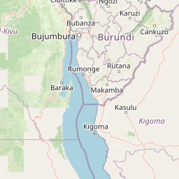
Map view of Rusizi National Park

Use this park location map to pinpoint Rusizi National Park in Burundi, understand its exact geographic position, and read its mapped placement within the surrounding landscape more clearly.

Pigeon | © OpenStreetMap contributors
Park atlas

Explore surrounding Great Lakes region landscapes and compare other significant wetland and riverine protected areas.

Discover Other National Parks and Protected Areas Near Rusizi National Park

Browse a curated list of national parks and protected areas geographically close to Rusizi National Park, covering diverse wetland ecosystems and riverine habitats in the Great Lakes region. Compare their key features, mapped geography, and conservation landscapes to understand the broader East African protected areas connected to Burundi's significant Ramsar site.
National parkBurundi
About 43 km away#1 closest

Northeast

Kibira National Park: Burundi's Protected National Park Landscape and Geography

Mapped protected area within the Great Rift Valley region.

Kibira National Park represents a vital protected national park entity within Burundi's diverse geography. As part of the Great Rift Valley's expanse, its mapped boundaries and landscape identity offer a focal point for understanding regional protected areas. This park's presence in Burundi contributes essential data to a structured atlas of natural landscapes and conservation lands across East Africa.

Area
400 km²
IUCN
II
Relief
Mountain
Climate
Tropical
National parkRwanda
About 84 km away#2 closest

North

Nyungwe Forest National Park: Protected Landscape in Rwanda's Geography

National park mapping and regional context discovery.

Understand Nyungwe Forest National Park as a distinct protected landscape within the atlas of Rwanda. This page details its status as a national park, focusing on its geographic positioning and mapped protected boundaries. Explore the park's integral role in the regional geography of East Africa, providing a foundation for structured discovery of its natural terrain and conservation importance.

National parkRwanda
About 84 km away#3 closest

North

Nyungwe National Park: Rwanda's Protected National Park for Geographic Discovery

Explore its mapped natural landscape and protected terrain.

Nyungwe National Park represents a vital protected area within Rwanda, contributing a unique landscape to the nation's geographic atlas. This national park offers a specific focus for understanding protected lands, their mapped boundaries, and the natural terrain they encompass. By examining Nyungwe National Park, users gain insight into Rwanda's regional geography and the significance of its conservation efforts within the broader context of East African natural landscapes.

National parkBurundi
About 96 km away#4 closest

East

Ruvubu National Park: A National Park in Burundi Focused on Protected Landscape Geography

Explore the mapped boundaries and regional context of Ruvubu.

Investigate Ruvubu National Park, a protected natural area in Burundi, and understand its geographic significance. This page serves as a detailed atlas entry, highlighting the park's mapped extent and its contribution to the regional landscape of East Africa. Explore the protected-area context and geographical features that define Ruvubu National Park for discovery and analysis.

Area
508 km²
Established
1980
IUCN
II
Relief
Mixed relief
Watercolor illustration of a landscape with mountains, water bodies, and grassy fields
National parkDemocratic Republic of the Congo
About 98 km away#5 closest

Northwest

Kahuzi-Biega National Park: Protected Volcanic and Rainforest Landscapes in the Congo

Geographic atlas of the Mitumba Mountains and lowland rainforest transition

Kahuzi-Biega National Park occupies a significant expanse in the eastern Democratic Republic of the Congo, connecting mountainous volcanic terrain with sprawling tropical lowland forests. The area supports an unparalleled diversity of vegetation, tracking from subalpine summits down to rare swamp and riparian habitats. This site acts as a key reference for understanding the ecological richness of the Albertine Rift and the broader Congo Basin landscape.

Area
6,000 km²
Established
1970
IUCN
II
Relief
Mixed relief
National parkSouth Kivu Province
About 101 km away#6 closest

Northwest

Kahuzi-Biéga National Park: Protected Mountain and Rainforest Geography in South Kivu

Mapped terrain from volcanic summits to equatorial forest basins.

Kahuzi-Biéga National Park represents a significant protected area within the South Kivu Province. The geography features two distinct sectors connected by a narrow ecological corridor, encompassing everything from high-altitude subalpine heather zones to dense tropical lowland environments. This dataset provides a detailed look at the park boundaries, volcanic topography, and the regional landscape context that defines this essential habitat.

Area
6,000 km²
Established
1970
IUCN
II
Relief
Mixed relief
National parkTanzania
About 163 km away#7 closest

South

Gombe Stream National Park: Tanzania National Park Mapped Boundaries and Geography

Explore protected landscape identity and regional context.

Gombe Stream National Park is a vital protected area offering a specific geographic focus for atlas-based discovery. Users can examine its mapped boundaries and understand its position within Tanzania's diverse regional geography. This page serves as a canonical entry for comprehending the park's identity as a national park and its contribution to the conservation landscape data, providing essential context for geographic exploration.

National parkWestern Province
About 167 km away#8 closest

North

Gishwati Forest National Park: Discover Rwanda's Protected Landscape Geography

Mapped protected area boundaries and regional natural landscape.

Gishwati Forest National Park offers a focused exploration of a significant protected natural landscape in Rwanda's Western Province. This resource provides detailed geographic context, highlighting the park's mapped boundaries and its role within the country's conservation areas. Understand its terrain and regional landscape importance through an atlas-centric view.

Area
32.02 km²
Established
2015
IUCN
IV
Relief
Mountain

Common questions about visiting, size, designation, and location context for Rusizi National Park

Rusizi National Park FAQs for park facts, access, geography, and protected area context

Find quick answers about Rusizi National Park, including protected-area facts, park geography, trail and visitor context, and how the park fits into its surrounding country and regional landscape.
MoriAtlas Explorer

Continue Your Protected Areas Search Across the Global Atlas

Deepen your exploration by continuing the structured search for national parks and protected areas worldwide. Utilize the comprehensive filtering capabilities to compare different conservation landscapes and refine your understanding of global park geography. Discover more about the distribution and characteristics of protected natural areas.

Global natural geography