

Mori Atlas logo
National parkKilimanjaro National Park

Explore the mapped boundaries and regional landscape context of this national park.

Kilimanjaro National Park: Protected Area Atlas and Geographic Discovery

Kilimanjaro National Park stands as a significant protected area, offering a unique lens into Tanzania's diverse geography. This page provides an atlas-focused exploration of its park boundaries and landscape character, situating it within the Kilimanjaro Region. Discover the geographic context and mapped terrain that define this important natural landscape.

Volcanic mountainWorld Heritage SiteAfrican peakMontane forestAlpine ecosystemsGlacial landscape

Kilimanjaro National Park

National park

Park overview

Structured park overview, official facts, and landscape profile for Kilimanjaro National Park

Kilimanjaro National Park park facts, protected area profile, and essential visitor context
Review the core facts for Kilimanjaro National Park, including designation, size, terrain, visitor scale, habitats, and operating context in one park-focused overview.

About Kilimanjaro National Park

Kilimanjaro National Park sits in northern Tanzania, encompassing the entire bulk of Mount Kilimanjaro above the tree line and the surrounding montane forest ecosystem. The park’s location just south of the equator places it at the intersection of tropical and subtropical climate zones, creating unique environmental conditions that support extraordinary biodiversity. The mountain itself is a dormant volcanic stratovolcano with three volcanic cones: Kibo, Mawenzi, and Shira. Kibo remains the highest point at 5,895 meters and retains permanent ice and glacier fields despite ongoing climate change concerns. The park was formally established in 1973 when the area above approximately 2,700 meters was reclassified from forest reserve to national park status. In 2005, the park boundary was expanded to include the entire montane forest zone that had previously been managed as a separate forest reserve. This expansion recognized the ecological continuity between the forest ecosystem and the higher-elevation alpine zones. The Tanzania National Parks Authority administers the park from headquarters in Marangu, a village at the mountain’s eastern base that serves as the primary staging point for climbers using the Marangu Route.

Quick facts and research context for Kilimanjaro National Park

Kilimanjaro National Park is located in northern Tanzania, about 300 kilometers south of the equator in the Kilimanjaro Region near Moshi town. The park covers 1,688 square kilometers and protects Mount Kilimanjaro above the tree line along with the surrounding montane forest above 1,820 meters. The mountain reaches 5,895 meters at its summit, making it the highest peak in Africa. Administered by the Tanzania National Parks Authority, the park receives approximately 52,000 visitors annually, many of whom attempt to summit the mountain via one of seven official climbing routes.

Park context

Deeper park guide and search-rich context for Kilimanjaro National Park

Kilimanjaro National Park history, landscape, wildlife, and travel context
Explore Kilimanjaro National Park through its history, landscape character, ecosystems, wildlife, conservation priorities, cultural context, and seasonal travel timing in a structured park guide built for atlas discovery and search intent.

Why Kilimanjaro National Park stands out

Kilimanjaro National Park is best known as the site of Mount Kilimanjaro, Africa’s highest mountain and one of the world’s most iconic peaks. The mountain’s snow-capped summit and dramatic vertical profile make it a bucket-list destination for mountaineers and adventurers. Beyond its climbing appeal, the park protects a remarkable sequence of ecological zones, from dense montane forest through heath and moorland to alpine desert and glacial ice. The combination of accessibility, cultural significance, and ecological diversity makes Kilimanjaro one of Africa’s most visited and celebrated protected areas.

Kilimanjaro National Park history and protected-area timeline

The protection of Mount Kilimanjaro and its surrounding forests began during the German colonial period in the early twentieth century, when the area was declared a game reserve. In 1921, the colonial administration redesignated the area as a forest reserve, recognizing the importance of the montane forest for watershed protection and biodiversity conservation. Following Tanzania’s independence, the area remained under forest reserve status for several decades. The critical turning point came in 1973 when the mountain above the tree line, approximately 2,700 meters, was reclassified as a national park, establishing the modern protected area framework. The park achieved international recognition when UNESCO designated it a World Heritage Site in 1987, citing its outstanding natural value. A significant expansion occurred in 2005 when the park boundaries were extended to include the entire montane forest zone, which had previously existed as part of the Kilimanjaro Forest Reserve. This expansion recognized the ecological importance of the forest as a buffer zone and habitat corridor for the mountain’s diverse species. The park has become an important revenue generator for Tanzania, producing over 50 million dollars annually and contributing significantly to the country’s conservation funding.

Kilimanjaro National Park landscape and geographic character

Mount Kilimanjaro rises from the surrounding Tanzanian highlands as a massive, isolated volcanic edifice that dominates the landscape for hundreds of kilometers. The mountain comprises three distinct volcanic cones: Kibo, the central and highest cone; Mawenzi to the east; and Shira to the west. Kibo retains permanent snow and glacial ice despite its equatorial location, though the glaciers have retreated significantly in recent decades due to climate change. The slopes of the mountain transition through distinct ecological zones that create visible bands of vegetation when viewed from a distance. The lower slopes are covered in agricultural land and settlements, while the montane forest belt ascends from approximately 1,820 meters, characterized by dense, humid forest with high species diversity. Above the forest, heath and moorland vegetation dominates, featuring extensive stands of giant lobelia andgroundsels adapted to the high-altitude conditions. The alpine desert zone at higher elevations supports minimal vegetation, and the summit zone consists of rock, ice, and snow with virtually no plant life. The mountain’s dramatic relief creates diverse microcl climates and habitats across its vertical gradient.

Kilimanjaro National Park ecosystems, habitats, and plant life

Kilimanjaro National Park protects one of the most ecologically significant mountain ecosystems in Africa, encompassing a remarkable vertical gradient of habitats that support diverse flora and fauna. The montane forest zone, which was added to the park in 2005, represents a critical habitat for numerous species and serves as an important water catchment for the surrounding lowlands. The forest is characterized by dense canopy vegetation and high humidity, supporting species adapted to this unique environment. As elevation increases, the forest transitions into heath and moorland zones where giant lobelia and Dendrosenecio plants create otherworldly landscapes unlike anything else in Africa. These high-altitude plants have evolved specialized forms to survive the harsh conditions, with massive rosettes and thick, waxy leaves that resist frost damage. The park’s position near the equator and its substantial elevation range create conditions for exceptional biodiversity, though the alpine and summit zones support only the most specialized organisms capable of surviving extreme temperatures, intense ultraviolet radiation, and low oxygen levels.

Kilimanjaro National Park wildlife and species highlights

The wildlife of Kilimanjaro National Park reflects the mountain’s vertical ecological zones, with different species adapted to various elevations and habitat types. In the montane forest, visitors may encounter blue monkeys, eastern black and white colobuses, and bushbabies, along with occasional leopards moving through the canopy. African elephants occasionally range through the forest and have been recorded at higher elevations between the Namwai and Tarakia rivers. Cape buffaloes inhabit the forest zone and sometimes venture into the moorland and grassland areas. Above the timberline, smaller mammals become more common, including tree hyraxes, grey duikers, and various rodent species. Cape bushbucks and red duikers can be found in the more open areas above the forest. The diverse habitats support a range of birdlife, though the park is perhaps best known for its larger mammals and the overall alpine experience rather than specific species concentrations. The wildlife community represents a blend of East African species adapted to the unique high-altitude environment.

Kilimanjaro National Park conservation status and protection priorities

Kilimanjaro National Park holds significant conservation importance as both a World Heritage Site and a critical protected area within Tanzania’s national park system. The park protects Africa’s highest mountain and its associated ecosystems, representing a globally significant example of tropical alpine biodiversity. The expansion in 2005 to include the montane forest zone strengthened the park’s ecological integrity by protecting the entire watershed and habitat corridor from the lowland base to the summit. The Tanzania National Parks Authority manages the park with support from tourism revenues, which provide economic incentives for conservation and generate funding for protection activities. However, the park faces ongoing challenges including climate change impacts on the summit glaciers, increased visitation pressure, and the need to balance tourism with ecological protection. The mountain’s glaciers are retreating rapidly, raising concerns about the long-term loss of these iconic ice formations and their associated scientific and aesthetic value.

Kilimanjaro National Park cultural meaning and human context

Mount Kilimanjaro holds deep cultural significance for the local Chagga people, who have lived on the mountain’s lower slopes for centuries. The Chagga developed sophisticated agricultural systems on the fertile volcanic soils, terracing the hillsides to cultivate coffee, bananas, and other crops. Traditional beliefs associated with the mountain include reverence for the summit and surrounding areas as sacred spaces. The mountain’s name derives from Swahili words meaning "mountain of greatness" or "mountain of whiteness," reflecting both its imposing presence and its snow-capped summit. The Marangu route, one of the most popular climbing paths, takes its name from the nearby village that has served as a traditional staging point for ascents. The park’s establishment in 1973 represented a transition from local resource management to formal protected area status, though the Chagga community continues to maintain connections to the landscape surrounding the park boundaries.

Top sights and standout views in Kilimanjaro National Park

The summit of Mount Kilimanjaro, known as Uhuru Peak, represents the highest point in Africa and the primary goal for most park visitors. The climb through multiple ecological zones, from forest to alpine desert, offers a transformative journey through dramatically different landscapes. The sunrise from the summit, when the light spills across the East African plains far below, is considered one of the world’s most spectacular mountain experiences. The giant lobelia and groundsels of the heath zone create alien, otherworldly scenery unlike any other African landscape. The diverse climbing routes, ranging from the shorter Marangu to the longer Northern Circuit, allow different levels of challenge and scenery. The cultural hospitality of the Chagga people at the mountain’s base adds a human dimension to the mountain experience.

Best time to visit Kilimanjaro National Park

Kilimanjaro can be climbed year-round, though certain periods offer more favorable conditions. The main climbing seasons coincide with the dry periods, typically from December to March and from June to October, when precipitation is lower and visibility is better. The January to March period often offers clearer skies and warmer temperatures, while June to October provides another dry window. The short rains from November to December and the long rains from March to May can make climbing more challenging, though they also bring the mountain’s vegetation into lush growth. Temperature decreases dramatically with elevation, and conditions at the summit can be extremely cold regardless of the season. Visitors planning climbs should consider that the mountain’s equatorial location means temperatures vary more by altitude than by season.

Park location guide

Geography guide, regional context, and park location map for Kilimanjaro National Park

Kilimanjaro National Park park geography, regions, and map view in Tanzania
Understand where Kilimanjaro National Park sits in Tanzania through a broader geographic reading of the surrounding landscape, nearby location context, and its mapped position within the national park landscape.

How Kilimanjaro National Park fits into Tanzania

Tanzania, officially the United Republic of Tanzania, is a presidential republic in East Africa within the African Great Lakes region. It was formed in 1964 through the unification of Tanganyika and Zanzibar. The country is known for its diverse wildlife, national parks including Serengeti and Ngorongoro, and significant archaeological sites with important hominid fossils.

Wider geography shaping Kilimanjaro National Park in Tanzania

Tanzania is located in East Africa within the African Great Lakes region. It is bordered by Uganda to the northwest, Kenya to the northeast, the Indian Ocean to the east, Mozambique and Malawi to the south, Zambia to the southwest, and Rwanda, Burundi, and the Democratic Republic of the Congo to the west. The country includes the mainland and the Zanzibar Archipelago.

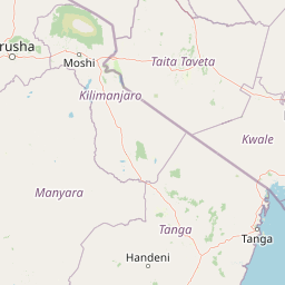
Map view of Kilimanjaro National Park

Use this park location map to pinpoint Kilimanjaro National Park in Tanzania, understand its exact geographic position, and read its mapped placement within the surrounding landscape more clearly.

Pigeon | © OpenStreetMap contributors

Location context for Kilimanjaro National Park

Kilimanjaro Region
Park atlas

Compare adjacent protected landscapes and trace regional park geography across the East African Rift Valley.

Discover Other National Parks and Protected Areas Near Kilimanjaro National Park
Continue your geographic exploration beyond Kilimanjaro National Park by browsing other national parks and protected areas in the surrounding region. Compare diverse landscapes, from volcanic peaks and alpine ecosystems to vast savannas and montane forests, enriching your understanding of East African conservation geography.
National parkKenya

Amboseli National Park: Kenya National Park Protected Landscape Atlas

Mapped geographic context and protected area boundaries.

Amboseli National Park is a protected national park in Kenya, offering a distinct geographic entity for exploration. This atlas-focused view details the park's mapped boundaries and regional landscape context. Understand its role as a national park and a significant protected area within the broader geography of Kenya for structured discovery.

Area
392 km²
Established
1974
IUCN
II
Visitors
120K annual
National parkArusha Region

Arusha National Park: A Protected Landscape in Tanzania's Arusha Region

Explore its mapped boundaries and regional geography.

Arusha National Park represents a significant protected landscape within the Arusha Region of Tanzania, offering specific geographic details for atlas-based exploration. This national park's identity is tied to its mapped natural terrain and its position within the broader regional context. Users can delve into the park's protected status and geographic features, making it a valuable entity for understanding the landscape of northern Tanzania.

Area
137 km²
Established
1960
IUCN
II
Visitors
66.8K annual
National parkTaita-Taveta County

Tsavo West National Park: Kenya's Protected National Park and Regional Geography

Explore mapped boundaries and natural landscapes in Taita-Taveta County.

Tsavo West National Park offers a focused exploration of protected landscape and regional geography within Kenya. Discover the mapped extent of this national park, understanding its role as a conservation area in Taita-Taveta County. This entry provides key geographic context and atlas-style information, highlighting the natural terrain and protected boundaries for detailed discovery.

Area
9,065 km²
Established
1948
IUCN
II
Relief
Mixed relief
National parkArusha Region

Lake Manyara National Park: Protected Landscape & Rift Valley Geography in Arusha Region

Unique habitats from groundwater forests to alkaline lake shores.

Lake Manyara National Park is a distinct protected landscape situated within the Great Rift Valley of Tanzania's Arusha Region. The park's geography is shaped by the imposing escarpment wall and the alkaline Lake Manyara, creating a mosaic of habitats including rare groundwater forests, acacia woodlands, and saline grasslands. Its unique environment supports diverse wildlife and offers a prime example of regional landscape context and protected area dynamics.

Area
648 km²
Established
1960
IUCN
II
Visitors
178.5K annual
National parkKenya

Tsavo East National Park: Kenya's Protected Natural Landscape for Geographic Exploration

Explore mapped boundaries and regional park geography.

Tsavo East National Park in Kenya offers a rich entry point for understanding protected landscapes and regional geography. As a designated national park, its mapped boundaries and natural terrain provide essential context for geographic exploration within East Africa. This page serves as a focused discovery point for the park's specific environmental attributes and its role in the broader atlas of protected areas.

Area
13,747 km²
Established
1948
IUCN
II
Relief
Lowland
National parkManyara Region

Tarangire National Park: A Detailed Look at its Mapped Boundaries and Protected Landscape

National park geography in Manyara Region, Tanzania

Tarangire National Park stands as a core protected area within Tanzania's Manyara Region, offering a deep dive into its specific geographic attributes and mapped boundaries. This page provides essential atlas context for understanding the park's landscape character and its placement within the regional geography. Focus on the park's protected status and its unique natural terrain, providing a factual basis for geographic discovery and research.

Area
2,850 km²
Established
1970
IUCN
II
Visitors
161.8K annual
National parkTanzania

Mkomazi National Park: Tanzania's Vast Protected Savanna Landscape and Wildlife Geography

Explore its mapped terrain and conservation significance within East Africa.

Mkomazi National Park is a critical protected landscape in Tanzania, spanning over 3,200 square kilometers of classic East African semi-arid savanna woodland. This national park offers a unique atlas-style view into conservation success, particularly for its black rhinoceros sanctuary and African wild dog programs. Its landscape is characterized by rolling terrain and Acacia-Commiphora vegetation, forming a vital transboundary conservation area with Kenya that supports significant wildlife migration corridors and provides a distinct geographic context within the broader regional atlas.

Area
3,234 km²
Established
2006
IUCN
II
Visitors
1.6K annual
National parkKenya

Nairobi National Park: Detailed Geographic Overview and Protected Landscape Atlas

Explore the mapped boundaries and regional context of this Kenyan national park.

Nairobi National Park represents a significant protected national park entity within Kenya. This MoriAtlas entry provides detailed insight into its geographic placement and mapped landscape characteristics. Users can delve into the park's specific location, its protected boundaries, and its contribution to the regional geography of East Africa, facilitating structured map-based exploration and understanding of this vital conservation area.

Area
117 km²
Established
1946
IUCN
II
Relief
Mixed relief

Common questions about visiting, size, designation, and location context for Kilimanjaro National Park

Kilimanjaro National Park FAQs for park facts, access, geography, and protected area context
Find quick answers about Kilimanjaro National Park, including protected-area facts, park geography, trail and visitor context, and how the park fits into its surrounding country and regional landscape.
MoriAtlas Explorer

Continue Your Protected Areas Search Across the Global Atlas

Deepen your exploration by continuing the structured search for national parks and protected areas worldwide. Utilize the comprehensive filtering capabilities to compare different conservation landscapes and refine your understanding of global park geography. Discover more about the distribution and characteristics of protected natural areas.

Global natural geography