

Mori Atlas logo
Nature reserveKirindy Forest

A vital protected landscape featuring dry deciduous forests and baobab ecosystems

Kirindy Forest Nature Reserve: Exploring the Geography of a Western Madagascar Dry Forest

Kirindy Forest stands as a critical protected landscape within western Madagascar, encompassing 125 square kilometers of dry deciduous forest. Situated in the broader Toliara Province, the reserve serves as a significant biological refuge for endemic lemurs, the fossa, and rare plant communities. Its geography is defined by seasonal water cycles that shape the distribution of its towering baobab trees and specialized succulents.

dry deciduous forestMadagascarendemic wildlifelemursbaobabsprivate nature reserve

Kirindy Forest

Nature reserve

Park overview

Structured park overview, official facts, and landscape profile for Kirindy Forest

Kirindy Forest park facts, protected area profile, and essential visitor context

Review the core facts for Kirindy Forest, including designation, size, terrain, visitor scale, habitats, and operating context in one park-focused overview.

About Kirindy Forest

Kirindy Forest occupies a privileged position within western Madagascar's conservation landscape. The reserve lies within the boundaries of the broader Kirindy Mitea National Park, where its dry deciduous forests and riparian corridors form the northern anchor of a protected area that continues south toward the Mozambique Channel. Kirindy's specific contribution to that larger park is its relatively intact dry-forest ecosystem, a habitat type that has been heavily reduced across Madagascar through conversion to agriculture, logging, and recurrent fire.

The reserve's environmental character is defined by sharp seasonal contrasts. During the long dry season, the canopy thins and leaf-shedding gives the forest a semi-open appearance, while the shorter rainy season transforms the landscape into a denser, greener environment. The forest's tree composition includes baobabs of multiple species and a mosaic of dry-adapted plants such as spiny palms, Alluaudia, and various euphorbs, making it one of the more botanically recognizable protected areas on the island.

Kirindy's broader significance lies in the convergence of ecological, scientific, and conservation interests. Its concentration of micro-endemic species, including several primates that occur nowhere else, has made it a focal point for field research on Madagascar's dry forests. At the same time, the reserve's location in Central Menabe, where deforestation pressure has been intense, positions it as a critical refugium. Combined with its accessibility from Morondava, this has elevated Kirindy's profile as a flagship site for understanding both the richness and the vulnerability of Madagascar's western dry forests.

Quick facts and research context for Kirindy Forest

Kirindy Forest is a privately managed reserve in the Menabe region of western Madagascar. It sits within the larger Kirindy Mitea National Park and is recognized as one of the largest areas of protected dry deciduous forest on the island. Its biodiversity profile is exceptional, with the majority of the species recorded within it being endemic to Madagascar and many restricted to the local region. The reserve experiences a strongly seasonal tropical climate, with a long dry season during which most trees shed their leaves, followed by a short rainy season that brings almost all of the annual precipitation.

Protection and recognition

Examine the terrestrial protection scope and recorded international recognition parameters for Kirindy Forest.

Kirindy Forest Protection Status and Documented Conservation Framework

Kirindy Forest maintains a recorded terrestrial protection scope within its documented conservation framework. Official records compile available administrative designations and management parameters for geographic analysis.

Protection details

Protection scope
Terrestrial
Park context

Deeper park guide and search-rich context for Kirindy Forest

Kirindy Forest history, landscape, wildlife, and travel context

Explore Kirindy Forest through its history, landscape character, ecosystems, wildlife, conservation priorities, cultural context, and seasonal travel timing in a structured park guide built for atlas discovery and search intent.

Why Kirindy Forest stands out

Kirindy Forest is best known for hosting an extraordinary concentration of endemic wildlife in a relatively compact dry-forest setting. It is particularly celebrated for the diversity of lemurs that inhabit it, including Madame Berthe's mouse lemur, the world's smallest primate, and several other nocturnal mouse lemurs and larger lemur species such as Verreaux's sifaka and the red-tailed sportive lemur. The reserve is also widely recognized for its striking dry-forest flora, especially the presence of three species of baobab trees within a single area, a remarkable botanical feature. Madagascar's largest chameleon, Oustalet's chameleon, also occurs here, as does the rare and endangered Malagasy giant jumping rat, for which Kirindy may be the most important surviving habitat. Together, these features give Kirindy a strong identity as both a primate-watching destination and one of the most botanically distinctive dry forests in Madagascar.
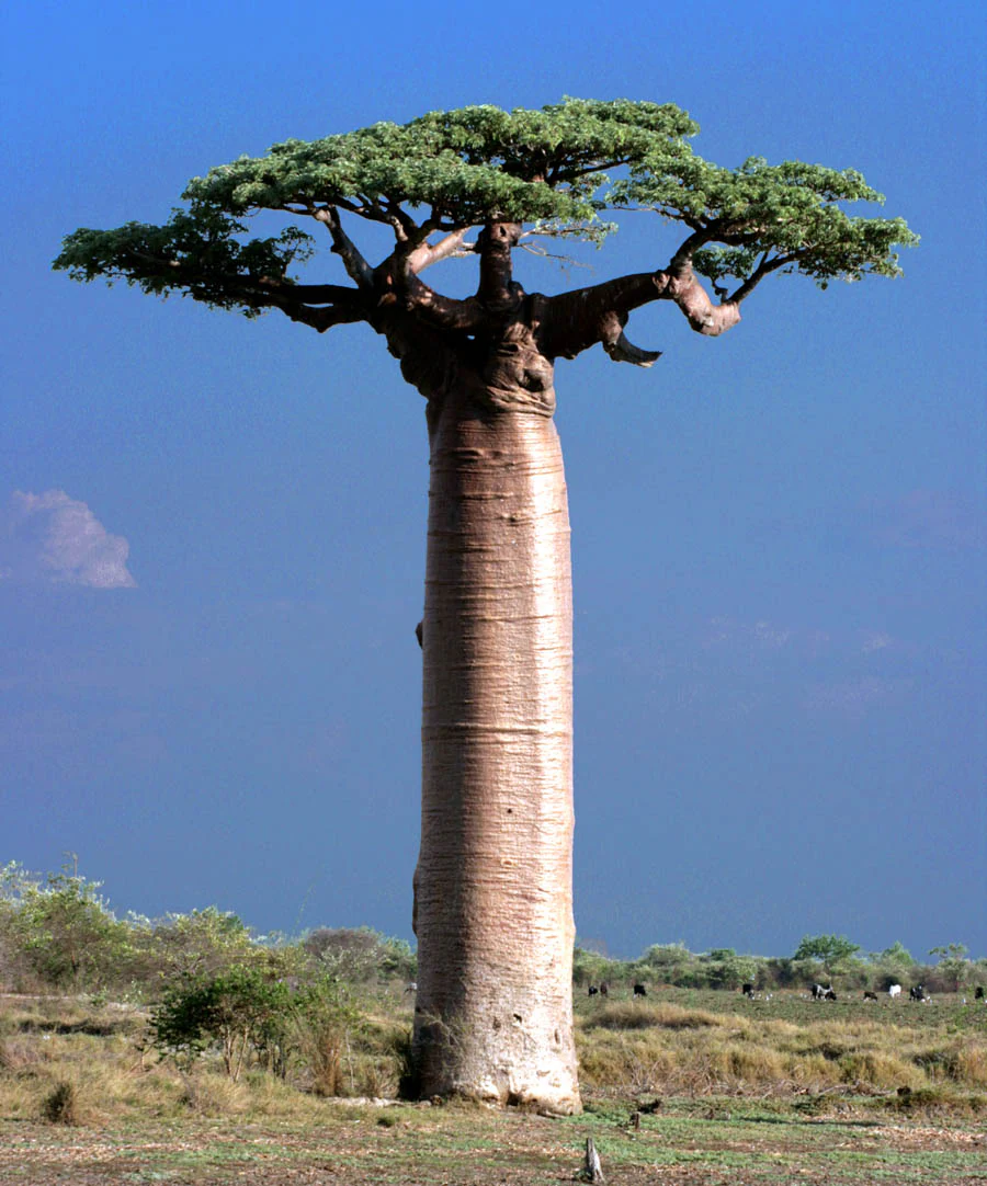
A large, thick-trunked baobab tree with a flat-topped canopy of green leaves stands alone in a grassy, arid field under a clear blue sky.
A solitary Adansonia grandidieri, or Grandidier's baobab, standing in a dry forest clearing.

Kirindy Forest history and protected-area timeline

The history of Kirindy Forest reflects both its ecological uniqueness and the deep human pressures facing western Madagascar. Before it carried the name Kirindy, the area was referred to as the Swiss people's forest, la foret des Suisses, reflecting that the land was owned by a Swiss company. The reserve's early management model was based on a sustainable timber harvesting experiment, an unusual approach for a private reserve in Madagascar and one tied to the broader reality that deforestation has long affected the Menabe region.

The Malagasy name Kirindy itself carries historical weight. According to local cultural tradition, the forest was named long ago with a word meaning something like dense forest with wild animals, a description that still fits the reserve today. The site is also known as Kirindy Nord, or northern Kirindy, to distinguish it from the larger Kirindy Mitea National Park of which it is a part.

In recent decades, Kirindy's conservation history has been shaped by mounting threats, including accelerating deforestation, large-scale land conversion for rice cultivation, and recurrent human-induced fires. Despite these pressures, the reserve has retained recognition as one of Madagascar's most important dry-forest refuges, and its role in safeguarding narrowly endemic species has only grown as surrounding habitat has deteriorated.

Kirindy Forest landscape and geographic character

The landscape of Kirindy Forest is shaped by the dry deciduous forest type that dominates western Madagascar's Menabe region. The terrain is generally flat to gently undulating, with the forest's structure strongly influenced by seasonal water availability. In drier areas, the canopy typically reaches modest heights, while along the forest's riparian zones, where moisture is more reliable, trees grow taller and form a denser vertical structure.

The scene is visually defined by its mix of towering baobab trees and a host of dry-adapted plants. Three species of baobab occur in the Kirindy area, including the iconic Grandidier's baobab, the bottle-shaped fony baobab, and Adansonia za, each contributing a distinctive silhouette during the leafless dry season. The understory and middle layers include spiny succulents and dry-forest specialists such as various Alluaudia species and euphorbs, lending the forest a characteristically open, almost otherworldly appearance during the dry months.

Climate strongly shapes the visual rhythm of the landscape. The long dry season, lasting roughly from April through November, sees most trees drop their leaves, opening up views across the forest and revealing the structural shapes of baobabs and large trunks. The brief rainy season, from roughly December to March, brings concentrated precipitation and transforms the forest into a lush, dense green environment that contrasts sharply with the parched dry-season scene.
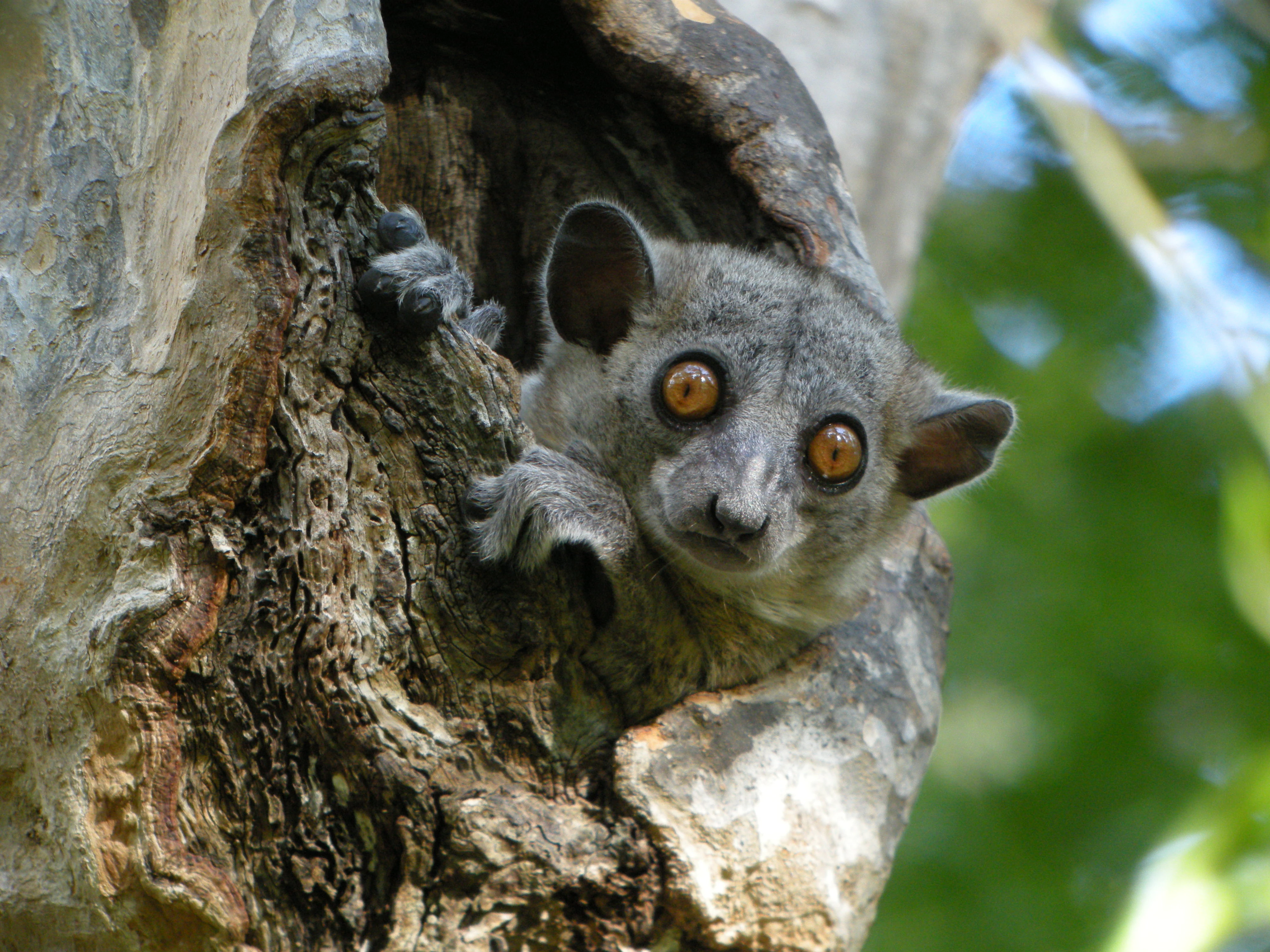
A close-up view of a small grey lemur with large orange eyes looking out from a natural hollow in a tree trunk.
A Red-tailed Sportive Lemur peering from a hollow in a tree within Kirindy Forest.

Kirindy Forest ecosystems, habitats, and plant life

Kirindy Forest represents one of the largest and most ecologically significant blocks of dry deciduous forest remaining in Madagascar. As an ecosystem, it lies within the broader Menabe dry-forest complex, a habitat type that supports an extraordinary concentration of endemic plant and animal species despite the relatively harsh seasonal conditions. The forest's structure is a mosaic of dry upland forest and wetter riparian corridors, the latter forming critical refuges for moisture-loving species during the dry season.

The reserve's ecological importance is amplified by the high degree of endemism across nearly every group of organisms it supports. Vast percentages of Madagascar's reptile and amphibian species are found nowhere else on Earth, and Kirindy reflects this broader pattern. The forest functions as a refuge for habitat specialists that depend on the dry-forest mosaic, including endemic plants adapted to seasonal drought and the cryptic animal communities that depend on those plants for survival.

Ecological interactions in Kirindy are tightly tuned to the seasonal cycle. As baobab fruits and other plant resources become available around the transition into the rainy season, they attract insects, lemurs, and other animals, creating brief periods of intense biological activity. The forest's ability to regenerate after disturbance, particularly fire, depends on its canopy structure, tree density, and species composition, all of which have been documented by researchers studying the reserve.
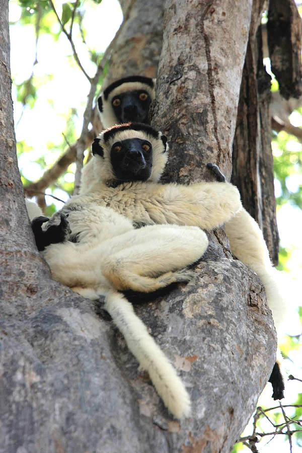
Two white and black lemurs, identified as Verreaux's sifakas, are perched in the crook of a large tree branch in a dry forest environment.
Two Verreaux's sifakas resting in the branches of a tree in Kirindy Forest.

Kirindy Forest wildlife and species highlights

The wildlife of Kirindy Forest is one of the reserve's defining features. The forest supports a remarkable diversity of mammals, with particular emphasis on primates. Multiple species of lemur occur here, ranging from the diminutive Madame Berthe's mouse lemur, the world's smallest primate, to larger and more conspicuous species such as Verreaux's sifaka and the red-fronted brown lemur. Many of Kirindy's lemurs are nocturnal or crepuscular, including the grey mouse lemur, Coquerel's giant mouse lemur, the fat-tailed dwarf lemur, the pygmy mouse lemur, and the pale fork-marked lemur.

The reserve's carnivore community is anchored by the fossa, Madagascar's largest predator and a cat-like member of the mongoose family. Fossa prey heavily on lemurs and significantly shape primate behavior across the forest. Other notable mammals include the narrow-striped mongoose and the ring-tailed vontsira, both of them endemic carnivores. Kirindy is also considered one of the most important habitats for the Malagasy giant jumping rat, an endangered species that moves in a hopping, kangaroo-like fashion and survives in only a small number of locations.

Reptile and amphibian diversity at Kirindy is equally exceptional. The forest is home to roughly fifty reptile species, including a striking array of chameleons, leaf-tailed geckos, plated lizards, and several endemic snakes such as the giant hog-nosed snake and the Madagascar ground boa. Madagascar's largest chameleon, Oustalet's chameleon, occurs here, alongside the more range-restricted Furcifer nicosiai. Amphibians include members of several frog families, among them Mantellidae, with species adapted either to year-round activity or to surviving the dry season underground. Birdlife adds another layer, with numerous species recorded in the reserve, many of them endemic to Madagascar.
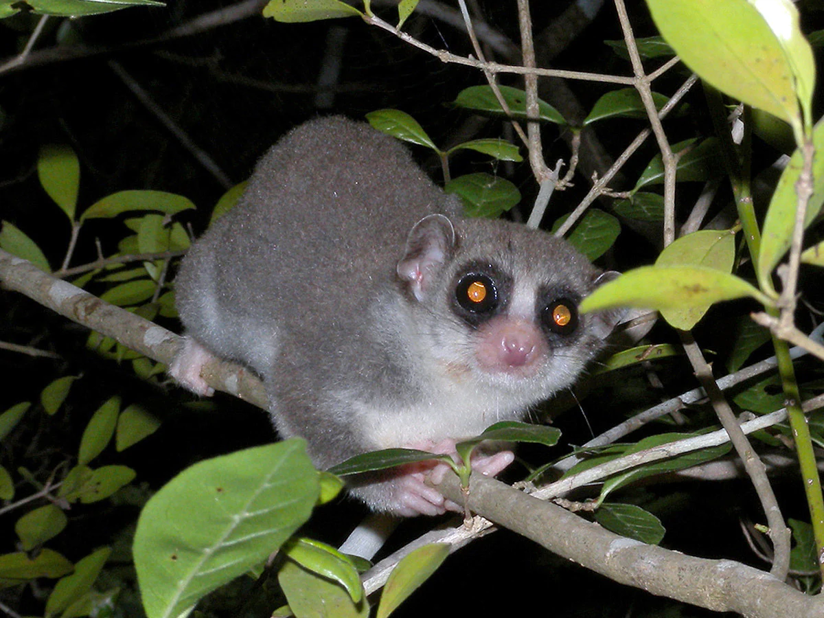
A small fat-tailed dwarf lemur with large orange eyes clinging to a thin tree branch at night, surrounded by dark foliage.
A fat-tailed dwarf lemur perched in the branches of the Kirindy Forest at night.

Kirindy Forest conservation status and protection priorities

Kirindy Forest carries substantial conservation significance as one of the largest protected dry deciduous forests in Madagascar and as a refuge for many of the island's most range-restricted species. Its ecological value is heightened by the exceptionally high levels of endemism across its fauna and flora, and by the fact that several species, including the Malagasy giant jumping rat, may rely on Kirindy as one of their last viable habitats.

The reserve sits within the larger Kirindy Mitea National Park, giving it institutional protection that has not, however, insulated it from broader regional pressures. The Menabe region has experienced one of the highest deforestation rates in Madagascar, with dry and spiny forests losing significant cover each year. Additional threats include large-scale land conversion for rice agriculture, recurrent human-induced fires linked to hunting, honey collection, and cattle grazing, and natural disturbances such as cyclones.

Conservation research at Kirindy has been substantial, with the reserve serving as a long-term study site for understanding dry-forest ecology, fire impacts, regeneration dynamics, and species vulnerability. The documented capacity of the forest to recover after fire over decadal timescales underscores the importance of preserving canopy structure and species composition, while ensuring that reforestation efforts, which are currently entirely natural, can continue to offset ongoing losses.

Kirindy Forest cultural meaning and human context

The cultural context of Kirindy Forest is closely tied to its Malagasy heritage and its more recent foreign ownership history. In Malagasy tradition, the name Kirindy itself is said to mean something like dense forest with wild animals, a phrase that captures both the original character of the forest and its enduring identity as a wildlife-rich refuge. The name thus reflects a cultural memory of the forest as a place defined by its animal life and its density of vegetation.

Before being known as Kirindy, the area was referred to as the Swiss people's forest, or la foret des Suisses, reflecting the Swiss corporate ownership of the land. This episode in the forest's history marks an early instance of foreign investment in Madagascar's natural landscape, with the early model built around experimental sustainable timber harvesting rather than full protection.

Today, Kirindy is embedded in the wider Menabe regional context, where local communities have been affected by land conversion for rice agriculture and where the forest represents both a cultural landmark and a contested economic resource. The reserve's position within Kirindy Mitea National Park reflects a more recent alignment of its private conservation role with broader national and international conservation agendas.

Top sights and standout views in Kirindy Forest

Kirindy Forest stands out as one of the most important dry-forest conservation areas in Madagascar, combining exceptional biodiversity with strong scientific and cultural significance. Its most distinctive highlights include the coexistence of three species of baobab trees within a single protected area, an unusually rich assemblage of lemurs that includes the world's smallest primate, and the presence of Madagascar's largest chameleon. The reserve also harbors the endangered Malagasy giant jumping rat in what may be one of its last reliable habitats.

Equally noteworthy is the reserve's role as a living laboratory for understanding fire ecology and dry-forest recovery, as well as its location within the larger Kirindy Mitea National Park. This combination of ecological richness, conservation significance, and research value gives Kirindy a profile that extends well beyond its modest size.

Best time to visit Kirindy Forest

The character of a visit to Kirindy Forest is shaped strongly by the seasonal cycle that defines the entire Menabe region. The long dry season, running roughly from April through November, is marked by leaf-shedding across the forest, open canopies, easier walking conditions, and warm temperatures. This period offers excellent wildlife observation, with nocturnal lemur species often easier to locate around their tree holes and the baobab-dominated landscape at its most visually iconic.

The brief rainy season, roughly from December to March, transforms the forest into a denser, greener environment where wildlife can be more difficult to spot but the landscape itself is at its most lush. Access can also become more challenging during the rainy months due to mud and wet conditions. For visitors interested in combining wildlife viewing with comfortable conditions, the dry season generally offers the clearest experience, while the rainy season rewards those drawn to the forest's greener and more atmospheric character.
Monthly climate preview

Long-term monthly averages and representative coordinate climatology data for Toliara Province

Kirindy Forest Climate Normals, Annual Temperature and Precipitation Patterns

Kirindy Forest records measured mean temperatures ranging from 21.79 degrees Celsius to 28.42 degrees Celsius alongside distinct monthly precipitation variations across the year. Reviewing the comprehensive twelve-month climatology dataset provides deeper insight into long-term temperature ranges and precipitation normals for this location.
Annual mean25 °C
22 °C28 °C
Jan27°
Feb26°
Mar26°
Apr25°
May23°
Jun22°
Jul22°
Aug23°
Sep26°
Oct27°
Nov28°
Dec28°
Warmest month
November

28.4 °C

Coolest month
July

21.8 °C

Wettest month
January

10 mm/day

Driest month
August

0.1 mm/day

Park location guide

Geography guide, regional context, and park location map for Kirindy Forest

Kirindy Forest park geography, regions, and map view in Madagascar

Understand where Kirindy Forest sits in Madagascar through a broader geographic reading of the surrounding landscape, nearby location context, and its mapped position within the national park landscape.

How Kirindy Forest fits into Madagascar

Madagascar is an island nation in the Indian Ocean, positioned off the southeastern coast of Africa. As the world's fourth-largest island and second-largest island country, it stands out for its exceptional biodiversity, over 90% of its wildlife is endemic, making it one of 17 megadiverse countries. The population is approximately 32 million, with Antananarivo as both the capital and largest city.

Wider geography shaping Kirindy Forest in Madagascar

Madagascar lies in the Indian Ocean off the southeastern coast of Africa, separated from the mainland by the Mozambique Channel. The island is situated approximately 400 km from the African continent. As the world's fourth-largest island, it also includes numerous smaller peripheral islands.

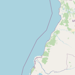
Map view of Kirindy Forest

Use this park location map to pinpoint Kirindy Forest in Madagascar, understand its exact geographic position, and read its mapped placement within the surrounding landscape more clearly.

Pigeon | © OpenStreetMap contributors

Location context for Kirindy Forest

Toliara Province

Visual reference for dry deciduous forest habitats, baobab trees, and protected terrain

Kirindy Forest Photos and Landscape Scenery in Western Madagascar

Visual documentation captures the flat terrain, towering baobab silhouettes, and dry-adapted plant communities defining western Madagascar. Photographic records reveal seasonal structural shifts across the protected dry forest and its endemic wildlife habitats.

A large, thick-trunked baobab tree with a flat-topped canopy of green leaves stands alone in a grassy, arid field under a clear blue sky.

Two red-fronted brown lemurs with brown and white fur and orange eyes sitting together on a thin tree branch.

A close-up view of a small grey lemur with large orange eyes looking out from a natural hollow in a tree trunk.

Two white and black lemurs, identified as Verreaux's sifakas, are perched in the crook of a large tree branch in a dry forest environment.

A small fat-tailed dwarf lemur with large orange eyes clinging to a thin tree branch at night, surrounded by dark foliage.

A textured brown and grey lizard with a distinctively spiny tail resting on a weathered, dark wooden log.

Park atlas

Compare western dry forests, baobab habitats, and surrounding protected areas in Madagascar.

Parks Near Kirindy Forest: Protected Areas and Regional Landscapes to Explore

Browse nearby national parks and protected areas to compare the dry deciduous forests and endemic wildlife surrounding Kirindy Forest. Extending geographic comparison across the Menabe region reveals broader patterns in regional park geography and conservation landscapes.
National parkMadagascar
Mapped park locations coincide#1 closest

Kirindy Mitea National Park: Madagascar National Park with Distinct Protected Landscape Identity

Explore the mapped geographic context of Kirindy Mitea National Park.

Kirindy Mitea National Park serves as a notable protected area, holding national park status within Madagascar's distinctive island geography. This entry focuses on understanding the park's unique protected landscape and its charted boundaries, offering essential context for atlas-driven exploration. Discover the geographic elements that define Kirindy Mitea National Park and its place within the broader conservation map of the region.

Area
1,563.5 km²
Established
1997
IUCN
IV
Relief
Mixed relief
Nature reserveMadagascar
About 81 km away#2 closest

Northeast

Réserve spéciale d'Andranomena: Protected Nature Reserve in Western Madagascar

Deciduous forest canopy, seasonal wetlands, and endemic baobab ecosystems.

Réserve spéciale d'Andranomena protects a significant block of dry dense forest within the Menabe region. The territory is known for its monumental baobab specimens, intricate seasonal hydrology, and high concentrations of Malagasy endemic species. This nature reserve provides a critical baseline for understanding the western island landscape, bridging the gap between coastal dune influence and interior deciduous terrain.

Area
64.2 km²
Established
1958
IUCN
IV
Relief
Lowland
Marine protected areaMadagascar
About 168 km away#3 closest

Southwest

Velondriake Marine Protected Area: Coastal Geography and Conservation Landscape in Madagascar

A large-scale community marine reserve in southwestern Madagascar.

Velondriake protects 64,000 hectares of marine and terrestrial environment, spanning coral reefs, extensive mangroves, and inland baobab-rich spiny forests. As a focal point for regional marine management, the area showcases the intersection of coastal ecology and community governance in the western Indian Ocean. Explore the geographic boundaries and habitat features that define this significant marine protected territory along the coast of Madagascar.

Area
640 km²
Established
2006
Relief
Lowland
Climate
Tropical
National parkIhorombe Region
About 191 km away#4 closest

Southeast

Isalo National Park: Explore Madagascar's Sandstone Canyons and Protected Landscape Geography

Discover unique geology, tapia woodlands, and regional park context.

Isalo National Park is a prominent protected area in Madagascar's Ihorombe Region, celebrated for its spectacular sandstone landscape. This national park features deep canyons, eroded rock domes, and striking runiform mountains, formed from ancient sedimentary deposits. The park preserves significant tapia woodlands and remarkable plant endemism, offering a rich context for understanding protected land distribution and Madagascar's unique geography. Its mapped terrain provides a visual atlas of natural wonders.

Area
815.4 km²
Established
1962
IUCN
II
Visitors
32.7K annual
National parkMelaky
About 196 km away#5 closest

North

Tsingy de Bemaraha National Park: A Protected Landscape within Melaky, Madagascar

Explore mapped boundaries and regional geography for atlas discovery.

Tsingy de Bemaraha National Park is a designated national park offering profound opportunities for geographic discovery. As a key protected area in the Melaky region, its mapped boundaries and natural landscape characteristics are vital for understanding Madagascar's conservation geography. This resource facilitates detailed atlas exploration, providing structured insights into the park's terrain and its position within the broader regional context, enabling a focused study of its protected land identity.

Area
723.4 km²
Established
1997
IUCN
II
Visitors
10.1K annual
Natural monumentAtsimo-Andrefana
About 214 km away#6 closest

South

Analavelona Natural Monument: An Isolated Montane Forest Refuge in Southwestern Madagascar

Mapping a sacred and biodiverse massif in the Atsimo-Andrefana region

Analavelona Natural Monument represents a striking geographic contrast, standing as an elevated montane forest massif surrounded by arid plains. This protected landscape contains a complex ecological mosaic, ranging from humid evergreen forests to rocky sclerophyllous slopes. Recognized for its sacred status and high level of narrow-range endemism, the massif serves as an essential ecological island within the broader topography of southwestern Madagascar.

Area
44.87 km²
Established
2015
Relief
Mountain
Climate
Tropical
Marine protected areaMelaky
About 229 km away#7 closest

North

Barren Isles Marine Protected Area: Geographic Overview and Island Chain Mapping

Exploration of the nine islands in the Mozambique Channel.

The Barren Isles comprise a distinct chain of nine islands and sand banks stretching across the Mozambique Channel in Madagascar. This marine protected area offers a look into a complex coastal system that balances sensitive wetland habitats with seasonal maritime migration. Gain geographic perspective on this isolated archipelago located within the Melaky region, where shifting marine environments create a unique natural landscape.

Water
Water-dominated
National parkAtsimo-Andrefana
About 230 km away#8 closest

South

Zombitse-Vohibasia National Park: Protected Landscape and Regional Geographic Context

Mapped protected areas and natural terrain discovery.

Investigate Zombitse-Vohibasia National Park, a designated national park within the Atsimo-Andrefana region. This dedicated entry provides detailed geographic information, focusing on the park's mapped terrain and its contribution to the regional protected landscape. Gain insight into the park's atlas-relevant features and its specific place within Madagascar's conservation geography.

Area
363.08 km²
Established
2002
IUCN
II
Relief
Upland

Common questions about visiting, size, designation, and location context for Kirindy Forest

Kirindy Forest FAQs for park facts, access, geography, and protected area context

Find quick answers about Kirindy Forest, including protected-area facts, park geography, trail and visitor context, and how the park fits into its surrounding country and regional landscape.
MoriAtlas Explorer

Continue Your Protected Areas Search Across the Global Atlas

Deepen your exploration by continuing the structured search for national parks and protected areas worldwide. Utilize the comprehensive filtering capabilities to compare different conservation landscapes and refine your understanding of global park geography. Discover more about the distribution and characteristics of protected natural areas.

Global natural geography