

Mori Atlas logo
National parkKismayo National Park

Mapped geographic boundaries and regional context within Lower Juba.

Kismayo National Park: Somalia's National Park and Protected Landscape Identity

Kismayo National Park stands as a significant protected landscape within Somalia, identified as a National Park. This page offers an atlas-driven exploration of its precise geographic scope and mapped boundaries, providing context within the Lower Juba region. Understand the park's identity as a protected area and its place in the broader natural landscape, facilitating detailed geographic discovery.

national parkcoastal savannawildlife conservationSomaliaJuba Valleyprotected area

Kismayo National Park

National park

Park overview

Structured park overview, official facts, and landscape profile for Kismayo National Park

Kismayo National Park park facts, protected area profile, and essential visitor context
Review the core facts for Kismayo National Park, including designation, size, terrain, visitor scale, habitats, and operating context in one park-focused overview.

About Kismayo National Park

Kismayo National Park occupies a strategic position in southern Somalia's Lower Juba region, approximately 17 kilometers inland from the Indian Ocean coastline near Kismayo. The protected area encompasses a landscape of coastal savanna and woodland that characterizes much of the Juba Valley corridor. This region historically supported diverse wildlife populations, and the park was established to preserve these ecological communities and their habitat. The park's setting places it within a broader ecosystem that includes riverine environments, open savanna, and semi-arid woodland zones. Despite challenges related to regional instability and limited infrastructure development, the reserve maintains its role as a designated protected area for wildlife conservation. The park's management has historically addressed water availability for wildlife, particularly during drought conditions when natural water sources become scarce.

Quick facts and research context for Kismayo National Park

Kismayo National Park is situated in Lower Juba, Somalia, roughly 17 kilometers west of Kismayo town, with Jamaame serving as the nearest urban center. The park is classified as an IUCN Category II protected area, designation for national parks. It features coastal savanna and woodland habitats characteristic of southern Somalia's Juba Valley ecosystem. The reserve is home to several indigenous primate species, including Vervet monkeys, along with populations of large mammals such as elephants, impala, and predators including leopards, lions, and hyenas. Local water infrastructure, including constructed ponds, has historically supported wildlife during drought periods.

Park context

Deeper park guide and search-rich context for Kismayo National Park

Kismayo National Park history, landscape, wildlife, and travel context
Explore Kismayo National Park through its history, landscape character, ecosystems, wildlife, conservation priorities, cultural context, and seasonal travel timing in a structured park guide built for atlas discovery and search intent.

Why Kismayo National Park stands out

Kismayo National Park is distinguished by its population of indigenous wildlife, particularly the Vervet monkeys that freely roam within the protected habitat. The park represents one of the few remaining protected savanna environments in southern Somalia, providing refuge for elephants, impala, leopards, lions, and hyenas. Its location along the Juba River valley gives it ecological significance as a corridor for wildlife movement in a region where natural habitats have been significantly altered. The park's value lies in its role as a protected area for species adapted to the coastal savanna environment of Lower Juba.

Kismayo National Park history and protected-area timeline

The establishment of Kismayo National Park reflects Somalia's broader efforts in the latter half of the twentieth century to create protected areas that preserve the nation's natural heritage. The park was designated to protect the wildlife populations and habitats of the Lower Juba region, an area with ecological significance due to its position along the Juba River system and its mix of coastal and inland environments. During periods of drought that affected Somalia in recent decades, conservation efforts included the construction of artificial water bodies within the park to prevent wildlife migration and maintain stable populations of elephants, impala, and other species. These management interventions demonstrated the park's ongoing conservation function even as broader regional conditions presented challenges for protected area management.

Kismayo National Park landscape and geographic character

The landscape of Kismayo National Park consists of coastal savanna terrain typical of southern Somalia's Lower Juba region. The area features open grasslands dotted with scattered trees and woodland patches, characteristic of the transition between the Indian Ocean coastal zone and the more arid interior regions. The terrain generally lies at low elevation, consistent with the coastal plain of southern Somalia. Vegetation patterns include grass-covered plains with patches of acacia and other drought-resistant tree species. The landscape provides habitat for a range of wildlife species adapted to savanna environments, with the park offering both open grazing areas and more sheltered woodland zones.

Kismayo National Park ecosystems, habitats, and plant life

The ecological character of Kismayo National Park reflects the coastal savanna ecosystem of the Juba Valley in southern Somalia. This habitat type supports a community of wildlife species adapted to seasonal rainfall patterns and relatively dry conditions for much of the year. The park's protected status provides important habitat conservation for species ranging from small primates to large mammals. Vegetation communities include grassland savanna with scattered woody plants, creating a heterogeneous landscape that supports different wildlife requirements. The Juba River system influences the broader region, though the park itself occupies higher ground above the river valley. This ecosystem represents one of the more productive habitat types in Somalia for wildlife, supporting both browsers and grazers.

Kismayo National Park wildlife and species highlights

Kismayo National Park is home to a population of indigenous wildlife species that represent the fauna of southern Somalia's coastal savanna ecosystems. The Vervet monkey is among the most notable species present, occurring in significant numbers within the protected area and contributing to the park's distinctive character. Large mammals including elephants and impala have historically maintained populations within the park, supported by both natural habitat and artificial water sources created during drought management efforts. Predators including leopards and lions are present, along with hyenas. The presence of these predator species indicates a functioning food web within the protected ecosystem. The wildlife community reflects the broader savanna fauna of the Juba Valley region.

Kismayo National Park conservation status and protection priorities

Kismayo National Park represents an important conservation asset for Somalia, providing protected status to wildlife habitat in a region where natural environments face multiple pressures. The park's designation as an IUCN Category II protected area reflects its primary function as a national park dedicated to ecosystem conservation and wildlife protection. Conservation value is particularly significant given the broader context of habitat loss and human conflict that has affected much of Somalia's natural landscape. The protected area maintains populations of species that depend on savanna habitats, including both herbivores and their predators. Ongoing conservation challenges include maintaining water availability during dry seasons and managing human-wildlife interactions in the surrounding landscape.

Kismayo National Park cultural meaning and human context

Kismayo National Park is also known by its local Somali name, Haabar Waalid, reflecting the cultural connection between the landscape and regional communities. The park is situated within the territory of the Somali people, and its management has historically involved local communities in the Lower Juba region. The area has been inhabited by pastoralist and agricultural communities whose relationship with the land and wildlife has shaped the cultural landscape. The construction of water infrastructure during drought periods represented a management approach that sought to maintain wildlife populations while acknowledging the challenges facing both people and animals in the region. This historical context informs the park's identity as both a natural protected area and a cultural landscape within Somali territory.

Top sights and standout views in Kismayo National Park

Kismayo National Park offers one of the most accessible protected wildlife experiences in southern Somalia, with its proximity to Kismayo making it a potential destination for visitors interested in observing African savanna wildlife in a protected setting. The park's indigenous Vervet monkey populations are a distinctive feature, while the presence of elephants, impala, leopards, lions, and hyenas provides opportunities for wildlife observation. The coastal savanna landscape of the Juba Valley offers a different character from Somalia's more arid northern regions, with greater vegetation density and more varied wildlife communities. The park's role in maintaining wildlife populations during drought conditions through water management demonstrates its ongoing conservation function.

Best time to visit Kismayo National Park

The optimal time to visit Kismayo National Park would align with the dry season conditions typical of southern Somalia, when wildlife concentrates around water sources and visibility improves in the less dense vegetation. The period from November through March generally offers the most favorable conditions for wildlife observation, with lower rainfall and more accessible terrain. However, visitors should be aware that Somalia's broader security situation affects travel to the region, and current conditions may limit access to the protected area. The park's accessibility from Kismayo provides a practical advantage for visitors who can travel to the area, though infrastructure within the park remains limited.
Park location guide

Geography guide, regional context, and park location map for Kismayo National Park

Kismayo National Park park geography, regions, and map view in Somalia
Understand where Kismayo National Park sits in Somalia through a broader geographic reading of the surrounding landscape, nearby location context, and its mapped position within the national park landscape.

How Kismayo National Park fits into Somalia

Somalia is a federal parliamentary republic located at the easternmost point of continental Africa. Formerly colonised by Britain and Italy, it gained independence in 1960 when British and Italian Somaliland merged. The country has endured prolonged civil conflict since 1991 but has recently stabilised under a federal government. Mogadishu serves as both the capital and largest city.

Wider geography shaping Kismayo National Park in Somalia

Somalia occupies the Horn of Africa region, stretching along the eastern coast of the continent. It borders Ethiopia to the west, Djibouti to the northwest, Kenya to the southwest, the Gulf of Aden to the north, and the Indian Ocean to the east. The terrain is predominantly arid plains and plateau, with the Juba and Shabelle rivers in the south.

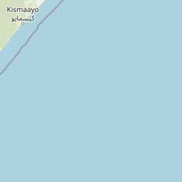
Map view of Kismayo National Park

Use this park location map to pinpoint Kismayo National Park in Somalia, understand its exact geographic position, and read its mapped placement within the surrounding landscape more clearly.

Pigeon | © OpenStreetMap contributors

Location context for Kismayo National Park

Lower Juba
Park atlas

Compare diverse savanna environments and map regional protected areas surrounding Kismayo National Park.

Discover Other National Parks and Protected Areas Near Kismayo National Park, Somalia's Coastal Region
Browse a curated selection of national parks and protected areas geographically near Kismayo National Park, extending your exploration across Somalia's coastal savanna and Juba Valley regions. Comparing these diverse landscapes offers insight into regional conservation efforts and broader wildlife habitats within East Africa.
National parkLower Juba

Lag Badana National Park National Park: Mapped Geography and Protected Landscape Context

Explore the distinct geographic identity of this protected national park.

Lag Badana National Park is a designated national park within the Lower Juba region, offering a focused look at protected landscapes and regional geography. This entry provides an atlas-oriented perspective on the park's mapped boundaries and its significance as a conservation area. Understand its place within the broader geographic context of Somalia through its defined park lands.

Area
3,340 km²
IUCN
II
Climate
Tropical
Scope
Mixed
Watercolor painting showing a landscape with mountains in the background, green hills in the midground, and water or wetland in the foreground
National parkKenya

Malindi Marine National Park: Kenya's National Park Atlas of Coastal Protected Lands

Explore mapped marine geography and protected landscape context.

Malindi Marine National Park is a protected national park situated along Kenya's coast, contributing to the nation's atlas of conservation landscapes. This entry details the park's specific geographic identity, its mapped boundaries, and its role as a protected marine environment. Engage with its regional context and understand how its protected status shapes its unique landscape for a deeper geographic appreciation.

Relief
Lowland
Climate
Tropical
Access
Access unknown
Scope
Marine
National parkTana River County

Kora National Park: A Unique Protected Landscape in Tana River County, Kenya

Explore its inselberg geography and mapped natural terrain.

Kora National Park represents a remarkable protected area characterized by its striking inselberg topography and semi-arid bushland, set against the backdrop of the Tana River. This national park in Tana River County offers a unique geographic profile, featuring massive granite formations that punctuate the expansive terrain. Discover the mapped boundaries and the distinctive landscape that make Kora National Park a significant entity for regional atlas exploration and understanding protected lands in eastern Africa.

Area
1,788 km²
Established
1989
IUCN
II
Relief
Mixed relief
Marine protected areaKenya

Watamu Marine National Park: Coastal Protected Marine Landscape in Kenya

Explore mapped boundaries and regional geography.

Watamu Marine National Park represents a crucial marine protected area situated on Kenya's coastline, contributing significantly to the country's conservation landscape. This designation underscores its role in preserving coastal and underwater geography, making it a key entity for atlas exploration of protected marine environments. Understanding its specific geographic scope and mapped protected boundaries is essential for comprehending Kenya's broader environmental atlas.

Established
1968
Relief
Lowland
Climate
Tropical
Access
Moderate access
National parkCoast Province

Arabuko Sokoke National Park: National Park Atlas and Geographic Identity in Coast Province

Mapped protected area within Kenya's coastal region.

Arabuko Sokoke National Park is identified as a protected national park situated within the historical Coast Province of Kenya. This entry offers a focused examination of its protected landscape and geographic significance, contributing to a structured atlas of protected areas. Users can explore the park's mapped boundaries and its positioning within the regional geography, providing essential context for understanding this natural landscape.

Area
6 km²
Established
1990
IUCN
II
Relief
Lowland
National parkEastern Province

Meru National Park National Park: Mapped Protected Boundaries and Eastern Province Geography

Explore regional landscape context and natural terrain.

Meru National Park represents a vital national park entity within the Eastern Province of Kenya, offering unique opportunities for structured geographic and atlas exploration. This page details its protected landscape identity, emphasizing mapped boundaries and the surrounding regional context. Users interested in conservation lands and natural terrain can find comprehensive details on Meru National Park's geographic significance and its role within the broader atlas of protected areas.

Area
870.44 km²
Established
1966
IUCN
II
Relief
Upland
National parkKenya

Tsavo East National Park: Kenya's Protected Natural Landscape for Geographic Exploration

Explore mapped boundaries and regional park geography.

Tsavo East National Park in Kenya offers a rich entry point for understanding protected landscapes and regional geography. As a designated national park, its mapped boundaries and natural terrain provide essential context for geographic exploration within East Africa. This page serves as a focused discovery point for the park's specific environmental attributes and its role in the broader atlas of protected areas.

Area
13,747 km²
Established
1948
IUCN
II
Relief
Lowland
National parkMandera County

Malka Mari National Park: Remote Frontier Protected Landscape and Dawa River Ecosystem

Explore the semi-arid bushland and riparian woodland geography.

Malka Mari National Park offers a profound wilderness experience as Kenya's most remote national park, situated along the Dawa River in Mandera County. This protected area features striking contrasts between arid bushland and verdant riparian woodlands, supporting unique plant species and wildlife adapted to the semi-arid environment. Its vast, undeveloped character makes it a significant site for frontier conservation and a unique destination for atlas-style landscape exploration.

Area
1,500 km²
Established
1989
IUCN
II
Climate
Arid

Common questions about visiting, size, designation, and location context for Kismayo National Park

Kismayo National Park FAQs for park facts, access, geography, and protected area context
Find quick answers about Kismayo National Park, including protected-area facts, park geography, trail and visitor context, and how the park fits into its surrounding country and regional landscape.
MoriAtlas Explorer

Continue Your Protected Areas Search Across the Global Atlas

Deepen your exploration by continuing the structured search for national parks and protected areas worldwide. Utilize the comprehensive filtering capabilities to compare different conservation landscapes and refine your understanding of global park geography. Discover more about the distribution and characteristics of protected natural areas.

Global natural geography
