
Mori Atlas logo
Nature reserveKleine Röder

Tracing the mapped boundaries and geographic corridor of this Elbe-Elster wetland mosaic

Kleine Röder Nature Reserve: An Atlas of Protected Wetland Landscapes in Brandenburg, Germany

(Naturschutzgebiet Kleine Röder)

Kleine Röder Nature Reserve represents a key protected landscape within the Elbe-Mulde lowland of Brandenburg, Germany. This 385 hectare expanse serves as a critical inter-state ecological corridor, bridging Saxon community sites with the middle course of the Schwarze Elster. The site features a structured mosaic of wet meadows, fens, alluvial woodlands, and oak-mixed forests, centered around the course of the Kleine Röder river. Beyond its ecological significance for wetland birds and amphibians, the reserve includes the cultural-historical site of the Kosilenzien Slavic ringwall.

wetlandlowlandnature reservefloodplainwet meadowsfens
A stylized illustration showing a valley with mountains, two waterfalls, a river, and evergreen trees.

Kleine Röder

Nature reserve

Park overview

Structured park overview, official facts, and landscape profile for Kleine Röder Nature Reserve

Kleine Röder Nature Reserve park facts, protected area profile, and essential visitor context

Review the core facts for Kleine Röder Nature Reserve, including designation, size, terrain, visitor scale, habitats, and operating context in one park-focused overview.

About Kleine Röder Nature Reserve

Kleine Röder is one of more than two dozen designated nature reserves within the Elbe-Elster district of southern Brandenburg. Administratively, the protected area lies within the town of Bad Liebenwerda and extends southwest of the village of Zeischa, following the watercourse of the Kleine Röder, a left-hand branch of the Große Röder system. With an extent of roughly 385 hectares, the reserve represents one of the more substantial lowland protected sites in the region.

The landscape protected by the reserve reflects the character of the Elbe-Mulde lowland, where geological and hydrological conditions have produced extensive marshy and forested floodplain terrain. Wet meadows, fens, pond systems, and stretches of standing and flowing water alternate with alluvial woodland, oak-mixed forest, and willow thickets. This heterogeneous structure is not incidental: it is precisely the alternation of open wetland, shrub, and woodland habitats that allows a broad range of plant communities to coexist, from tall-herb and reed vegetation through floating-leaf and submerged aquatic plant communities to floodplain and oak-mixed forest.

Ecologically, the reserve serves as a habitat management area under IUCN Category IV. The statutory protection order of 1 June 2011 emphasizes not only the conservation of individual species and habitats but also the preservation of the particular beauty and structural richness of the Niederungslandschaft (lowland) landscape. Beyond its local significance, the site is recognized as a component of a larger interregional biotope network connecting habitats across the state border between Brandenburg and Saxony.

Culturally, the area is enriched by the presence of a Slavic ringwall at Kosilenzien, situated within the boundaries of the nature reserve. This early medieval defensive earthwork adds a historical dimension to the otherwise nature-focused site and reflects how human settlement and natural landscape have long coincided in this lowland region.

Quick facts and research context for Kleine Röder Nature Reserve

Kleine Röder is a state-designated nature reserve in Brandenburg, Germany, established on 1 June 2011 under district identifier 1623 and listed in the World Database on Protected Areas. It covers approximately 385 hectares in the Elbe-Mulde lowland, within the municipal area of Bad Liebenwerda in the district of Elbe-Elster. The reserve protects a wetland complex of wet meadows, fens, ponds, flowing waters, alluvial woodland, and oak-mixed forest, and is classified as IUCN Category IV (Habitat/Species Management Area). A Slavic ringwall at Kosilenzien lies within the protected boundary, adding a cultural-historical element to the ecological reserve.

Protection and recognition

Review documented Natura 2000 listings, official designations, and conservation data for Kleine Röder.

Kleine Röder Protection Status and International Recognition Records

Examine the verified protection status, management scope, and international recognition records associated with Kleine Röder. Consult structured data regarding Natura 2000 designations and official database listings for this protected area.
Park context

Deeper park guide and search-rich context for Kleine Röder Nature Reserve

Kleine Röder Nature Reserve history, landscape, wildlife, and travel context

Explore Kleine Röder Nature Reserve through its history, landscape character, ecosystems, wildlife, conservation priorities, cultural context, and seasonal travel timing in a structured park guide built for atlas discovery and search intent.

Why Kleine Röder Nature Reserve stands out

The reserve is best known for protecting a diverse lowland wetland mosaic in the Elbe-Mulde floodplain. Its combination of wet meadows, fens, alluvial woodland, oak-mixed forest, and ponds creates the structural variety that supports rare plant communities and a wide range of protected wetland fauna. Kleine Röder also stands out as an important link in a transregional biotope network, connecting Saxon sites of community importance along the Röder floodplain with the middle course of the Schwarze Elster in Brandenburg. The inclusion of a Slavic ringwall at Kosilenzien gives the protected area a rare blend of natural and cultural heritage value.
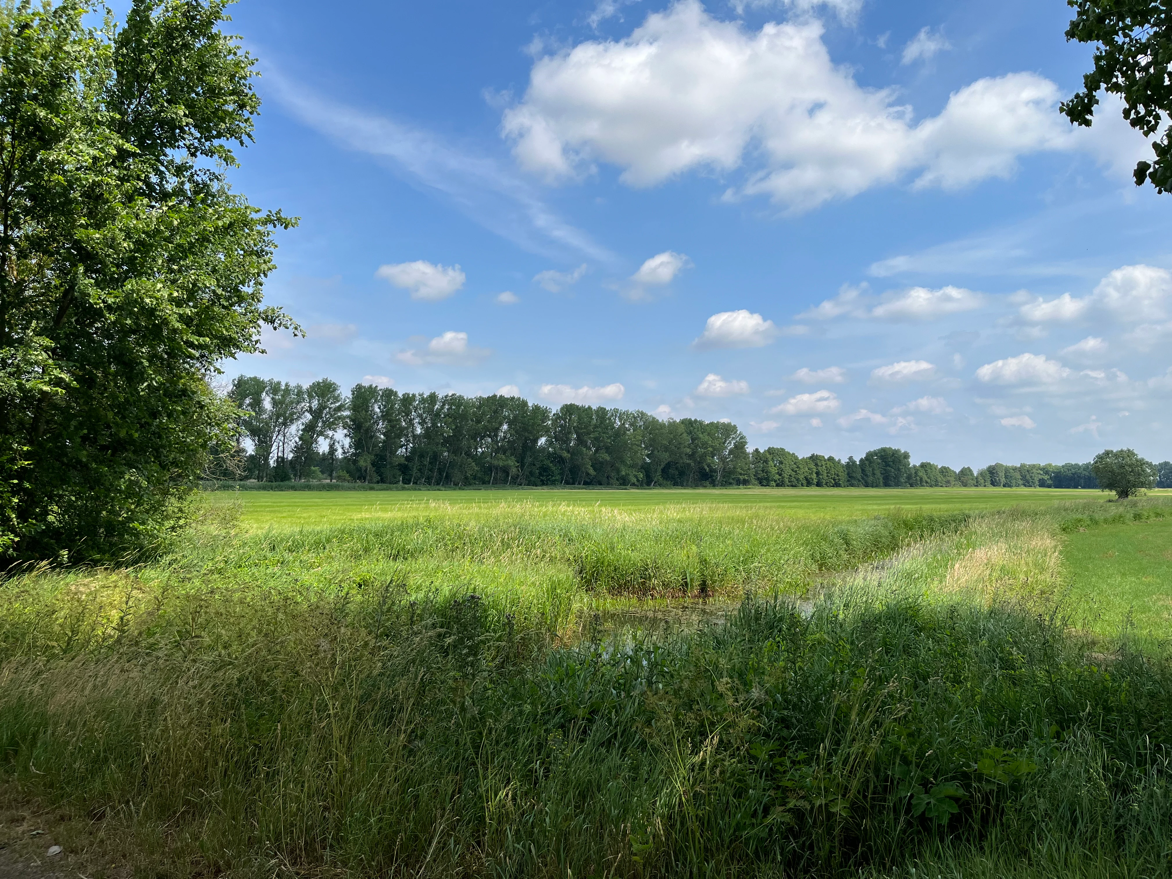
A wide, grassy meadow and wetland area under a blue sky with scattered clouds, bordered by a line of trees in the background.
A view of the wetland meadow and fen landscape within the Kleine Röder nature reserve.

Kleine Röder Nature Reserve history and protected-area timeline

The formal establishment of Kleine Röder as a nature reserve occurred on 1 June 2011, when a statutory order ("Verordnung") placed the area under legal protection. The reserve was registered with the official identifier 1623 and was subsequently included in the World Database on Protected Areas under the ID 555546323. Its designation reflects a broader trend in late 20th- and early 21st-century conservation policy in Brandenburg, where multiple lowland landscapes of the Elbe-Mulde region were identified for targeted habitat protection as their ecological value became better understood through biotope mapping and ecological assessment.

The inclusion of the Slavic ringwall at Kosilenzien within the protected boundary suggests that the historical cultural landscape has been recognized as part of the overall value of the area. Although the reserve's primary purpose is the protection of wetland ecosystems, the integration of the archaeological site within the same designation demonstrates an approach that treats the cultural and natural heritage of the lowland landscape as interconnected rather than separate.

Kleine Röder Nature Reserve landscape and geographic character

Kleine Röder lies in the Elbe-Mulde Tiefland, a lowland region of northeastern Germany shaped by glacial and fluvial processes. The terrain is flat to gently undulating, dominated by water-related landforms: wet meadows along the course of the Kleine Röder itself, fens formed in poorly drained depressions, and pond systems that capture surface water. The reserve's elevation is low, and the landscape is defined less by relief than by the interplay of water, grassland, and woodland.

The water network is a central feature of the reserve. The Kleine Röder, a left-side branch of the larger Große Röder, runs through the protected area, accompanied by both flowing and standing water bodies. Around these wet elements, the reserve maintains sections of tall herb vegetation, reed belts, and floating-leaf and submerged plant communities, transitioning outwardly to willow thickets and alluvial forests in the wetter zones, and to oak-mixed forest in slightly higher or drier transitional positions. This mosaic creates the visual and ecological signature of the site: a flat, green, water-dominated lowland dotted with ponds, reed beds, groves, and meadow openings.

The reserve's setting is also shaped by its geographic position near the southern border of Brandenburg. State roads L 64 and L 593 cross or border the area, and the state border with Saxony runs along parts of its southern and southeastern edge, situating the reserve at the interface between two federal states with related but distinct conservation landscapes.

Kleine Röder Nature Reserve ecosystems, habitats, and plant life

From an ecological perspective, the reserve's defining feature is the diversity of wetland and forest habitat types concentrated within a relatively compact area. The protected habitats include wet meadows, fens, reed communities, bankside vegetation, floating-leaf and submerged aquatic flora, tall-herb communities, alluvial woodland, and mixed oak forest. Together, these habitat types represent a near-complete inventory of characteristic lowland floodplain ecosystems in the Elbe-Mulde region.

Particularly notable is the occurrence of plant species that depend on undisturbed aquatic and semi-aquatic conditions. The water feather (Wasserfeder), yellow flag (Wasserschwertlilie), and frog's-bit (Froschkraut) are highlighted in the conservation order as species of special concern. Their presence, along with the broader spectrum of protected plant communities listed in the site's statutory protection order, indicates that the reserve maintains the hydrological and water-quality conditions needed for sensitive aquatic flora.

The reserve's habitats also support an unusually rich fauna for an inland lowland protected area, including both resident and migratory species, and a strong representation of wetland-dependent amphibians, fish, and mammals.

Kleine Röder Nature Reserve wildlife and species highlights

Kleine Röder supports a substantial fauna of protected and ecologically important species, many of which are associated with wetland and reed habitats. Among strictly protected birds, the area is notable for ferruginous duck (Moorente), great bittern (Große Rohrdommel), bearded reedling (Bartmeise), corncrake (Wachtelkönig), northern lapwing (Kiebitz), common snipe (Bekassine), black stork (Schwarzstorch), osprey (Fischadler), marsh harrier (Rohrweihe), and corn bunting (Grauammer). Additional birdlife includes yellow wagtail (Schafstelze), great reed warbler (Drosselrohrsänger), Savi's warbler (Rohrschwirl), and kingfisher (Eisvogel), reflecting a layered songbird and reedbed community typical of intact lowland wetlands.

The reserve also supports a noteworthy amphibian fauna, including natterjack toad (Wechselkröte), European tree frog (Laubfrosch), garlic toad (Knoblauchkröte), and moor frog (Moorfrosch). The presence of great crested newt (Kammmolch) further underlines the site's value for herpetofauna. Among mammals, Eurasian beaver (Biber) and Eurasian otter (Fischotter) are recorded, both of which depend on healthy wetland and watercourse systems.

Fish species of conservation interest are also present, including the weatherfish (Schlammpeitzger) and the bitterling. The combination of these taxa demonstrates that the reserve functions not only as a bird sanctuary but as a functioning aquatic-terrestrial mosaic supporting multiple animal classes across different habitat layers.

Kleine Röder Nature Reserve conservation status and protection priorities

Conservation value at Kleine Röder rests on its role as a habitat and species management area under IUCN Category IV. The statutory protection order specifically identifies the preservation of characteristic plant communities in tall-herb, wet grassland, reed, bank-side, floating-leaf, submerged, floodplain, and oak-mixed forest habitats as core objectives. This explicit habitat-level scope distinguishes the reserve from sites that focus primarily on single-species protection.

A particularly important dimension of the reserve's conservation value is its position within the over-regional biotope network of the Elbe-Mulde lowland. The protection order explicitly identifies the site as a vital link between the Saxon site of community importance "Röderaue und Teiche unterhalb Großenhain" and the Brandenburg "Mittellauf der Schwarzen Elster" site, meaning that the reserve is not seen in isolation but as a connective element in a larger ecological corridor spanning two federal states.

The reserve also contributes to the network of protected areas within Elbe-Elster district, one of the most biodiversity-rich districts in Brandenburg. Its combination of habitat diversity, landscape-level connectivity, and statutory protection gives Kleine Röder meaningful conservation significance at the regional and inter-state level.

Kleine Röder Nature Reserve cultural meaning and human context

The reserve includes within its boundaries a Slavic ringwall (Slawischer Burgwall) at Kosilenzien, a village that is part of Bad Liebenwerda. This earthwork is an archaeological relic of the early medieval Slavic settlement of the region and represents one of the cultural-historical features that have been integrated into the protected area's designation.

The presence of the ringwall reflects the long pre-modern history of human settlement in the Elbe-Mulde lowland, where natural wetland conditions both constrained and shaped historical land use. By including this archaeological element within the protected boundary, the reserve acknowledges that the cultural and natural landscape of the region have been continuously intertwined.

Top sights and standout views in Kleine Röder Nature Reserve

Kleine Röder's standout features include its wetland habitat diversity, its functional role as a regional and inter-state ecological corridor, and the inclusion of the Kosilenzien Slavic ringwall as a cultural-historical element within the protected area. The reserve also distinguishes itself through the presence of strictly protected wetland bird species such as great bittern, ferruginous duck, and black stork, alongside intact amphibian populations and the ecological presence of beaver and otter.

As one of the larger lowland nature reserves in Elbe-Elster district, Kleine Röder provides a coherent example of how structured habitat management, statutory protection, and cultural landscape preservation can be combined within a single lowland site.

Best time to visit Kleine Röder Nature Reserve

As a lowland wetland reserve in the Elbe-Mulde region, Kleine Röder holds seasonal character throughout the year but is most vivid in late spring and early summer, when wetland vegetation reaches full growth, reedbeds are active with breeding birds, and amphibian and insect life is at its peak. Spring is also the period when migratory species such as osprey and black stork are most likely to be observed, and when wet meadows display their characteristic flowering.

Autumn and winter transform the reserve into a quieter but still ecologically rich landscape, with reduced vegetation cover enabling better visibility of open water and pond systems, and the possibility of observing waterfowl in their wintering or passage periods. Visitors interested in specific bird species will find different target species across the seasons, as reedbed breeders are active in spring and summer while waterfowl and marshland birds may be more easily approached in autumn and winter.

Monthly climate preview

Track long-term average temperature ranges and precipitation patterns across Brandenburg

Kleine Röder Climate Normals and Representative Monthly Temperature Rhythms

Representative coordinate records for Kleine Röder outline measured baseline temperature variations and monthly precipitation rates from historical NASA datasets spanning three decades. Accessing the full climate profile reveals complete twelve-month normals and detailed numerical breakdowns for deeper environmental analysis.
Annual mean9 °C
-1 °C20 °C
Jan-1°
Feb
Mar
Apr
May14°
Jun18°
Jul20°
Aug20°
Sep15°
Oct
Nov
Dec
Warmest month
July

20 °C

Coolest month
January

-0.7 °C

Wettest month
July

2.6 mm/day

Driest month
April

1.1 mm/day

Park location guide

Geography guide, regional context, and park location map for Kleine Röder Nature Reserve

Kleine Röder Nature Reserve park geography, regions, and map view in Germany

Understand where Kleine Röder Nature Reserve sits in Germany through a broader geographic reading of the surrounding landscape, nearby location context, and its mapped position within the national park landscape.

How Kleine Röder Nature Reserve fits into Germany

Germany is a federal republic in Western and Central Europe with a population of over 83 million across sixteen constituent states. It is Europe's largest economy by nominal GDP and a major global exporter and importer. The capital is Berlin, and the country borders Denmark, Poland, Czech Republic, Austria, Switzerland, France, Luxembourg, Belgium, and the Netherlands.

Wider geography shaping Kleine Röder Nature Reserve in Germany

Germany is located in Western and Central Europe, spanning 357,022 km². It borders Denmark to the north, Poland and the Czech Republic to the east, Austria and Switzerland to the south, and France, Luxembourg, Belgium, and the Netherlands to the west. The country has coastlines on the Baltic Sea and North Sea to the north, with the Alps located in the southern region.

Map view of Kleine Röder Nature Reserve

Use this park location map to pinpoint Kleine Röder Nature Reserve in Germany, understand its exact geographic position, and read its mapped placement within the surrounding landscape more clearly.

Pigeon | © OpenStreetMap contributors

Location context for Kleine Röder Nature Reserve

Brandenburg

Explore protected area views, lowland habitats, and terrain characteristics

Kleine Röder Photos: Visualizing the Wetland Landscapes and Scenery

Visual documentation captures the diverse wetland mosaic, floodplain vegetation, and water networks defining the nature reserve. Examining these protected area views reveals the flat terrain and ecological character supporting rare lowland habitats.

A wide, grassy meadow and wetland area under a blue sky with scattered clouds, bordered by a line of trees in the background.

Park atlas

Explore surrounding wetland reserves and regional conservation areas in the Elbe-Mulde lowland

Parks Near Kleine Röder and Connected Protected Landscapes

Compare Kleine Röder with adjacent protected areas across the Elbe-Elster district and neighboring lowland terrain. Analyzing connected wetland networks and regional river corridors reveals broader patterns in habitat distribution and conservation management.
A soft watercolor painting depicting a pale, hazy landscape with green grassy fields, light green trees, and distant faint mountains under a pastel sky.
Protected areaSaxony
1.4 km away#1 closest

South

Gohrischheide und Elbniederterrasse Zeithain: Geography and Protected Area Overview

Analyzing the inland dunes and dry heath landscape of the Elbe river terrace

Discover the unique geography of Gohrischheide und Elbniederterrasse Zeithain in Saxony, a protected area known for its expansive inland dunes and dry heath habitats. This region represents a rare combination of post-glacial sand landscapes and semi-open forest mosaics that reflect long-term ecological evolution and distinct regional environmental conditions.

Area
28.47 km²
Established
2011
Relief
Lowland
Climate
Temperate
A minimalist watercolor painting showing a horizontal landscape with patches of green forest and hints of marshy or open terrain against a white background.
Protected landscapeBrandenburg
About 11 km away#2 closest

Northeast

Naturpark Niederlausitzer Heidelandschaft: A Protected Landscape in Brandenburg

Mapping the glacial remnants and industrial heritage of a German lowland nature park

Naturpark Niederlausitzer Heidelandschaft offers an insightful look into the transformation of Brandenburg lowlands, where sessile oak forests, wet meadows, and post mining residual waters create a singular ecological mosaic. This destination captures the contrast between remnants of the last ice age and the deliberate rewilding of former opencast pits, providing a deep view into regional landscape evolution.

Area
484.3 km²
Established
1996
Relief
Lowland
Climate
Temperate
Nature reserveBrandenburg
20 km away#3 closest

East

Welkteich Nature Reserve: Brandenburg Industrial Legacy and Protected Habitat Mapping

Mapping a unique mosaic of post-mining terrain and historic pond systems

Located in the district of Oberspreewald-Lausitz, Welkteich represents a distinct example of how industrial-era mining scars and artificial ridges can evolve into protected nature reserves. The site serves as a vital ecological corridor, featuring a dense interspersion of aquatic basins, forest patches, and dry ground that provides a sanctuary for diverse species within the broader Brandenburg landscape.

Area
1.13 km²
Established
1981
IUCN
IV
Relief
Lowland
A soft, light-toned watercolor painting of a low, rolling landscape with green hills, sparse vegetation, and a suggestion of wetland or pond in the foreground.
Nature reserveSachsen
About 21 km away#4 closest

South

Seußlitzer und Gauernitzer Gründe: Protected Nature Reserve Map and Landscape Overview

Regional geography and habitat boundaries in the Sachsen Elbe valley.

Spanning steep slopes and narrow brook valleys on both sides of the Elbe, Seußlitzer und Gauernitzer Gründe is a defining nature reserve in Sachsen. This protected area supports a diverse mix of dry herbaceous vegetation and mature deciduous forest, serving as a critical component of the local ecological network within the broader Upper Elbe landscape.

Area
3.57 km²
Established
2013
IUCN
IV
Relief
Upland
Nature reserveBrandenburg
About 21 km away#5 closest

North

Alte Elster und Rieke: Protected Floodplain and River Geography in Brandenburg

Nature reserve featuring old river arms and wetland mosaics.

The Alte Elster und Rieke nature reserve represents one of the few surviving near-natural floodplain remnants along the Schwarze Elster river. This area supports a rich network of ponds, reed beds, and wet meadows that serve as a crucial refuge for wetland plants and wildlife within the otherwise heavily regulated Elbe-Elster lowland landscape.

Area
1.756 km²
Established
1981
IUCN
IV
Relief
Lowland
Nature reserveSachsen
About 25 km away#6 closest

South

Winzerwiese und Gosebruch: Protected Nature Reserve and Valley Geography in Sachsen

Mapping protected wet meadows and floodplain woodlands

Winzerwiese und Gosebruch is a distinctive nature reserve in Sachsen, Germany, centered on a small valley along the Gosebach stream. This protected area creates a dense mosaic of wet meadow, marshy woodland, and dry deciduous forest, offering a significant look at the region's diverse botanical landscape and river-valley geography.

Area
0.116 km²
Established
1967
IUCN
IV
Nature reserveBrandenburg
26 km away#7 closest

Northeast

Lehmannsteich Nature Reserve: Geographic Atlas of Brandenburg Protected Lowlands

Atlantic wet heath and bog-hollow conservation landscapes.

Discover the complex landscape of Lehmannsteich, a 140-hectare nature reserve in Brandenburg. This protected area showcases a distinctive transition from wet heath and peat-filled sloughs to surrounding pine woodland, illustrating the rare inland habitat types found within the Elbe-Elster region.

Area
1.405 km²
Established
1981
IUCN
IV
A soft watercolor painting of a green, marshy landscape with a winding waterway and rolling hills in the background.
Nature reserveSaxony
About 27 km away#8 closest

West

Großer Teich Torgau: A Protected Saxon Reservoir and Historic Wetland Map

Exploring the medieval pond culture and nature reserve boundaries in Saxony

Located in northern Saxony, Großer Teich Torgau is a rare surviving medieval fish pond that functions as a nature reserve and flood management reservoir. This protected landscape contains shallow water zones, historic earthen dam structures, and surrounding marshlands that illustrate centuries of continuous human and natural interaction within the regional geography.

Area
1.75 km²
Established
1484
Relief
Lowland
Scope
Terrestrial

Common questions about visiting, size, designation, and location context for Kleine Röder Nature Reserve

Kleine Röder Nature Reserve FAQs for park facts, access, geography, and protected area context

Find quick answers about Kleine Röder Nature Reserve, including protected-area facts, park geography, trail and visitor context, and how the park fits into its surrounding country and regional landscape.
MoriAtlas Explorer

Continue Your Protected Areas Search Across the Global Atlas

Deepen your exploration by continuing the structured search for national parks and protected areas worldwide. Utilize the comprehensive filtering capabilities to compare different conservation landscapes and refine your understanding of global park geography. Discover more about the distribution and characteristics of protected natural areas.

Global natural geography