
Mori Atlas logo
Nature reserveKlobichsee

Mapping the protected boundaries and aquatic ecosystems of this eastern German nature reserve

Klobichsee Nature Reserve: A Protected Glacial Lake Landscape in Brandenburg, Germany

(Naturschutzgebiet Klobichsee)

Klobichsee Nature Reserve stands as a significant protected area in the Märkisch-Oderland district of Brandenburg, Germany. Encompassing the interconnected Großer Klobichsee and Kleiner Klobichsee, this reserve protects a vital glacial lake system and its surrounding forest habitats. The mapped geography highlights a landscape defined by transition zones between open water and woodlands, serving as a key element of the regional conservation network in eastern Brandenburg.

nature reservelake landscapeglacial lakesBrandenburgwetland habitatsmixed forest
A stylized vector illustration showing a waterfall cascading between high cliffs into a calm lake, framed by pine trees and tall grasses in the foreground.

Klobichsee

Nature reserve

Park overview

Structured park overview, official facts, and landscape profile for Klobichsee Nature Reserve

Klobichsee Nature Reserve park facts, protected area profile, and essential visitor context

Review the core facts for Klobichsee Nature Reserve, including designation, size, terrain, visitor scale, habitats, and operating context in one park-focused overview.

About Klobichsee Nature Reserve

Klobichsee Nature Reserve (Naturschutzgebiet Klobichsee) is a protected landscape area in the eastern German state of Brandenburg, located in the Landkreis Märkisch-Oderland. Its name refers directly to the lake system it encompasses: the Großer Klobichsee and the smaller Kleiner Klobichsee, two bodies of water that form the ecological and visual centerpiece of the reserve.

The reserve lies southeast of the town center of Buckow, a town closely associated with the Märkische Schweiz natural park region, and west of Münchehofe, a village belonging to the municipality of Müncheberg. The federal highway B 168 runs along the western side of the reserve, providing a geographic reference point for its position within the broader Brandenburg landscape. This area is characterized by a distinctive pattern of glacial lakes, mixed forests, and lowland terrain typical of the northeastern German countryside.

Designated as a formal nature reserve under German protection law on October 1, 1990, the area is recognized under the official identifier 1127. The reserve's inclusion in the IUCN Category IV classification reflects its role as a habitat and species management area, meaning the protection framework emphasizes the conservation of particular habitats and species rather than broader wilderness preservation. This management orientation is consistent with the reserve's setting around a lake complex within a heavily used agricultural and forested region of Brandenburg, where managing shoreline ecosystems and associated woodland and wetland habitats is a priority.

The reserve sits within a wider network of protected areas in Landkreis Märkisch-Oderland, which includes numerous other Naturschutzgebiete such as the Stobbertal, Gartzsee, and Herrensee, Lange-Damm-Wiesen und Barnim-Hänge. Together, these areas preserve the area's characteristic mosaic of lakes, rivers, forests, and open land that define the natural heritage of eastern Brandenburg.

Quick facts and research context for Klobichsee Nature Reserve

Klobichsee is a nature reserve in Landkreis Märkisch-Oderland, Brandenburg, Germany, established as a protected area on October 1, 1990. It carries the official nature reserve identifier 1127 and is recorded in the World Database on Protected Areas under WDPA-ID 164146. The reserve has a total extent of approximately 5.59 square kilometers and takes in the Großer Klobichsee and the Kleiner Klobichsee. The federal highway B 168 runs along the western boundary, and the reserve lies between Buckow to the northwest and Münchehofe to the east.

Protection and recognition

Terrestrial conservation framework and Natura 2000 records for Klobichsee

Klobichsee Protection Status and Documented International Recognition

Examine the documented protection status and official Natura 2000 recognition records associated with Klobichsee. Structured protection details provide clear reference data regarding territorial conservation frameworks.

International recognition

Protection details

Protection scope
Terrestrial
Transboundary protection
No
WDPA ID
164146
Park context

Deeper park guide and search-rich context for Klobichsee Nature Reserve

Klobichsee Nature Reserve history, landscape, wildlife, and travel context

Explore Klobichsee Nature Reserve through its history, landscape character, ecosystems, wildlife, conservation priorities, cultural context, and seasonal travel timing in a structured park guide built for atlas discovery and search intent.

Why Klobichsee Nature Reserve stands out

The reserve is best known for its pair of connected glacial lakes, the Großer Klobichsee and the Kleiner Klobichsee, which together form the central hydrological feature of the protected area. The surrounding forests, shorelines, and mires associated with these lakes define the protected landscape and form the basis for the site's habitat and species management designation under IUCN Category IV.
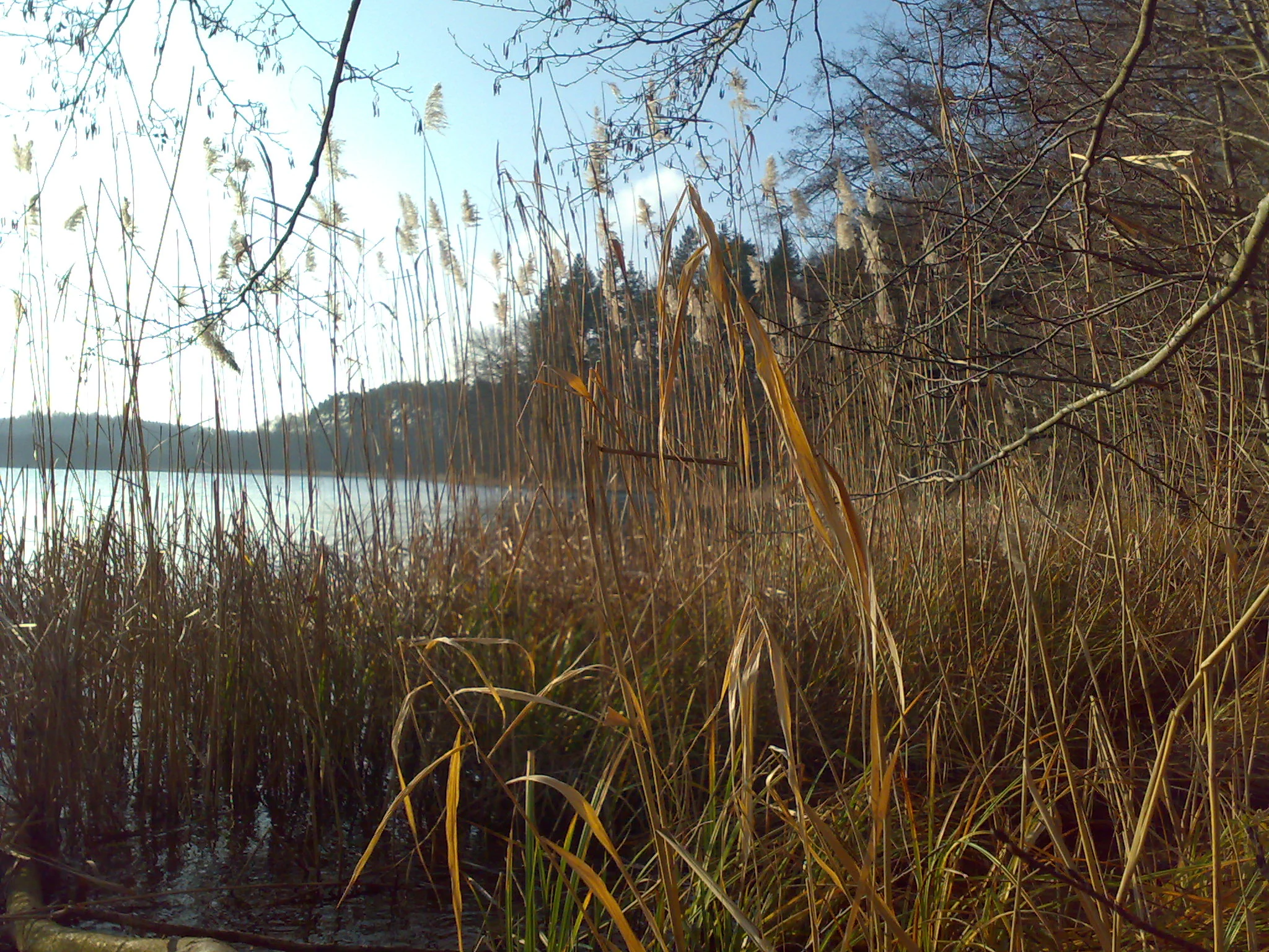
A view of the shoreline of a lake, filled with tall dry reeds and grasses in the foreground, with trees and a calm water surface visible in the background under a bright sky.
Reeds along the shoreline of Großer Klobichsee in the Klobichsee Nature Reserve.

Klobichsee Nature Reserve history and protected-area timeline

The Klobichsee area received formal nature reserve (Naturschutzgebiet) status on October 1, 1990, through a state ordinance issued under Brandenburg's nature conservation framework. The designation occurred during the early period following German reunification, when many natural areas in the former East Germany were being formally incorporated into the unified German system of protected landscapes.

The reserve was assigned the official identifier 1127, a code used within Brandenburg's catalog of designated nature reserves, and was later registered internationally in the World Database on Protected Areas under WDPA-ID 164146. Its protection focuses on the conservation of the two lakes and their surrounding habitats. The reserve is also referenced within the broader list of FFH (Fauna-Flora-Habitat) areas in Brandenburg, indicating its alignment with the European Union's Natura 2000 ecological network framework.

Klobichsee Nature Reserve landscape and geographic character

The landscape of Klobichsee Nature Reserve is defined by its central lake system, consisting of the larger Großer Klobichsee and the adjacent Kleiner Klobichsee. These lakes, of glacial origin like many others in the Brandenburg lowlands, give the protected area its defining character and provide the hydrological foundation for the surrounding ecosystems.

Beyond the water surface, the reserve encompasses the lakeshore zones, surrounding forests, and transition areas between open water and woodland. The terrain is consistent with the gently undulating lowland topography of eastern Brandenburg, shaped by glacial processes during the Pleistocene. The federal highway B 168 traces the western edge of the reserve, marking a clear boundary between the protected landscape and the surrounding transport corridor. East of the lakes, the landscape continues toward Münchehofe and the wider Märkische Schweiz region, which is known for its distinctive combination of lakes, hills, and forest.

Klobichsee Nature Reserve ecosystems, habitats, and plant life

The ecological character of the protected area centers on the lake and shoreline habitats of the two Klobichsee lakes and the surrounding forest and wetland communities that depend on them. As a designated nature reserve under IUCN Category IV, the area is specifically managed for habitat and species conservation, meaning the protection framework targets the ecological relationships tied to the lakeshore and adjacent terrestrial systems.

The mixed forests, mires, and transitional wetland zones typical of Brandenburg's lake landscapes form a significant part of the reserve's ecological mosaic. These habitats support a range of species associated with open water, reedbeds, wet woodland, and dry upland forest. The reserve's integration into the broader list of FFH (Fauna-Flora-Habitat) areas in Brandenburg suggests that the site also contributes to the protection of habitats and species of European conservation concern.

Klobichsee Nature Reserve wildlife and species highlights

The Klobichsee area's combination of open water shoreline habitat, reedbeds, damp woodland, and adjacent forest makes it relevant for waterbirds, wetland-associated fauna, and the broader forest wildlife typical of Brandenburg. The reserve's IUCN Category IV management orientation points to habitat and species as primary conservation targets, which in practice means monitoring and protecting the species tied to the lake and shoreline environments.

Like other lake reserves in Landkreis Märkisch-Oderland, the wetlands surrounding the Klobichsee lakes can provide conditions for amphibians, dragonflies, and waterbirds, while the mixed forests support typical central European woodland fauna. Because detailed species inventories are not provided in the source material, specific species highlights are limited to the general ecological themes of lake, wetland, and forest fauna.

Klobichsee Nature Reserve conservation status and protection priorities

Klobichsee Nature Reserve is classified as an IUCN Category IV protected area, meaning it is managed primarily for the conservation of specific habitats and species rather than as a strict wilderness reserve. This management category reflects a practical approach to protecting the lake complex and its associated habitats within a working landscape that includes agriculture, forestry, and road infrastructure along the B 168.

The reserve is registered internationally under WDPA-ID 164146 and is referenced within Brandenburg's list of FFH (Fauna-Flora-Habitat) sites, indicating alignment with the European Natura 2000 network. Its position within Landkreis Märkisch-Oderland, a district with a particularly high density of designated nature reserves, reinforces the regional importance of the site for maintaining ecological connectivity across Brandenburg's lake and forest landscapes.

Top sights and standout views in Klobichsee Nature Reserve

The defining feature of Klobichsee Nature Reserve is the twin-lake system of Großer Klobichsee and Kleiner Klobichsee, set within roughly 5.59 square kilometers of protected Brandenburg countryside. Established on October 1, 1990 and registered internationally in the World Database on Protected Areas, the reserve contributes both to Brandenburg's national conservation system and to the European Natura 2000 framework through its listing among the state's FFH areas.

The reserve's location between Buckow and Münchehofe places it within a culturally significant region of eastern Brandenburg, where glacial lakes, forests, and small rural communities together form a long-standing landscape identity. The Märkische Schweiz area to the northwest adds further regional context, linking Klobichsee to one of Brandenburg's better-known natural park landscapes.

Monthly climate preview

Long term temperature and precipitation records across representative Brandenburg coordinates

Klobichsee Climate Normals and Measured Annual Temperature Patterns

Representative coordinate records show measured annual temperature and precipitation ranges spanning sub-zero winter minimums to warm summer maximums. Examining monthly climate normals provides complete baseline data for Klobichsee weather by month and regional temperature trends.
Annual mean9 °C
-1 °C20 °C
Jan-1°
Feb
Mar
Apr
May14°
Jun18°
Jul20°
Aug20°
Sep15°
Oct
Nov
Dec
Warmest month
July

20.3 °C

Coolest month
January

-1.1 °C

Wettest month
July

2.5 mm/day

Driest month
April

1.1 mm/day

Park location guide

Geography guide, regional context, and park location map for Klobichsee Nature Reserve

Klobichsee Nature Reserve park geography, regions, and map view in Germany

Understand where Klobichsee Nature Reserve sits in Germany through a broader geographic reading of the surrounding landscape, nearby location context, and its mapped position within the national park landscape.

How Klobichsee Nature Reserve fits into Germany

Germany is a federal republic in Western and Central Europe with a population of over 83 million across sixteen constituent states. It is Europe's largest economy by nominal GDP and a major global exporter and importer. The capital is Berlin, and the country borders Denmark, Poland, Czech Republic, Austria, Switzerland, France, Luxembourg, Belgium, and the Netherlands.

Wider geography shaping Klobichsee Nature Reserve in Germany

Germany is located in Western and Central Europe, spanning 357,022 km². It borders Denmark to the north, Poland and the Czech Republic to the east, Austria and Switzerland to the south, and France, Luxembourg, Belgium, and the Netherlands to the west. The country has coastlines on the Baltic Sea and North Sea to the north, with the Alps located in the southern region.

Map view of Klobichsee Nature Reserve

Use this park location map to pinpoint Klobichsee Nature Reserve in Germany, understand its exact geographic position, and read its mapped placement within the surrounding landscape more clearly.

Pigeon | © OpenStreetMap contributors

Location context for Klobichsee Nature Reserve

Brandenburg

Explore protected habitats, twin glacial lakes, and forest scenery across the reserve.

Klobichsee Photos and Landscapes: Visual Guide to Brandenburg Glacial Lakes

Visual documentation captures the twin glacial lake system, surrounding forests, and wetland habitats that define the protected terrain of Klobichsee. Examining detailed field photography reveals the characteristic lowland topography and ecological structure of eastern Brandenburg conservation areas.

A view of the shoreline of a lake, filled with tall dry reeds and grasses in the foreground, with trees and a calm water surface visible in the background under a bright sky.

Park atlas

Compare nearby glacial lakes and protected landscapes across eastern Brandenburg.

Parks Near Klobichsee and Other Protected Areas in the Surrounding Region

Visitors exploring Klobichsee can browse adjacent nature reserves and wetland habitats located throughout the surrounding Brandenburg lowlands. Reviewing neighboring protected areas provides broader regional context on glacial lake ecosystems and connected conservation zones.
Nature reserveBrandenburg
Park boundaries overlap#1 closest

Northeast

Stobbertal Nature Reserve: Geography, Mapped Boundaries, and Protected Landscape Context

A detailed geographic study of the Stöbber river valley in Brandenburg, Germany

Stobbertal represents a compact yet ecologically dense protected area in Brandenburg. This study provides access to information regarding its diverse forest and wetland habitats, ranging from ancient oak-hornbeam woodlands to rare floodplain remnants. Gain insight into the regional importance of the river corridor, its hydrologic features, and the protected species that inhabit this distinct northeastern German landscape.

Area
8.84 km²
Established
1990
IUCN
IV
A soft watercolor painting of a pastoral landscape featuring green rolling hills, distant trees, and a foreground with grassy vegetation and pinkish marsh-like reflections.
Protected landscapeBrandenburg
About 2 km away#2 closest

Northwest

Naturpark Märkische Schweiz: A Protected Landscape Discovery in Brandenburg

Glacial terrain, kettle lakes, and river basin geography.

Situated near Berlin, this protected landscape features a textbook glacial relief shaped by retreating ice sheets. The area encompasses the Schermützelsee, deep kettle ponds known as Sölle, and the narrow valleys of the Stobber river. Learn about the park's layered conservation framework, which combines European habitat protection with rich fieldstone architecture and cultural history.

Area
205 km²
Established
1990
Relief
Upland
Climate
Temperate
Watercolor painting of a tranquil, flat wetland landscape with pale green, pink, and yellow hues representing water, vegetation, and a soft sky.
Nature reserveBrandenburg
About 8.4 km away#3 closest

Northeast

Europäisches Vogelschutzgebiet Altfriedländer Teich- und Seengebiet: Protected Area Geography

Nature reserve wetland network in eastern Brandenburg

Discover the geographic structure of this extensive pond and lake complex in Märkisch-Oderland. This protected area features shallow open water, sprawling reedbeds, and remnants of lowland peat that support dense populations of migratory waterfowl and rare breeding waterbirds within a working cultural landscape.

Area
7 km²
Relief
Lowland
Climate
Temperate
Scope
Terrestrial
A horizontal watercolor painting showing a soft-focus landscape of light green trees, yellow fields, and pale blue rolling hills in the background.
Nature reserveBrandenburg
About 17 km away#4 closest

West

Lange Dammwiesen und Unteres Annatal: Glacial Ridges and Nature Reserve Geography

A mapped protected area in the state of Brandenburg, Germany

Lange Dammwiesen und Unteres Annatal represents a compact but ecologically rich nature reserve featuring signature osar ridges and varied meadow habitats. This site provides valuable insight into the glacial landscape of the North German Plain, illustrating the effectiveness of conservation grazing in maintaining diverse ecosystems within the Brandenburg region.

Area
0.013 km²
Established
1990
IUCN
IV
Relief
Lowland
A horizontal watercolor illustration showing soft, pastel-colored rolling hills and a calm lake or pond in the foreground, surrounded by grassy banks.
Nature reserveBrandenburg
About 19 km away#5 closest

South

Beerenbusch Nature Reserve: Geographic Profile and Protected Woodland Landscapes of Brandenburg

Mapping forest boundaries in the German lowlands

Located in the Oder-Spree district, Beerenbusch protects rare oak-hornbeam and alder swamp forest ecosystems. This profile details the reserve landscape, cultural landmarks like the Königskiefer, and its importance as a surviving woodland refuge within the Brandenburg forest belt.

Area
0.7 km²
Established
1967
IUCN
IV
Relief
Lowland
Protected landscapePoland
25 km away#6 closest

Northeast

Park Krajobrazowy Ujście Warty: Protected Landscape and River Valley Atlas

Mapping wetland ecosystems and floodplain geography in western Poland

Park Krajobrazowy Ujście Warty preserves a significant lowland river valley landscape characterized by vast open pastures, marshes, and rare riparian oak forests. Located primarily within the Lubuskie region, this protected area offers a clear view into the floodplain processes of the Warta river basin, providing a distinct geographic context for wetland conservation and waterbird habitat mapping in Poland.

Area
194.96 km²
Established
1996
Relief
Lowland
Climate
Temperate
Protected landscapeWest Pomeranian Voivodeship
25 km away#7 closest

North

Cedynia Landscape Park: Mapped Protected Landscapes and Regional Geography in Poland

Protected mosaic of sandy forests and river valleys

Spanning 308 square kilometers, Cedynia Landscape Park protects a complex transition zone in Poland. The area features the expansive Puszcza Piaskowa pine forests, the hilly moraine relief of the Cedynia Carpathians, and the biodiverse wetlands of the lower Oder River. This protected landscape represents an essential study in lowland ecological gradients and postglacial terrain development within the West Pomeranian Voivodeship.

Area
308.5 km²
Established
1993
Relief
Upland
Climate
Temperate
Nature reserveBrandenburg
28 km away#8 closest

Southwest

Swatzke- und Skabyberge Nature Reserve and Protected Inland Dune Geography in Brandenburg

Mapping the sand heaths and forest ecosystems of northeastern Germany

Swatzke- und Skabyberge is a designated nature reserve in Brandenburg that preserves a rare inland dune complex. Originally shaped by long term military usage, this protected land now functions as a vital habitat for dry acid grasslands, lichen-rich pine forests, and wetland woodland fringes. It provides a unique study in how sand, fire, and moisture processes maintain biodiversity within the lowland German landscape.

Area
5.2 km²
Established
1999
IUCN
IV

Common questions about visiting, size, designation, and location context for Klobichsee Nature Reserve

Klobichsee Nature Reserve FAQs for park facts, access, geography, and protected area context

Find quick answers about Klobichsee Nature Reserve, including protected-area facts, park geography, trail and visitor context, and how the park fits into its surrounding country and regional landscape.
MoriAtlas Explorer

Continue Your Protected Areas Search Across the Global Atlas

Deepen your exploration by continuing the structured search for national parks and protected areas worldwide. Utilize the comprehensive filtering capabilities to compare different conservation landscapes and refine your understanding of global park geography. Discover more about the distribution and characteristics of protected natural areas.

Global natural geography