
Mori Atlas logo
Nature reserveKragenhof bei Fuldatal

Mapping the meander dynamics and riparian habitats of this significant northern Hesse nature reserve

Kragenhof bei Fuldatal: A Protected Floodplain Mosaic Within the Hesse Regional River Landscape

(Naturschutzgebiet Kragenhof bei Fuldatal)

Kragenhof bei Fuldatal is a protected nature reserve in Hesse, Germany, defined by its position on a peninsula carved by a sharp loop of the Fulda River. The landscape consists of a compact mosaic including shallow water zones, small wooded river islands, and traditional grasslands. This atlas entry provides a detailed look at the geography of this floodplain refuge, documenting how the river's path creates a unique environment for local waterbirds and aquatic ecosystems.

nature reservefloodplainFulda Riverriver meanderriparian woodlandwaterbirds
A flat-style digital illustration showing a calm river flowing through a rolling landscape with coniferous trees, hills, and a soft sunset sky.

Kragenhof bei Fuldatal

Nature reserve

Park overview

Structured park overview, official facts, and landscape profile for Kragenhof bei Fuldatal

Kragenhof bei Fuldatal park facts, protected area profile, and essential visitor context

Review the core facts for Kragenhof bei Fuldatal, including designation, size, terrain, visitor scale, habitats, and operating context in one park-focused overview.

About Kragenhof bei Fuldatal

Kragenhof bei Fuldatal is a compact nature reserve that captures one of the more intimate landscape features of the northern Hessian countryside: a peninsula formed by a pronounced meander of the Fulda River, just northeast of Kassel city. Although the reserve covers only about 7.7 hectares, its setting gives it a striking ecological diversity in a small area, bringing together the quiet dynamics of a lowland river and the semi-natural land uses along its banks.

The reserve protects shallow water zones on the slip-off slope of the Fulda meander, several small river islands, and adjoining sections of the Kragenhof peninsula. On the islands and in a narrow fringe along the riverbank, the characteristic vegetation is Auengehölze, or floodplain woodland, shaped by the regular influence of the river. Inland from the water, the reserve also includes agriculturally used grassland, a reminder that the North Hessian floodplain landscape has long been shaped by both natural river processes and traditional farming.

The site's official protection history dates back to 13 October 1981. To the southeast, the reserve borders parts of the landscape protection area ("Landschaftsschutzgebiet") known as "Stadt Kassel," placing Kragenhof bei Fuldatal within a broader mosaic of protected open spaces surrounding the city. Within this mosaic, the reserve stands out for its emphasis on aquatic and riparian habitats and for its specific importance for waterbirds, which rely on the area as a breeding, staging, and wintering site.

Quick facts and research context for Kragenhof bei Fuldatal

Kragenhof bei Fuldatal is a nature reserve (Naturschutzgebiet) of about 7.7 hectares in the city of Kassel, Hesse. It lies northeast of Kassel on the Kragenhof peninsula, formed by a loop of the Fulda River. The designation date is 13 October 1981, and the official area number is 1633103. The reserve includes shallow Fulda water zones, small islands, riparian woodland (Auengehölze), and grassland areas, and borders the landscape protection area "Stadt Kassel" to the southeast.

Protection and recognition

Examine documented protection records and official international designations.

Kragenhof bei Fuldatal Protection Status and International Recognition

Kragenhof bei Fuldatal holds documented protection records within international conservation databases. Review verified designation history and management scope without assumed legal outcomes.

Protection details

WDPA ID
164220
Park context

Deeper park guide and search-rich context for Kragenhof bei Fuldatal

Kragenhof bei Fuldatal history, landscape, wildlife, and travel context

Explore Kragenhof bei Fuldatal through its history, landscape character, ecosystems, wildlife, conservation priorities, cultural context, and seasonal travel timing in a structured park guide built for atlas discovery and search intent.

Why Kragenhof bei Fuldatal stands out

Kragenhof bei Fuldatal is best known for its compact mosaic of Fulda River floodplain habitats, combining shallow water zones along a river meander, small wooded islands, and traditional grassland. The reserve is specifically valued as a refuge for waterbirds, which use the area for breeding, resting during migration, and wintering. Its meander-driven peninsula setting and integration of aquatic, riparian, and open grassland habitats make it a characteristic example of small-scale floodplain protection in northern Hesse.
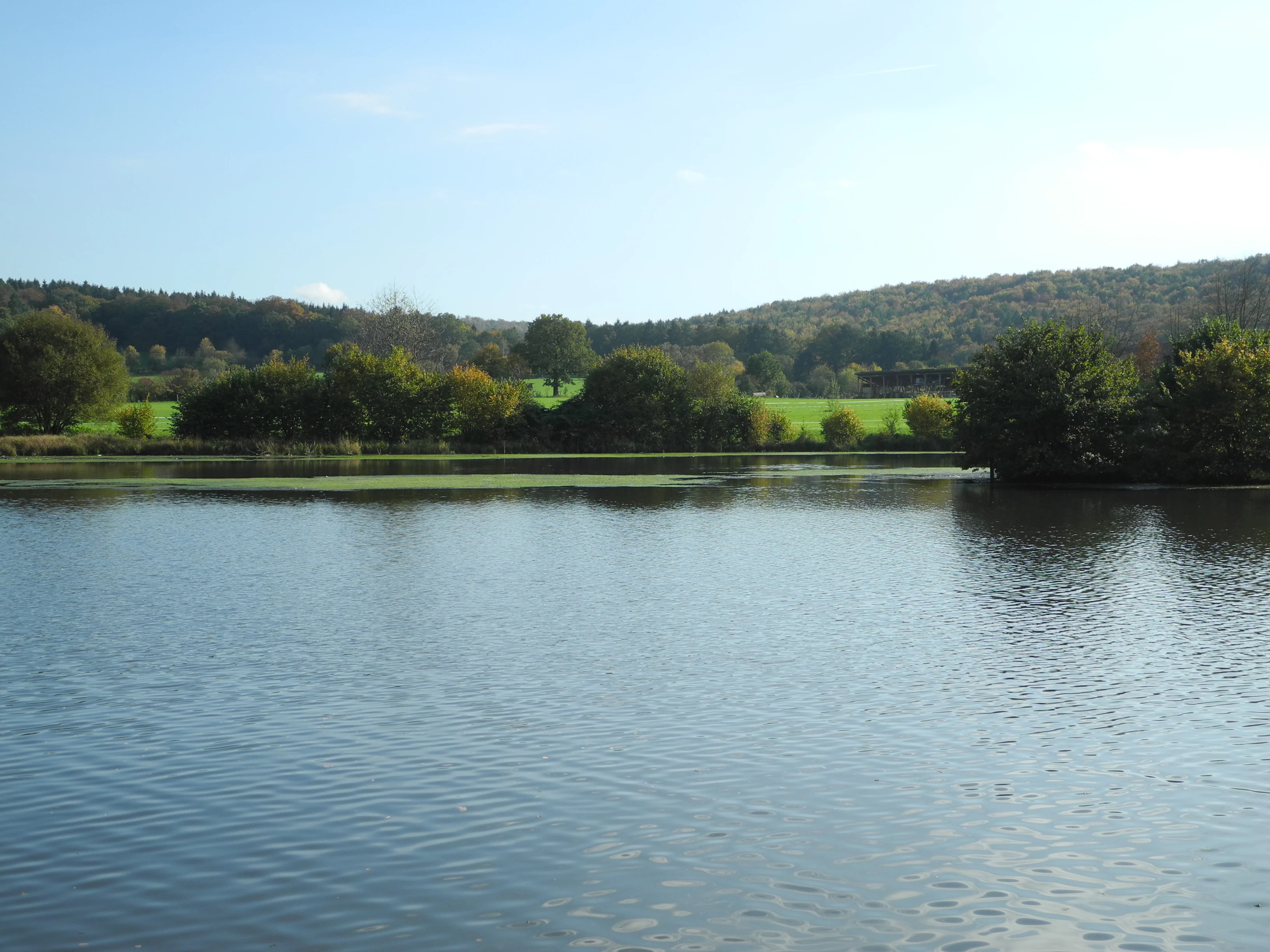
A wide, calm river in the foreground, with lush green trees and rolling forested hills in the background under a clear sky.
The Fulda River flows past the wooded banks of the Kragenhof bei Fuldatal nature reserve.

Kragenhof bei Fuldatal history and protected-area timeline

Kragenhof bei Fuldatal has been formally protected as a nature reserve (Naturschutzgebiet) since 13 October 1981. It was designated under the official area number 1633103 and has remained in that protected status since, being listed among the nature reserves of the city of Kassel. The reserve's location on the Kragenhof peninsula, shaped by a Fulda River meander, has given it long-term ecological value, and its formal designation was aimed at conserving both the riverine habitats and the traditional grassland patches that characterize the floodplain landscape north of Kassel.

Kragenhof bei Fuldatal landscape and geographic character

The defining feature of Kragenhof bei Fuldatal is its peninsula setting within a loop of the Fulda River. A pronounced river meander cuts around the Kragenhof landmass, creating a broad curve where the river's slip-off slope (Gleithang) produces the shallow water zones that the reserve protects. Several small islands sit within this meander, adding to the visual and ecological complexity of the site.

Along the edge of the river and on the islands, the landscape is shaped by water: constantly shifting currents, sediment deposition, and the influence of fluctuating water levels. Inland, the peninsula transitions into flatter ground where agricultural grassland has been maintained, giving the reserve a balance of dynamic aquatic terrain and more stable, traditionally managed open land. The contrast between flowing water, wooded islands, and open grassland makes the reserve a classic, if compact, example of a floodplain mosaic in northern Hesse.

Kragenhof bei Fuldatal ecosystems, habitats, and plant life

The ecological identity of Kragenhof bei Fuldatal rests on the interplay between the Fulda River and the surrounding peninsula. Shallow water zones along the river's slip-off slope support aquatic and semi-aquatic communities adapted to the gentle, depositional side of the meander. Small islands within the river add a layer of transitional habitat, where water and land meet in changing configurations.

On these islands and along a narrow stretch of the riverbank, the dominant vegetation is Auengehölze, floodplain woodland composed of tree and shrub species typical of riparian environments in central Germany. This woodland benefits from periodic influence of the river and contributes to the structural diversity of the site. Inland from the water, the reserve also encompasses grassland areas that are still used for agriculture, providing additional habitat variety and reinforcing the semi-natural character of the floodplain landscape.

Kragenhof bei Fuldatal wildlife and species highlights

Kragenhof bei Fuldatal is primarily known for its importance to waterbirds (Wasservögel). The combination of shallow river water, sheltered islands, and adjacent open habitats makes the area attractive to a range of aquatic and semi-aquatic bird species throughout the year. The reserve is explicitly noted for serving these birds as a breeding area, a staging site during migration periods, and a wintering refuge.

The mix of open water, wooded islands, and surrounding grassland supports a broader community of floodplain-associated fauna that benefits from the protected status of the site. While the reserve is small, its consistent protection since 1981 has helped maintain its function as a reliable refuge for waterbirds against a backdrop of urban and agricultural pressures around Kassel.

Kragenhof bei Fuldatal conservation status and protection priorities

The core conservation purpose of Kragenhof bei Fuldatal is to safeguard a representative slice of the Fulda floodplain, including shallow water zones, islands, floodplain woodland, and adjoining grassland. Designated as a Naturschutzgebiet in 1981, the reserve forms one element of the network of protected natural areas in and around Kassel, and it borders the landscape protection area "Stadt Kassel" to the southeast. This positioning allows it to function not only as a standalone refuge but also as part of a larger framework of protected open spaces around the city.

By protecting the habitats of a Fulda meander in combination with traditional land use, the reserve helps preserve both ecological function and the characteristic appearance of the northern Hessian floodplain landscape.

Kragenhof bei Fuldatal cultural meaning and human context

Kragenhof bei Fuldatal reflects the long-standing relationship between the Fulda River and human land use in the Kassel region. The peninsula's name, tied to the historical Kragenhof farmstead, points to agricultural presence along the river for generations. The continued use of parts of the reserve as agricultural grassland shows that the area's cultural and ecological histories remain intertwined, with traditional land management supporting part of the habitat mosaic alongside the more naturally dynamic river features.

Top sights and standout views in Kragenhof bei Fuldatal

The reserve's strongest points of distinction lie in its compact yet varied floodplain habitat mosaic, which combines shallow Fulda water zones, wooded islands, riparian woodland, and traditional grassland within a single small site. Its position on a meander-shaped peninsula gives the area a particularly expressive geography, and its longstanding designation as a protected waterbird refuge is central to its identity. Together, these qualities make Kragenhof bei Fuldatal a characteristic example of small-scale floodplain conservation in the area around Kassel.

Best time to visit Kragenhof bei Fuldatal

Because Kragenhof bei Fuldatal is valued primarily as a waterbird refuge, the seasons when waterbirds are most visible tend to be especially rewarding. Migratory periods bring staging birds to the shallow waters of the Fulda meander, while winter can offer views of cold-season visitors on the river and adjacent open areas. Spring and early summer highlight the breeding season behaviors of waterbirds on the islands and banks, when the riparian woodland is also in active growth. Visitors interested in observing the interplay between the river, islands, and grassland habitats will find the reserve engaging across much of the year, though weather and water conditions can strongly shape the atmosphere of the site.

Monthly climate preview

Long-term monthly temperature and precipitation data for Hesse

Kragenhof bei Fuldatal Climate Normals and Annual Temperature Rhythm

Representative coordinates record sustained temperature variation alongside measured monthly precipitation levels across the location. Examining the full twelve-month climate profile reveals comprehensive multi-year baseline statistics for further study.
Annual mean8 °C
-1 °C18 °C
Jan-1°
Feb
Mar
Apr
May12°
Jun16°
Jul18°
Aug18°
Sep14°
Oct
Nov
Dec
Warmest month
July

18 °C

Coolest month
January

-0.6 °C

Wettest month
July

2.5 mm/day

Driest month
April

1.5 mm/day

Park location guide

Geography guide, regional context, and park location map for Kragenhof bei Fuldatal

Kragenhof bei Fuldatal park geography, regions, and map view in Germany

Understand where Kragenhof bei Fuldatal sits in Germany through a broader geographic reading of the surrounding landscape, nearby location context, and its mapped position within the national park landscape.

How Kragenhof bei Fuldatal fits into Germany

Germany is a federal republic in Western and Central Europe with a population of over 83 million across sixteen constituent states. It is Europe's largest economy by nominal GDP and a major global exporter and importer. The capital is Berlin, and the country borders Denmark, Poland, Czech Republic, Austria, Switzerland, France, Luxembourg, Belgium, and the Netherlands.

Wider geography shaping Kragenhof bei Fuldatal in Germany

Germany is located in Western and Central Europe, spanning 357,022 km². It borders Denmark to the north, Poland and the Czech Republic to the east, Austria and Switzerland to the south, and France, Luxembourg, Belgium, and the Netherlands to the west. The country has coastlines on the Baltic Sea and North Sea to the north, with the Alps located in the southern region.

Map view of Kragenhof bei Fuldatal

Use this park location map to pinpoint Kragenhof bei Fuldatal in Germany, understand its exact geographic position, and read its mapped placement within the surrounding landscape more clearly.

Pigeon | © OpenStreetMap contributors

Location context for Kragenhof bei Fuldatal

Hesse

Visualizing the floodplain habitats, river meanders, and protected terrain of northern Hesse.

Kragenhof bei Fuldatal Photos and Landscape Scenery

Examine detailed photographs of Kragenhof bei Fuldatal to understand the complex mosaic of Fulda River shallow water zones, wooded islands, and riparian habitats. Visual records offer clear insight into the protected peninsula environment, terrain features, and wetland characteristics shaping the local nature reserve.

A wide, calm river in the foreground, with lush green trees and rolling forested hills in the background under a clear sky.

Park atlas

Compare surrounding regional geography and connected floodplain reserves

Other Protected Areas and Parks Near Kragenhof bei Fuldatal

Browse nearby protected areas located close to Kragenhof bei Fuldatal to examine regional river valleys and wetland habitats. Connecting individual site data with broader landscape maps reveals adjacent conservation zones throughout northern Hesse.
A horizontal watercolor illustration depicting a river flowing through a lush green floodplain with trees and distant hills under a soft, light-colored sky.
Nature reserveHessen
About 4.2 km away#1 closest

Southeast

Fuldaschleuse Wolfsanger Nature Reserve: Geography and Protected Riverine Terrain

A restored floodplain ecosystem in the Hessen region.

Fuldaschleuse Wolfsanger stands as a masterfully restored nature reserve along the River Fulda. This compact 14-hectare site features a man-made island, shallow-water zones, and softwater floodplain forests that support over 120 bird species. Its layout provides a rare example of integrated conservation within a modern urban-edge environment, demonstrating the success of deliberate floodplain engineering for biodiversity.

Area
0.14 km²
Established
1985
IUCN
IV
Watercolor painting of a calm wetland landscape with soft green trees along the water edge under a light, misty sky.
Nature reserveHessen
About 7.9 km away#2 closest

Northwest

Rothenberg bei Burguffeln Protected Wetland Landscape and Nature Reserve in Hessen

A specialized pond and meadow mosaic in the Hessian lowlands

Rothenberg bei Burguffeln preserves a vital wetland complex near Immenhausen, structured across three distinct sections, including the Rothenküler Teich and Tonkaule. The area represents a significant example of culturally shaped lowland geography, blending historic aquaculture with contemporary habitat management. Its protected status reflects a commitment to maintaining intricate riparian corridors and meadow ecosystems within the wider Hessian countryside.

Area
0.278 km²
Established
1983
Watercolor painting of a soft landscape featuring green trees and rolling hills in muted tones against a white background.
Nature reserveGermany
About 8 km away#3 closest

Northeast

Bruchwald am Gahrenberg Nature Reserve: A Protected Wetland Atlas of the Reinhardswald

Mapped terrain, bog woodland, and hydrological headwaters in Hessen

Located in the Reinhardswald forest massif, Bruchwald am Gahrenberg protects critical marsh and bog woodland habitats. The area serves as a primary source for regional streams, offering a dense, spring-fed landscape that stands out within the broader northern German wilderness.

Area
0.41 km²
Established
1992
Relief
Upland
Climate
Temperate
A soft watercolor illustration of a winding stream flowing through a green meadow with rolling hills in the background and a small cluster of pine trees in the foreground.
Nature reserveHessen
About 8.2 km away#4 closest

Northwest

Jungfernbach und Brandteich bei Calden: Protected Forest and Stream Valley Geography

Regional nature reserve landscape located in northern Hessen

Examine the mapped boundaries and natural terrain of Jungfernbach und Brandteich bei Calden. This nature reserve offers a detailed look at lowland stream corridors, pond ecosystems, and riparian forest patches nestled within the rolling landscape of northern Hessen, reflecting the region's diverse protected land character.

Area
0.343 km²
Established
1985
A soft watercolor illustration showing a band of green trees reflecting in calm water, with a light hilly background.
Nature reserveHessen
About 8.5 km away#5 closest

North

Bennhäuser Teich und Rothbalzer Teich bei Immenhausen: Protected Nature Reserve and Landscape Atlas

Mapped woodland and wetland habitats in Hessen, Germany.

This nature reserve centers on historic impoundment ponds and complex valley hydrology. Its landscape features rare dragonfly habitats and successional carr woodlands that define the ecological identity of this protected area within the northern Hessen countryside.

Area
0.315 km²
Established
1998
A horizontal watercolor painting depicting a soft, atmospheric landscape with rolling green hills, a winding river or water feature, and distant pale mountains under a hazy, pastel sky.
Protected landscapeLower Saxony
About 8.7 km away#6 closest

East

Naturpark Münden Protected Landscape: Geography and Regional Mapping in Lower Saxony

Forested ridges and river valleys in southern Germany

Naturpark Münden offers a detailed look at the central German low mountain range. Discover the mapping of the Kaufunger Wald and Bramwald, the significance of the Fulda and Werra river confluences, and the structure of this historically significant protected landscape located in Lower Saxony.

Area
374 km²
Established
1959
Relief
Mountain
Water
Major water bodies
A horizontal watercolor painting showing a soft, hazy landscape with green hills, patches of grass, and purple-tinted distant mountains under a white sky.
Nature reserveLandkreis Kassel
About 9.6 km away#7 closest

West

Keischel bei Weimar: Nature Reserve Protected Area and Regional Geography

A calcareous grassland mosaic in the Landkreis Kassel district

Keischel bei Weimar preserves a 19.7-hectare landscape defined by Muschelkalk limestone bedrock and traditional agricultural practices. This nature reserve serves as a critical refuge for specialized flora and insect species, showcasing the value of integrated land management within the broader West Hessian Depression and northern Hesse regional geography.

Area
0.197 km²
Established
1992
Relief
Upland
Climate
Temperate
A soft watercolor illustration depicting a green, marshy landscape with small pools of water, a line of forest, and rolling hills in the background under a pale sky.
Nature reserveHesse
About 9.7 km away#8 closest

North

Bruch an der Eichkanzel im Reinhardswald: Protected Nature Reserve Geography in Hesse

Mapped birch swamp forests and highland bog terrain

Examine the geographic profile of Bruch an der Eichkanzel im Reinhardswald, a nature reserve in Hesse defined by its upland plateau. Learn about the interaction between its birch swamp forests and open moorland habitats, characterized by sphagnum mosses and aquatic features, within the broader context of the Reinhardswald forest region.

Area
0.175 km²
Established
1992
Relief
Upland
Scope
Terrestrial

Common questions about visiting, size, designation, and location context for Kragenhof bei Fuldatal

Kragenhof bei Fuldatal FAQs for park facts, access, geography, and protected area context

Find quick answers about Kragenhof bei Fuldatal, including protected-area facts, park geography, trail and visitor context, and how the park fits into its surrounding country and regional landscape.
MoriAtlas Explorer

Continue Your Protected Areas Search Across the Global Atlas

Deepen your exploration by continuing the structured search for national parks and protected areas worldwide. Utilize the comprehensive filtering capabilities to compare different conservation landscapes and refine your understanding of global park geography. Discover more about the distribution and characteristics of protected natural areas.

Global natural geography