
Mori Atlas logo
Nature reserveKranenmeer

Mapping the protected wetland boundaries, alder carr woodlands, and bog terrain of this Westmünsterland sanctuary.

Kranenmeer Nature Reserve: A Detailed Geographic Atlas of a Rare Münsterland Moorland Ecosystem

Kranenmeer represents a compact yet ecologically significant protected area within the western Münsterland of Germany. This nature reserve, centered on a shallow lake surrounded by a rare fragment of heath moor, preserves a mosaic of bog, wet heath, and alder carr woodland habitats. Through structured map exploration, identify the hydrological transitions and wetland boundaries that define this resilient refuge within the surrounding agricultural landscape.

nature reserveheath moorbogwetlandsmall lakeNatura 2000
A minimalist flat illustration of a mountainous landscape with a waterfall cascading into a valley, framed by evergreen trees in the foreground, all rendered in muted pastel colors.

Kranenmeer

Nature reserve

Park overview

Structured park overview, official facts, and landscape profile for Kranenmeer

Kranenmeer park facts, protected area profile, and essential visitor context

Review the core facts for Kranenmeer, including designation, size, terrain, visitor scale, habitats, and operating context in one park-focused overview.

About Kranenmeer

Kranenmeer is a small nature reserve in the western Münsterland region of North Rhine-Westphalia, Germany, centered on a modest open lake embedded in a surviving fragment of heath moor. Although the lake itself covers less than a hectare, the associated protected landscape extends to roughly 140 hectares of bog, heath, wetland edges, and transitional woodland, giving the site a disproportionately rich ecological character for its size.

The reserve sits in the southern part of the municipality of Heiden, near the border with the town of Dorsten. The moor lies within an agricultural and lightly settled part of the Münsterland, where centuries of land improvement have reduced most original wet habitats. Kranenmeer is therefore significant as one of the few remaining examples of a heath moor ecosystem in the Westmünsterland, and it functions as a refuge for plant and animal communities that have largely disappeared from the surrounding landscape.

In addition to its national protection as a Naturschutzgebiet (nature reserve), a core zone of approximately 9 hectares around the lake has been designated as a European Natura 2000 site under the Habitats Directive (FFH-Gebiet DE-4207-303). This dual recognition underscores the reserve's role not only in regional conservation but also within the broader European network of protected habitats.

Quick facts and research context for Kranenmeer

Kranenmeer is a small nature reserve in the municipality of Heiden, in the Kreis Borken district of North Rhine-Westphalia, in the western Münsterland region of Germany. The site centers on a lake of roughly 0.75 hectares set within a surviving heath moor, one of the few such wetland complexes still found in the Westmünsterland.

The national nature reserve covers approximately 140 hectares, significantly larger than the lake itself. A core zone of about 9 hectares around the waterbody has additionally been designated as the European Natura 2000 site DE-4207-303 Kranenmeer under the EU Habitats Directive. The reserve has been officially protected since 1950 and is recognized both for its regional rarity and its importance within the European protected-area network.

Protection and recognition

Examine documented terrestrial conservation frameworks and Natura 2000 records for Kranenmeer.

Kranenmeer Protection Status and International Recognition Details

Kranenmeer maintains documented terrestrial protection status alongside verified Natura 2000 international recognition entries. Structured administrative records provide transparent insight into official designation frameworks without administrative speculation.

International recognition

Protection details

Protection scope
Terrestrial
Transboundary protection
No
Park context

Deeper park guide and search-rich context for Kranenmeer

Kranenmeer history, landscape, wildlife, and travel context

Explore Kranenmeer through its history, landscape character, ecosystems, wildlife, conservation priorities, cultural context, and seasonal travel timing in a structured park guide built for atlas discovery and search intent.

Why Kranenmeer stands out

Kranenmeer is known as a small, ecologically valuable heath moor in the Westmünsterland region, preserving one of the few remaining moss-rich wetland complexes of its kind in the area. It combines a tiny open-water lake with surrounding bog, fen vegetation, and alder carr woodland, supporting rare amphibians and dragonflies that have become scarce elsewhere in the lowland northwest of Germany.
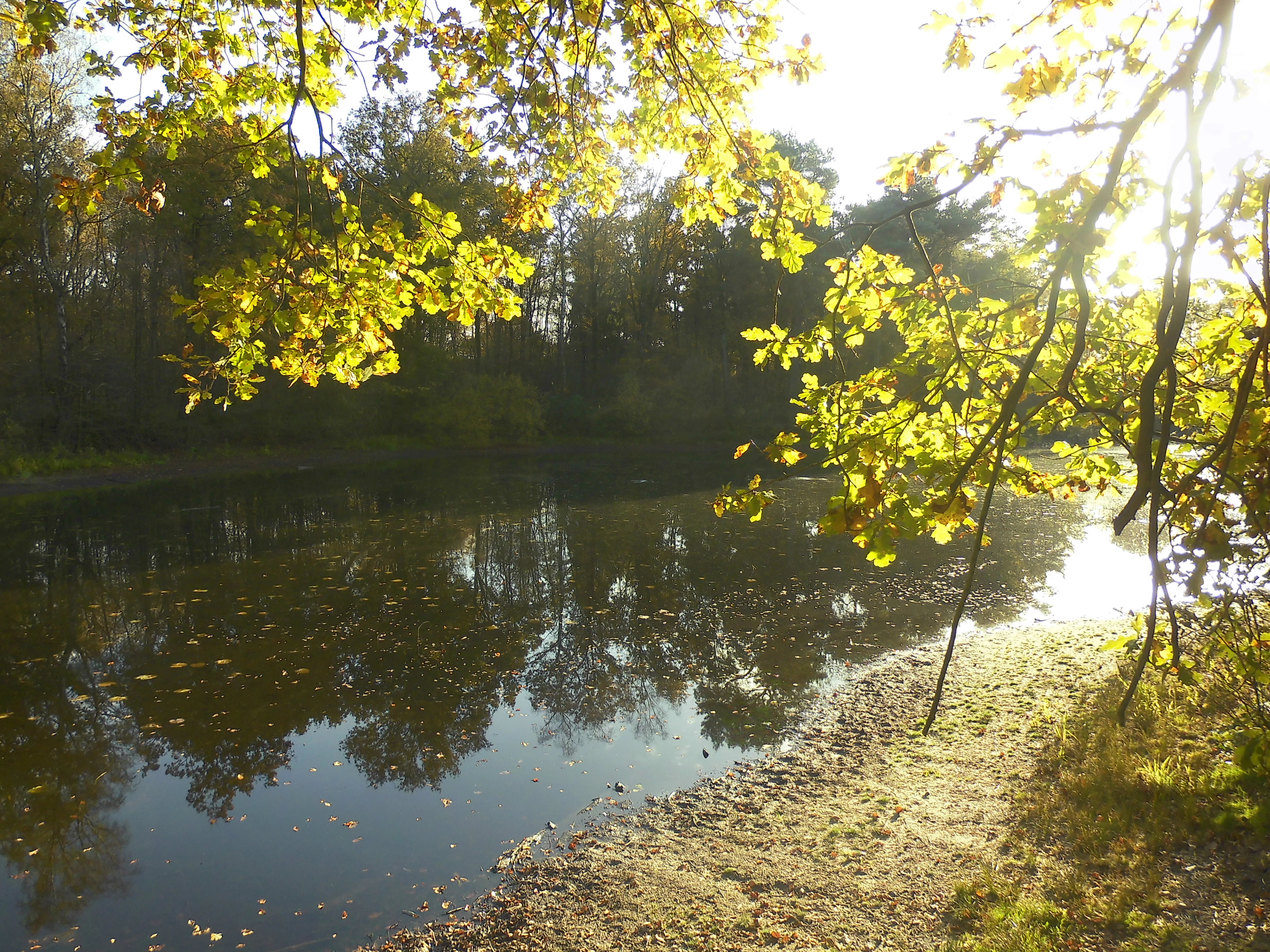
A view of a calm, dark pond surface surrounded by trees with yellow and green foliage, with sunlight filtering through branches in the foreground.
The shoreline of Kranenmeer, a heath pond in North Rhine-Westfalen, captured during autumn.

Kranenmeer history and protected-area timeline

The Kranenmeer area was first officially designated as a nature reserve in 1950, giving it one of the longer histories of formal protection within the Kreis Borken district of North Rhine-Westphalia. The name of the site itself derives from a former farmstead known as the Kranenhof, which once stood in the immediate vicinity of the moor.

Over time, the protected boundary of the reserve was expanded well beyond the lake itself. While the initial designation focused narrowly on the waterbody and its immediate surroundings, the reserve now covers approximately 140 hectares, encompassing the surrounding moor, heath transition zones, and woodland patches that together form the broader wetland complex.

In addition to its national-level protection, a core zone of about 9 hectares was later recognized as part of the European Natura 2000 network under the Habitats Directive. This reinforced the site's importance within the international framework for protecting threatened habitats and species.

Kranenmeer landscape and geographic character

The landscape of Kranenmeer is defined by a small, shallow lake set within a gently undulating terrain typical of the Westmünsterland. The surrounding ground rises only modestly above the water level, so the lake appears nestled into a shallow basin surrounded by moor, wetland margins, and patches of heath rather than dramatic topographic features.

Beyond the immediate lakeshore, the protected area extends across a mosaic of wet and semi-dry habitats. Open moor and degraded heath areas give way to wet grassland fringes, sedge communities, and, on the eastern side, a well-developed alder carr woodland rooted in the wettest parts of the basin. The result is a landscape of subtle transitions rather than sharp contrasts, where vegetation patterns shift gradually with moisture and soil conditions.

The broader setting is shaped by the agricultural countryside of the western Münsterland, with farms, fields, and scattered farmsteads surrounding the reserve. An old country lane skirts the western edge of the protected area, hinting at older routing patterns but carrying little modern traffic. Hydrologically, the lake feeds small unnamed drainage ditches that ultimately connect through the Kalten Bach and the Hammbach to the Lippe river system to the south.

Kranenmeer ecosystems, habitats, and plant life

Ecologically, Kranenmeer is best understood as a surviving fragment of a once more widespread heath moor ecosystem. The wetland complex combines open water with a range of marginal and terrestrial wetland communities, including vegetation types that have been heavily reduced elsewhere in the lowlands of northwestern Germany.

The lakeshore supports characteristic moor and bog plant communities, including rush-dominated lawns, water pennywort stands, and significant populations of frogbit. These aquatic and semi-aquatic plant communities form the foundation of the habitat mosaic, and their presence reflects the relatively undisturbed hydrology of the site.

Terrestrial wetland vegetation gives way on the eastern side of the lake to a compact and well-developed alder carr woodland, a community typical of permanently waterlogged peat soils. Within this woodland, stands of marsh violet add an additional botanical interest. Together, the combination of open water, bog vegetation, and alder carr creates a layered wetland landscape unusually rich for such a small reserve.

Kranenmeer wildlife and species highlights

Kranenmeer supports populations of several amphibian and dragonfly species that are considered rare or highly endangered in Germany, making it an important refuge for wetland fauna in the Westmünsterland. Among the amphibians recorded at the site, the moor frog stands out as a particularly characteristic species of undisturbed heath moors, while the crested newt represents another notable presence in the still, shallow waters of the lake.

The dragonfly fauna is similarly significant, including the small redeye, a delicate species associated with well-vegetated standing water, and the shiny hawker, one of the more striking representatives of bog pools in northwestern Germany. The presence of such species underscores the value of the site for invertebrates that depend on specific hydrological and vegetation conditions, which the reserve continues to provide.

Together, the amphibian and dragonfly assemblages at Kranenmeer illustrate how a very small wetland fragment, when sufficiently undisturbed, can sustain communities of conservation interest that have been lost from much of the surrounding agricultural landscape.

Kranenmeer conservation status and protection priorities

Kranenmeer has been protected as a nature reserve since 1950, making it one of the older conservation designations in the Kreis Borken area. Its protected status initially focused on the lake and its immediate surroundings, but the designation has since been expanded to cover a much larger area of associated moor and heath habitat, now totaling roughly 140 hectares.

A core area of around 9 hectares, encompassing the lake and its direct surroundings, is additionally designated as the FFH-Gebiet DE-4207-303 Kranenmeer under the European Union Habitats Directive. This inclusion in the Natura 2000 network reflects the international conservation significance of the site, particularly for its populations of endangered amphibians and dragonflies.

The conservation value of Kranenmeer lies largely in the rarity of its habitat type within the regional landscape. Heath moors have been heavily reduced across the Westmünsterland through drainage, agricultural conversion, and peat extraction. By preserving an intact example of this wetland complex along with its characteristic open water, Kranenmeer helps maintain regional biodiversity and serves as a reference site for understanding the area's original ecological character.

Top sights and standout views in Kranenmeer

Kranenmeer stands out for the unusually well-preserved combination of open water, bog vegetation, and adjacent alder carr woodland within a small area. Its significance lies less in size than in the integrity of a habitat type that has become rare in the Westmünsterland.

The reserve's inclusion in the European Natura 2000 network highlights its role in protecting species of broader continental concern, particularly amphibians and dragonflies associated with undisturbed small-scale wetlands. The setting, framed by traditional rural landscapes of the Münsterland, adds a quiet historical dimension to the visit experience.

Best time to visit Kranenmeer

Spring and early summer are the most rewarding periods to experience Kranenmeer, when moisture levels in the moor remain high, amphibian breeding activity peaks, and dragonfly emergence becomes visible around the open water. Late summer can offer quieter observation of wetland vegetation, while autumn tends to bring muted colors across the surrounding heath and bog fringes without the intensity of breeding-season wildlife displays.

Monthly climate preview

Long-term temperature and precipitation patterns recorded at representative park coordinates

Kranenmeer Climate Normals and Annual Weather by Month

Kranenmeer records long-term average monthly temperatures ranging from 1.56 degrees Celsius to 18.43 degrees Celsius alongside consistent daily precipitation measurements. Examining the complete twelve-month climatology profile reveals detailed seasonal variations in regional temperature and precipitation across the park.
Annual mean10 °C
2 °C18 °C
Jan
Feb
Mar
Apr
May13°
Jun16°
Jul18°
Aug18°
Sep15°
Oct10°
Nov
Dec
Warmest month
July

18.4 °C

Coolest month
January

1.6 °C

Wettest month
December

2.5 mm/day

Driest month
April

1.5 mm/day

Park location guide

Geography guide, regional context, and park location map for Kranenmeer

Kranenmeer park geography, regions, and map view in Germany

Understand where Kranenmeer sits in Germany through a broader geographic reading of the surrounding landscape, nearby location context, and its mapped position within the national park landscape.

How Kranenmeer fits into Germany

Germany is a federal republic in Western and Central Europe with a population of over 83 million across sixteen constituent states. It is Europe's largest economy by nominal GDP and a major global exporter and importer. The capital is Berlin, and the country borders Denmark, Poland, Czech Republic, Austria, Switzerland, France, Luxembourg, Belgium, and the Netherlands.

Wider geography shaping Kranenmeer in Germany

Germany is located in Western and Central Europe, spanning 357,022 km². It borders Denmark to the north, Poland and the Czech Republic to the east, Austria and Switzerland to the south, and France, Luxembourg, Belgium, and the Netherlands to the west. The country has coastlines on the Baltic Sea and North Sea to the north, with the Alps located in the southern region.

Map view of Kranenmeer

Use this park location map to pinpoint Kranenmeer in Germany, understand its exact geographic position, and read its mapped placement within the surrounding landscape more clearly.

Pigeon | © OpenStreetMap contributors

Location context for Kranenmeer

Nordrhein-Westfalen
Recorded earthquake history

View Historical Seismic Records and Earthquake Data for the Kranenmeer Nature Reserve

Review a comprehensive collection of recorded earthquakes associated with Kranenmeer. This MoriAtlas catalogue provides insight into regional seismic history through verified magnitude, depth, and distance data, ensuring a clear and grounded perspective on past local ground motion events.

Kranenmeer Earthquake History

Catalogued events

76 events

Strongest magnitude

Magnitude 4.6

Most recent event

Jul 24, 2009

This history includes earthquakes recorded inside the park or within 50 km of its borders

Explore the unique terrain, bog habitats, and wetland landscapes defining the nature reserve.

Kranenmeer Photos and Protected Area Scenery: Visualizing the Westmünsterland Heath Moor

Visual documentation of Kranenmeer reveals the subtle textures of its shallow lake, surviving heath moor, and surrounding alder carr woodland. Examining these protected habitats provides a clearer understanding of the rare wetland ecology preserved in the Westmünsterland region.

A view of a calm, dark pond surface surrounded by trees with yellow and green foliage, with sunlight filtering through branches in the foreground.

Park atlas

Compare adjacent wetland habitats and regional lowland reserves across the surrounding landscape

Explore Protected Areas and Parks Near Kranenmeer in Western Münsterland

Visitors exploring Kranenmeer can continue into nearby protected areas to examine similar heath moor and wetland habitats across the region. Reviewing adjacent reserves provides valuable geographic context on lowland conservation networks and regional landscape patterns.
A watercolor painting showing a soft green rolling landscape, a winding stream in the foreground, and distant hills under a white background.
Protected landscapeGermany
About 7.1 km away#1 closest

South

Naturpark Hohe Mark: Protected Landscape and Regional Geography Overview

Mapped terrain in North Rhine-Westphalia, Germany.

Gain insight into the complex topography of Naturpark Hohe Mark, an expansive protected area characterized by its transition from sandy upland forests to wetland-rich river valleys. This detailed overview covers the essential landscape features, regional boundaries, and ecological diversity that distinguish the park as a key geographical entity in Germany.

Area
1,978 km²
Established
1963
Relief
Mixed relief
Climate
Temperate
Nature reserveNorth Rhine-Westphalia
10 km away#2 closest

Southwest

Lichtenhagen Nature Reserve: Protected Lowland Landscapes and Habitat Geography in Wesel

A critical habitat mosaic for regional reptile and amphibian populations.

Lichtenhagen constitutes a distinct protected site within the Lower Rhine region, showcasing a unique ecological transition between heathland, still-water basins, and oak-dominated woodland. This former industrial site provides a protected refuge for the common European adder, smooth snake, and grass snake, representing a crucial case study in landscape restoration and regional conservation within North Rhine-Westphalia.

Area
1.1 km²
Established
1981
IUCN
IV
Watercolor painting of a green wetland area with a stream, soft hills in the background, and sparse trees.
Nature reserveNordrhein-Westfalen
About 13 km away#3 closest

Northeast

Heubachwiesen (BOR) Nature Reserve: Exploring the Heubach Stream Floodplain Geography

Wetland ecosystems and protected lowland terrain in western Münsterland.

This nature reserve in Nordrhein-Westfalen consists of four separate parcels characterized by flat wet meadows and shallow water features. As a protected area integrated into the EU Birds Directive, Heubachwiesen (BOR) serves as a vital refuge for threatened bird species and rare plant communities within the open, low-lying landscape of the Heubach floodplain.

Area
4.66 km²
Established
1982
IUCN
IV
Nature reserveNordrhein-Westfalen
About 13 km away#4 closest

Northeast

Wildpferdebahn Nature Reserve: Geography and Protected Habitat of the Merfelder Bruch

Explore the historic horse range in Nordrhein-Westfalen

Located in the Merfelder Bruch, the Wildpferdebahn protects 500 hectares of diverse terrain ranging from dry grasslands to damp alder woodlands. This nature reserve supports a self-sustaining herd of semi-feral horses, maintaining a landscape character that has persisted for generations. Learn about the reserve's role in conserving Westphalian wilderness traditions alongside sensitive moor and heath habitats.

Area
3.6 km²
Established
1847
Relief
Lowland
Access
Easy access
A watercolor painting showing a soft, pastoral landscape with green rolling hills, distant pinkish-hued mountains, and small clusters of trees.
Nature reserveNordrhein-Westfalen
About 17 km away#5 closest

Northeast

Kuhlenvenn Nature Reserve: Geographic Insights and Wetland Protection in Germany

A vital bird refuge within the Münsterland landscape

Kuhlenvenn is a 67 hectare nature reserve situated in the western Münsterland. Originally formed through industrial sand extraction, this area now features a rich habitat mosaic of meadows, wet grasslands, and shallow pools. It serves as a key regional center for migratory and breeding bird species, demonstrating how restored landscapes provide essential refuge in the broader North Rhine-Westphalia geography.

Area
0.67 km²
Established
1988
IUCN
IV
Relief
Lowland
Watercolor illustration of a pond in a moorland landscape with soft green hills and trees in the background.
Nature reserveNorth Rhine-Westphalia
About 18 km away#6 closest

Northeast

Heidesee Nature Reserve: A Protected Heathland and Bog Mosaic in North Rhine-Westphalia

Geographic landscape mapping of the Coesfelder Heide

Heidesee preserves a compact, high-value ecosystem featuring acidic water, sphagnum moss cushions, and rare carnivorous plants. Located within the glacial-sandy terrain of the Coesfelder Heide, this nature reserve offers a look at preserved wetland habitats and regional biodiversity management in western Germany.

Area
0.052 km²
Established
1985
IUCN
IV
Access
Moderate access
Nature reserveNetherlands
19 km away#7 closest

Northwest

Wooldse Veen Nature Reserve: Mapped Geography and Protected Bog Landscapes in the Netherlands

A transboundary peatland system in Gelderland.

Wooldse Veen preserves a rare fragment of raised bog and peatland habitat in the Dutch-German borderlands. The reserve features restored bog pools, historic smugglers paths, and a mosaic of heathland and birch woodland that reflects the regional geography of the Winterswijk National Landscape.

Area
1.5 km²
Established
1949
Relief
Lowland
Climate
Temperate
Nature reserveNorth Rhine-Westphalia
24 km away#8 closest

Southwest

Kaninchenberge Nature Reserve: Inland Dunes and Heathland Geography in North Rhine-Westphalia

Mapped protected landscapes of the Lower Rhine

Kaninchenberge preserves a rare inland dune system and surviving heathland within the North Rhine-Westphalia region. This protected area features a layered mosaic of pine-mixed forests and nutrient-poor grasslands, serving as a critical habitat fragment integrated into the European Natura 2000 network. Gain deeper insight into the geomorphology and protected ecosystem boundaries of this unique German site.

Area
1.06 km²
Established
1989
IUCN
IV
Relief
Lowland

Common questions about visiting, size, designation, and location context for Kranenmeer

Kranenmeer FAQs for park facts, access, geography, and protected area context

Find quick answers about Kranenmeer, including protected-area facts, park geography, trail and visitor context, and how the park fits into its surrounding country and regional landscape.
MoriAtlas Explorer

Continue Your Protected Areas Search Across the Global Atlas

Deepen your exploration by continuing the structured search for national parks and protected areas worldwide. Utilize the comprehensive filtering capabilities to compare different conservation landscapes and refine your understanding of global park geography. Discover more about the distribution and characteristics of protected natural areas.

Global natural geography