
Mori Atlas logo
Protected areaLafnitztal

A naturally meandering riparian landscape spanning Styrian hills and Pannonian floodplains

Lafnitztal Protected Area and Mapped River Geography in Southeastern Austria

Lafnitztal encompasses a remarkably preserved river corridor that transitions from the Alpine foothills of Styria into the open lowland terrain of eastern Austria. This protected area provides a vital map of meandering waterways, expansive oxbow remnants, and dense floodplain forests that define the regional geography of the Lafnitz river basin. Researchers and observers can trace the evolution of this natural riparian ecosystem from the Joglland highlands down toward the borderlands.

wetlandsriver valleyRamsar siteNatura 2000floodplain forestmeadow habitats
A flat-design, vector-style illustration of a mountainous valley. A waterfall descends from a rocky cliff into a winding river in the center. The foreground features stylized grass and tree trunks. The overall color palette uses muted greens, yellows, and soft pinks.

Lafnitztal

Protected area

Park overview

Structured park overview, official facts, and landscape profile for Lafnitztal

Lafnitztal park facts, protected area profile, and essential visitor context

Review the core facts for Lafnitztal, including designation, size, terrain, visitor scale, habitats, and operating context in one park-focused overview.

About Lafnitztal

The Lafnitztal is a southeastern Austrian river landscape defined by the course of the Lafnitz, a 114-kilometre left tributary of the Raab that ultimately flows into the Danube. The valley begins in the Joglland region of Styria, where the Lafnitz rises as the Lafnitzbach near Wenigzell, just east of the Kreuzwirt, on the Masenberg ridge. From these wooded highlands the river descends about 706 metres in elevation before reaching the East Styrian hill country.

At the municipality of Lafnitz, the Lafnitz assumes a broader geographic role, becoming the state border between Styria and Burgenland. This border function continues through much of the river's middle course, past Neudau, Burgau, Deutsch Kaltenbrunn, Rudersdorf, and Königsdorf. Near Rudersdorf the Lafnitz briefly forms the border with Hungary before crossing into Hungary itself and joining the Raab close to Szentgotthárd.

The most remarkable stretches of the Lafnitztal are its near-natural sections. South of the village of Lafnitz, the valley floor is sparsely populated, and the river continues to meander in a largely unregulated state through meadows, pastures, and softwood floodplain woodland. The so-called Fronius Auen between Rudersdorf and Fürstenfeld are a particularly noteworthy example of this preserved character, while the meander reach near Loipersdorf, with the large pastures known locally as the Alm im Tal, adds further ecological and cultural value.

Long recognised for its exceptional river ecology, the Lafnitztal was named River of the Year in 1996 by the Austrian Nature Conservation Union and partner organisations. This recognition laid the groundwork for its formal international designation as a Ramsar Convention wetland in 2002, marking it as the eleventh of Austria's nineteen Ramsar sites. The valley is also established as a Natura 2000 area along the full length of the river, providing an additional layer of European conservation protection.

Protection and recognition

Examine official terrestrial protection records and international wetland designation data for Lafnitztal.

Lafnitztal Protection Status, Ramsar Recognition, and Terrestrial Scope

Lafnitztal holds documented terrestrial protection status alongside verified Ramsar wetland recognition in international databases. Professional atlas research benefits from reviewing these structured conservation designations and official administrative boundaries.

International recognition

Protection details

Protection scope
Terrestrial
Transboundary protection
No
Park context

Deeper park guide and search-rich context for Lafnitztal

Lafnitztal history, landscape, wildlife, and travel context

Explore Lafnitztal through its history, landscape character, ecosystems, wildlife, conservation priorities, cultural context, and seasonal travel timing in a structured park guide built for atlas discovery and search intent.

Why Lafnitztal stands out

The Lafnitztal is best known as one of Austria's most naturally preserved lowland river valleys, where the Lafnitz still meanders through almost untouched floodplains. Since 2002 it has carried international recognition as a Ramsar wetland, protecting habitats such as moorgrass meadows, tall herb floodplain vegetation, and remnant alluvial forests. The valley also stands out for its rare and relict species, from the water chestnut and lung gentian to the kingfisher, black stork, and large blue butterfly of the great burnet. These species communities give the Lafnitztal a character more typical of Central European lowland rivers before widespread regulation, making it a key reference site for riverine conservation in Austria.
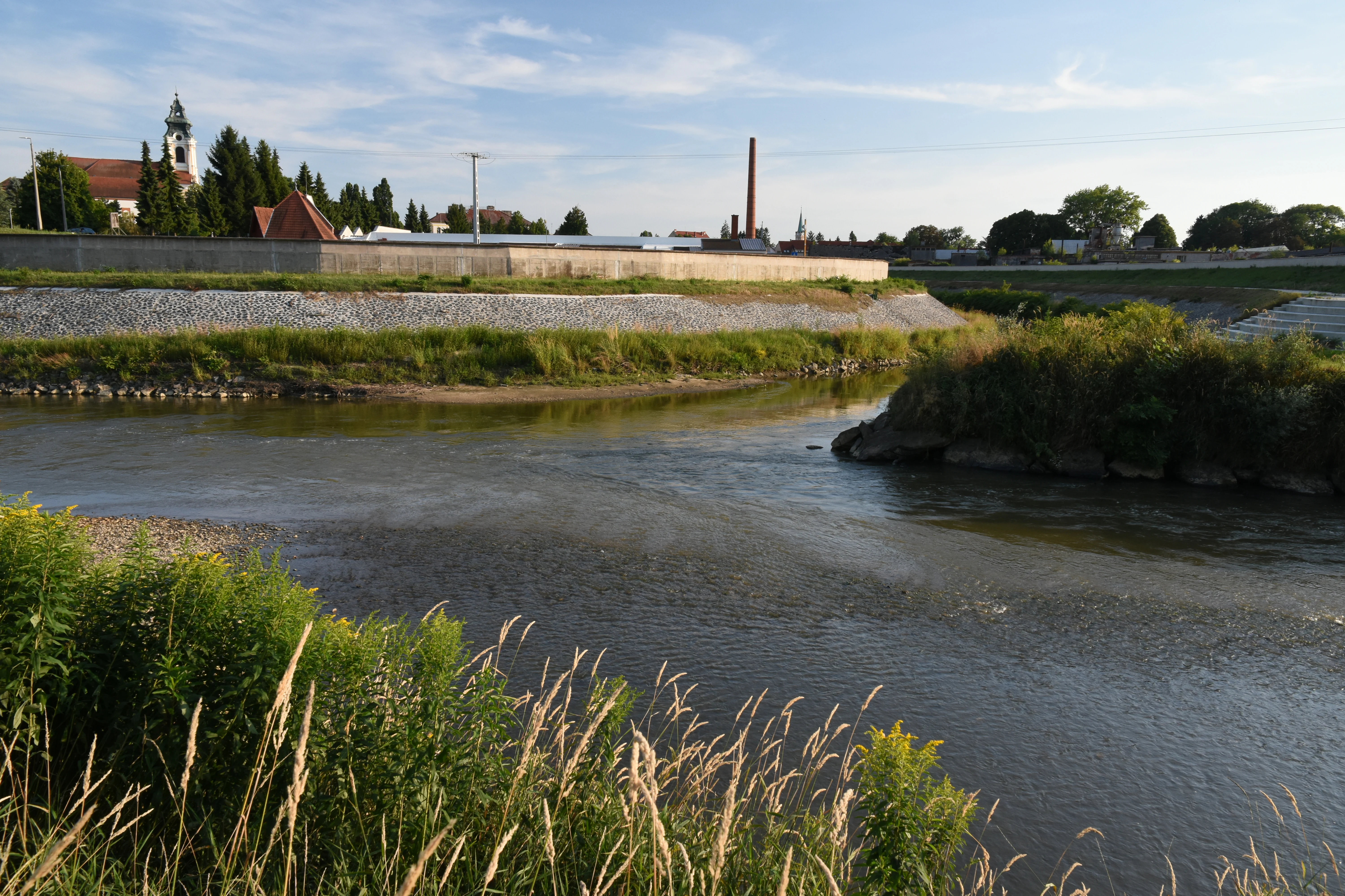
A river confluence where two waterways join, featuring a grassy embankment and a church tower visible in the background.
The confluence of the Lafnitz and Raab rivers near Szentgotthárd.

Lafnitztal history and protected-area timeline

The Lafnitz itself has a documented history going back more than a millennium, first recorded in 864 under the name Labenza. The origin of the name is attributed to a Celtic river designation, *Albantia, meaning something like 'white water', which was later reshaped through Slavic linguistic influence into its modern form.

For centuries, the Lafnitz served as a political border. It was historically the boundary between Austrian and Hungarian territories, and it remains today the boundary between the federal states of Styria and Burgenland. Burgenland itself only became a separate Austrian federal state in 1921, having previously been part of western Hungary. Empress Maria Theresa ordered numerous boundary stones to be set along the river from 1760 onward, several of which still survive. They were placed because the meandering Lafnitz frequently shifted its course, repeatedly provoking border disputes between the neighbouring lands.

In the twentieth century, sections of the river were regulated, including works during the 1970s in the Neudau and Burgauberg-Neudauberg municipalities that straightened part of the channel. By 2010, the affected municipalities decided to restore the historical link between the state border and the active river course. After extensive technical, legal, and political review, the border adjustment became legally binding in early 2021, meaning that all land left of the river in that section now belongs to Burgenland, while all land to the right belongs to Styria. Burgenland's territory thereby grew by roughly 6,000 square metres.

The valley's modern conservation history began in 1996, when the Lafnitz was recognised as River of the Year by Austria's leading nature protection organisations. Six years later, in 2002, it received international protection through its designation as a Ramsar Convention wetland, and the entire river has since been incorporated into the European Natura 2000 network.

Lafnitztal landscape and geographic character

The Lafnitztal describes a transitional landscape between Alpine foothills and Pannonian-influenced lowlands of eastern Austria. In its upper reaches, the valley takes shape within the Joglland hills of Styria, around the Masenberg ridge and the Vorauer Hochbecken near Vorau. As the river descends toward Rohrbach an der Lafnitz, it breaks out of the Eastern Alps into the East Styrian hill country, a gentler Riedelland of rolling terrain and broader valley floors.

From the municipality of Lafnitz southward, the valley is unusually open and sparsely settled. The river meanders freely across a softwood floodplain landscape, with wide meadows, oxbow remnants, and elevated terraces forming part of the visual character. The most striking landscape features are the meander reach near Loipersdorf to the south, and the Fronius Auen between Rudersdorf and Fürstenfeld further downstream, where the river corridors retain an almost unmodified character.

Wooden footbridges, historic boundary stones from the Maria Theresa era, and the locally famous fish-belly bridge, or Zeilbrücke, near Rohrbach, are characteristic landmarks of the valley. Its visual identity overall is defined by the contrast between the close-canopied forest and shrub thickets of the meander zone and the expansive pastoral meadows and pastures of the broader floodplain.
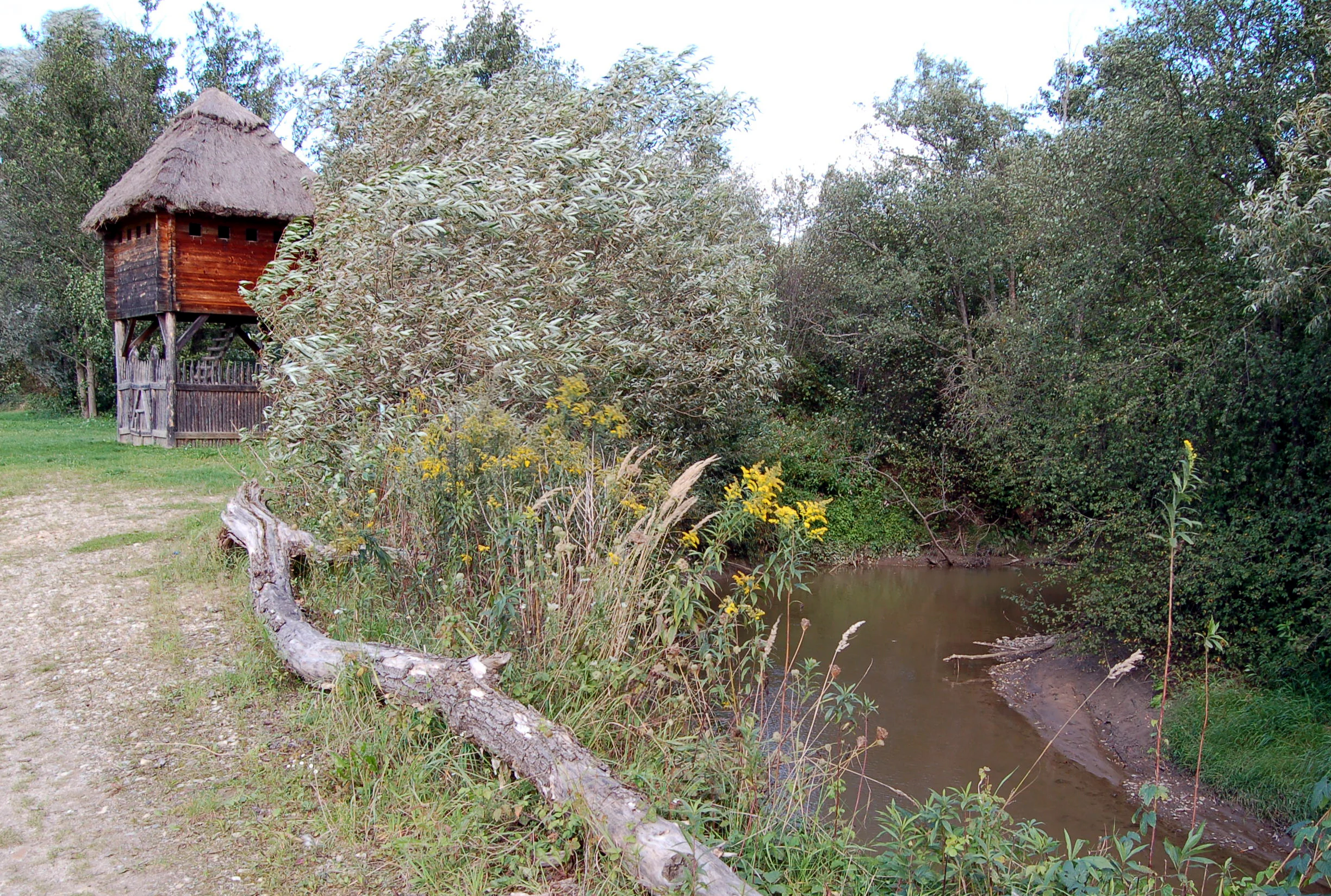
A rustic wooden guard hut with a thatched roof stands on a grassy bank next to a small, calm river winding through a wooded area.
A reconstructed historic tschartake guard hut alongside the Lafnitz river.

Lafnitztal ecosystems, habitats, and plant life

Ecologically, the Lafnitztal is one of Austria's most valuable lowland river ecosystems. The river corridor preserves a sequence of increasingly rare Central European floodplain habitats, including alluvial forests (Auwälder), tall-herb floodplain vegetation (Hochstaudenfluren), and especially the protected moorgrass meadows (Pfeifengraswiesen), which are among the most threatened grassland types in the region.

Vegetation along the valley reflects this gradient from upland forest to lowland meadow. Aquatic and wetland plant communities support relict species such as the water chestnut (Trapa natans), which persists in the calmer water bodies, alongside terrestrial meadow species such as the lung gentian and the globeflower, which colour the wet meadows in late spring and early summer.

Pastures in the valley are particularly significant for biodiversity conservation. Large open meadows near Loipersdorf, known locally as the Alm im Tal, sustain both wildlife and traditional grazing. As conventional cattle grazing declined in southern Burgenland and adjacent Hungary, conservation grazing using hardy cattle breeds such as Angus and Galloway, marketed locally as Zickentaler Moorochsen, has been reintroduced to keep the meadows open and ecologically valuable. Burgenland's traditional pasture goose, the Burgenländische Weidegans, has also benefited from the renewed use of these pastures.

Lafnitztal wildlife and species highlights

The Lafnitztal's near-natural river character makes it especially important for wildlife. Its combination of open water, riparian woodland, wet meadows, and undisturbed banks provides habitat for several rare Central European species.

Birds are among the most conspicuous elements of the valley's fauna. The kingfisher (Alcedo atthis) is regularly observed along the quieter stretches of water, while the black stork (Ciconia nigra) uses the valley's mature riparian forest and wet meadows as feeding habitat. Together, these species indicate the area's continued ecological integrity and its value for riparian bird conservation.

Insects are also closely tied to the valley's preserved meadows. The large blue butterfly of the great burnet (Heller Wiesenknopf-Ameisenbläuling, Maculinea teleius) depends on the specific combination of Sanguisorba officinalis host plants and the right species of ant, both of which the Lafnitz meadows continue to support. This butterfly is widely regarded as a flagship species of damp meadow conservation in Central Europe. Mammals, amphibians, and fish likewise benefit from the unbroken continuity of the river corridor, although many of these communities have been less intensively documented than the valley's more iconic bird and butterfly species.

Lafnitztal conservation status and protection priorities

The Lafnitztal is one of the strongest examples of integrated river conservation in Austria. Its recognition in 1996 as River of the Year by the Austrian Nature Conservation Union (Österreichischer Naturschutzbund) and partner organisations gave early impetus to coordinated protection efforts along the Lafnitz.

In 2002, the valley became Austria's eleventh Ramsar Convention wetland, with reference number 1169, placing it within an international network of protected wetlands of outstanding ecological value. The entire Lafnitz has also been designated a Natura 2000 site, bringing European Union-level habitat and species protection to the valley's meadows, forests, and river channels.

Conservation management along the Lafnitztal combines habitat protection with active land use. Conservation grazing with hardy cattle breeds such as Angus and Galloway, sometimes marketed regionally as Zickentaler Moorochsen, alongside the grazing of the Burgenländische Weidegans pasture goose, is used to preserve open meadow and pasture habitats that would otherwise lose their ecological value to succession. Together, these measures maintain the hydrology, vegetation, and species communities of a floodplain valley that has lost much of its character elsewhere in Central Europe.

Lafnitztal cultural meaning and human context

The Lafnitztal's cultural dimension is closely tied to its role as a historical borderland. For centuries the river marked the limit between Austrian and Hungarian territories, and it continues to mark the modern state border between Styria and Burgenland. Burgenland only became part of Austria in 1921, giving the river's border function a continuing cultural resonance.

Visible reminders of this border history include the surviving boundary stones placed by Empress Maria Theresa from 1760 onward, as well as the more recent political and legal effort, completed in 2021, to realign the state border with the river's actual course after twentieth-century regulation works. The river therefore carries not just ecological but also political and administrative significance for the region.

Traditional land use is part of the valley's identity as well. Large pastoral areas, locally known as the Alm im Tal near Loipersdorf, support seasonal grazing that long predates modern conservation. Reintroduced hardy cattle breeds and the Burgenland pasture goose reflect the way rural traditions have been adapted to the needs of habitat management, linking agricultural heritage with contemporary conservation practice.

Top sights and standout views in Lafnitztal

The Lafnitztal's strongest distinctions are its meandering, largely unregulated river course, its near-natural floodplain habitats of Auwald, Hochstaudenfluren, and Pfeifengraswiesen, and its rich relict flora and fauna, from water chestnut and globeflower to kingfisher, black stork, and the great burnet blue butterfly.

Best time to visit Lafnitztal

The Lafnitztal is most expressive in late spring and early summer, when the wet meadows of the valley floor are at their richest and the river corridor is fully active. This period brings the highest visibility for both flowering meadow species and the breeding-season birdlife along the river, including kingfisher and black stork.

Autumn offers quieter conditions and a different atmospheric character, with mature riparian forest colours and stable water levels that make walking and observation along the meander stretches particularly pleasant. Winter is generally the least favourable time for observing the valley's ecological richness, though the broader landscape remains scenically attractive.

Monthly climate preview

Long term temperature ranges and monthly precipitation patterns for Lafnitztal

Lafnitztal Climate Normals, Average Temperature and Precipitation Profiles

Representative coordinates record measured monthly temperature swings from sub-zero winter minimums to warm summer maximums alongside varying precipitation rates. Detailed monthly climate normals reveal the full annual weather rhythm across the protected landscape.
Annual mean7 °C
-3 °C17 °C
Jan-3°
Feb-2°
Mar
Apr
May11°
Jun15°
Jul17°
Aug17°
Sep12°
Oct
Nov
Dec-2°
Warmest month
July

17.1 °C

Coolest month
January

-3.3 °C

Wettest month
July

4.2 mm/day

Driest month
January

1.4 mm/day

Park location guide

Geography guide, regional context, and park location map for Lafnitztal

Lafnitztal park geography, regions, and map view in Austria

Understand where Lafnitztal sits in Austria through a broader geographic reading of the surrounding landscape, nearby location context, and its mapped position within the national park landscape.

How Lafnitztal fits into Austria

Austria is a landlocked country in Central Europe, bordered by Germany, Czech Republic, Slovakia, Hungary, Slovenia, Italy, Switzerland, and Liechtenstein. The country is a federal semi-presessional republic composed of nine states, with Vienna as its capital and largest city. It has a population of approximately 9.1 million people.

Wider geography shaping Lafnitztal in Austria

Austria is located in Central Europe, lying in the Eastern Alps. It is bordered by Germany and Czech Republic to the north, Slovakia to the northeast, Hungary to the east, Slovenia and Italy to the south, and Switzerland and Liechtenstein to the west.

Map view of Lafnitztal

Use this park location map to pinpoint Lafnitztal in Austria, understand its exact geographic position, and read its mapped placement within the surrounding landscape more clearly.

Pigeon | © OpenStreetMap contributors

Visualizing protected river valleys, meandering floodplains, and riparian habitats in Austria

Lafnitztal Photos and Mapped Landscape Scenery

Examine detailed park photography showcasing the winding river channels, expansive meadows, and alluvial forests defining the Lafnitztal protected area. Visual records illustrate the natural terrain, transitional lowland scenery, and delicate wetland habitats preserved across southeastern Austria.

A river confluence where two waterways join, featuring a grassy embankment and a church tower visible in the background.

A rustic wooden watchtower with a thatched roof stands on the edge of a small, narrow, meandering river flanked by dense green trees and foliage.

A rustic wooden guard hut with a thatched roof stands on a grassy bank next to a small, calm river winding through a wooded area.

Park atlas

Compare surrounding regional park geography and adjacent wetland conservation zones.

Parks Near Lafnitztal, Exploring Related Protected Areas and River Valleys

Browsing parks near Lafnitztal reveals connected lowland river valleys and protected habitats across eastern Austria. Comparing these adjacent reserves provides deeper insight into regional riparian landscapes and wetland preservation.
A stylized digital illustration of a mountainous landscape at sunset, featuring prominent steep limestone cliffs in the foreground and a vast valley extending into the distance under a warm-toned sky.
Nature reserveLower Austria
About 54 km away#1 closest

North

Hohe Wand Nature Park: Mapped Geography and Protected Landscapes in Lower Austria

A limestone plateau mountain at the Alpine-Pannonian transition

Located in Lower Austria, Hohe Wand Nature Park encompasses a distinct limestone plateau and dramatic southeastern cliffs. Its protected status reflects the convergence of Alpine and Pannonian geography, offering a unique opportunity to study karst geology, exposed cliff habitats, and the transition zone between high mountain ranges and the Vienna Basin lowlands.

Relief
Mountain
Climate
Temperate
Access
Easy access
Scope
Terrestrial
Watercolor illustration of green fields, trees, and distant hills
National parkHungary
About 57 km away#2 closest

Southeast

Őrség National Park: A Protected Landscape Explored Through Geographic Atlas Context

Mapped terrain, peat bogs, and ancient forests in Hungary.

As Hungary's youngest national park, Őrség National Park offers a distinctive protected landscape defined by rolling hills, ancient woodlands, and rare peat bogs. This entry provides detailed geographic context, mapping its boundaries and showcasing its natural terrain. Discover the unique ecosystem, shaped by centuries of traditional land use and its subalpine climate, presented within MoriAtlas for structured exploration and regional geographic understanding.

Area
440 km²
Established
2002
IUCN
II
Relief
Highland
Watercolor illustration of a landscape with green hills, a body of water, and trees under a soft sky
National parkGyőr-Moson-Sopron
About 70 km away#3 closest

Northeast

Fertő-Hanság National Park: Central European Wetland and Salt Lake Protected Area

Mapped Geographic Boundaries and Landscape Context

Fertő-Hanság National Park, situated in Győr-Moson-Sopron, Hungary, is a vital protected landscape renowned for its shallow salt lake and expansive marshlands. This page provides an atlas-focused discovery of its protected area, highlighting the unique interplay of reed beds and alkaline grasslands. Understand the park's geographic setting and its role as a significant wetland ecosystem for bird populations and specialized flora.

Area
235.88 km²
Established
1991
IUCN
II
Relief
Lowland
Watercolor painting showing a landscape with rolling terrain, water features, and distant mountains
National parkBurgenland
About 79 km away#4 closest

Northeast

Neusiedler See-Seewinkel National Park: Protected Steppe Lake Landscape in Burgenland

Explore mapped wetland geography and birdwatching significance.

Neusiedler See-Seewinkel National Park showcases a rare steppe lake environment and extensive wetland habitats at the eastern edge of Austria, within the Burgenland region. This protected area is globally recognized for its exceptional avian diversity and the unique ecological mosaic formed by reed beds, salt marshes, and seasonal pools. Explore its mapped boundaries and distinctive Pannonian geography for a deep understanding of this vital European protected landscape.

Area
97 km²
Established
1993
IUCN
II
Relief
Lowland
Protected landscapeLower Austria
About 79 km away#5 closest

North

Vienna Woods: Protected Landscape, Forested Highlands, and Alpine Foothill Geography

Natural terrain and protected boundaries in Lower Austria

The Vienna Woods encompass a distinct geographic region where sandstone ridges meet limestone formations. This protected landscape provides a dense network of forest habitats, river gorges, and significant peaks overlooking the Danube. Its structure traces the edge of the Alps, offering a rich study in regional geology, elevation gradients, and the intersection of natural wilderness with the surrounding basin environment.

Area
1,056.45 km²
Established
1987
Relief
Mountain
Climate
Temperate
National parkStyria
About 84 km away#6 closest

West

Gesäuse National Park: Detailed Protected Landscape and Alpine Geography in Styria

Explore Austria's dramatic river gorge and rugged peaks.

Gesäuse National Park in Styria represents a significant alpine protected area, characterized by the striking Enns river gorge cutting through the Gesäuseberge. This national park offers a unique geographic context, showcasing steep limestone peaks, dramatic rock faces, and a rich hydrological network. Discover the mapped boundaries and protected landscape of one of Austria's most visually striking natural passages, ideal for detailed atlas exploration and understanding alpine conservation.

Area
110 km²
Established
2002
IUCN
II
Relief
Mountain
Watercolor painting of a shallow lake scene with green reeds in the foreground, small trees on the shoreline, and rolling hills in the soft, hazy background.
Nature reserveAustria
About 87 km away#7 closest

Northeast

Lake Neusiedl: Protected Nature Reserve and Pannonian Steppe Geography in Austria

An endorheic lake system and critical wetland sanctuary.

Lake Neusiedl is a distinct nature reserve representing a rare European steppe lake environment. Its geography includes a vast ring of Phragmites reed beds, saline wetlands, and surrounding lowlands that form a vital migratory corridor. The lake serves as a cornerstone for protected landscapes in Austria, blending natural marshland dynamics with a deeply storied cultural history.

Area
315 km²
Established
1993
Relief
Lowland
Climate
Temperate
Protected areaStyria
About 97 km away#8 closest

West

Zirbitzkogel Protected Area: Mapping the Alpine Landscapes and Glacial Terrain of the Seetal Alps

High mountain geography and protected terrain in Styria, Austria

Zirbitzkogel represents the highest point of the Seetal Alps, characterized by crystalline geology, slate, and gneiss. The landscape features a clear progression from subalpine spruce and larch forests to broad, level summit plateaus covered in ragged sedge grasslands. Beyond its alpine vegetation and glacial tarns, the area serves as a critical protected habitat for diverse alpine fauna, offering an ideal setting for understanding regional alpine ecology and complex mountain landforms.

Established
2006
Relief
Mountain
Climate
Alpine
Access
Easy access

Common questions about visiting, size, designation, and location context for Lafnitztal

Lafnitztal FAQs for park facts, access, geography, and protected area context

Find quick answers about Lafnitztal, including protected-area facts, park geography, trail and visitor context, and how the park fits into its surrounding country and regional landscape.
MoriAtlas Explorer

Continue Your Protected Areas Search Across the Global Atlas

Deepen your exploration by continuing the structured search for national parks and protected areas worldwide. Utilize the comprehensive filtering capabilities to compare different conservation landscapes and refine your understanding of global park geography. Discover more about the distribution and characteristics of protected natural areas.

Global natural geography