Mori Atlas logo
Wildlife reserveLaguna Madre

Tracing the barrier islands, wetland ecosystems, and protected coastal geography of Tamaulipas

Laguna Madre: A Comprehensive Geographic Atlas of Mexico's Largest Hypersaline Coastal Lagoon

(Área de Protección de Flora y Fauna Laguna Madre y Delta del Río Bravo)

Laguna Madre stands as one of the world's most significant hypersaline lagoon systems, extending over two hundred kilometers along the northeastern coast of Mexico. Shielded from the Gulf of Mexico by a complex chain of sandy barrier islands, this protected wildlife reserve defines the ecological character of the Tamaulipas shoreline. Through our detailed mapping, observe the shallow lagoons, seagrass meadows, and arid thornscrub surroundings that constitute this globally vital Ramsar wetland and biosphere reserve.

hypersaline lagooncoastal lagoonGulf of MexicoTamaulipasbarrier islandsseagrass beds

Laguna Madre

Wildlife reserve

Park overview

Structured park overview, official facts, and landscape profile for Laguna Madre

Laguna Madre park facts, protected area profile, and essential visitor context

Review the core facts for Laguna Madre, including designation, size, terrain, visitor scale, habitats, and operating context in one park-focused overview.

About Laguna Madre

Laguna Madre is a defining natural feature of the Tamaulipas coast and one of the most ecologically distinctive coastal lagoons in the Americas. Running along the Gulf of Mexico for more than 200 kilometers between the Río Bravo delta and the mouth of the Soto la Marina River, the lagoon is bounded on its seaward side by a continuous chain of long, narrow barrier islands and on its inland side by the arid Tamaulipan plain. Together with the adjacent Laguna Madre in southern Texas, it forms one of only five hypersaline lagoon systems on Earth and is by far the largest, with a surface area approaching 5,900 square kilometers.

The lagoon's character is shaped by its unusual combination of extreme shallowness, restricted ocean access, and semi-arid climate. With an average depth of less than one meter and only a handful of narrow inlets currently connecting it to the Gulf of Mexico, Laguna Madre behaves more like a slowly evaporating inland sea than a typical coastal lagoon. Atmospheric conditions and prevailing winds dominate its circulation, and changes in freshwater inflow can swing its salinity from nearly fresh to more than three times that of open ocean seawater.

Despite these harsh conditions, Laguna Madre supports a rich coastal ecosystem. Its broad seagrass beds and salt-tolerant vegetation form the base of a productive food web that fuels Mexico's most important commercial shrimp fishery, while surrounding mangroves, dunes, and semi-arid thornscrub provide habitat for waterbirds, songbirds, raptors, and large mammals such as jaguuar, ocelot, and puma. The lagoon is internationally recognized for its birdlife, including wintering populations of redhead ducks, northern pintails, piping plovers, sanderlings, and other shorebirds, and it sits squarely on the Gulf migratory route used by waterbirds, raptors, and songbirds traveling between North America and the Neotropics.

Protected in 2005 as a Mexican flora and fauna protection area and in 2006 as a UNESCO biosphere reserve, Laguna Madre is treated today as a single ecological unit together with the surrounding delta and complementary habitats of the Tamaulipan pastizal. The site is also a designated Ramsar Wetland of International Importance, reflecting its global value as a coastal ecosystem.

Quick facts and research context for Laguna Madre

Laguna Madre lies along the coast of Tamaulipas in northeastern Mexico, within the municipalities of Matamoros, San Fernando, and Soto la Marina. It is the largest lagoon in Mexico, with a surface of roughly 5,700 to 5,850 square kilometers, and ranks as the world's largest and North America's only hypersaline lagoon system. The lagoon is protected as both a national flora and fauna protection area (designated 2005) and an international biosphere reserve (designated 2006), and was listed as a Ramsar Wetland of International Importance in 2004.

Protection and recognition

Documented protection history, management scope, and Ramsar site details for Laguna Madre

Laguna Madre Protection Status and International Recognition Data

Examine the documented protection status, designation history, and transboundary scope established for Laguna Madre since 2006. Official records outline mixed protection measures and verified Ramsar site recognition without implying specific management outcomes.

International recognition

Protection details

Protection scope
Mixed
Designated year
2006
Transboundary protection
Yes
Park context

Deeper park guide and search-rich context for Laguna Madre

Laguna Madre history, landscape, wildlife, and travel context

Explore Laguna Madre through its history, landscape character, ecosystems, wildlife, conservation priorities, cultural context, and seasonal travel timing in a structured park guide built for atlas discovery and search intent.

Why Laguna Madre stands out

Laguna Madre is best known for being one of only five hypersaline lagoon systems in the world and the single largest of them, a distinction that shapes its entire ecological character. Its combination of extreme salinity, shallow waters, extensive seagrass and mangrove habitats, and position on the Gulf of Mexico migratory flyway makes it a globally important wintering and nesting area for birds and one of Mexico's premier coastal shrimp fisheries. The lagoon is also defined by its barrier island chain, which nearly cuts it off from the open Gulf and has had a decisive effect on its salinity, circulation, and long-term drying pattern.
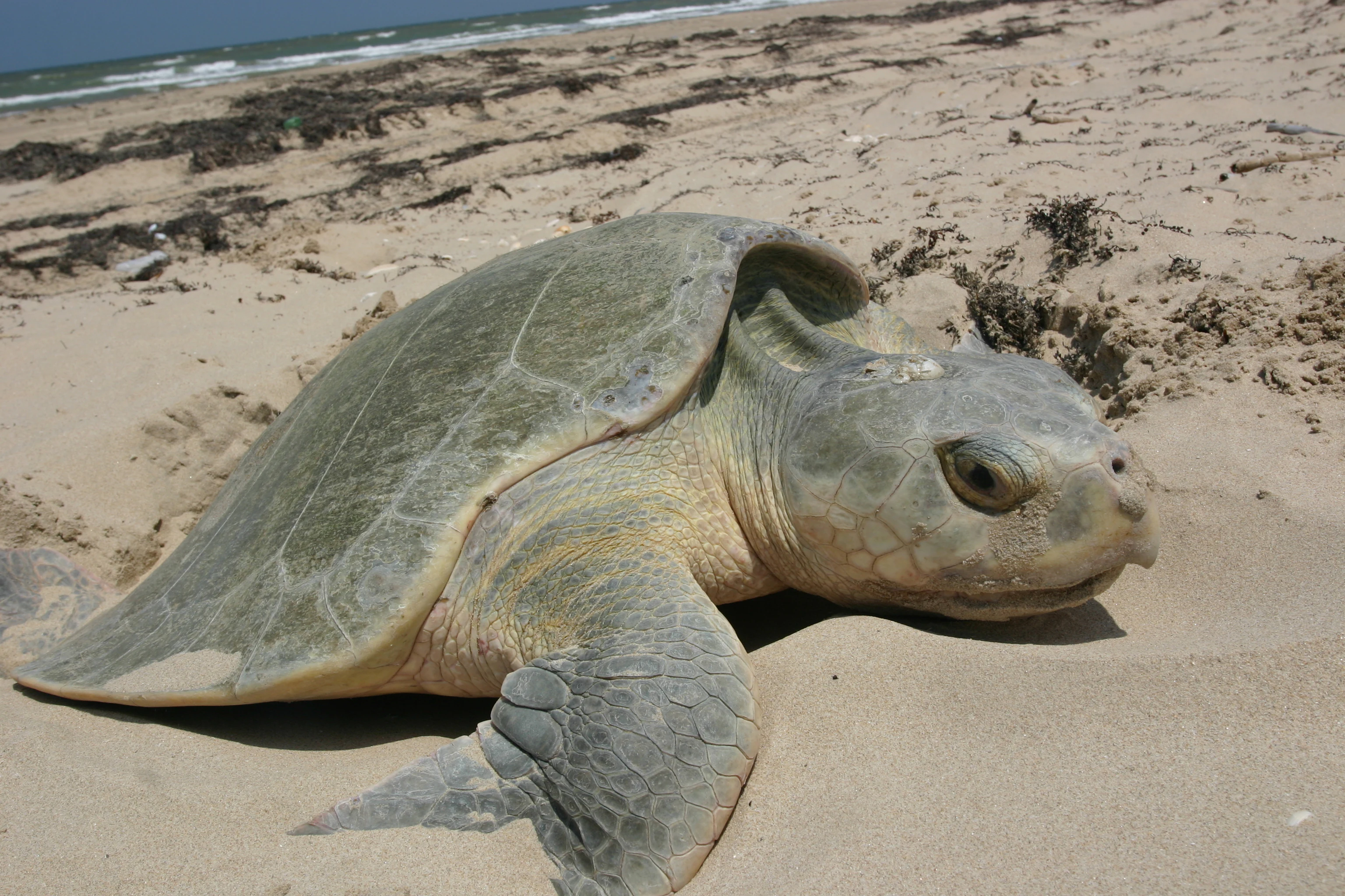
A Kemp's Ridley sea turtle resting on sandy beach with the ocean in the background.
A Kemp's Ridley sea turtle on a beach in the Laguna Madre region.

Laguna Madre history and protected-area timeline

The Laguna Madre lagoon system formed relatively recently in geological terms, developing over the last several thousand years as the Río Bravo repeatedly shifted its lower course before reaching the sea. The lagoon itself appears to have become effectively cut off from the Gulf of Mexico roughly three thousand years ago, after which it has been slowly concentrating salts through evaporation.

The Spanish reached the region in the 16th century and gave the lagoon its present name. Local resource use intensified in the early 20th century, when commercial fishing operations began along the coast, and freshwater withdrawals from the Río Bravo and the San Fernando River have progressively reduced inflows to the lagoon, accelerating its drying trend since the 1970s.

By the mid-20th century, the natural inlets connecting the lagoon to the Gulf had almost closed, isolating Laguna Madre from the open sea for decades. That changed dramatically in 1967, when Hurricane Beulah swept across the region and reopened the Mexican portion of the lagoon to marine exchange, an event that triggered a gradual recolonization of the lagoon by marine and estuarine species. Throughout the 1970s, jetties were constructed on the remaining inlets to stabilize the renewed ocean connection.

The lagoon's growing ecological importance, set against its steadily worsening condition, prompted a major conservation effort. After years of lobbying by organizations such as Pronatura Noreste, along with universities, local governments, and communities, the Mexican government declared more than half a million hectares of Laguna Madre and the Río Bravo delta a federal natural protected area in 2005, with UNESCO following in 2006 by recognizing the same landscape as an international biosphere reserve.

Laguna Madre landscape and geographic character

Laguna Madre occupies a long, narrow coastal corridor that mirrors the alignment of the Tamaulipas shoreline, with its barrier island chain, inland plains, and complex mosaic of shallow bays giving the system a gentle, low-relief character. The whole landscape lies under a semi-arid climate, where strong evaporation and limited rainfall shape both the water and the surrounding land.

The most visible physical feature of the lagoon is the chain of barrier islands that lines its seaward edge. From north to south, the principal bars include Barra del Conchillal, Barra de los Americanos, Barra de Jesús María, and Barra de Soto la Marina, each consisting of long sandy ridges aligned roughly parallel to the coast. These barrier islands, together with the few narrow inlets that pierce them, form the lagoon's only connection to the Gulf of Mexico and largely control its circulation.

Within the lagoon itself, the seafloor is exceptionally flat and dominated by clayey sediments, without major concentrations of gypsum or carbonate. The surrounding mainland is composed of low dunes, gentle plains, and rolling thornscrub terrain typical of the northeastern Mexican drylands. This flat, poorly drained topography, combined with the limited tidal exchange, is what allows the lagoon to maintain its characteristic hypersaline conditions.

Laguna Madre ecosystems, habitats, and plant life

The natural character of Laguna Madre is defined by its hypersaline waters and the highly specialized habitats that have evolved around them. Because the lagoon is nearly isolated from the open Gulf and sits in a semi-arid climate, evaporation continuously concentrates salts, creating a chemical environment that only specially adapted species can tolerate. Yet this harsh setting supports a remarkably productive and distinctive ecological system.

The lagoon floor is carpeted by resilient seagrass beds, with species such as Halodule wrightii and turtle grass (Thalassia testudinum) anchoring the benthic habitat and providing shelter for shrimp, fish, and other marine life. Around the shores, salt-tolerant vegetation gives way to mangroves, coastal wetlands, and inland thornscrub, forming a transitional mosaic between the open water and the Tamaulipan grasslands and semi-arid shrublands of the adjacent pastizal.

Vegetation patterns vary across the catchment. Mesquite, blackbrush, and other characteristic thornscrub shrubs dominate the uplands, while halophytic and aquatic plants stabilize the lagoon's margins. The combination of shallow hypersaline water, seagrass meadows, mangrove fringe, and arid thornscrub uplands makes Laguna Madre one of the most ecologically distinctive coastal landscapes in Mexico, and roughly half of the species found in the broader region are considered to have restricted geographic distributions.

Laguna Madre wildlife and species highlights

Laguna Madre supports one of the richest coastal avifaunas in Mexico. The lagoon and its associated wetlands host close to 150 bird species, and the surrounding thornscrub and grassland habitats add many more. About 3 percent of the birds recorded in the region are endemic to Mexico, and the lagoon is the only known regular breeding site in the country for the American white pelican (Pelecanus erythrorhynchos).

Roughly 26 species of waterfowl and shorebirds rely directly on the lagoon, including grey plover, sanderling, least sandpiper, and piping plover, alongside very large wintering populations of redhead ducks and northern pintails that can each exceed one hundred thousand individuals. The lagoon sits on a major segment of the Gulf of Mexico migratory route, and an estimated 15 percent of all bird species that migrate between Canada, the United States, and the south pass through the lagoon system. Among the most characteristic shorebirds are the western sandpiper and the dunlin.

Marine life is dominated by shrimp, which form Laguna Madre's principal commercial fishery. Brown shrimp and other penaeid species are most abundant in the less saline southern half of the lagoon, and the broader waters also support sea trout and black drum. Antillean-influenced fish species such as snooks and mojarras share the lagoon with temperate Gulf fauna, reinforcing its biogeographic distinctiveness.

Two species of sea turtle occur in the lagoon, the endangered Kemp's ridley (tortuga lora) and the green sea turtle (tortuga verde). The southern end of Laguna Madre is an important nesting area for Kemp's ridley, where nest counts suggest a slow but real recovery of the population. Upland habitats around the lagoon form a key wildlife corridor for large mammals, sustaining jaguar, ocelot, oncilla, puma, and bobcat across some of the best preserved tracts of Tamaulipan pastizal in Mexico.

Laguna Madre conservation status and protection priorities

Laguna Madre is one of the most important conservation landscapes along Mexico's Gulf coast. Its combination of hypersaline waters, barrier islands, mangroves, seagrass beds, and connected thornscrub grasslands gives it a distinctive ecological value that cannot easily be replicated elsewhere, and the lagoon's position on the Gulf migratory flyway makes it a critical node for hemispheric bird conservation.

The formal protection of the site emerged from sustained work by Pronatura Noreste, Mexican universities, municipal governments, and local communities who documented the lagoon's ecological importance and lobbied for stronger safeguards. In 2005, the Mexican government designated Laguna Madre and the Río Bravo delta as a federal flora and fauna protection area, covering roughly 1.4 million acres across the municipalities of Matamoros, San Fernando, and Soto la Marina. The following year, UNESCO recognized the same landscape as an international biosphere reserve, extending its protection status onto the global stage.

Beyond the federal designations, Laguna Madre was listed as a Ramsar Wetland of International Importance in 2004, underscoring its global standing as a coastal wetland of outstanding value. The combined international, national, and Ramsar recognitions reflect the lagoon's role as both a refuge for threatened species like the Kemp's ridley sea turtle and a working landscape, where traditional fisheries and conservation coexist within a single managed system. Ongoing concerns include reduced freshwater inflow from the Río Bravo and San Fernando rivers, the lagoon's slow loss of water through evaporation, and the need to keep its narrow ocean inlets open enough to maintain ecological exchange.

Laguna Madre cultural meaning and human context

Laguna Madre has been a working coastal landscape for centuries. The lagoon was first visited and named by Spanish explorers in the 16th century, and its long role in the regional identity of Tamaulipas is tied to traditional fishing communities along the barrier islands and shore. Although the lagoon's human population is small, the inland municipalities of Matamoros, San Fernando, and Soto la Marina each have deep historical roots in the surrounding coastal plain.

Fishing has shaped local livelihoods since the early 20th century, when commercial operations began in the lagoon. Today, commercial shrimp fishing remains the most economically important activity tied to Laguna Madre's waters, and the seasonal rhythm of the fishery forms a recurring cultural and economic thread for coastal Tamaulipas families. Conservation efforts that led to the lagoon's protected status in 2005 were explicitly driven by partnerships between these communities, regional NGOs, and academic institutions, reinforcing the sense of Laguna Madre as a shared regional heritage site rather than just a remote natural area.

Top sights and standout views in Laguna Madre

Laguna Madre's most compelling highlights cluster around its identity as the largest hypersaline lagoon in the world. Its barrier island chain, restricted ocean access, and shallow, salt-laden waters set it apart from virtually every other coastal lagoon system on Earth, while its associated seagrass meadows and mangrove fringes sustain an unusually productive biological community.

Birdlife is a defining highlight, with close to 150 species recorded in the broader protected area and very large wintering flocks of redhead ducks and northern pintails. The lagoon is also the only regular breeding site in Mexico for the American white pelican, hosts an important nesting area for the endangered Kemp's ridley sea turtle, and supports Mexico's largest commercial shrimp fishery on the Gulf coast.

Together, the lagoon's Ramsar status, federal flora and fauna protection designation, and UNESCO biosphere reserve recognition make it not just a regional landmark but a coastal ecosystem of hemispheric and global conservation significance.

Best time to visit Laguna Madre

Laguna Madre is a coastal and wetland system where the time of year strongly shapes the experience. The cooler, drier winter months bring the largest concentrations of migratory and wintering birds, including redhead ducks, northern pintails, and a wide variety of shorebirds, and generally offer milder temperatures for exploring the surrounding thornscrub and barrier island habitats.

Late spring and summer are the peak of the lagoon's commercial shrimp season, which extends roughly from March through September, when local fishing communities are most active on the water. These warmer months can be extremely hot, but they also offer the best chance to observe sea turtle nesting activity at the southern end of the lagoon. Because the lagoon's salinity, bird presence, and water levels all respond to rainfall patterns, visitors interested in wildlife generally find the cooler dry season most rewarding, while those interested in the working fishery will encounter the lagoon at its busiest during the warm months.
Monthly climate preview

Track multi-year monthly temperature averages and precipitation totals for Laguna Madre

Laguna Madre Climate Normals and Long-Term Temperature Patterns

Representative coordinate records show average monthly temperatures ranging from 18.76 °C to 28.83 °C alongside distinct multi-year precipitation variations across the year. Reviewing the complete twelve-month climate profile reveals comprehensive statistical breakdowns for long-term temperature ranges and monthly rainfall norms.
Annual mean24 °C
19 °C29 °C
Jan19°
Feb20°
Mar21°
Apr24°
May26°
Jun28°
Jul28°
Aug29°
Sep28°
Oct26°
Nov23°
Dec20°
Warmest month
August

28.8 °C

Coolest month
January

18.8 °C

Wettest month
September

5.4 mm/day

Driest month
February

0.7 mm/day

Park location guide

Geography guide, regional context, and park location map for Laguna Madre

Laguna Madre park geography, regions, and map view in Mexico

Understand where Laguna Madre sits in Mexico through a broader geographic reading of the surrounding landscape, nearby location context, and its mapped position within the national park landscape.

How Laguna Madre fits into Mexico

Mexico, officially the United Mexican States, is a country in North America spanning the Sierra Madre mountain ranges, coastal plains, and tropical regions. It borders the United States to the north, Guatemala and Belize to the southeast, and has coastlines along the Pacific Ocean, Gulf of Mexico, and Caribbean Sea. With a population exceeding 130 million, Mexico is home to one of the world's most significant concentrations of Indigenous languages alongside Spanish.

Wider geography shaping Laguna Madre in Mexico

Mexico occupies a land area of 1,972,550 km2, making it the thirteenth-largest country in the world. The terrain is highly diverse, featuring the Sierra Madre Occidental and Sierra Madre Oriental mountain ranges, the Mexican Plateau, coastal lowlands along the Pacific and Gulf/Caribbean margins, and the Yucatan Peninsula. The country spans multiple climate zones from desert in the north to tropical rainforest in the south.

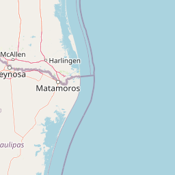
Map view of Laguna Madre

Use this park location map to pinpoint Laguna Madre in Mexico, understand its exact geographic position, and read its mapped placement within the surrounding landscape more clearly.

Pigeon | © OpenStreetMap contributors

Location context for Laguna Madre

Tamaulipas

Examine the barrier islands, shallow hypersaline waters, and protected habitats of northeastern Mexico.

Laguna Madre Photos and Visual Guide to Coastal Landscapes and Scenery

Visual documentation captures the vast coastal expanse, barrier island chains, and shallow hypersaline waters defining Laguna Madre. Examining protected habitats, seagrass meadows, and arid thornscrub terrain reveals the distinct environmental character of the region.

A Kemp's Ridley sea turtle resting on sandy beach with the ocean in the background.

Park atlas

Compare regional protected landscapes and discover adjacent coastal reserves.

Exploring Parks Near Laguna Madre and Related Coastal Protected Areas

Continue browsing other parks near Laguna Madre to examine similar coastal wetlands, barrier island chains, and arid lowland ecosystems. Expanding the geographic comparison reveals broader ecological patterns across the regional protected landscape.
A soft, watercolor-style illustration of a landscape with rolling dunes, sparse grasses, and a lone yucca plant.
Protected landscapeTexas
About 195 km away#1 closest

North

Padre Island National Seashore: Protected Barrier Island Geography and Mapping

Coastal landscapes and hypersaline lagoon ecosystems in South Texas

Padre Island National Seashore serves as a critical protected landscape on the Texas Gulf Coast, characterized by seventy miles of undeveloped shoreline and the hypersaline Laguna Madre. This atlas entry provides geographic context on the barrier island terrain, including active dune fields, tidal flats, and the diverse habitats that support significant migratory bird populations and sea turtle recovery efforts.

Area
527.85 km²
Established
1962
IUCN
V
Visitors
573.3K annual
Protected areaNuevo León
About 214 km away#2 closest

Northwest

Sierra de Picachos Protected Area: Geographic Boundaries and Regional Landscapes

Mountain geography in northern Nuevo León

Sierra de Picachos represents a vital conservation zone spanning north of Monterrey. The landscape is defined by its dramatic elevation changes, moving from desert-like plains to cool coniferous slopes. This atlas entry focuses on the physical boundaries, ecological zones, and the rugged, peak-studded terrain that distinguish the range from the surrounding Sierra Madre Oriental.

Area
1,405 km²
Established
2000
Relief
Mountain
Climate
Subtropical
Watercolor illustration showing a river flowing through green forest with pink mountains in the background on a white background
Protected areaTamaulipas
About 234 km away#3 closest

South

Sierra de Tamaulipas Protected Area: Geography, Karst Terrain, and Sky Island Ecosystems

Mapping the natural features of a remote Mexican mountain massif.

The Sierra de Tamaulipas offers a unique study in vertical geography and isolated ecosystems. Rising dramatically above the plains of Tamaulipas, this protected area features a complex mosaic of tropical deciduous forests and pine-oak summits. The range also hosts notable karst features, including the world's deepest water-filled sinkhole, El Zacatón, set within a landscape of immense historical and biological value.

Area
3,339 km²
Established
2016
Relief
Mountain
Climate
Subtropical
Watercolor illustration of layered mountain ranges with purple peaks fading into a green and yellow foreground.
Natural monumentNuevo León
About 268 km away#4 closest

West

Cerro de la Silla: Protected Natural Monument Geography and Regional Map Context

A rugged mountain landscape in Nuevo León, Mexico

Cerro de la Silla is defined by its unmistakable saddle-shaped silhouette and its status as a vital protected area within the urban matrix of Monterrey. The mountain features complex folded limestone geology and a diverse habitat mosaic that transition from arid scrubland to forested peaks. Use this atlas resource to understand its topographical boundaries, summit formations, and regional environmental significance within the Sierra Madre Oriental fold belt.

Area
60 km²
Established
1991
Relief
Mountain
Climate
Subtropical
National parkMexico
About 272 km away#5 closest

West

Cumbres de Monterrey National Park: National Park Protected Landscape Discovery

Explore Mexico's Mapped Terrain and Regional Geography

Understand Cumbres de Monterrey National Park as a distinct protected landscape within Mexico. This page provides detailed atlas-oriented information focused on its geographic boundaries, mapped terrain, and its role in regional conservation. It serves as a valuable entry point for exploring the park's natural context and understanding its place in the national geography.

Area
1,773.96 km²
Established
1939
IUCN
II
Relief
Mountain
Protected areaCoahuila
About 289 km away#6 closest

West

Cuenca Alimentadora del Distrito Nacional de Riego 026 Bajo Rio San Juan Protected Landscape

Mountain watershed and forest habitat in Coahuila

An expansive protected area encompassing the upper catchments of the San Juan River. The terrain features a significant altitudinal gradient, ranging from semi-arid matorral shrublands to rare high-altitude conifer groves including Mexican Douglas-fir, defining the regional water supply landscape.

Area
1,971.57 km²
Established
1949
IUCN
VI
Relief
Mountain
Nature reserveTexas
About 318 km away#7 closest

North

Mission-Aransas National Estuarine Research Reserve: A Texas Coastal Protected Landscape

Mapped estuarine habitats and regional coastal geography

Encompassing a unique mix of terrestrial and marine environments, Mission-Aransas National Estuarine Research Reserve stands as a significant protected corridor on the Texas Coast. The landscape features deep-water bays, sheltered seagrass meadows, and open coastal prairie, offering a clear view of how riverine processes shape the complex shoreline of the western Gulf of Mexico.

Relief
Lowland
Climate
Subtropical
Access
Easy access
Scope
Mixed
Watercolor painting of a mountain range featuring gentle slopes and low-lying shrubs against a white background.
Protected areaCoahuila
About 335 km away#8 closest

West

Serranía de Zapalinamé: Protected Mountain Geography and Watershed in Coahuila

Ecological transition zone within the Sierra Madre Oriental

The Serranía de Zapalinamé forms a dramatic mountain corridor rising over Saltillo, Coahuila. This state natural reserve protects a vital watershed and biodiversity hotspot where Chihuahuan Desert scrub meets pine and oak montane forests. Its steep canyons and high ridges offer a significant case study in regional landscape conservation and natural water security.

Area
253.74 km²
Established
1996
Relief
Mountain
Climate
Arid

Common questions about visiting, size, designation, and location context for Laguna Madre

Laguna Madre FAQs for park facts, access, geography, and protected area context

Find quick answers about Laguna Madre, including protected-area facts, park geography, trail and visitor context, and how the park fits into its surrounding country and regional landscape.
MoriAtlas Explorer

Continue Your Protected Areas Search Across the Global Atlas

Deepen your exploration by continuing the structured search for national parks and protected areas worldwide. Utilize the comprehensive filtering capabilities to compare different conservation landscapes and refine your understanding of global park geography. Discover more about the distribution and characteristics of protected natural areas.

Global natural geography