

Mori Atlas logo
Protected landscapeLake Alaotra

A detailed map and geographic exploration of Madagascar's largest freshwater basin and its essential wetland mosaic.

Lake Alaotra Protected Landscape and Wetland Geography in the Alaotra-Mangoro Region

Lake Alaotra represents a vital protected landscape situated on the central plateau of Madagascar. This expansive basin comprises a complex network of shallow freshwater lakes, marshlands, and reedbeds that define the hydrology of the surrounding Alaotra-Mangoro region. Through our map-focused atlas, users can examine the transition between these critical natural habitats and the agricultural rice paddies that characterize the broader catchment, providing a detailed look at one of the island's most ecologically significant wetland systems.

freshwater lakewetlandRamsar sitemarshlandreedbedsrice-growing region

Lake Alaotra

Protected landscape

Park overview

Structured park overview, official facts, and landscape profile for Lake Alaotra

Lake Alaotra park facts, protected area profile, and essential visitor context

Review the core facts for Lake Alaotra, including designation, size, terrain, visitor scale, habitats, and operating context in one park-focused overview.

About Lake Alaotra

Lake Alaotra is the largest freshwater lake in Madagascar and one of the most ecologically distinctive wetland systems in the western Indian Ocean region. It lies on a relatively high plateau section of the island's north-central interior, in the Alaotra-Mangoro region, and serves as the hydrological and agricultural heart of a vast catchment. The lake itself is a broad, shallow body of water, surrounded by an extensive apron of marshes, reedbeds, and rice paddies. Together, the lake and its surrounding wetlands form a habitat mosaic that, in regional terms, is exceptional in its extent and ecological complexity.

What sets Lake Alaotra apart is the way it sits at the intersection of human use and biodiversity. Its fertile alluvial plain has made it Madagascar's most important rice-producing region, supplying a significant share of the country's domestic rice harvest. At the same time, the lake and its marshes sustain several endemic species found nowhere else on Earth, including the Alaotra gentle lemur and a small group of plant and invertebrate taxa tightly linked to the reedbed and open-water habitats. The lake is also a major site for waterbirds, with both resident and migratory species relying on its open water and fringing vegetation.

Recognition of the wetland's importance came in 2003, when it was officially listed as a Ramsar Wetland of International Importance, encompassing the lake and the broader zones humides et bassins versants that feed into it. The designation underscored the global conservation value of the site even as the surrounding landscape was rapidly changing. Hills once covered in forest have been progressively cleared for cultivation, and the resulting erosion has caused widespread sedimentation of the lake basin, contributing to a steady shallowing of the water body and loss of habitat complexity.

The lake is fed primarily by the Ambato River and drained through the Maningory River, which eventually reaches the Indian Ocean after a long eastward traverse across the island. This hydrological connection places the lake firmly within Madagascar's broader watershed network, but management has increasingly focused on the Alaotra basin as a landscape-scale conservation issue, where protecting soils, forests, and reedbeds is inseparable from safeguarding the lake itself.

Quick facts and research context for Lake Alaotra

Lake Alaotra is Madagascar's largest lake by area, sitting on the northern central plateau in the Alaotra-Mangoro region. The lake itself covers approximately 900 square kilometres, while the wider wetland catchment spans more than 7,200 square kilometres of open water, marshes, reedbeds, and paddy fields. Elevations around 750 metres, very shallow average depths, and a tropical plateau setting define its physical character.

The system was listed as a Ramsar Wetland of International Importance in 2003, naming the broader catchment as Le Lac Alaotra: Les Zones Humides et Bassins Versants. The lake is fed principally by the Ambato River and drained via the Maningory River into the Indian Ocean. Despite enormous ecological value, the surrounding hills have been largely deforested for rice cultivation, leaving the lake and its wildlife under sustained pressure.

Protection and recognition

Review the official designation history and terrestrial management framework for Lake Alaotra.

Lake Alaotra Protection Status and Documented Conservation Scope

Lake Alaotra maintains a documented terrestrial protection status established in 2003 without registered transboundary borders or imported international recognition sources. Official designation records outline the governing management scope and institutional framework assigned to the protected area.

Protection details

Protection scope
Terrestrial
Designated year
2003
Transboundary protection
No
Park context

Deeper park guide and search-rich context for Lake Alaotra

Lake Alaotra history, landscape, wildlife, and travel context

Explore Lake Alaotra through its history, landscape character, ecosystems, wildlife, conservation priorities, cultural context, and seasonal travel timing in a structured park guide built for atlas discovery and search intent.

Why Lake Alaotra stands out

Lake Alaotra is best known as Madagascar's premier inland wetland and as the last remaining stronghold of the Alaotra gentle lemur, an endemic primate that depends almost entirely on the lake's papyrus-like reedbeds. The lake has also become an internationally cited symbol of wetland loss in Madagascar, having been the home of two now-vanished or vanishing waterbird endemics: the Alaotra grebe, declared extinct in 2010, and the Madagascar pochard, now critically endangered elsewhere. Beyond its wildlife profile, the lake is central to Madagascar's food system, anchoring the country's most productive rice-growing basin. This combination of agricultural importance and exceptional, but fragile, biodiversity gives Lake Alaotra a dual identity as both an economic lifeline and one of the island's most ecologically urgent conservation sites.
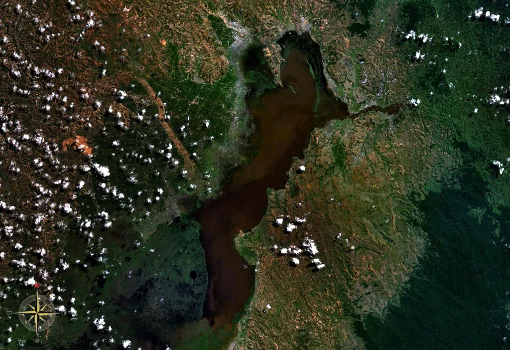
Top-down satellite imagery showing the dark water of Lake Alaotra surrounded by green vegetation and marshland, with scattered white clouds.
Satellite view of Lake Alaotra and surrounding wetlands in Madagascar.

Lake Alaotra history and protected-area timeline

The lake's modern history is fundamentally a story of agricultural intensification colliding with ecological fragility. For generations, the rich alluvial soils around Lake Alaotra have supported rice cultivation, and over time the surrounding hills were cleared to expand the farmed area. As forest cover receded, soil erosion increased dramatically, and sediment began to accumulate in the lake at a pace that has visibly altered its character; the lake's dry-season depth has fallen to roughly 60 centimetres in much of its area.

A major conservation milestone came on February 2, 2003, when Lake Alaotra and its broader catchment were officially recognized as a wetland of international importance under the Ramsar Convention, under the formal title Le Lac Alaotra: Les Zones Humides et Bassins Versants. The listing drew international attention to a site that had already been losing biodiversity for decades, especially its endemic waterbirds. The Alaotra grebe, a small grebe that may have lived only on this lake, was eventually declared extinct in 2010, while the Madagascar pochard, once present here, survives only as a tiny relict population in upland wetlands elsewhere on the island.

In more recent decades, conservation organizations, including the Durrell Wildlife Conservation Trust, have become increasingly active in managing the Alaotra lake protected harmonious landscape, working with local communities to balance rice production, fisheries, and the survival of the basin's endemic wildlife. These efforts reflect a growing recognition that the lake's future depends as much on land-use choices in the surrounding catchment as on the water itself.

Lake Alaotra landscape and geographic character

Lake Alaotra occupies a shallow basin on Madagascar's northern central plateau, at an elevation of roughly 750 metres above sea level. The lake is remarkably flat and shallow, with average depths of only about 0.6 metres and maximum depths around 1.5 metres, making it one of the most gently contoured large water bodies in the region. Its bed has been steadily filling with sediment eroded from the surrounding hills, which were once forested and are now largely cleared for agriculture.

Around the open water lie broad belts of marshland and reedbeds, interspersed with cultivated rice paddies that extend the wet landscape deep into the surrounding plain. The transition from lake to marsh to rice field is gradual, producing a continuous wetland mosaic across a vast area. To the south and west of the lake, the terrain rises into eroded hills and agricultural land, while the wider catchment drains eastward, ultimately sending water toward the Indian Ocean via the Maningory River. The result is a landscape defined by water, soft sediments, and a finely balanced interplay between natural hydrography and human land use.

Lake Alaotra ecosystems, habitats, and plant life

The lake and its catchment support one of Madagascar's most distinctive wetland ecosystems, shaped by altitude, seasonal flooding, and a long history of agricultural modification. Habitats range from open, quiet shallow water through dense floating and emergent vegetation to extensive reedbeds dominated by papyrus-like plants. Beyond these, the basin includes swamps, seasonally inundated grasslands, and large areas of rice paddy that effectively function as additional seasonal wetland habitat for many bird and invertebrate species.

This habitat mosaic creates gradients of inundation, vegetation structure, and water chemistry that sustain a unique flora and fauna. The reedbeds in particular are ecologically critical: they are dense, tall, and structurally complex, providing cover, nesting substrate, and a reliable supply of preferred food plants. Surrounding marsh and paddy habitats buffer the reedbeds against dry-season water loss and disturbance, while the open water provides feeding and dispersal space for fish and waterbirds. Together, these zones form an integrated system whose ecological value far exceeds what any single habitat component would support on its own.

Lake Alaotra wildlife and species highlights

Wildlife is the single most distinctive feature of Lake Alaotra, and the basin is home to several endemic species found nowhere else. The lake's most famous resident is the Alaotra gentle lemur, a small primate subspecies that depends almost entirely on the lake's reedbeds and is considered one of the most range-restricted primates in the world. As reedbeds have been burned to expand rice cultivation, its habitat has shrunk to a small fraction of its former extent, and populations have declined sharply over recent decades.

The lake and its marshes are also a globally important site for waterbirds, including migratory species and several endemics. Historically, the lake supported two endemic waterbirds: the Madagascar pochard, once found on Lake Alaotra but now critically endangered in tiny populations elsewhere, and the Alaotra grebe, which lived primarily on this lake and was declared extinct in 2010. The wetland still hosts other notable waterbirds such as Meller's duck, a threatened species endemic to Madagascar, while the surrounding shallows and marshes host a variety of herons, rails, and other wetland birds. In addition, Lake Alaotra is the type locality of the butterfly Artitropa alaotrana, a species whose name is tied directly to the lake. Fish also play a major ecological role, with introduced species such as the longfin tilapia having established large populations in the lake's open water.

Lake Alaotra conservation status and protection priorities

Lake Alaotra is internationally recognized as a wetland of global significance, formally designated under the Ramsar Convention in 2003 for its outstanding ecological value. The site's conservation importance rests on three pillars: its exceptional concentration of endemic wildlife, its role as a refuge for waterbirds in a heavily modified landscape, and its function as a hydrological regulator for a catchment that underpins Madagascar's most productive rice region.

Despite this recognition, the lake is also one of the country's most threatened wetland systems. Persistent deforestation in the surrounding hills has accelerated soil erosion, leading to heavy sedimentation that is rapidly reducing the lake's depth and ecological complexity. Reedbed burning has destroyed large areas of habitat critical to the Alaotra gentle lemur, and multiple endemic bird populations have collapsed or disappeared locally. Conservation responses have increasingly emphasized integrated landscape management; organizations such as the Durrell Wildlife Conservation Trust work within the Alaotra lake protected harmonious landscape alongside local communities to balance fisheries, rice cultivation, and the survival of endemic species. The lake's future now depends on sustaining these partnerships and on reducing the upstream pressures that continue to erode the basin's natural infrastructure.

Lake Alaotra cultural meaning and human context

Lake Alaotra sits at the heart of Madagascar's most important rice-producing region, and rice cultivation has shaped the cultural and economic life of surrounding communities for generations. The lake's fertile plains and predictable seasonal flooding have supported dense rural populations whose livelihoods depend on paddy agriculture and, increasingly, on lake fisheries.

Traditional land use in the surrounding hills has historically included forest resource extraction, slash-and-burn agriculture, and grazing, practices that have gradually transformed the catchment over the past century. The relationship between local communities and the lake's reedbeds is particularly significant; reed cutting and burning have been used both for subsistence and to expand rice land, a practice now recognized as a major driver of biodiversity loss for species such as the Alaotra gentle lemur. This places the lake at a cultural crossroads, where artisanal knowledge of rice and wetland management is being integrated, often in new ways, with modern conservation frameworks.

Top sights and standout views in Lake Alaotra

Lake Alaotra stands out globally as Madagascar's largest freshwater lake, its most important rice-producing basin, and one of the island's most ecologically urgent Ramsar wetlands. Its reedbeds harbor the only known wild populations of the Alaotra gentle lemur, while its waters once supported endemic waterbirds now lost from the site, including the extinct Alaotra grebe.

The lake's combination of large wetland extent, exceptional endemism, and intense human pressure makes it a textbook example of the challenges facing tropical wetlands in the twenty-first century. International recognition through the Ramsar Convention and active management by organizations such as the Durrell Wildlife Conservation Trust reflect growing efforts to protect both the wetland's biodiversity and the agricultural system that depends on its water.

Best time to visit Lake Alaotra

Lake Alaotra lies in Madagascar's tropical highland zone, where seasonal contrasts are primarily defined by the wet and dry seasons rather than by temperature. The broader region is generally more accessible during the drier months, when flooded plains and rice paddies recede and roads across the surrounding farmland are more reliable than during the height of the rains.

The wet season transforms the landscape into a vast, green wetland mosaic, with peak water levels in open water, reedbeds, and rice paddies. For wildlife observation, the reedbed and paddy edges are usually most active around the transitions between wet and dry periods, when water levels are changing and bird activity is high. Because agricultural patterns and ecological conditions vary year to year, any visit is best planned with attention to both climatic conditions and the seasonal rhythms of local rice cultivation.
Monthly climate preview

Long-term representative monthly averages for temperature and precipitation

Lake Alaotra Climate Normals and Annual Temperature Rhythm

Representative coordinate records show measured monthly temperature and precipitation rhythms across the protected landscape. Examining the full twelve-month profile provides complete historical averages for detailed geographic comparison.
Annual mean19 °C
16 °C22 °C
Jan22°
Feb22°
Mar22°
Apr20°
May19°
Jun17°
Jul16°
Aug16°
Sep17°
Oct19°
Nov21°
Dec22°
Warmest month
January

22.1 °C

Coolest month
July

15.8 °C

Wettest month
February

12 mm/day

Driest month
September

1.5 mm/day

Park location guide

Geography guide, regional context, and park location map for Lake Alaotra

Lake Alaotra park geography, regions, and map view in Madagascar

Understand where Lake Alaotra sits in Madagascar through a broader geographic reading of the surrounding landscape, nearby location context, and its mapped position within the national park landscape.

How Lake Alaotra fits into Madagascar

Madagascar is an island nation in the Indian Ocean, positioned off the southeastern coast of Africa. As the world's fourth-largest island and second-largest island country, it stands out for its exceptional biodiversity, over 90% of its wildlife is endemic, making it one of 17 megadiverse countries. The population is approximately 32 million, with Antananarivo as both the capital and largest city.

Wider geography shaping Lake Alaotra in Madagascar

Madagascar lies in the Indian Ocean off the southeastern coast of Africa, separated from the mainland by the Mozambique Channel. The island is situated approximately 400 km from the African continent. As the world's fourth-largest island, it also includes numerous smaller peripheral islands.

Map view of Lake Alaotra

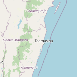
Use this park location map to pinpoint Lake Alaotra in Madagascar, understand its exact geographic position, and read its mapped placement within the surrounding landscape more clearly.

Pigeon | © OpenStreetMap contributors

Location context for Lake Alaotra

Alaotra-Mangoro

Explore protected area photography, marshland habitats, and the unique terrain of Madagascar's largest lake.

Lake Alaotra Photos and Landscape Scenery: Visualizing Madagascar's Premier Wetland

Visual records reveal the expansive shallow waters, dense reedbeds, and agricultural mosaic defining the Lake Alaotra basin. Examining protected area photography helps researchers and travelers interpret the delicate balance between fragile endemic wildlife habitats and surrounding human land use.

Top-down satellite imagery showing the dark water of Lake Alaotra surrounded by green vegetation and marshland, with scattered white clouds.

Park atlas

Compare regional wetland habitats and surrounding conservation areas

Explore Parks Near Lake Alaotra and Connected Protected Landscapes

Browse other protected areas near Lake Alaotra to examine regional wetland systems and highland conservation landscapes. Comparing adjacent geography provides deeper context for Madagascar freshwater reserves and valley habitats.
Nature reserveAlaotra-Mangoro
About 35 km away#1 closest

Southeast

Ankeniheny-Zahamena Corridor: Nature Reserve Landscape and Regional Geography

Mapping the central rainforest belt of the Alaotra-Mangoro region

Spanning over 3,800 square kilometers, the Ankeniheny-Zahamena Corridor stands as a cornerstone of Malagasy conservation. This reserve integrates diverse humid forest habitats into a single functioning landscape, providing a critical haven for endemic flora and threatened primates. Its role as a major watershed catchment reinforces its environmental importance for surrounding communities across eastern and western Madagascar.

Area
3,810 km²
Established
2007
IUCN
VI
Relief
Mixed relief
National parkMadagascar
About 41 km away#2 closest

Southeast

Zahamena National Park: Madagascar National Park Exploration and Geographic Context

Mapping the protected boundaries and landscape of Zahamena National Park.

Delve into Zahamena National Park, a vital protected territory situated in Madagascar. This national park offers a unique perspective on the island's natural geography and its status as a significant protected landscape. Understand its position within Madagascar's broader context, focusing on the mapped aspects of its protected area identity and its contribution to the country's renowned biodiversity hotspot status.

Area
423 km²
Established
1997
IUCN
II
Relief
Mountain
Nature reserveAnalanjirofo
About 88 km away#3 closest

Southeast

Réserve naturelle intégrale de Betampona: Atlas and Geographic Protected Area Profile

A vital lowland humid forest enclave in Analanjirofo

Delve into the mapped terrain of Réserve naturelle intégrale de Betampona, an integral nature reserve established in 1927 that protects a critical lowland humid evergreen forest fragment. The landscape is defined by its steep ridges and rapid stream networks, providing essential refuge for endemic lemurs and diverse plant life. This profile offers a clear view of the reserve's geographic setting and its status as a key conservation anchor for the eastern coastal ecosystems of Madagascar.

Area
29.18 km²
Established
1927
IUCN
Ia
Relief
Mountain
Wildlife reserveAtsinanana
About 89 km away#4 closest

Southeast

Réserve spéciale de Mangerivola: Geographic Overview of an Atsinanana Wildlife Reserve

Rainforest topography and protected corridor mapping

Réserve spéciale de Mangerivola serves as a cornerstone of the eastern Malagasy rainforest corridor. This overview provides insight into the reserve's challenging, roadless terrain and its layered ecological composition, ranging from dense humid forests to rocky, high-altitude outcrops that sustain rare bird species and seven distinct lemur populations.

Area
130.05 km²
Established
1958
IUCN
IV
Relief
Upland
Wildlife reserveSofia region
About 139 km away#5 closest

North

Tampoketsa Analamaitso Reserve: Wildlife Reserve and Protected Forest Geography in Sofia Region

Ecological transition zone featuring humid and dry forest biomes

Tampoketsa Analamaitso Reserve provides a protected sanctuary for northern Madagascar's primate fauna, defined by its rare combination of humid mid-altitude and dense dry forest ecosystems. Managed for habitat conservation, the reserve remains a remote wilderness area with intact forest cover that stretches across the Sofia region. Its geographic importance lies in the ecological gradient that links distinct upland and lowland vegetation types, offering a comprehensive look at the island's diverse natural terrain.

Area
171.5 km²
Established
1958
IUCN
IV
Relief
Upland
Watercolor illustration of a landscape featuring mountains, a lake, trees, and pink flowers in the foreground
National parkAlaotra-Mangoro
About 159 km away#6 closest

South

Analamazaotra National Park: Protected Rainforest Ecosystem and Mapped Landscape in Alaotra-Mangoro

Explore Madagascar's Eastern Highlands protected area geography.

Analamazaotra National Park, situated in Madagascar's Alaotra-Mangoro region, represents a critical segment of the island's protected eastern rainforests. This national park is mapped as a vital conservation area, offering insights into its unique ecosystems and natural terrain. Understanding Analamazaotra National Park's geographic placement and protected boundaries provides essential context for regional landscape exploration and atlas-based geographic discovery within Madagascar.

Area
26.53 km²
Established
2015
IUCN
II
Relief
Highland
National parkAlaotra-Mangoro
About 159 km away#7 closest

South

Andasibe-Mantadia National Park: National Park and Protected Landscape Identity

Explore its mapped boundaries and geographic context.

Andasibe-Mantadia National Park is a distinct protected territory within the Alaotra-Mangoro region, serving as a crucial focal point for understanding Madagascar's regional geography and protected land distribution. This detail page provides essential atlas-style information on the park's mapped area and its natural landscape characteristics. Engage with structured data that highlights the park's protected status and its position within the broader geographic framework of eastern Madagascar, supporting focused discovery for researchers and explorers.

Area
155 km²
Established
1989
IUCN
II
Visitors
26.1K annual
National parkMadagascar
About 159 km away#8 closest

South

Mantadia National Park: Madagascar National Park and Protected Landscape Atlas

Mapped boundaries and regional geographic context of Mantadia.

Mantadia National Park represents a crucial protected landscape within Madagascar, detailed here for comprehensive geographic and atlas exploration. This entry focuses on its identity as a national park, providing insights into its mapped boundaries and its contribution to the understanding of Madagascar's diverse natural terrain. The information facilitates a structured discovery of the park's environmental and geographical significance, essential for anyone mapping protected areas.

Common questions about visiting, size, designation, and location context for Lake Alaotra

Lake Alaotra FAQs for park facts, access, geography, and protected area context

Find quick answers about Lake Alaotra, including protected-area facts, park geography, trail and visitor context, and how the park fits into its surrounding country and regional landscape.
MoriAtlas Explorer

Continue Your Protected Areas Search Across the Global Atlas

Deepen your exploration by continuing the structured search for national parks and protected areas worldwide. Utilize the comprehensive filtering capabilities to compare different conservation landscapes and refine your understanding of global park geography. Discover more about the distribution and characteristics of protected natural areas.

Global natural geography