
Mori Atlas logo
Protected areaLake Pátzcuaro

Discover the geographic boundaries, wetland systems, and volcanic terrain of this central Mexican basin

Lake Pátzcuaro Protected Area: Mapping the Volcanic Basin and Highland Landscape of Michoacán

Lake Pátzcuaro serves as a significant high elevation protected landscape within a volcanic basin in the state of Michoacán, Mexico. The basin features an endorheic lake system surrounded by steep mountain ridges, extensive cattail wetlands, and diverse pine-oak forest ecosystems. This atlas entry details the natural geography of the region, emphasizing its unique terrain, protected wetland status, and the physical characteristics that define this iconic highland environment.

highland lakeendorheic basinvolcanic landscapeRamsar wetlandfreshwater lakePurépecha heritage

Lake Pátzcuaro

Protected area

Park overview

Structured park overview, official facts, and landscape profile for Lake Pátzcuaro

Lake Pátzcuaro park facts, protected area profile, and essential visitor context

Review the core facts for Lake Pátzcuaro, including designation, size, terrain, visitor scale, habitats, and operating context in one park-focused overview.

About Lake Pátzcuaro

Lake Pátzcuaro is one of Mexico's most iconic inland water bodies, a freshwater lake nestled high in the volcanic highlands of Michoacán. Set within an endorheic basin that does not drain to the sea, the lake occupies a roughly oval depression surrounded by steep volcanic slopes that rise into the Trans-Mexican Volcanic Belt. Today it stretches across approximately 126 square kilometres, sits more than 2,000 metres above sea level, and is unusually shallow, with an average depth of around five metres and rare maximum depths approaching twelve metres. Because of this shallowness, broad, marshy wetland fringes have developed along much of the shoreline.

Far more than a scenic landscape, the lake is a powerful symbol of indigenous Mexican identity. For centuries it has functioned as the heart of Purépecha (Tarascan) culture, and major Purépecha settlements including Pátzcuaro, Tzintzuntzan, and Ihuatzio were founded along its shores. The lake carries layers of pre-Hispanic, colonial, and living indigenous heritage, from ancient yácatas ruins to vibrant traditional crafts, regional cuisine, and one of the country's most recognized cultural events: the Día de Muertos celebrations centered on the island of Janitzio.

Ecologically, Lake Pátzcuaro is just as significant as it is culturally. Its marshes were designated a Ramsar wetland of international importance in 2005, recognizing their value as habitat for waterbirds and as a refuge for endemic aquatic species. The lake harbors an unusual concentration of fauna found nowhere else, including the Lake Pátzcuaro salamander, the Pátzcuaro chub, the Pátzcuaro allotoca, the rough-footed mud turtle, and the Pátzcuaro dwarf crayfish, alongside nearly 200 recorded bird species. Surrounding the lake, pine-oak forests and xeric scrub climb the slopes, forming part of the broader Trans-Mexican Volcanic Belt pine-oak forest ecoregion.

Yet Lake Pátzcuaro is also a study in environmental vulnerability. Over the past half-century, deforestation, agricultural expansion, water diversion, untreated sewage, sedimentation, and invasive species have stressed the system, contributing to measurable drops in lake level, reduced depth, water quality decline, and localized extinctions. Restoration efforts led by government, scientists, and indigenous organizations are attempting to reverse these trends while preserving both the natural and cultural value of the basin.

Quick facts and research context for Lake Pátzcuaro

Lake Pátzcuaro is a high-altitude endorheic lake in Michoacán, Mexico, sitting within a volcanic basin flanked by steep mountains. The catchment covers roughly 929 square kilometres, with the water body itself spanning about 126 square kilometres at an elevation of more than 2,000 metres. Although shallow, with an average depth of around five metres, the lake and its surrounding wetlands were designated a Ramsar site of international importance in 2005.

The lake is the historic center of the Purépecha civilization and home to several iconic Mexican cultural traditions, most notably the Día de Muertos celebrations on Janitzio. Ecologically, the system is notable for endemic species such as the Lake Pátzcuaro salamander, the Pátzcuaro chub, and the Pátzcuaro dwarf crayfish, alongside rich waterbird diversity around the marshlands.

Protection and recognition

Explore recorded terrestrial designation timelines and management scope details.

Lake Pátzcuaro Protection Status and Documented Conservation History

Lake Pátzcuaro maintains a documented terrestrial protection status established in 2005. Recorded designation history and management scope provide clear administrative context for conservation tracking.

Protection details

Protection scope
Terrestrial
Designated year
2005
Transboundary protection
No
Park context

Deeper park guide and search-rich context for Lake Pátzcuaro

Lake Pátzcuaro history, landscape, wildlife, and travel context

Explore Lake Pátzcuaro through its history, landscape character, ecosystems, wildlife, conservation priorities, cultural context, and seasonal travel timing in a structured park guide built for atlas discovery and search intent.

Why Lake Pátzcuaro stands out

Lake Pátzcuaro is best known as the cultural and ecological heartland of the Purépecha people, a highland basin of volcanic origin surrounded by dramatic mountain scenery. Its islands, particularly Janitzio, are famous worldwide for the Día de Muertos ceremonies that draw visitors each November, when candlelit cemeteries and decorated graves honor the deceased in a deeply indigenous tradition. Ecologically, the lake is recognized for its Ramsar-listed wetlands, extensive cattail marshes, and high biodiversity. It is also notable as the only natural habitat of the iconic Lake Pátzcuaro salamander (ajolote) and several endemic fish and crayfish, making it both a cultural landmark and a conservation site of distinct Mexican natural heritage.
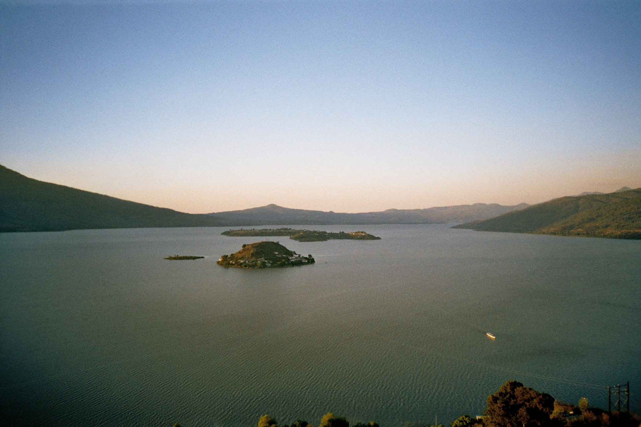
Islands of Lake Patzcuaro from Janitzio Island
A view of islands in Lake Patzcuaro, photographed from the top of Janitzio island in Michoacan, Mexico.

Lake Pátzcuaro history and protected-area timeline

The history of Lake Pátzcuaro stretches back tens of thousands of years. Scientific studies based on sediment cores indicate that roughly 38,000 to 25,000 years ago the lake was once part of an open hydrological system that connected it to the Lerma River through neighboring basins such as Lakes Cuitzeo and Zirahuén. During colder periods of the late Pleistocene, the lake was significantly deeper than today. Over time, tectonic and climatic shifts closed the basin, transforming it into the endorheic system it is now.

For at least 4,000 years, the lake has supported human life. It became the cultural and political heart of the Purépecha people (also known as the Tarascan people), whose leaders established the nearby city of Tzintzuntzan as the capital of the Tarascan state. This powerful indigenous polity rivaled the Aztec Empire and maintained a distinct cultural and linguistic identity until the Spanish conquest in the early sixteenth century. The towns of Pátzcuaro, Tzintzuntzan, and Ihuatzio emerged as major Purépecha centers, and their spiritual and political importance remained tied to the lake long after colonization.

In the modern era, the lake has been the focus of sustained scientific and governmental attention. The Estación Limnológica de Pátzcuaro, established in 1938, marked one of Mexico's earliest organized efforts to study a lake ecosystem. Since the mid-twentieth century, however, industrial-scale deforestation, agricultural expansion, urban growth, and water diversion have placed enormous pressure on the basin. By the early twenty-first century, these pressures had reduced the lake's surface area and depth dramatically, prompting Ramsar recognition in 2005 and a series of restoration programs that continue today.

Lake Pátzcuaro landscape and geographic character

Lake Pátzcuaro lies at the bottom of a dramatic volcanic basin, with the lake surface sitting roughly 2,000 metres above sea level and the surrounding peaks climbing toward 2,900 metres. The terrain is the product of long volcanic activity associated with the Trans-Mexican Volcanic Belt, and the result is a bowl-like landscape of steep ridges, deep ravines, and rolling highland plateaus that frame the water body. Because the lake is unusually shallow and the basin has no outflow, broad, shallow fringes have developed into extensive wetlands where aquatic vegetation, particularly cattails, can form dense stands more than two metres tall.

On the slopes above the lake, vegetation changes dramatically with elevation. Lower elevations are dominated by xeric scrub adapted to drier highland conditions, while the middle range blends pine and oak woodland with thorny scrub. The highest peaks support purer pine-oak forests, part of the larger Trans-Mexican Volcanic Belt pine-oak forest ecoregion. This stratified vegetation pattern gives the lake's surroundings an unusually rich visual texture: green pine forests above, dry scrub in the middle, marsh below, and the broad water surface at the center.

Volcanic islands break up the lake's surface and add to its distinctive silhouette. Several of these islands, including Janitzio, Pacanda, Yunuen, and Tecuena, rise from the shallow water as small landforms that have historically been inhabited and connected to the lake's cultural life. Together, the combination of steep mountains, calm highland water, and sentinel islands gives Lake Pátzcuaro one of the most recognizable and photogenic landscapes in central Mexico.
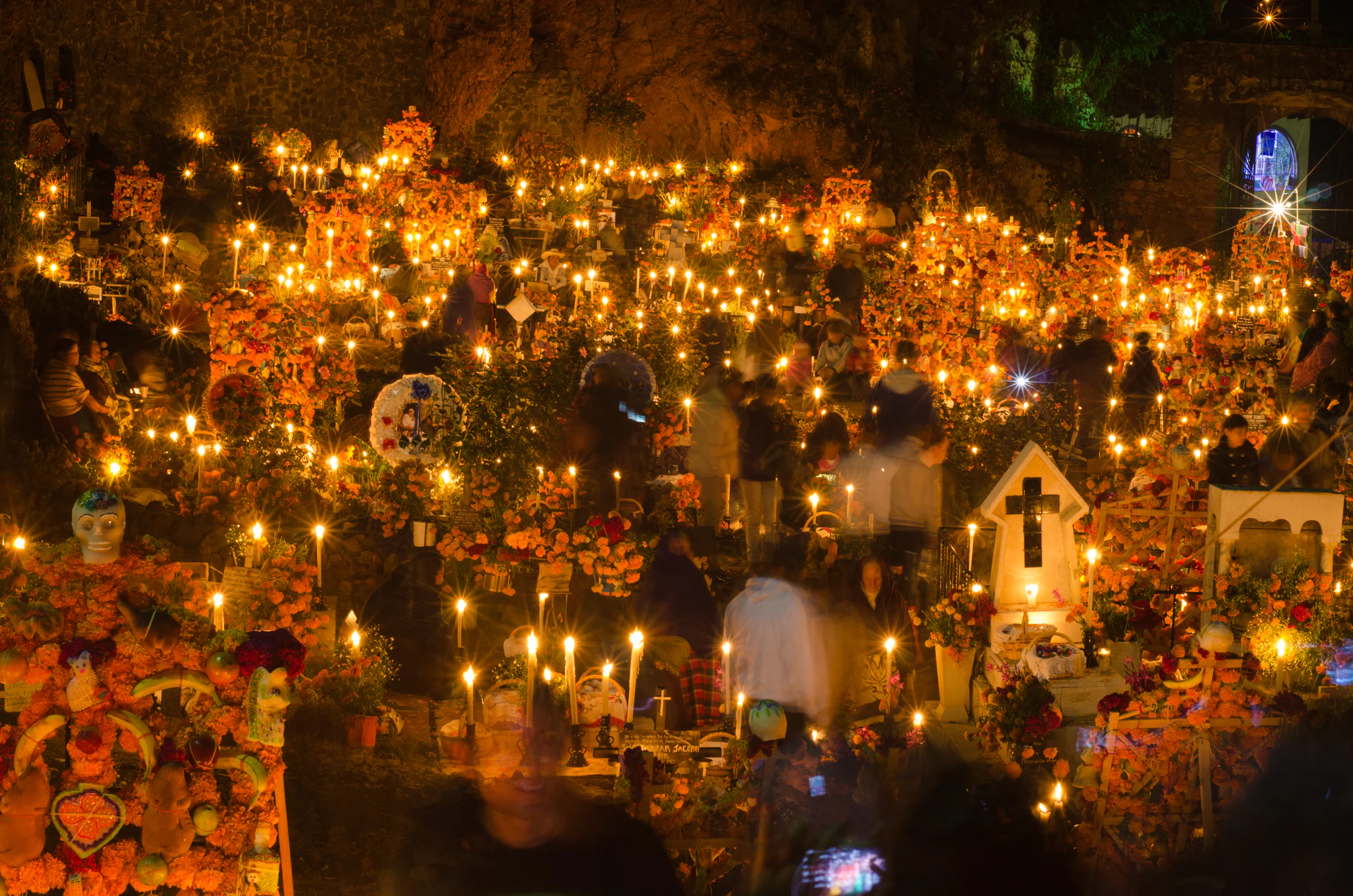
Day of the Dead celebration on Janitzio Island
A traditional Noche de Animas ceremony held on November 2nd at Janitzio Island, Lake Patzcuaro, featuring symbolic offerings to honor the deceased.

Lake Pátzcuaro ecosystems, habitats, and plant life

The ecological identity of Lake Pátzcuaro is defined by the interaction of its shallow high-elevation water, extensive cattail-dominated wetlands, and surrounding volcanic forests. Because the lake is so shallow, much of its shore transitions gradually into marshy habitat rather than rocky or sandy coastline. This produces broad belts of emergent aquatic vegetation, dominated by cattails and other reeds, that provide essential cover for fish, amphibians, and waterbirds.

The lake is unusually rich in plant species for a Mexican aquatic system, with dozens of recorded aquatic and wetland species across a wide range of plant families. Common aquatic vegetation includes pondweeds, water lilies, and dense stands of cattails and sedges. The transition from wetland to upland is marked by a clear vegetation gradient: xeric scrub at the lower elevations gives way to mixed pine-oak forest, which in turn yields to purer pine-oak woodland at the highest reaches of the basin. This gradient is part of the broader Trans-Mexican Volcanic Belt pine-oak forests ecoregion, recognized for its ecological importance.

In the waters themselves, the lake's endorheic character and long isolation have created the conditions for a remarkable set of endemic species. Lake Pátzcuaro is the only home of the Lake Pátzcuaro salamander (ajolote de Pátzcuaro), the Pátzcuaro chub, the Pátzcuaro allotoca, and the Pátzcuaro dwarf crayfish, along with subspecies of mud turtle and garter snake found nowhere else. These species have evolved in the absence of an outlet to the sea and are highly vulnerable to changes in water quality, sediment load, and introduced competitors.
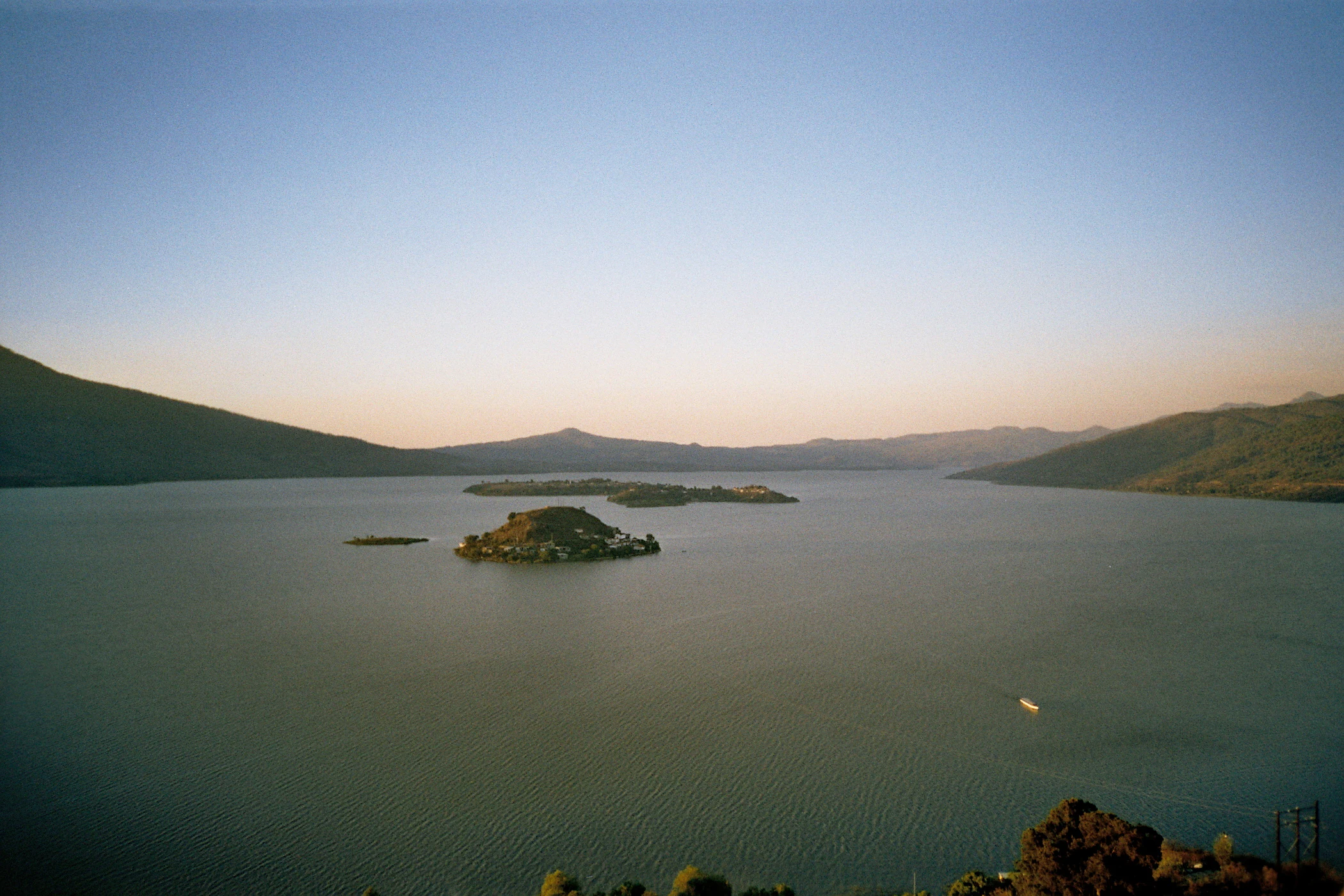
View of islands from Janitzio Island
Islands in Lake Pátzcuaro as seen from the top of Janitzio Island in Michoacan, Mexico.

Lake Pátzcuaro wildlife and species highlights

Wildlife is one of Lake Pátzcuaro's defining natural features, both in the water and on the wing. The lake and surrounding wetlands host close to 200 bird species, including year-round residents and migratory waterfowl that use the marshlands as seasonal habitat. The cattail-dominated wetlands provide nesting cover and feeding grounds for a wide variety of herons, ducks, rails, and songbirds, while the surrounding forests support additional birdlife and small to medium-sized mammals such as opossums, squirrels, rabbits, foxes, skunks, and badgers.

The lake's aquatic fauna is particularly notable for its endemism. The Lake Pátzcuaro salamander (Ambystoma dumerilii), known locally as the ajolote, is an iconic Mexican species found only in this basin and now considered threatened. Several fish species are likewise restricted to these waters, including the Pátzcuaro chub and the Pátzcuaro allotoca, alongside the endangered whitefish (pez blanco) and the Pátzcuaro dwarf crayfish, which has also become popular in aquarium circles and serves as an important host species for a range of microscopic aquatic organisms in the lake. Subspecies of mud turtle and Mexican garter snake are similarly unique to the system.

The lake's wildlife has not been immune to recent changes. Once-common species such as the yellow rail have not been observed in decades, and the slender-billed grackle, an endemic bird that lived in the lake's marshes, is now presumed extinct. Introduced species such as largemouth bass, tilapia, and carp have also altered native fish populations. These shifts make Lake Pátzcuaro both a remarkable place for observing wildlife and a sobering example of how human pressures can reshape a closed aquatic ecosystem.
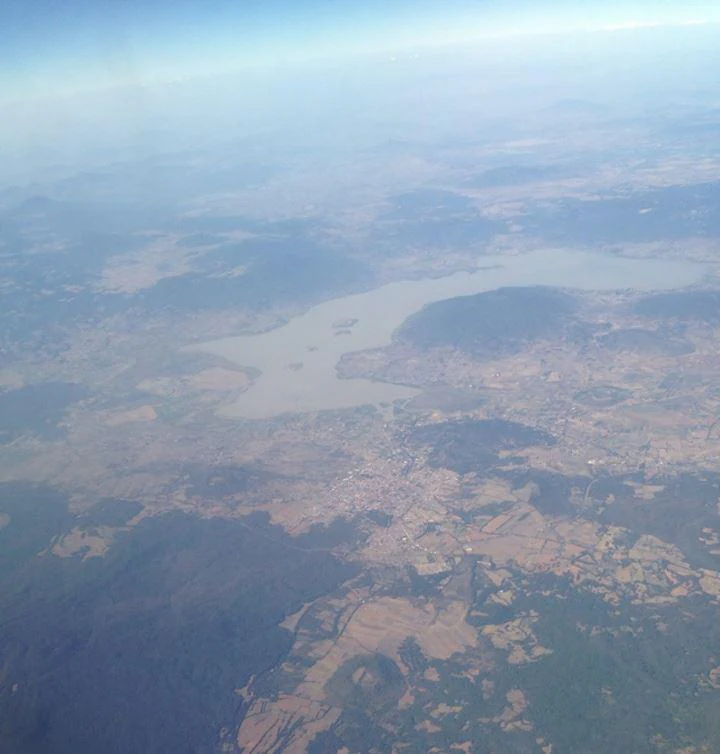
Lake Patzcuaro aerial view
Aerial view of Lake Patzcuaro

Lake Pátzcuaro conservation status and protection priorities

Lake Pátzcuaro is recognized for its conservation importance at both national and international levels. Its wetlands were designated a Ramsar site in February 2005, formally acknowledging their value as habitat for migratory waterfowl and as a refuge for endemic aquatic species. The Ramsar listing has helped focus international attention on the lake's ecological state and on the urgent need to address long-running pressures such as deforestation, watershed degradation, water extraction, untreated sewage, and pollution.

The basin faces a complex set of conservation challenges that touch on water, soil, biodiversity, and human wellbeing. Logging, fuelwood harvesting, agricultural clearing, and livestock expansion have led to the loss of more than 10,000 hectares of forest in the watershed. This deforestation has contributed to heavy sedimentation of the lake and to water quality decline, along with the introduction of aggressive non-native species. Local indigenous organizations, including the Supreme Indigenous Council of Michoacán, have also highlighted how decades of inconsistent policy, corruption, and lack of cross-agency coordination have undermined restoration efforts.

In response, state and regional authorities have launched reforestation campaigns, including drone-assisted planting of millions of trees, alongside limnological research through institutions such as the Pátzcuaro Limnological Station. The conservation stakes are high not just for biodiversity but for the cultural identity and livelihoods of the surrounding communities. Protecting Lake Pátzcuaro therefore means safeguarding a wetlands ecosystem, an iconic set of endemic species, and a centuries-old cultural landscape all at once.

Lake Pátzcuaro cultural meaning and human context

Lake Pátzcuaro is inseparable from Purépecha (Tarascan) identity. The basin was the political and spiritual core of the Tarascan state, whose leaders built their capital at Tzintzuntzan along the lake's shore. Even after the Spanish conquest, the lake remained a cultural anchor for indigenous communities, with towns such as Pátzcuaro, Erongarícuaro, Ihuatzio, Quiroga, and Tzintzuntzan preserving strong Purépecha heritage alongside colonial-era architecture.

The cultural landscape of the lake includes traditional crafts such as mask making, woodworking (notably in Tocuaro), lacemaking, ceramics, and regional cuisine. The lake's islands also carry deep cultural meaning. Janitzio in particular is famous for its Día de Muertos observances, when candlelit boats, cemetery processions, and marigold-flower displays transform the island into one of Mexico's most emblematic settings for honoring the deceased. The Día de Muertos festivities at Janitzio and Tzintzuntzan have become an international symbol of Mexican living traditions.

Equally important is the recognition that the lake's cultural identity is rooted in long-standing indigenous stewardship. Recent commentary from Purépecha organizations has emphasized that the lake is not merely a heritage site but a living territory tied to community identity, food systems, and traditional knowledge. This context shapes contemporary debates over conservation, governance, and how best to restore both the lake's ecological health and the cultural livelihoods that depend on it.

Top sights and standout views in Lake Pátzcuaro

Lake Pátzcuaro's standout qualities are its combination of volcanic highland scenery, exceptionally rich wetland ecosystems, and deep indigenous cultural roots. The lake is one of Mexico's most important Ramsar wetlands, recognized for its cattail marshlands and nearly 200 recorded bird species, and it is the only natural habitat of the renowned Lake Pátzcuaro salamander and a remarkable set of endemic fish and crayfish.

Its cultural highlights are equally distinctive. The lake is the cradle of Purépecha civilization and the setting for some of Mexico's most iconic Día de Muertos celebrations on Janitzio and Tzintzuntzan. Together, these ecological and cultural dimensions make Lake Pátzcuaro a uniquely layered place, where pre-Hispanic heritage, living indigenous traditions, and one of Mexico's more ecologically distinctive wetlands meet in a single highland basin.

Best time to visit Lake Pátzcuaro

The climate around Lake Pátzcuaro is subhumid with a clear seasonal rhythm: a pronounced rainy season lasting roughly five to six months and a drier, cooler period the rest of the year. Average air temperatures in the basin's influence zone range from the low teens in cooler months to the high teens Celsius, and the lake water remains relatively cool year round, generally staying between roughly 15 and 22 degrees Celsius in measured periods.

For those interested in natural scenery, the rainy season brings lusher vegetation around the lake and forests, while the dry months offer clearer views across the water and mountains. For cultural visits, early November is the most iconic period, leading into the Día de Muertos celebrations on November 1 and 2, when local communities honor the deceased with marigolds, candles, and cemetery vigils, particularly on Janitzio and around Tzintzuntzan. Birding visitors will find waterbird activity strongest when migratory species are present, while general exploration is pleasant in either the cool dry season or the greener wet season, depending on whether wetland thriving or panoramic clarity is the priority.

Park guides

Essential planning insights for the volcanic basin and wetlands

Lake Pátzcuaro Published Guides and Focused Research Answers

Selected readings provide focused answers to key questions about regional planning and seasonal timing at Lake Pátzcuaro. Publications examine optimal visitation periods by balancing dry winter conditions against cultural events in November.
Monthly climate preview

Long-term representative temperature ranges and precipitation rhythm across twelve months

Lake Pátzcuaro Climate Normals and Measured Monthly Weather Patterns

Representative coordinates record measured monthly temperature swings and precipitation averages from 1991 to 2020 at an elevation of 1787 meters. Examining the complete twelve-month profile reveals detailed baseline normals for long-term climatic analysis.
Annual mean19 °C
15 °C22 °C
Jan15°
Feb17°
Mar19°
Apr21°
May22°
Jun21°
Jul19°
Aug19°
Sep19°
Oct18°
Nov17°
Dec16°
Warmest month
May

22 °C

Coolest month
January

15.5 °C

Wettest month
July

5.2 mm/day

Driest month
April

0.1 mm/day

Park location guide

Geography guide, regional context, and park location map for Lake Pátzcuaro

Lake Pátzcuaro park geography, regions, and map view in Mexico

Understand where Lake Pátzcuaro sits in Mexico through a broader geographic reading of the surrounding landscape, nearby location context, and its mapped position within the national park landscape.

How Lake Pátzcuaro fits into Mexico

Mexico, officially the United Mexican States, is a country in North America spanning the Sierra Madre mountain ranges, coastal plains, and tropical regions. It borders the United States to the north, Guatemala and Belize to the southeast, and has coastlines along the Pacific Ocean, Gulf of Mexico, and Caribbean Sea. With a population exceeding 130 million, Mexico is home to one of the world's most significant concentrations of Indigenous languages alongside Spanish.

Wider geography shaping Lake Pátzcuaro in Mexico

Mexico occupies a land area of 1,972,550 km2, making it the thirteenth-largest country in the world. The terrain is highly diverse, featuring the Sierra Madre Occidental and Sierra Madre Oriental mountain ranges, the Mexican Plateau, coastal lowlands along the Pacific and Gulf/Caribbean margins, and the Yucatan Peninsula. The country spans multiple climate zones from desert in the north to tropical rainforest in the south.

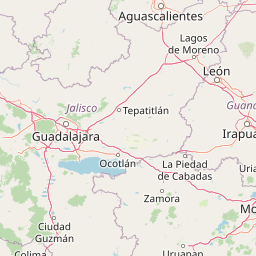
Map view of Lake Pátzcuaro

Use this park location map to pinpoint Lake Pátzcuaro in Mexico, understand its exact geographic position, and read its mapped placement within the surrounding landscape more clearly.

Pigeon | © OpenStreetMap contributors

Location context for Lake Pátzcuaro

Michoacán

Visual reference for highland terrain, Ramsar wetlands, and protected basin habitats

Lake Pátzcuaro Photos and Volcanic Landscape Scenery

Visual documentation reveals the dramatic volcanic topography and wetland habitats that define Lake Pátzcuaro. Detailed photography captures the stratified mountain slopes, island silhouettes, and protected ecosystems of the highland basin.

Islands of Lake Patzcuaro from Janitzio Island

Fishermen at Lake Patzcuaro

Day of the Dead celebration on Janitzio Island

View of islands from Janitzio Island

Lake Patzcuaro aerial view

Park atlas

Compare regional protected landscapes, highland terrain, and connected wetland habitats across central Mexico.

Explore Parks Near Lake Pátzcuaro and Surrounding Volcanic Protected Areas

Browse nearby national parks and protected areas sharing the volcanic geography and high-elevation terrain of Lake Pátzcuaro. Extending the geographic comparison reveals broader ecological patterns and conservation contexts across the surrounding region.
Protected areaMichoacán
About 27 km away#1 closest

Northwest

Zacapu Lagoon Protected Area: Mapping the Highland Wetlands of Central Michoacán, Mexico

An endemic-rich spring-fed wetland within the Lerma River basin system

Located in the state of Michoacán, Zacapu Lagoon serves as a vital protected area and perennial wetland. This highland site is defined by its spring-fed waters and riparian vegetation, providing a crucial refuge for narrow-range endemic fish and amphibian species. The lagoon functions as a benchmark for understanding aquatic biodiversity within the complex hydrological network of the Mexican highlands.

Area
0.216 km²
Established
2003
Relief
Lowland
Scope
Terrestrial
Protected areaMichoacán
About 35 km away#2 closest

North

Alberca de los Espinos: Volcanic Crater and Protected Wetland Geography in Michoacán

Highland crater lake within the Trans-Mexican Volcanic Belt

The protected basin of Alberca de los Espinos forms a striking volcanic landform. Deep within its 2,100-meter crater rim, the lake exhibits complex thermal stratification and seasonal color changes. This site serves as a vital component of the regional geography in Michoacán, blending geological character with recognized wetland status.

Area
1.42 km²
Established
2003
Relief
Upland
Climate
Temperate
National parkMichoacán
About 51 km away#3 closest

Southwest

Barranca del Cupatitzio National Park: National Park, Michoacán Protected Area

Mapped boundaries and regional geographic context.

Barranca del Cupatitzio National Park stands as a designated national park, providing critical geographic information for atlas exploration. Understand its specific mapped protected area boundaries and discover its role within the regional geography of Michoacán. This profile highlights the park's landscape identity and its significance as a key protected natural site for detailed geographic study.

Area
4.582 km²
Established
1938
IUCN
II
Visitors
255.2K annual
National parkMichoacán
About 67 km away#4 closest

Northwest

Lago de Camécuaro National Park: National Park Protected Landscape and Geographic Atlas

Mapped boundaries and regional natural landscape context for Michoacán.

Lago de Camécuaro National Park offers a focused exploration of a distinct protected area within Michoacán, Mexico. Understand its specific geographic identity through mapped boundaries and regional terrain context, suitable for atlas-based discovery of natural landscapes and conservation areas. This entry provides a factual overview of the park's protected status and its placement within the broader geography of the region.

Area
0.097 km²
Established
1941
IUCN
II
Relief
Upland
Wildlife reserveMichoacán
About 73 km away#5 closest

West

Área de protección de flora y fauna Pico de Tancítaro: Geographic and Landscape Overview

Protected volcanic highlands in the state of Michoacán

Trace the ridges and forested valleys of this federal wildlife reserve. The area integrates sustainable land use with the protection of native highland ecosystems, marking a core point of interest for those tracking the volcanic geography of Mexico's Trans-Mexican Volcanic Belt.

Area
234.06 km²
Established
2009
Relief
Mountain
Scope
Terrestrial
National parkMichoacán
About 84 km away#6 closest

East

Cerro de Garnica National Park: Its Geography and Protected Landscape Identity

Explore mapped boundaries within Michoacán's natural terrain.

Cerro de Garnica National Park serves as a distinct protected area contributing to the geographic understanding of Michoacán. This page offers a focused view on its mapped boundaries and natural landscape characteristics, providing essential context for atlas exploration. Discover the park's specific identity as a national park and its place within the regional geography, highlighting its value for structured discovery.

Area
19.36 km²
Established
1936
IUCN
II
Relief
Mountain
Protected areaGuanajuato
About 87 km away#7 closest

Northeast

Lake Yuriria: Exploring the Protected Landscape and Volcanic Terrain of Guanajuato

A historic artificial wetland and Ramsar-recognized migratory bird habitat.

Lake Yuriria serves as a benchmark for landscape conservation in the Bajio region. Spanning an extensive wetland area within a volcanic basin, this protected zone provides essential habitat for over 140 bird species and remains a cornerstone of the regional geography for its water regulation and agricultural impact.

Area
72 km²
Established
1548
Relief
Lowland
Climate
Subtropical
Natural monumentGuanajuato
About 98 km away#8 closest

Northeast

Siete Luminarias Natural Monument: Exploring Maar Volcanic Craters in Guanajuato

A protected volcanic landscape on the Mexican Plateau.

Siete Luminarias encompasses seven well-defined volcanic maars surrounding the town of Valle de Santiago. This natural monument illustrates a rare geological occurrence where ancient underground explosions created broad, flat-floored craters that remain as essential features of the local Bajio terrain and regional geologic identity.

Area
89.28 km²
Established
1997
Relief
Upland
Climate
Subtropical

Common questions about visiting, size, designation, and location context for Lake Pátzcuaro

Lake Pátzcuaro FAQs for park facts, access, geography, and protected area context

Find quick answers about Lake Pátzcuaro, including protected-area facts, park geography, trail and visitor context, and how the park fits into its surrounding country and regional landscape.
MoriAtlas Explorer

Continue Your Protected Areas Search Across the Global Atlas

Deepen your exploration by continuing the structured search for national parks and protected areas worldwide. Utilize the comprehensive filtering capabilities to compare different conservation landscapes and refine your understanding of global park geography. Discover more about the distribution and characteristics of protected natural areas.

Global natural geography