Mori Atlas logo
Protected landscapeLake Sumner Forest Park

Discover the rugged backcountry terrain and dense beech forests defining this South Island protected area.

Lake Sumner Forest Park: Mapping the Protected Landscapes and River Valleys of Canterbury

Lake Sumner Forest Park encompasses an extensive network of native beech forests and mountainous river valleys within the Canterbury region of New Zealand. This protected landscape functions as a vital ecological corridor, stretching across remote terrain between the Lewis Pass and Arthur's Pass areas. Through this digital atlas, identify key features such as the Hurunui River catchment, geothermal hot springs, and the expansive wilderness corridors that define this significant South Island backcountry.

forest parkbeech forestbackcountry trampingremote hutshot springsriver valleys

Lake Sumner Forest Park

Protected landscape

Park overview

Structured park overview, official facts, and landscape profile for Lake Sumner Forest Park

Lake Sumner Forest Park park facts, protected area profile, and essential visitor context

Review the core facts for Lake Sumner Forest Park, including designation, size, terrain, visitor scale, habitats, and operating context in one park-focused overview.

About Lake Sumner Forest Park

Lake Sumner Forest Park sits in the rugged interior of the northern Canterbury region, spanning a broad arc of forested high country around Lewis Pass. The park functions as one of the largest forest parks on the South Island, sitting strategically between two better-known protected areas: the Lewis Pass Scenic Reserve to the east and Arthur's Pass National Park further west. Together with these neighbors, it forms part of a continuous belt of protected mountain forest stretching across the main divide of the Southern Alps.

The terrain of the park is shaped by the drainage systems of the Hurunui River and several of its tributaries, which carve through steep, bush-clad slopes and broader glacial valleys. Forests of red and silver beech dominate much of the lower and mid-elevation country, with subalpine vegetation emerging toward the higher ridges and saddles. Although the precise elevation range varies across the park, the landscape rewards visitors with a combination of steep river gorges, gentler valley floors, and elevated forested ridges typical of the north Canterbury high country.

Access to the park is distributed along State Highway 7, which crosses Lewis Pass near the heart of the forest park. Multiple entry points along this road allow trampers to enter the backcountry network and reach a string of remote huts, several of which lie along the Hurunui River and its branches. The park's name is taken from Lake Sumner, a substantial lake to the south, even though the lake itself lies outside the park boundary.

Lake Sumner Forest Park fits into New Zealand's broader conservation framework as a forest park rather than a national park, meaning its protection balances ecological preservation with public recreation, including hunting, tramping, and backcountry use. This makes it a significant area for low-intensity wilderness experiences in a country where accessible wild forest is otherwise increasingly fragmented.

Quick facts and research context for Lake Sumner Forest Park

Lake Sumner Forest Park is situated in the northern part of the Canterbury region on the South Island of New Zealand, with Christchurch as the nearest major city. The park covers roughly 105,132 hectares, or about 1,051 square kilometers, and is administered by the New Zealand Department of Conservation. It lies between Lewis Pass Scenic Reserve and Arthur's Pass National Park, centered on the Lewis Pass road corridor that connects Canterbury with the West Coast via State Highway 7. The park is also notable for its documented natural hot springs along the Hurunui River, accessible via the backcountry hut network.

Protection and recognition

Documented terrestrial protection scope and international recognition facts

Lake Sumner Forest Park Protection Status and Conservation Records

Lake Sumner Forest Park maintains a documented terrestrial protection scope within its designated conservation boundaries. Structured records outline the formal administrative status and administrative recognition sources associated with the protected landscape.

Protection details

Protection scope
Terrestrial
Transboundary protection
No
Park context

Deeper park guide and search-rich context for Lake Sumner Forest Park

Lake Sumner Forest Park history, landscape, wildlife, and travel context

Explore Lake Sumner Forest Park through its history, landscape character, ecosystems, wildlife, conservation priorities, cultural context, and seasonal travel timing in a structured park guide built for atlas discovery and search intent.

Why Lake Sumner Forest Park stands out

Lake Sumner Forest Park is best known for its extensive backcountry tramping routes and its isolated network of serviced huts set deep within the beech-forested valleys of the central northern South Island. The park's river valleys, particularly along the Hurunui, support remote overnight trips that combine rugged forest terrain, river crossings, and the discovery of small natural hot springs in remote locations. Beyond tramping, the park is recognized for the sheer size and continuity of its forested landscape, forming an important ecological corridor between the more strictly protected Lewis Pass Scenic Reserve and Arthur's Pass National Park. Wilderness character, solitude, and the depth of native forest are the defining qualities most associated with the area.
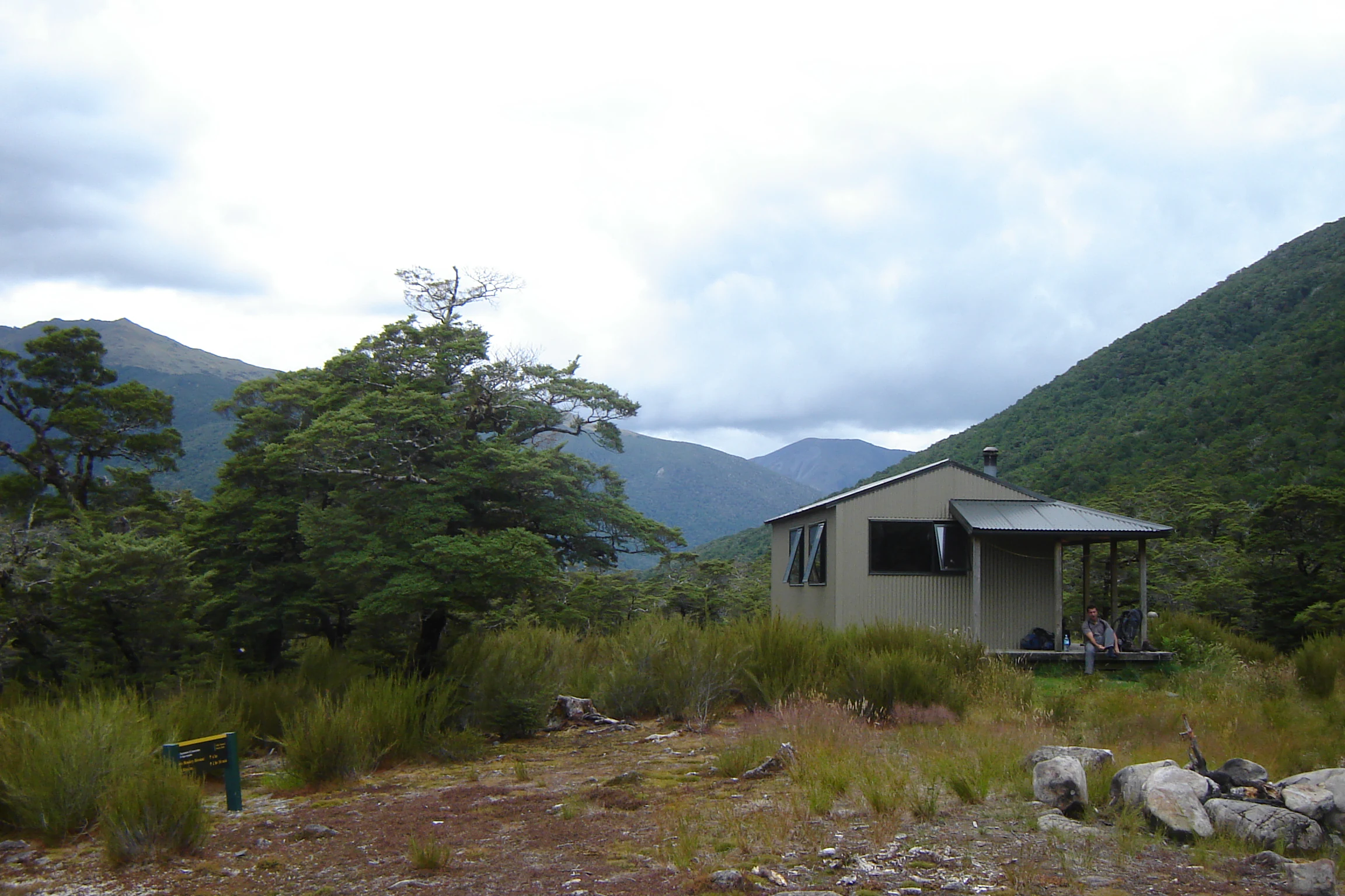
A small, light-colored backcountry hut with a porch nestled in a green valley surrounded by mountain slopes.
Nina Hut, a backcountry shelter located in Lake Sumner Forest Park.

Lake Sumner Forest Park history and protected-area timeline

Specific historical details about the establishment or earlier land use of Lake Sumner Forest Park are not extensively documented in available source material. The park is presently administered by the New Zealand Department of Conservation as part of the country's network of forest parks, which were developed to protect large tracts of native forest and provide for recreational use alongside ecological preservation. The park's identity as a forest park, rather than a national park, reflects this hybrid role of conservation and public access typical of forest park designations in New Zealand.

Lake Sumner Forest Park landscape and geographic character

The landscape of Lake Sumner Forest Park is shaped by the intertwined river systems of the Hurunui catchment and the broader terrain of the northern Canterbury high country. Steep, forested ridges rise from the valley floors, with the dense canopy of mature beech forest cloaking much of the middle elevations and giving way to subalpine vegetation toward the higher crests and saddles.

Lewis Pass itself sits within or at the edge of the park, anchoring its geography and providing the main highway corridor that links the park's eastern and western sides. Glacial and river-carved valleys cut through the forested ranges, producing a varied terrain that combines confined gorges with broader valley basins where the Hurunui River and its tributaries meander through gravel beds and pools.

Natural hot springs occur in several locations within the park, with the most accessible reportedly found above the Hurunui River between The Hurunui Hut and No. 3 Hut. These small geothermal features add an unusual and distinctive element to an otherwise deeply forested and river-dominated landscape, and they have become informal landmarks for backcountry travelers passing through the valley.

Lake Sumner Forest Park ecosystems, habitats, and plant life

The natural character of Lake Sumner Forest Park is dominated by extensive tracts of native southern beech forest, which cover the majority of the park's lower and mid-elevation slopes. Red beech and silver beech are representative of the canopy species that give these forests their dense, tall structure, filtering light through to a deep layer of leaf litter and undergrowth on the valley floors.

Above the beech belt, vegetation transitions into subalpine and high-country communities typical of northern Canterbury, with scrubland, tussock grasses, and hardy small trees occupying exposed ridges and saddles. The river systems throughout the park create riparian corridors with their own distinct plant communities, including areas of regenerating forest, shrubland, and gravelbed vegetation along the banks of the Hurunui and its tributaries.

Together, the park forms part of a larger ecological mosaic in the region, linking the protected forests of the Lewis Pass Scenic Reserve with those of Arthur's Pass National Park, and helping to maintain the connectivity of native habitat across this stretch of the main divide.

Lake Sumner Forest Park wildlife and species highlights

Specific information about individual species or wildlife populations in Lake Sumner Forest Park is limited in available source material. The park's extensive beech forest and remote river valleys would typically support birdlife characteristic of South Island high-country forest environments, along with the broader fauna associated with the transition zone between the Lewis Pass Scenic Reserve and Arthur's Pass National Park.

Wildlife in the forest park is best understood in the context of New Zealand's predator-managed mainland forests, where forest reserves and forest parks of this scale provide important habitat for native forest birds and freshwater species. The Hurunui River system running through the park also offers habitat for native freshwater fauna typical of high-country Canterbury rivers.

Lake Sumner Forest Park conservation status and protection priorities

Lake Sumner Forest Park is part of New Zealand's system of protected forest parks managed by the Department of Conservation, and its conservation significance lies primarily in the scale and continuity of its native forest cover. By protecting a substantial area of beech forest and associated high-country ecosystems, the park contributes to landscape-scale habitat connectivity between Lewis Pass Scenic Reserve and Arthur's Pass National Park.

This contiguous protected corridor is ecologically important because it helps maintain habitat for native species across a wide elevation range, from valley-floor beech forest to subalpine ridges. The forest park designation also allows for low-impact recreational use, including tramping along marked routes and stays at remote huts, while still maintaining the underlying protective intent of the reserve system.

Top sights and standout views in Lake Sumner Forest Park

Lake Sumner Forest Park stands out for the sheer scale of its native beech forest, the remoteness of its backcountry hut network, and the surprising presence of natural hot springs tucked into the Hurunui River valley. Its position between Lewis Pass Scenic Reserve and Arthur's Pass National Park gives it an important role as a connective piece of the protected landscape along the main divide.

The combination of rugged terrain, long tramping routes, accessible road entry points along State Highway 7, and easily visited hut-based hot springs makes it a distinctive destination for travelers seeking a quieter and more continuous South Island wilderness experience than what is typically offered in the more heavily visited national parks.

Best time to visit Lake Sumner Forest Park

Lake Sumner Forest Park's atmosphere is strongly seasonal, reflecting the wider climate of the north Canterbury high country. Warmer months tend to bring longer daylight hours and more stable conditions for backcountry tramping, while cooler months may bring snow to higher elevations and alter the character of the river valleys and beech forest.

Visitors interested in the iconic golden tones and dense moodiness of beech forest will find that the canopy shifts seasonally, with cooler months often producing frosty, atmospheric forest and warmer months delivering lush green growth. The Hurunui hot springs remain a notable draw regardless of season, though conditions underfoot and on the river can be more challenging after heavy rainfall or in colder weather.
Monthly climate preview

Long-term temperature ranges and monthly precipitation averages for Canterbury

Lake Sumner Forest Park Climate Normals and Annual Weather Patterns

Representative coordinate records show average monthly temperatures ranging from 1.63 degrees Celsius to 12.38 degrees Celsius alongside consistent precipitation throughout the year. Reviewing the comprehensive twelve-month profile provides deeper insight into measured long-term climate normals.
Annual mean7 °C
2 °C12 °C
Jan12°
Feb12°
Mar10°
Apr
May
Jun
Jul
Aug
Sep
Oct
Nov
Dec11°
Warmest month
February

12.4 °C

Coolest month
July

1.6 °C

Wettest month
June

4.4 mm/day

Driest month
February

3.2 mm/day

Park location guide

Geography guide, regional context, and park location map for Lake Sumner Forest Park

Lake Sumner Forest Park park geography, regions, and map view in New Zealand

Understand where Lake Sumner Forest Park sits in New Zealand through a broader geographic reading of the surrounding landscape, nearby location context, and its mapped position within the national park landscape.

How Lake Sumner Forest Park fits into New Zealand

New Zealand is an island nation in the southwestern Pacific Ocean comprising two main islands and numerous smaller islands. Located east of Australia across the Tasman Sea, it features varied topography with the Southern Alps running along the South Island and volcanic terrain on the North Island. The country was settled by Maori people between 1280 and 1350, followed by European exploration beginning in 1642, and became a Dominion in 1907 before gaining full independence in 1947.

Wider geography shaping Lake Sumner Forest Park in New Zealand

New Zealand lies in the southwestern Pacific Ocean, east of Australia across the Tasman Sea. The country consists of two main islands, the North Island and South Island, plus over 600 smaller islands. The North Island features volcanic plateaus and hills while the South Island is dominated by the Southern Alps mountain range. The country has a long coastline and is surrounded by the Pacific Ocean.

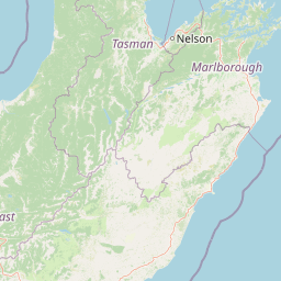
Map view of Lake Sumner Forest Park

Use this park location map to pinpoint Lake Sumner Forest Park in New Zealand, understand its exact geographic position, and read its mapped placement within the surrounding landscape more clearly.

Pigeon | © OpenStreetMap contributors

Location context for Lake Sumner Forest Park

Canterbury

Visualizing the beech forests, river valleys, and protected backcountry terrain

Lake Sumner Forest Park Photos and Landscape Scenery

Visual records capture the extensive beech forests, steep mountain ridges, and river valleys defining the protected landscape. Examining these photographs helps observers understand the remote backcountry terrain and wilderness character of the region.

A small, light-colored backcountry hut with a porch nestled in a green valley surrounded by mountain slopes.

A small rustic backcountry hut with green corrugated metal walls and roof set against a background of dense forest trees.

Park atlas

Compare adjacent mountain terrain and connected regional conservation landscapes

Parks Near Lake Sumner Forest Park and Surrounding Protected Natural Areas

Browse nearby national parks and protected areas sharing similar high country terrain and river valleys with Lake Sumner Forest Park. Expanding the geographic comparison reveals broader ecological corridors and continuous mountain wilderness across the region.
National parkNew Zealand
About 26 km away#1 closest

Southwest

Arthur's Pass National Park: Dramatic Alpine Protected Landscape in the Southern Alps

Explore the unique geography and mapped boundaries of this South Island national park.

Arthur's Pass National Park, a substantial protected area within New Zealand's Southern Alps, presents a compelling focus for geographic and atlas exploration. Characterized by dramatic alpine terrain shaped by ancient glacial forces, the park exhibits a striking ecological contrast between its drier eastern beech forests and wetter western rainforests. Users can delve into the mapped park boundaries and understand the regional landscape context of this unique protected area, making it a key destination for understanding New Zealand's natural geography.

Area
1,184.7 km²
Established
1929
IUCN
II
Relief
Mountain
National parkNew Zealand
About 38 km away#2 closest

Northeast

Nelson Lakes National Park: Alpine Geography and Glacial Lakes Atlas

Explore New Zealand's protected mountain terrain and natural landscapes.

Nelson Lakes National Park provides a deep dive into a dramatic alpine environment situated at the northern edge of New Zealand's Southern Alps. This national park is characterized by its striking glacial lakes, Rotoiti and Rotoroa, and the extensive mountain ranges that surround them, offering a rich context for understanding protected land distribution. Explore the park's mapped geography, its distinct beech forest ecosystems, and the rugged natural terrain that makes it a significant feature within the broader South Island landscape.

Area
1,018.8 km²
Established
1956
IUCN
II
Relief
Mountain
Protected landscapeSouth Island
About 57 km away#3 closest

Northwest

Victoria Forest Park: A Deep Dive Into New Zealand's Largest Protected Forest Landscape

Inland West Coast mountain ranges and beech forest ecosystems

Spanning over 200,000 hectares, Victoria Forest Park stands as a defining geographic feature of the South Island. It acts as a critical refuge for endemic species and preserves all five native beech tree types within a massive, continuous protected area. The landscape integrates rugged mountain ranges with deep river valleys and historical industrial artifacts, providing a comprehensive look at the intersection of conservation and regional history.

Area
2,069 km²
Established
1981
Relief
Mountain
Climate
Temperate
National parkWest Coast Region
About 64 km away#4 closest

Northwest

Paparoa National Park: Detailed Geographic Atlas of Karst Formations and Coastal Terrain

Discover protected landscape boundaries and unique New Zealand geology.

Paparoa National Park, located in the West Coast Region of New Zealand, offers a unique window into complex karst geology and dynamic coastal landscapes. This national park is characterized by extensive limestone cave systems, underground rivers, and the famous Pancake Rocks and Blowholes. The park's geography includes dramatic mountain terrain within the Paparoa Range and a striking coastline, providing a rich dataset for mapping protected area context and understanding regional natural features. It stands apart for its subterranean wonders and eroded limestone formations.

Area
429.7 km²
Established
1987
IUCN
II
Relief
Mountain
A soft watercolor illustration featuring a panoramic view of rolling green hills, distant mountains, a meandering stream, and wildflowers in the foreground.
Protected landscapeSouth Island
About 73 km away#5 closest

Southwest

Craigieburn Forest Park: Protected Alpine Landscape and Southern Alps Geography

High country terrain from beech forests to alpine ridges.

Situated along the eastern flanks of the Southern Alps, Craigieburn Forest Park offers a complex mountain geography that serves as both a recreational hub and an ecological restoration zone. The area features a clear transition from beech-clad valley floors and glacial terraces to wide tussock basins and craggy summits, providing a detailed look at the diverse natural terrain of the Canterbury region.

Area
446.948 km²
Established
1967
Relief
Mountain
Climate
Alpine
A horizontal watercolor illustration depicting a coastal landscape with winding light-colored sandbars, pale water channels, and soft green rolling hills under a muted pastel sky.
Regional parkCanterbury Region
About 87 km away#6 closest

Southeast

Northern Pegasus Bay Regional Park: Canterbury Coastal Geography and Protected Land Atlas

Mapping the beaches, estuaries, and dunes of Northern Pegasus Bay.

Northern Pegasus Bay spans a long, curving stretch of the Canterbury coastline on New Zealand's South Island. This regional park protects a range of coastal landforms, including pebbly beaches, dune systems, and the regionally significant Ashley Rakahuri Estuary. The geography reflects a dynamic exchange of sediment across multiple river mouths, creating a distinct environmental corridor between coastal communities and the sea.

Relief
Lowland
Climate
Temperate
Access
Easy access
Scope
Mixed
Watercolor painting of mountains, green valleys, and a winding river under a soft sky
National parkWest Coast Region
About 93 km away#7 closest

North

Kahurangi National Park: A National Park of Ancient Geology and Diverse Protected Landscapes in New Zealand

Explore the mapped natural terrain and regional geographic context.

Kahurangi National Park is distinguished by its extraordinary geological diversity, representing New Zealand's finest Paleozoic rock sequence and expansive karst features. Covering a vast area in the West Coast Region, it protects a remarkable array of natural landscapes, from coastal cliffs and nikau palm forests to alpine tussock basins and deep gorges. This national park is crucial for understanding New Zealand's natural heritage, offering a rich tapestry of mapped terrain and protected biodiversity for dedicated geographic exploration.

Area
5,193 km²
Established
1996
IUCN
II
Relief
Mixed relief
Regional parkCanterbury Region
About 95 km away#8 closest

South

Waimakariri River Regional Park: Geography and Protected Landscape Atlas for Canterbury

Braided river corridors and wetland habitats in the Canterbury Region

Waimakariri River Regional Park encompasses a significant managed corridor along the Waimakariri River, featuring an intricate mix of braided riverbeds, saltmarshes, and reforested land. This profile details the park topography, highlighting its role in regional flood management and its varied natural terrain across the Canterbury Plains, providing a clear geographic view of its multi-use protected boundaries.

Area
150 km²
Relief
Lowland
Access
Easy access
Scope
Terrestrial

Common questions about visiting, size, designation, and location context for Lake Sumner Forest Park

Lake Sumner Forest Park FAQs for park facts, access, geography, and protected area context

Find quick answers about Lake Sumner Forest Park, including protected-area facts, park geography, trail and visitor context, and how the park fits into its surrounding country and regional landscape.
MoriAtlas Explorer

Continue Your Protected Areas Search Across the Global Atlas

Deepen your exploration by continuing the structured search for national parks and protected areas worldwide. Utilize the comprehensive filtering capabilities to compare different conservation landscapes and refine your understanding of global park geography. Discover more about the distribution and characteristics of protected natural areas.

Global natural geography