

Mori Atlas logo
Nature reserveLake Urana Nature Reserve

Analyzing the salt lake fringe, dry box-pine forest, and semi-arid plains ecosystems

Lake Urana Nature Reserve: Mapped Protected Landscapes and Riverina Woodland Geography

Lake Urana Nature Reserve represents a critical protected landscape situated within the western Riverina plains of New South Wales. This compact nature reserve provides an essential habitat sample ranging from salt-lake shorelines and saltbush shrublands to yellow box and white cypress pine woodlands. By safeguarding these diverse environments, the area serves as a vital component in the broader conservation network protecting the Murray-Darling basin and native bird populations.

salt lakedry woodlandbox-pine forestRiverina plainsnature reservebirdwatching

Lake Urana Nature Reserve

Nature reserve

Park overview

Structured park overview, official facts, and landscape profile for Lake Urana Nature Reserve

Lake Urana Nature Reserve park facts, protected area profile, and essential visitor context

Review the core facts for Lake Urana Nature Reserve, including designation, size, terrain, visitor scale, habitats, and operating context in one park-focused overview.

About Lake Urana Nature Reserve

Lake Urana Nature Reserve sits on the western edge of the Riverina, one of Australia's most important agricultural regions but also a landscape of significant native ecological value. The reserve is compact, covering only a few square kilometres, but it captures several habitat elements typical of the inland plains of southern New South Wales: dry woodland, saltbush shrubland, grassy ground cover, and the shoreline of a seasonal salt lake.

The lake itself is central to the reserve's identity. Lake Urana is a shallow salt lake that fills intermittently, transforming the surrounding environment through cycles of wet and dry conditions. The changing water levels create pulses of productivity that attract waterbirds when the lake is full and support drought-adapted vegetation when it is dry. The reserve's woodland and shrubland communities have evolved alongside this variability, producing a patchwork of vegetation types unusually close together.

The reserve's sclerophyll woodland mixes broad-leaved eucalypts with cypress pine, a combination characteristic of the lighter soils of the western Riverina. Beneath the canopy, a diverse shrub and ground layer, including native grasses, herbs, and chenopod shrubs such as saltbush, adds structural complexity to the vegetation. A narrow band of red gum woodland along the lake shore adds an additional habitat layer associated with the lake's edge.

From a conservation perspective, the reserve contributes to protection of the broader Riverina plains landscape, much of which has been heavily modified for cropping and grazing. Its designation as a strict nature reserve places it among New South Wales's highest category of terrestrial protection. The reserve's overlap with the Riverina Plains Important Bird Area links it to international efforts to maintain habitat for the region's threatened bird species.

Quick facts and research context for Lake Urana Nature Reserve

Lake Urana Nature Reserve is a strict nature reserve covering roughly 302 hectares in the Riverina region of New South Wales. It lies adjacent to Lake Urana, a salt lake on the western Riverina plains near the small town of Urana. The park was formally gazetted in April 1996 and is managed by the NSW National Parks and Wildlife Service.

The reserve protects dry woodland dominated by yellow box and white cypress pine, fringed by a narrow band of red gum woodland near the lake shore. Its northern section overlaps the Riverina Plains Important Bird Area, an area recognized for supporting threatened plains-dependent birds. The combination of salt-lake shore, shrubland, and box-pine woodland creates conditions for both resident woodland species and seasonal waterbirds when the lake fills.

Protection and recognition

Examine the terrestrial protected area designation and management scope for Lake Urana Nature Reserve.

Lake Urana Nature Reserve Protection Status and Designated Scope

Lake Urana Nature Reserve maintains a documented terrestrial protection scope within the regional conservation network. Structured conservation records compile official designation history and international recognition data for this protected area.

Protection details

Protection scope
Terrestrial
Transboundary protection
No
Park context

Deeper park guide and search-rich context for Lake Urana Nature Reserve

Lake Urana Nature Reserve history, landscape, wildlife, and travel context

Explore Lake Urana Nature Reserve through its history, landscape character, ecosystems, wildlife, conservation priorities, cultural context, and seasonal travel timing in a structured park guide built for atlas discovery and search intent.

Why Lake Urana Nature Reserve stands out

Lake Urana Nature Reserve is best known for protecting a representative patch of Riverina woodland and salt-lake fringe habitat in a landscape otherwise dominated by agriculture. Its woodland mix of yellow box and white cypress pine, combined with salt-tolerant shrubs such as thorny saltbush and ruby saltbush, reflects the characteristic dry inland vegetation of the western Riverina. The reserve is also notable for its bird values. The northern part of the reserve sits within the Riverina Plains Important Bird Area, which has been identified by BirdLife International as important for the plains-wanderer, one of Australia's most threatened and distinctive grassland birds. This places the reserve within a wider conservation landscape for species dependent on semi-arid plains.
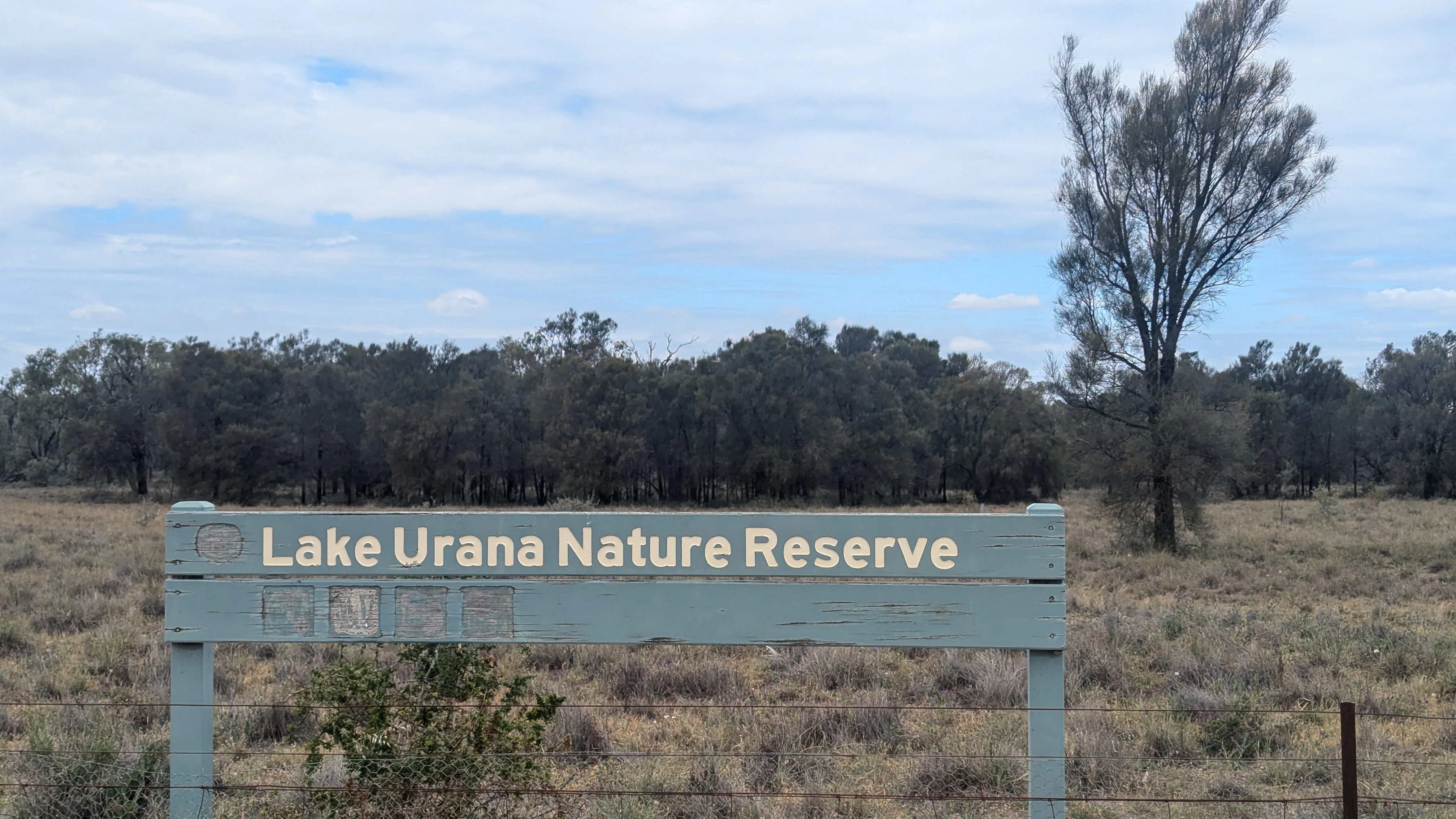
A pale green wooden park entrance sign reading Lake Urana Nature Reserve, set against a background of dry grasslands and scattered trees under a cloudy sky.
Entrance sign for the Lake Urana Nature Reserve in New South Wales.

Lake Urana Nature Reserve history and protected-area timeline

Lake Urana Nature Reserve was formally gazetted in April 1996 as a protected area under New South Wales conservation legislation. Its creation reflected growing recognition during the 1990s that small remnants of native vegetation in heavily cleared agricultural landscapes needed formal protection to safeguard their long-term ecological values.

The reserve was established around an existing patch of native woodland and shrubland adjacent to Lake Urana. The area was considered valuable because it retained examples of vegetation communities that had become scarce across the surrounding Riverina plains, where extensive clearing for cropping and grazing had reduced native habitat to isolated fragments. By placing the reserve under the management of the NSW National Parks and Wildlife Service, the state government gave it the highest level of protection available for terrestrial reserves in New South Wales.

Over time, the reserve has gained additional recognition through its inclusion in the Riverina Plains Important Bird Area, an identification by BirdLife International that links the site to broader conservation planning for threatened grassland and woodland birds of the inland plains. The reserve continues to be managed primarily for biodiversity conservation rather than recreation or tourism, consistent with its strict nature reserve classification.

Lake Urana Nature Reserve landscape and geographic character

The landscape of the Lake Urana Nature Reserve is shaped by its position on the flat western Riverina plains and by the presence of the nearby salt lake. The terrain is gently undulating at most, with subtle rises and flats that reflect the underlying geology of the Murray-Darling basin. Soils are typically light and often carry salt influence, supporting vegetation adapted to dry, sometimes saline conditions.

The most visible landscape feature is Lake Urana itself, a broad, shallow salt lake that lies immediately adjacent to the reserve. The lake has no permanent outflow and its water level varies dramatically with rainfall. In dry periods it can appear as a pale, cracked saltpan; in wetter years it fills with shallow water that attracts waterbirds and reshapes the shoreline ecology. This variability is the defining characteristic of the landscape and influences every other feature of the reserve.

Within the reserve, the landscape transitions from the open lakeshore through fringing red gum woodland into taller dry sclerophyll woodland on the slightly higher ground. The woodland canopy, dominated by yellow box and white cypress pine, gives the open interior of the reserve a light, parkland-like appearance typical of inland Australian box-pine forests. Shrub layers of saltbush and wattle create a denser, shrubby character in the more open and saline sections.

Lake Urana Nature Reserve ecosystems, habitats, and plant life

The reserve protects several interacting ecological communities typical of the western Riverina. Dry sclerophyll woodland of yellow box and white cypress pine covers much of the reserve's higher ground, representing one of the characteristic vegetation associations of inland southern New South Wales. Along the lake margin, a narrow band of red gum woodland adds a contrasting habitat tied directly to the lake's edge.

Beneath the canopy, the reserve has a rich shrub layer dominated by salt-tolerant species. Thorny saltbush, ruby saltbush, western golden wattle, emu bush, and other woody shrubs form dense thickets in places, providing cover for small animals and contributing to the structural diversity of the vegetation. The ground layer is particularly diverse: more than seventy species of native grasses and herbs have been recorded, including wiregrass, speargrass, and nodding chocolate lily. This diversity across multiple vegetation layers gives the reserve a much greater habitat complexity than its small area would suggest.

The lake and its seasonal flooding add another ecological dimension. When the lake fills, it produces wetland conditions that draw in waterbirds and create temporary shoreline habitats. When dry, the exposed saltpan and cracked sediment create harsh conditions that favour drought-adapted flora and fauna. The reserve's ecological character is therefore shaped by this rhythm between dry terrestrial vegetation and intermittent inundation.

Lake Urana Nature Reserve wildlife and species highlights

The reserve supports a range of native fauna typical of the western Riverina, including eastern grey kangaroos as a characteristic large mammal. Reptiles, small mammals, and insects typical of dry inland woodland and shrubland habitats are also expected to occur within the reserve, though detailed records in the available sources are limited.

Birds are the reserve's most diverse and best-documented wildlife group. At least thirty-seven bird species have been identified, encompassing woodland, shrubland, and grassland species that use the reserve year-round, as well as waterbirds that visit during wet periods. Wood ducks, Pacific black duck, grey teal, yellow-billed spoonbill, black-fronted dotterel, and magpie larks have all been recorded, particularly when the lake fills and provides feeding and roosting habitat.

The reserve's most significant wildlife value is its contribution to the conservation of the plains-wanderer and other threatened bird species of the Riverina plains. The northern half of the reserve falls within the Riverina Plains Important Bird Area, an area BirdLife International has identified as important for these species. This designation places the reserve within a wider conservation effort to maintain habitat connectivity for threatened grassland birds across a landscape otherwise dominated by agriculture.

Lake Urana Nature Reserve conservation status and protection priorities

Lake Urana Nature Reserve is managed as a strict nature reserve under New South Wales conservation legislation, the highest level of protection applied to terrestrial reserves in the state. The reserve's purpose is the long-term conservation of native vegetation and wildlife species in an area of the western Riverina that has experienced extensive historical clearing for agriculture.

The reserve's conservation value lies in the combination of habitat types it protects within a small area. By preserving dry box-pine woodland, saltbush shrubland, grassy ground cover, and fringing lakeside red gum woodland together, the reserve safeguards a representative cross-section of inland Riverina vegetation that has become increasingly fragmented across the surrounding landscape. The diversity of the understorey, with more than seventy native ground-cover species recorded, adds to the site's botanical significance.

Inclusion of the northern portion of the reserve within the Riverina Plains Important Bird Area extends its conservation importance to the regional and international scale. The area has been identified as supporting the plains-wanderer, a critically threatened bird that depends on native grasslands and shrublands of the inland plains. Through this recognition, the reserve contributes to conservation planning and habitat protection efforts that extend well beyond its own boundaries.

Lake Urana Nature Reserve cultural meaning and human context

Lake Urana and the surrounding plains lie within the broader cultural landscape of the Riverina, a region with a long history of Aboriginal presence prior to European pastoral expansion and later agricultural development. The area around the lake is dotted with sites and landscapes of significance to Aboriginal traditional owners, and salt lakes across the western Riverina have long held ecological and cultural importance to Aboriginal people.

The local town of Urana, from which the lake takes its name, developed as a small rural service centre in the late nineteenth century as European settlement expanded across the Riverina following the gold rushes and the growth of the wool industry. The transformation of the surrounding landscape through pastoral use and later cropping dramatically reduced the extent of native vegetation, leaving only scattered remnants like the woodland and shrubland now protected within the reserve. This history of landscape change gives the reserve an additional layer of cultural significance as one of the surviving fragments of the region's pre-agricultural environment.

Top sights and standout views in Lake Urana Nature Reserve

The reserve captures an unusually complete sample of western Riverina habitats in a compact area, from lakeshore saltpan to box-pine woodland and dense saltbush shrubland. The diversity of understorey plants, with more than seventy native ground-cover species recorded, gives the reserve a botanical richness that exceeds what its modest size might suggest.

Its integration into the Riverina Plains Important Bird Area gives the reserve relevance beyond its boundaries, linking it to wider efforts to protect the plains-wanderer and other threatened birds of the inland plains. For visitors interested in inland Australian ecosystems, the reserve offers a concise example of how woodland, shrubland, and seasonal lake ecology come together on the flat country of the Murray-Darling basin.

Best time to visit Lake Urana Nature Reserve

The character of a visit to Lake Urana Nature Reserve varies with the state of the lake and the seasons. Spring and early summer are typically the most pleasant times to visit, when temperatures are milder, native grasses and herbs in the ground layer are flowering, and many woodland birds are active. The woodland canopy at this time of year is relatively open and easy to observe.

Seasonal flooding of Lake Urana adds an important dimension to any visit. When the lake fills, waterbirds arrive in greater numbers and the lakeshore red gum woodland and exposed shoreline become more ecologically active, providing a very different experience from dry periods. In drier conditions, the lake may appear as a pale saltpan with sparse vegetation, and the focus of a visit shifts more toward the woodland and shrubland habitats. Summer in this part of inland New South Wales can be very hot, while winter mornings may be cool and foggy.
Monthly climate preview

Long term representative temperature and precipitation rhythms across twelve monthly cycles

Lake Urana Nature Reserve Climate Normals and Annual Weather Patterns

Representative coordinates record sustained temperature shifts alongside steady daily precipitation averages throughout the year at Lake Urana Nature Reserve. Reviewing the complete monthly climate profile reveals precise long term normals for temperature extremes and precipitation patterns.
Annual mean16 °C
8 °C26 °C
Jan26°
Feb25°
Mar21°
Apr16°
May12°
Jun
Jul
Aug
Sep12°
Oct16°
Nov20°
Dec23°
Warmest month
January

25.9 °C

Coolest month
July

7.9 °C

Wettest month
June

1.6 mm/day

Driest month
April

1 mm/day

Park location guide

Geography guide, regional context, and park location map for Lake Urana Nature Reserve

Lake Urana Nature Reserve park geography, regions, and map view in Australia

Understand where Lake Urana Nature Reserve sits in Australia through a broader geographic reading of the surrounding landscape, nearby location context, and its mapped position within the national park landscape.

How Lake Urana Nature Reserve fits into Australia

Australia is a constitutional monarchy and federal parliamentary democracy comprising six states and ten territories. With a population of nearly 28 million, it is one of the world's most urbanised countries, with most people concentrated on the eastern seaboard. The country has a high Human Development Index and is known for its cultural diversity, ancient Aboriginal heritage, and unique wildlife.

Wider geography shaping Lake Urana Nature Reserve in Australia

Australia occupies the entire Australian continent, the island of Tasmania, and numerous smaller islands. It is the world's flattest and driest inhabited continent, featuring vast deserts in the interior (the Outback), tropical rainforests along the eastern coast, and a coastline bordering the Indian and Pacific Oceans.

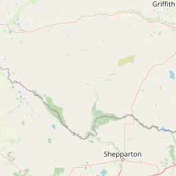
Map view of Lake Urana Nature Reserve

Use this park location map to pinpoint Lake Urana Nature Reserve in Australia, understand its exact geographic position, and read its mapped placement within the surrounding landscape more clearly.

Pigeon | © OpenStreetMap contributors

Location context for Lake Urana Nature Reserve

New South Wales

Visualizing salt lake shores, dry box pine woodlands, and protected habitats across the Riverina plains

Lake Urana Nature Reserve Photos and Landscape Scenery

Examine detailed photographs capturing the salt lake shoreline, box pine woodland canopy, and dry shrublands defining Lake Urana Nature Reserve. Visual documentation reveals the flat terrain, fluctuating water levels, and native vegetation characteristic of this protected inland Australian ecosystem.

A pale green wooden park entrance sign reading Lake Urana Nature Reserve, set against a background of dry grasslands and scattered trees under a cloudy sky.

Park atlas

Compare regional protected landscapes, dry woodlands, and salt lake habitats across the Riverina plains.

Explore Other Parks Near Lake Urana Nature Reserve and Surrounding Protected Areas

Browsing other protected areas near Lake Urana Nature Reserve reveals a connected network of dry woodlands, seasonal wetlands, and salt-lake fringe habitats across the western plains. Continuing into related regional parks provides broader geographic context for comparing the native flora, fauna, and inland ecosystems of southern New South Wales.
National parkNew South Wales
About 62 km away#1 closest

North

Murrumbidgee Valley National Park: National Park with Mapped Protected Boundaries in New South Wales

Regional geography and landscape context for this protected area.

Murrumbidgee Valley National Park is recognized as a national park, offering critical insights into protected land distribution within New South Wales. This destination facilitates an atlas-style exploration of its geographic identity, mapped boundaries, and its role as a defined natural landscape within the broader region. Understanding this park's protected status and geographic placement is key for detailed map-based discovery.

Area
477.03 km²
Established
2010
IUCN
II
Relief
Lowland
Nature reserveNew South Wales
About 73 km away#2 closest

Southeast

Wiesners Swamp Nature Reserve: Mapping the Floodplain Landscapes of New South Wales

A preserved ephemeral wetland and woodland habitat

Wiesners Swamp Nature Reserve represents a critical protected wetland basin in the South Western Slopes of New South Wales. The reserve provides a mapped view of seasonal floodplain dynamics, including river red gum woodland and woodland patches on higher ground that support local waterbirds and native mammals.

Area
1.03 km²
Established
1996
IUCN
Ia
Relief
Lowland
National parkNew South Wales
About 76 km away#3 closest

Southwest

Murray Valley National Park: Explore its Mapped Boundaries and Regional Geography in New South Wales

Protected landscape identity and geographic context.

Gain a structured understanding of Murray Valley National Park, a designated national park within New South Wales. This detail page provides essential geographic context, highlighting the park's mapped boundaries and its significance as a protected natural landscape. Utilize this entry point for comprehensive atlas-based exploration of its unique regional setting and terrain.

Area
416.01 km²
Established
2010
IUCN
II
Relief
Lowland
National parkAustralia
About 88 km away#4 closest

South

Warby-Ovens National Park: Protected Landscape and Geographic Atlas Entry

Discover its Box-Ironbark forests and mapped regional terrain.

Warby-Ovens National Park is a protected national park situated in northeastern Victoria, Australia, covering 14,655 hectares of distinctive landscape. It is internationally recognized as an Important Bird Area, primarily for its significant Box-Ironbark forest ecosystem that supports numerous threatened woodland bird species. The park's geography features low granite hills and rolling terrain, with the Ovens River flowing through its northern section. This detail page provides structured information on its protected boundaries, natural landscape characteristics, and its place within regional geography.

Area
146.55 km²
Established
2010
IUCN
II
Relief
Upland
Watercolor illustration of a river landscape with green hills, trees, and pink reeds
National parkAustralia
About 90 km away#5 closest

Southwest

Barmah National Park National Park: World's Largest River Red Gum Forest Landscape

Explore Mapped Boundaries and Wetland Geography

Barmah National Park in Victoria, Australia, is renowned for protecting the largest river red gum floodplain forest on Earth, a globally significant Ramsar-listed wetland. This protected area's landscape is defined by majestic eucalypts bordering freshwater marshes along the Murray River. Dive into its distinct geography, mapped terrain, and the protected status of this remarkable ecosystem, offering unparalleled opportunities for understanding regional natural landscapes and conservation.

Area
285.21 km²
Established
2010
IUCN
II
Relief
Lowland
National parkNew South Wales
About 91 km away#6 closest

Northwest

Oolambeyan National Park National Park: Discover its Mapped Geography and Protected Landscape

Explore the protected area and regional context of New South Wales.

Delve into Oolambeyan National Park, a key national park within New South Wales, Australia. This entry provides essential geographic context, detailing the park's mapped boundaries and its identity as a protected landscape. It serves as a foundation for understanding the park's contribution to the regional atlas and offers a distinct perspective on the natural geography of the area.

Area
222.31 km²
Established
2001
IUCN
II
Access
Moderate access
National parkAustralia
About 99 km away#7 closest

Southeast

Chiltern-Mt Pilot National Park: Box-Ironbark Forest & Mapped Landscape

Explore its protected areas and regional geographic context.

Chiltern-Mt Pilot National Park preserves a significant portion of Victoria's box-ironbark forest, an ecosystem vital for threatened species and rich biodiversity. This park showcases varied terrain, from sedimentary hills to granite landscapes, offering a compelling subject for geographic study. Understand its mapped extent and its role within the broader regional geography, providing deep insights for atlas-based exploration.

Area
215.6 km²
Established
2002
IUCN
II
Relief
Mixed relief
National parkNew South Wales
About 101 km away#8 closest

Southeast

Benambra National Park: New South Wales Protected Area and Great Yambla Range Map

Explore mapped terrain and woodland ecosystems.

Benambra National Park serves as a key protected area in New South Wales, preserving crucial white box and Red Box woodland communities against a backdrop of the Great Yambla Range's dramatic topography. This national park is significant for its role in conserving habitat for at least twelve threatened bird species and its unique geological features, including cliff faces and flat-topped peaks. Understanding the park's mapped boundaries and its place within the South West Slopes region offers valuable context for geographic discovery and the study of Australia's natural landscapes.

Area
13.99 km²
Established
2001
IUCN
II
Relief
Mixed relief

Common questions about visiting, size, designation, and location context for Lake Urana Nature Reserve

Lake Urana Nature Reserve FAQs for park facts, access, geography, and protected area context

Find quick answers about Lake Urana Nature Reserve, including protected-area facts, park geography, trail and visitor context, and how the park fits into its surrounding country and regional landscape.
MoriAtlas Explorer

Continue Your Protected Areas Search Across the Global Atlas

Deepen your exploration by continuing the structured search for national parks and protected areas worldwide. Utilize the comprehensive filtering capabilities to compare different conservation landscapes and refine your understanding of global park geography. Discover more about the distribution and characteristics of protected natural areas.

Global natural geography