

Mori Atlas logo
National parkLambir Hills National Park

Discover the mapped boundaries and regional atlas significance of this key Malaysian national park.

Lambir Hills National Park: Sarawak's Protected Landscape Identity and Geographic Context

(Taman Negara Bukit Lambir)

Lambir Hills National Park stands as a significant protected area within the diverse geography of Sarawak, Malaysia. This page offers a detailed atlas-style exploration, focusing on the park's unique landscape context and its position within the Borneo region. Users can delve into the mapped boundaries and understand the protected land's role in the broader geographic atlas, providing a factual foundation for discovering Sarawak's natural heritage.

National ParkTropical RainforestBiodiversity HotspotBorneoDipterocarp ForestTree Diversity

Lambir Hills National Park

National park

Park overview

Structured park overview, official facts, and landscape profile for Lambir Hills National Park

Lambir Hills National Park park facts, protected area profile, and essential visitor context
Review the core facts for Lambir Hills National Park, including designation, size, terrain, visitor scale, habitats, and operating context in one park-focused overview.

About Lambir Hills National Park

Lambir Hills National Park occupies a significant position among Southeast Asia's protected areas as the last remaining tract of intact lowland dipterocarp forest in Sarawak. The park's location in northeastern Borneo places it within a region of globally exceptional biodiversity, and its relatively small size of 6,952 hectares belies its ecological importance. The mixed dipterocarp forest that covers the majority of the park is characterized by members of the Dipterocarpaceae family, including Shorea and Dryobalanops species, which dominate the canopy and emergents. Smaller patches of kerangas heath forest add ecological variety to the landscape. The park's elevation range from 150 to 465 meters creates subtle but meaningful habitat gradients that contribute to species diversity. Beyond its conservation value, the park serves as an important recreational resource for residents of Miri and visitors to the region, offering natural beauty, hiking opportunities, and wildlife observation within a manageable distance from the city.

Quick facts and research context for Lambir Hills National Park

Lambir Hills National Park spans 6,952 hectares in northeastern Borneo, within the Miri Division of Sarawak, Malaysia. The terrain consists of rolling hills and valleys covered by mixed dipterocarp forest at elevations between 150 and 465 meters above sea level. The park is recognized internationally for its extraordinary plant diversity, particularly the Lambir Hills Forest Dynamics Plot where researchers have recorded over 1,175 tree species within a 52-hectare study area, a figure that may represent the highest tree species diversity in the Old World. Wildlife surveys have documented 237 bird species, 64 mammal species, 46 reptile species, and 20 frog species within the park boundaries.

Park context

Deeper park guide and search-rich context for Lambir Hills National Park

Lambir Hills National Park history, landscape, wildlife, and travel context
Explore Lambir Hills National Park through its history, landscape character, ecosystems, wildlife, conservation priorities, cultural context, and seasonal travel timing in a structured park guide built for atlas discovery and search intent.

Why Lambir Hills National Park stands out

Lambir Hills National Park is best known for its exceptional tree species diversity, which places it among the most botanically rich forests on Earth. The 52-hectare Forest Dynamics Plot established in 1991 by researchers from Sarawak Forest Department, Harvard University, and Osaka City University has documented more than 1,175 tree species, likely the highest diversity of any forest in the Old World. The park features the towering tapang tree (Koompassia excelsa), which can exceed 80 meters in height and attracts honey bees that build massive hives in its branches. It is also notable for the pitcher plant Nepenthes hispida, which is found nowhere else on Earth, and supports nearly 80 fig species. The park offers research infrastructure including tree towers, a canopy walkway, and a canopy crane that allow scientists to study the forest's vertical structure.

Lambir Hills National Park history and protected-area timeline

Lambir Hills National Park was established in 1975, designating the area as a protected national park under Malaysian law. The creation of the park came at a critical juncture in Sarawak's environmental history, as lowland forests across the state were increasingly subjected to logging pressure. By protecting this tract of forest, authorities ensured the preservation of an ecological system that would otherwise have been largely converted. The year 1991 marked a significant milestone in the park's scientific history when the Sarawak Forest Department partnered with the Center for Tropical Forest Science at Harvard University and the Plant Ecology Laboratory of Osaka City University, Japan, to establish the Lambir Hills Forest Dynamics Plot. This research initiative transformed the park into a major site for tropical forest ecology studies and contributed substantially to global understanding of forest dynamics and biodiversity patterns.

Lambir Hills National Park landscape and geographic character

The terrain of Lambir Hills National Park consists of undulating hills and valleys carved by natural watercourses, with elevations ranging from 150 meters in the lower areas to 465 meters at the summit of Bukit Lambir, the park's highest point. The landscape is characterized by dense forest cover that creates a layered canopy structure, with emergents rising above the general canopy level. Numerous streams traverse the park, feeding waterfalls and creating natural pools that have become popular visitor destinations. The Latak Waterfall, accessible via a popular trail, features a 25-meter drop into a large natural pool surrounded by steep rock walls. Other trails connect to additional waterfalls and bathing areas throughout the park. The forest floor is typically steep in places, with the trail to the summit requiring several hours of hiking and presenting challenges for less experienced visitors.

Lambir Hills National Park ecosystems, habitats, and plant life

The ecological character of Lambir Hills National Park is defined by its lowland dipterocarp forest, which represents the dominant vegetation type across most of the protected area. The Dipterocarpaceae family dominates the tree community, with species of Shorea and Dryobalanops forming the canopy backbone. This forest type supports extraordinarily high species diversity, with the Forest Dynamics Plot documenting over 1,175 tree species within just 52 hectares, a figure that appears to exceed any comparable forest in the Old World. The diversity extends beyond trees to include remarkable richness in figs, with approximately 80 Ficus species recorded. The park also supports specialized plant communities, including the kerangas heath forest on poorer soils and the remarkable ant-plant symbiosis involving several Macaranga species whose hollow stems house protective ant colonies. The endemic pitcher plant Nepenthes hispida is found only in this park and its immediate surroundings, representing a species of significant botanical interest.

Lambir Hills National Park wildlife and species highlights

The vertebrate fauna of Lambir Hills National Park includes 237 recorded bird species, 64 mammal species, 46 reptile species, and 20 frog species. However, recent surveys conducted between 2003 and 2007 revealed concerning population declines, with researchers failing to locate approximately 20 percent of previously recorded bird species and 22 percent of mammal species. The losses included half of the park's primate species and six of seven hornbill species, suggesting that even protected areas face significant pressure from hunting and habitat fragmentation. Large mammals such as gibbons and sun bear are now absent or very rare, likely due to the park's relatively small size and illegal hunting pressure. The invertebrate fauna includes the striking Rajah Brooke's Birdwing butterfly (Togronoptera brookiana) and more than 300 ant species, while leeches are notably rare in the park.

Lambir Hills National Park conservation status and protection priorities

Lambir Hills National Park represents a critical conservation stronghold as the last intact patch of lowland dipterocarp forest remaining in Sarawak. The park's designation as IUCN Category II reflects its status as a national park with primary protection objectives. Its significance extends beyond Sarawak, as the forest supports species populations that have been largely eliminated from logged and converted landscapes across Borneo. The Forest Dynamics Plot represents one of the most intensively studied tropical forest plots in the world, providing long-term data on tree growth, mortality, and population dynamics that inform conservation and forest management strategies. The park's high species diversity, including endemic and restricted-range species like Nepenthes hispida, adds to its conservation importance. However, the documented population declines in recent decades highlight the challenges facing even protected areas and underscore the need for effective anti-poaching measures and habitat management.

Lambir Hills National Park cultural meaning and human context

Lambir Hills National Park is located in the heart of Sarawak's oil palm and timber country, where the tension between economic development and forest conservation has shaped land use decisions for decades. The park's Malay name, Taman Negara Bukit Lambir, reflects its status within Malaysia's national park system. Indigenous communities in the broader region maintain traditional relationships with forest landscapes, though the park itself is managed primarily as a scientific and recreational resource. The park's proximity to Miri, approximately 40 minutes by road, makes it a day-trip destination for both local residents and tourists, and the visitor economy contributes to local community awareness of the park's value.

Top sights and standout views in Lambir Hills National Park

Lambir Hills National Park offers several standout features that distinguish it from other protected areas in Borneo. The world-record tree species diversity documented in the Forest Dynamics Plot makes it a pilgrimage site for tropical botanists and ecologists. The towering tapang trees, reaching heights exceeding 80 meters, create an impressive canopy landscape. The Latak Waterfall and its large bathing pool provide accessible natural beauty for general visitors. The network of hiking trails, ranging from short easy walks to challenging summit treks, accommodates various fitness levels. The research infrastructure, including tree towers, canopy walkway, and canopy crane, provides unique opportunities to experience the forest at multiple vertical levels. The park supports populations of hornbills, one of Borneo's most iconic bird groups, though their numbers have declined.

Best time to visit Lambir Hills National Park

The park can be visited throughout the year, given its location in the tropical rainforest zone of Borneo. The dry season typically offers more comfortable conditions for hiking, though rainfall occurs in all months. Weekends tend to be busier, especially as many visitors from Miri take day trips to the park. For those seeking a quieter experience, weekday visits may offer more solitude on the trails. The dry months from March to October generally provide better conditions for extended hikes and wildlife viewing, while the wetter months from November to February can still be enjoyed but may involve more challenging trail conditions.
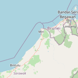

Park location guide

Geography guide, regional context, and park location map for Lambir Hills National Park

Lambir Hills National Park park geography, regions, and map view in Malaysia
Understand where Lambir Hills National Park sits in Malaysia through a broader geographic reading of the surrounding landscape, nearby location context, and its mapped position within the national park landscape.

How Lambir Hills National Park fits into Malaysia

Malaysia is a federal constitutional monarchy located in Southeast Asia. The country consists of 13 states and three federal territories, divided by the South China Sea into Peninsular Malaysia on the Indochinese Peninsula and East Malaysia on the island of Borneo. With a population of over 34 million, it achieved independence from Britain in 1957 and became a modern federation in 1963. The country is recognized for its multicultural population, tropical climate, and significant economic role in the region.

Wider geography shaping Lambir Hills National Park in Malaysia

Malaysia occupies a strategic position in Southeast Asia, split by the South China Sea into two distinct regions. Peninsular Malaysia lies on the Indochinese Peninsula, sharing a land border with Thailand to the north and maritime borders with Singapore, Vietnam, and Indonesia. East Malaysia occupies the northern portion of Borneo, sharing land borders with Brunei and Indonesia, and maritime borders with the Philippines and Vietnam. The country's terrain includes coastal plains, mountain ranges such as the Titiwangsa in the peninsula, and extensive tropical rainforests.

Map view of Lambir Hills National Park

Use this park location map to pinpoint Lambir Hills National Park in Malaysia, understand its exact geographic position, and read its mapped placement within the surrounding landscape more clearly.

Pigeon | © OpenStreetMap contributors

Location context for Lambir Hills National Park

Sarawak
Park atlas

Trace the regional park geography of Sarawak, Borneo, to compare protected landscapes and conservation areas.

Explore Other National Parks and Protected Areas Near Lambir Hills National Park
After exploring Lambir Hills National Park, browse additional national parks and protected areas across Sarawak and the wider Borneo island region. Compare diverse tropical rainforests, lowland dipterocarp forests, and unique wildlife habitats within a broader context of similar conservation landscapes.
Watercolor illustration of a landscape with green hills, trees, and a valley
National parkSarawak

Niah National Park: Sarawak's Protected National Park Geography and Mapped Landscape

Explore protected area boundaries and regional context within Sarawak

Niah National Park represents a significant protected national park, offering a distinct geographic and landscape identity within Sarawak, Malaysia. This resource facilitates the exploration of its mapped boundaries and its place within the regional atlas of Borneo. Users can delve into the specific geography of this protected area, understanding its landscape characteristics and its contribution to the broader conservation mapping of the region.

Established
1974
Relief
Mountain
Access
Moderate access
Scope
Terrestrial
National parkSarawak

Loagan Bunut National Park: Protected Landscape in Sarawak, Malaysia

Explore the mapped geography and natural terrain of this national park.

This page offers a detailed atlas-style exploration of Loagan Bunut National Park, situated in Sarawak, Malaysia. Understand the park's designation as a national park and its place within the mapped geography of Borneo. It provides essential context for appreciating the protected landscape and its regional significance.

Area
100 km²
Established
1990
IUCN
II
Scope
Terrestrial
Nature reserveBrunei

Luagan Lalak Forest Recreation Park Nature Reserve: Brunei's Pristine Freshwater Swamp Landscape

Explore mapped protected-area geography and unique wetland terrain.

Luagan Lalak Forest Recreation Park, a protected nature reserve in Brunei, preserves a rare and visually distinctive freshwater swamp ecosystem. Characterized by dark, tranquil waters and vast fields of purun grass, this natural wetland offers a unique landscape context and is a prime location for observing its rich biodiversity, especially its notable birdlife. The park's preservation as an intact swamp environment within a recreational area highlights its ecological importance for regional geography and protected-area mapping.

Area
2.7 km²
Established
1980
IUCN
II
Visitors
4.2K annual
Protected areaBrunei

Tasek Merimbun Heritage Park: Protected Landscape Identity and Geographic Atlas

Mapped boundaries and regional natural context for this Brunei protected area.

Tasek Merimbun Heritage Park represents a distinct protected area within the geography of Brunei. This page provides detailed insight into its protected landscape, offering a map-centric view of its boundaries and its placement within the broader natural context of Borneo. Understand the park's geographic significance and explore its unique attributes for structured atlas exploration.

Area
78 km²
Established
1984
Climate
Tropical
Access
Easy access
National parkMarudi District

Gunung Mulu National Park: A Protected National Park with Distinct Geographic Identity in Marudi District

Explore its mapped protected area and regional landscape.

Gunung Mulu National Park stands as a key protected area within Marudi District, Malaysia, offering critical insights into the region's natural geography. This national park entity provides a focal point for understanding mapped protected landscapes and their specific geographic characteristics. Users can explore the park's boundaries and its role within the wider atlas of Malaysian natural areas, gaining a solid foundation in its conservation geography.

Area
528.64 km²
Established
1974
IUCN
II
Relief
Mountain
National parkSarawak

Gunung Buda National Park: Sarawak National Park Protected Landscape and Geography

Explore the mapped boundaries and regional context of this Malaysian national park.

Gunung Buda National Park is a significant protected area within Sarawak, Malaysia, contributing to the region's diverse geography. As a national park, it offers specific insights into mapped protected lands, providing a focal point for understanding Borneo's natural landscapes. This entry details its geographic identity and its role as a protected natural space, crucial for any atlas-driven exploration of East Malaysia's conservation areas.

Area
66.2 km²
Established
2001
IUCN
II
Relief
Mountain
National parkBintulu Division

Bukit Tiban National Park: National Park Protected Area with Mapped Boundaries

Discover its geographic setting within Bintulu Division.

Bukit Tiban National Park stands as a significant protected natural area, offering a deep dive into its specific geography and mapped landscape. As a national park within Bintulu Division, it provides crucial atlas-level insight into regional protected lands. Explore the precise location and understand its context within Malaysia's network of natural conservation areas.

Area
96 km²
Established
2000
IUCN
II
Relief
Upland
Protected areaBrunei-Muara District

Bukit Shahbandar Forest Recreation Park: Protected Area with Ridge Landscape & Hiking Trails

Explore Brunei's unique recreational forest terrain and mapped natural features.

Bukit Shahbandar Forest Recreation Park is a notable protected area within the Brunei-Muara District, distinguished by its prominent grassy ridge and a network of challenging hiking trails that traverse its varied terrain. The park's landscape is characterized by rolling hills, including peaks that reach nearly 470 feet, offering strategic vantage points. As a recreational forest, it provides a distinct example of protected land use, blending modified natural vegetation with opportunities for outdoor activity and geographic discovery. Its unique topography and trail system offer a clear focus for atlas-based exploration.

Area
2.34 km²
Established
1998
IUCN
II
Visitors
35.5K annual

Common questions about visiting, size, designation, and location context for Lambir Hills National Park

Lambir Hills National Park FAQs for park facts, access, geography, and protected area context
Find quick answers about Lambir Hills National Park, including protected-area facts, park geography, trail and visitor context, and how the park fits into its surrounding country and regional landscape.
MoriAtlas Explorer

Continue Your Protected Areas Search Across the Global Atlas

Deepen your exploration by continuing the structured search for national parks and protected areas worldwide. Utilize the comprehensive filtering capabilities to compare different conservation landscapes and refine your understanding of global park geography. Discover more about the distribution and characteristics of protected natural areas.

Global natural geography
