
Mori Atlas logo
Protected landscapeLandschaftsschutzgebiet Arnsberg

Exploring the forested hills, rolling terrain, and historical topography of this Sauerland protected area

Landschaftsschutzgebiet Arnsberg: A Mapped Protected Landscape within Hochsauerlandkreis

Landschaftsschutzgebiet Arnsberg serves as a vital protected landscape covering large portions of the municipal territory of Arnsberg in the Hochsauerlandkreis district of Germany. This extensive area is characterized by rolling hilly relief, significant spruce and beech forest cover, and diverse open land patches that frame the local urban environment. Beyond its natural forested character, the landscape contains historical remnants of early mining and ancient hollow ways that reveal the cultural topography of the region.

landscape protection areaSauerlandNorth Rhine-Westphaliaforested landscapespruce forestbeech forest
Stylized digital illustration showing a waterfall tumbling from high cliffs into a winding river, framed by foreground forest trees, with light rays filtering through the canopy.

Landschaftsschutzgebiet Arnsberg

Protected landscape

Park overview

Structured park overview, official facts, and landscape profile for Landschaftsschutzgebiet Arnsberg

Landschaftsschutzgebiet Arnsberg park facts, protected area profile, and essential visitor context

Review the core facts for Landschaftsschutzgebiet Arnsberg, including designation, size, terrain, visitor scale, habitats, and operating context in one park-focused overview.

About Landschaftsschutzgebiet Arnsberg

Landschaftsschutzgebiet Arnsberg is one of the designated landscape protection areas (Landschaftsschutzgebiete) within the Hochsauerlandkreis, the administrative district in the Sauerland region of North Rhine-Westphalia. The protection area covers most of the undeveloped land within the municipal territory of Arnsberg that lies outside stricter nature reserves, settlement zones, and unzoned areas.

Forest is the dominant land cover in the protected area, with smaller parcels used for Christmas tree, decorative greenery, and tree nursery cultivation, along with limited open-land areas. These open areas consist almost entirely of intensively used grassland and arable fields. Woodland stands are predominantly composed of spruce, with beech also playing a substantial role in many areas.

The terrain throughout the protected landscape is generally undulating, contributing to the scenic quality of the area. In addition to its natural value, the landscape contains the cultural-historical traces of the region's mining heritage and the remains of historic hollow ways that once served as connecting routes through the Sauerland hills.

Quick facts and research context for Landschaftsschutzgebiet Arnsberg

Landschaftsschutzgebiet Arnsberg is a Schutzgebiet (protected landscape) within the city limits of Arnsberg in the Hochsauerlandkreis, North Rhine-Westphalia. It was first established in 1998 at approximately 8,375 hectares and was re-designated in 2021 at about 5,796 hectares across 219 separate sub-areas. The area belongs administratively to the Hochsauerlandkreis, which acts as the lower landscape authority. Designated land uses outside strict nature reserves, agricultural zones, and undeveloped unzoned areas are largely captured by this protection. The area sits within the broader Sauerland natural region and contributes to the Natura 2000 network.

Protection and recognition

Documented terrestrial conservation scope and official establishment chronology

Landschaftsschutzgebiet Arnsberg Protection Status and Designation History

Terrestrial protection status for Landschaftsschutzgebiet Arnsberg establishes a formal designation baseline recorded in 2021. Structured conservation metrics outline documented management scope and territorial framework parameters without external international recognition listings.

Protection details

Protection scope
Terrestrial
Designated year
2021
Transboundary protection
No
Park context

Deeper park guide and search-rich context for Landschaftsschutzgebiet Arnsberg

Landschaftsschutzgebiet Arnsberg history, landscape, wildlife, and travel context

Explore Landschaftsschutzgebiet Arnsberg through its history, landscape character, ecosystems, wildlife, conservation priorities, cultural context, and seasonal travel timing in a structured park guide built for atlas discovery and search intent.

Why Landschaftsschutzgebiet Arnsberg stands out

Landschaftsschutzgebiet Arnsberg is best known for safeguarding a representative forested section of the Sauerland landscape around the city of Arnsberg. Its character is shaped by rolling relief, large stretches of spruce and beech woodland, and the inclusion of small open-land patches. The area also contains visible traces of medieval and early modern mining, as well as hollow-way remnants of older route connections.
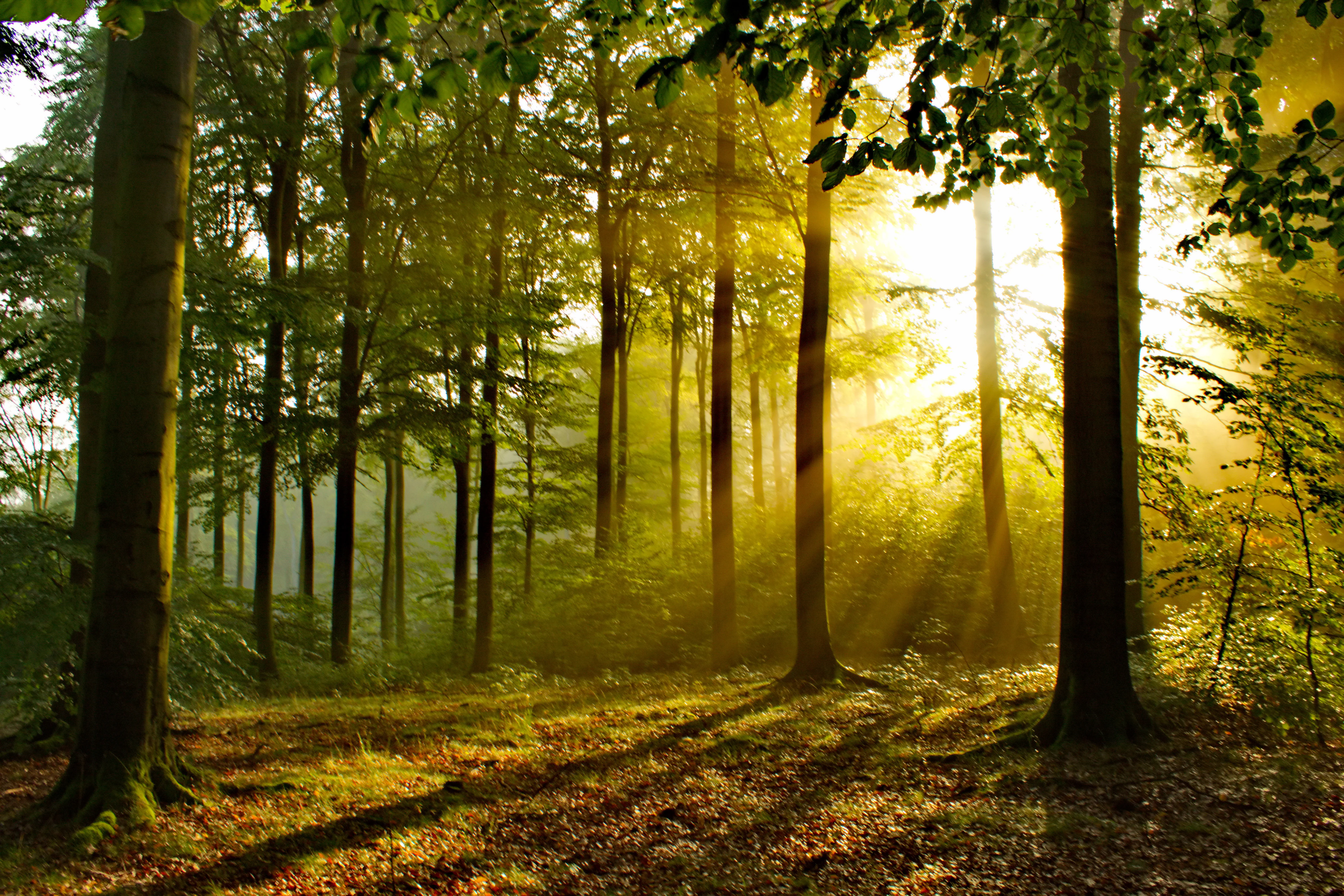
Sunlight rays streaming through a dense forest canopy at sunrise, illuminating the trunks of tall trees and the leafy forest floor.
Golden sunrise light filtering through the trees of Arnsberger Wald.

Landschaftsschutzgebiet Arnsberg history and protected-area timeline

Landschaftsschutzgebiet Arnsberg was first officially designated in 1998 as part of the Arnsberg landscape plan adopted by the district council (Kreistag) of the Hochsauerlandkreis. At its original designation the area covered approximately 8,375 hectares.

In 2021 the Hochsauerlandkreis district council re-adopted the Arnsberg landscape plan, leading to a renewed designation of the protected landscape with a significantly reduced footprint. The reduction reflected the establishment of new nature reserves within the area, the expansion of existing ones, and the loss of formerly undeveloped land that had been built on since 1998. Following the 2021 re-designation, the protected landscape consists of 219 separate sub-areas totaling roughly 5,796 hectares.

Landschaftsschutzgebiet Arnsberg landscape and geographic character

The protected landscape lies within the rolling terrain of the Sauerland, where moderate to strongly hilly relief shapes much of the scenery. Forests are the dominant visual element, with spruce stands being most common and beech forming an important secondary component, particularly on certain sites.

The larger continuous forest cover is occasionally broken by smaller open-land patches, including intensively managed grasslands and arable fields. Some small areas are dedicated to Christmas trees, decorative greenery, or nursery cultivation rather than traditional forestry. Around these forested blocks the protection area frequently extends to the very edge of the surrounding settlements, making the protected landscape a visible green frame around the urban fabric of Arnsberg.

Beyond its natural topography, the landscape also preserves cultural topography: visible remains of historical mining activity and old hollow ways that once served as the main connection routes between the settlements of the region.

Landschaftsschutzgebiet Arnsberg ecosystems, habitats, and plant life

The ecological character of Landschaftsschutzgebiet Arnsberg is shaped above all by its extensive forest cover. Spruce-dominant woodland forms the majority of the forested area, with beech contributing substantially to canopy composition in many places. Smaller non-forest parcels break up the woodland matrix, including intensively managed grassland and arable fields, as well as specialized cultivation plots for Christmas trees and nursery stock.

Ecologically, the area functions partly as a buffer and connective landscape for the stricter nature reserves that lie within or adjacent to the Arnsberg municipal area. The protection landscape complements those higher-tier reserves by extending their surrounding environmental conditions and by guarding the coherence of the habitat network across the local Sauerland terrain.

Landschaftsschutzgebiet Arnsberg conservation status and protection priorities

The official rationale for designating Landschaftsschutzgebiet Arnsberg emphasizes the protection of the visual character and natural qualities of a landscape defined by a high proportion of forest cover, interspersed open spaces, and a predominantly hilly relief. The landscape plan describes the area as a representative cross-section of the natural regions of the Sauerland.

Beyond visual and landscape protection, the designation is intended to safeguard the functional capacity of the natural environment against interventions that could affect the diversity of the landscape image or the specific ecological functions of the forest-dominated terrain. Parts of the area are also intended to actively contribute to the restoration of environmental functions.

A key conservation role of the protected landscape is its buffer function: it surrounds the stricter nature reserves within the region and helps shield their high-value conservation targets from outside impacts. The protected landscape also supports the coherence of the European Natura 2000 ecological network wherever those habitats are not already covered by nature reserve designations, and it preserves scattered cultural-historical relics that are part of the regional landscape identity.

Top sights and standout views in Landschaftsschutzgebiet Arnsberg

Landschaftsschutzgebiet Arnsberg stands out for how directly the forested landscape meets the edges of settlement within the Arnsberg municipal area, with many sub-areas of the protection reaching right up to built-up zones. Its scale, with 219 separate sub-areas spread across the hills of the Sauerland, gives it a strongly mosaic character rather than a single continuous block.

The area is also notable for the visible cultural-historical layer that survives within the forest: remnants of medieval and early modern mining and the hollow-way traces of much older route connections. These features combine the natural and historical value of the Sauerland in a single protected landscape.

Monthly climate preview

Long-term representative temperature and precipitation averages across the protected landscape

Landschaftsschutzgebiet Arnsberg Climate Normals and Weather by Month

Historical data records the annual temperature progression and daily precipitation rates measured across representative coordinates within Landschaftsschutzgebiet Arnsberg. Reviewing the complete twelve-month climate profile reveals long-term atmospheric patterns and detailed baseline conditions across the protected terrain.
Annual mean9 °C
0 °C18 °C
Jan
Feb
Mar
Apr
May12°
Jun16°
Jul18°
Aug18°
Sep14°
Oct
Nov
Dec
Warmest month
July

18.2 °C

Coolest month
January

0.3 °C

Wettest month
December

2.7 mm/day

Driest month
April

1.7 mm/day

Park location guide

Geography guide, regional context, and park location map for Landschaftsschutzgebiet Arnsberg

Landschaftsschutzgebiet Arnsberg park geography, regions, and map view in Germany

Understand where Landschaftsschutzgebiet Arnsberg sits in Germany through a broader geographic reading of the surrounding landscape, nearby location context, and its mapped position within the national park landscape.

How Landschaftsschutzgebiet Arnsberg fits into Germany

Germany is a federal republic in Western and Central Europe with a population of over 83 million across sixteen constituent states. It is Europe's largest economy by nominal GDP and a major global exporter and importer. The capital is Berlin, and the country borders Denmark, Poland, Czech Republic, Austria, Switzerland, France, Luxembourg, Belgium, and the Netherlands.

Wider geography shaping Landschaftsschutzgebiet Arnsberg in Germany

Germany is located in Western and Central Europe, spanning 357,022 km². It borders Denmark to the north, Poland and the Czech Republic to the east, Austria and Switzerland to the south, and France, Luxembourg, Belgium, and the Netherlands to the west. The country has coastlines on the Baltic Sea and North Sea to the north, with the Alps located in the southern region.

Map view of Landschaftsschutzgebiet Arnsberg

Use this park location map to pinpoint Landschaftsschutzgebiet Arnsberg in Germany, understand its exact geographic position, and read its mapped placement within the surrounding landscape more clearly.

Pigeon | © OpenStreetMap contributors

Location context for Landschaftsschutzgebiet Arnsberg

Hochsauerlandkreis

Visual reference collection showcasing rolling hills and forested terrain in the Sauerland region.

Landschaftsschutzgebiet Arnsberg Landscape Photos and Forest Scenery

Visual records capture extensive spruce and beech woodlands spanning the hilly terrain of Sauerland. Protected area imagery reveals how continuous forest canopies merge directly with surrounding urban settlements.

Sunlight rays streaming through a dense forest canopy at sunrise, illuminating the trunks of tall trees and the leafy forest floor.

Park atlas

Compare surrounding regional geography and connected Sauerland nature reserves

Other Parks Near Landschaftsschutzgebiet Arnsberg and Protected Landscapes

Browse other parks and protected areas located near Landschaftsschutzgebiet Arnsberg to evaluate regional forested terrain and rolling hills. Comparing adjacent protected landscapes provides a broader geographic perspective on the natural and cultural topography of North Rhine Westphalia.
Nature reserveGermany
About 1.7 km away#1 closest

Southwest

Schatthangwald Egge Nature Reserve: Geographic Overview and Protected Forest Boundaries

A preserved oak-beech slope forest in Germany

Focusing on the northern Ruhr valley, this nature reserve protects a shade-dense oak-beech slope and essential deadwood habitats. Explore the mapped terrain of this Arnsberg-based area, where strict conservation rules prioritize natural forest turnover and the protection of forest interior conditions near the regional rail infrastructure.

Area
0.093 km²
Established
2021
Relief
Upland
Scope
Terrestrial
A soft, watercolor painting depicting a winding stream flowing through a gentle green valley with rolling hills in the background.
Nature reserveHochsauerlandkreis
About 4.4 km away#2 closest

Southwest

Mühlbachtal Nature Reserve and the Protected Valley Landscapes of Hochsauerlandkreis, Germany

A riparian valley landscape defined by medieval water management and stream ecology

This protected valley in the Hochsauerlandkreis serves as a case study in landscape continuity, linking a meandering trout stream to centuries of monastic engineering. The reserve showcases a mosaic of alder galleries, orchid meadows, and mixed deciduous woods that characterize the local geography while highlighting the cultural layering inherent in this German nature reserve.

Area
0.069 km²
Established
1998
Water
Major water bodies
Season
Year-round
Nature reserveNorth Rhine-Westphalia
About 4.5 km away#3 closest

South

Naturschutzgebiet Olper Höhe - Winterseite: Protected Upland Woodland in North Rhine-Westphalia

Old-growth forest terrain and historic charcoal-burning landscape relics

Situated on the slopes of the Olper Höhe, this nature reserve protects a structurally rich mix of oak and beech woodland. Beyond its ecological importance as a habitat for rare species, the site preserves historic charcoal-kiln platforms that link the modern forest to its long-standing cultural and forestry history in the Hochsauerland district.

Area
0.259 km²
Established
1994
Relief
Upland
Climate
Temperate
Nature reserveHochsauerlandkreis
About 6.5 km away#4 closest

West

Naturschutzgebiet Schlossberg Osthang: Protected Forest Geography in Hochsauerlandkreis

A specialized limestone slope debris nature reserve overlooking the Ruhr valley.

Spanning a small but ecologically vital area, Naturschutzgebiet Schlossberg Osthang protects a rare limestone slope debris forest. The site features extreme topography and thin calcareous soils that support specialized mollusks and plant communities, marking it as a critical refugial biotope within the broader Arnsberg landscape plan.

Area
0.003 km²
Established
2021
Relief
Upland
Climate
Temperate
Nature reserveNorth Rhine-Westphalia
About 7.5 km away#5 closest

Southwest

Naturschutzgebiet Oberlauf der Rümmecke: Protected Landscape and Brook Valley Geography

Protected Nature Reserve in the Sauerland Highlands

This nature reserve encompasses the upper valley of the Rümmecke brook, showcasing an alder-fringed stream and a unique sphagnum alder swamp at its source. Situated in the municipal area of Sundern, the reserve serves as a critical wetland habitat amidst the spruce-dominated landscape of the Sauerland region, offering deep insight into the local ecology and terrain.

Established
1993
Relief
Upland
Climate
Temperate
Scope
Terrestrial
Nature reserveHochsauerlandkreis
About 8.2 km away#6 closest

West

Naturschutzgebiet Oberlauf des Saliesiepens: Protected Riparian Woodland and Brook Geography

A vital stream-side habitat in the Hochsauerlandkreis uplands

This protected area stands out for its narrow, meandering Saliesiepen brook and the surrounding alder forest patches. It offers a focused view of riparian restoration in a region otherwise dominated by conifer plantations. The reserve represents a specific, linear valley landscape providing essential connectivity for local water-dependent flora and fauna.

Area
0.054 km²
Established
2021
Relief
Lowland
Scope
Terrestrial
A watercolor illustration of a serene landscape with rolling green hills, a small body of water, and silhouetted tree lines under a soft pastel sky.
Nature reserveNorth Rhine-Westphalia
About 8.6 km away#7 closest

South

Naturschutzgebiet Odin / Hardt: Protected Nature Reserve and Sauerland Upland Geography

Mapped woodland landscape in the North Rhine-Westphalia region.

The Naturschutzgebiet Odin / Hardt nature reserve represents a unique segment of the Sauerland landscape, defined by its well-preserved birch and oak coppice woodland and historic silica slate quarry. Located near Sundern, the reserve serves as an ecologically significant reference site for traditional land management and upland forest succession patterns in Germany.

Area
0.119 km²
Established
1993
Relief
Upland
Scope
Terrestrial
Nature reserveGermany
About 8.9 km away#8 closest

Northwest

Naturschutzgebiet Quellbäche der Schlibbecke: Protected Headwaters and Brook-Valley Geography

A vital nature reserve within the Northern Sauerland forest landscape.

This nature reserve protects the near-natural headwaters and floodplain forest of the Schlibbecke brook system in Germany. It features a varied topography of steep, narrow valley slopes and moist alder-dominated woodlands, serving as a crucial biotope connection within the broader, largely conifer-influenced regional landscape of the Hochsauerlandkreis.

Area
0.093 km²
Established
1998
Relief
Upland
Scope
Terrestrial

Common questions about visiting, size, designation, and location context for Landschaftsschutzgebiet Arnsberg

Landschaftsschutzgebiet Arnsberg FAQs for park facts, access, geography, and protected area context

Find quick answers about Landschaftsschutzgebiet Arnsberg, including protected-area facts, park geography, trail and visitor context, and how the park fits into its surrounding country and regional landscape.
MoriAtlas Explorer

Continue Your Protected Areas Search Across the Global Atlas

Deepen your exploration by continuing the structured search for national parks and protected areas worldwide. Utilize the comprehensive filtering capabilities to compare different conservation landscapes and refine your understanding of global park geography. Discover more about the distribution and characteristics of protected natural areas.

Global natural geography