
Mori Atlas logo
Protected landscapeLandschaftsschutzgebiet FFH-Gebiet Fürstenberger Wald

A dense forest plateau and spring-fed valley system in the eastern foothills of the Sauerland

Landschaftsschutzgebiet FFH-Gebiet Fürstenberger Wald: Protected Landscape and Regional Geography

Landschaftsschutzgebiet FFH-Gebiet Fürstenberger Wald represents a major protected landscape in the Kreis Paderborn region of Germany, characterized by contiguous Hainsimsen beech woodlands and a network of near-natural springs. This area sustains vital forest habitats, including moist valley meadows and boggy woodlands, serving as a critical refuge for local bird populations. Its dual designation as a protected landscape and FFH site underscores its ecological role in the Sauerland foothills, where active forest restoration aims to shift timber stands toward native deciduous cover.

beech forestold-growth forestdeadwood habitatFFH arealandscape protection areasprings and brooks
A graphic illustration depicting a waterfall cascading into a calm river surrounded by pine trees, deciduous trees, and a mountain backdrop.

Landschaftsschutzgebiet FFH-Gebiet Fürstenberger Wald

Protected landscape

Park overview

Structured park overview, official facts, and landscape profile for Landschaftsschutzgebiet FFH-Gebiet Fürstenberger Wald

Landschaftsschutzgebiet FFH-Gebiet Fürstenberger Wald park facts, protected area profile, and essential visitor context

Review the core facts for Landschaftsschutzgebiet FFH-Gebiet Fürstenberger Wald, including designation, size, terrain, visitor scale, habitats, and operating context in one park-focused overview.

About Landschaftsschutzgebiet FFH-Gebiet Fürstenberger Wald

Landschaftsschutzgebiet FFH-Gebiet Fürstenberger Wald occupies a substantial forested tract south and southeast of the Fürstenberg locality in the municipality of Bad Wünnenberg. Topographically it belongs to the eastern foothills of the Sauerland, a low mountain range characterized by gently rolling ridges, valley incisions, and a climate that supports both broadleaf and coniferous forest communities. The protected landscape is contiguous with the Hochsauerlandkreis to the south, with the town of Marsberg lying along the boundary, placing the area at a meaningful interface between two administrative regions and ecological gradients.

At its core, the protected area is a forest-dominated landscape. The dominant vegetation is Hainsimsen beech forest, a regionally characteristic community that in this area is described as particularly rich in species and in structural age variation, with abundant old trees and deadwood. These features are ecologically important because standing and fallen deadwood support specialist invertebrates, fungi, lichens, and cavity-nesting species, and because structural heterogeneity stabilizes forest ecosystems over time. In addition to the dominant beech stands, the forest mosaic includes oak-mixed forests, spruce stands, alder-ash gallery forests along the brooks, and true bog forests in the wettest pockets of the terrain.

The hydrological system shapes much of the area's character. Numerous springs emerge within the forest, feeding a network of small, near-natural streams classified as the Kleine Aa and related watercourses. These waters have developed underwater vegetation, while the valley bottoms support moist grasslands, tall-herb communities, and sedge-dominated vegetation typical of small-scale agricultural landscapes under ecological management. Former small water impoundments, such as the historic Stauteich of the Kleine Aa, remain part of the cultural landscape and illustrate the historical interplay between forest, water, and rural land use.

A further layer of cultural history is hinted at by the remains of a former glassworks, or Glashütte, within the protected area. Such sites are characteristic of forested upland regions in Germany, where wood-fueled industries once operated and later vanished, leaving archaeological traces in the landscape. Today the Fürstenberger Wald is primarily valued for its ecological coherence, its connectivity to neighboring forest complexes, and its role as a refuge for forest interior birds.

Quick facts and research context for Landschaftsschutzgebiet FFH-Gebiet Fürstenberger Wald

The protected area covers roughly 1,492 hectares within the city of Bad Wünnenberg in Kreis Paderborn, North Rhine-Westphalia, and lies directly along the border with the Hochsauerlandkreis and the town of Marsberg. It was designated as a Landschaftsschutzgebiet in 2007 as part of the landscape plan Büren-Wünnenberg, while its forest core has been part of the larger FFH area Bredelar, Stadtwald Marsberg und Fürstenberger Wald since 2004. The landscape combines old, deadwood-rich beech forests with spring-fed stream valleys, wet meadows, and mixed woodland types typical of the eastern Sauerland foothills.

Protection and recognition

Documented terrestrial designation history and management scope details

Landschaftsschutzgebiet FFH-Gebiet Fürstenberger Wald Protection Status

Terrestrial protected area records establish the official 2004 designation baseline for Landschaftsschutzgebiet FFH-Gebiet Fürstenberger Wald. Structured recognition facts outline the management scope and conservation framework for this regional landscape.

Protection details

Protection scope
Terrestrial
Designated year
2004
Transboundary protection
No
Park context

Deeper park guide and search-rich context for Landschaftsschutzgebiet FFH-Gebiet Fürstenberger Wald

Landschaftsschutzgebiet FFH-Gebiet Fürstenberger Wald history, landscape, wildlife, and travel context

Explore Landschaftsschutzgebiet FFH-Gebiet Fürstenberger Wald through its history, landscape character, ecosystems, wildlife, conservation priorities, cultural context, and seasonal travel timing in a structured park guide built for atlas discovery and search intent.

Why Landschaftsschutzgebiet FFH-Gebiet Fürstenberger Wald stands out

The Fürstenberger Wald is best known for its large, coherent block of old and deadwood-rich Hainsimsen beech forest, interlaced with springs and near-natural brooks that sustain species-rich wet meadows and brookside vegetation. It is also recognized as a regionally significant refuge for forest birdlife, particularly the black stork, and as a key connecting element between forest habitats across the eastern Sauerland. Its value lies as much in the structural continuity of the woodland as in its hydrology. The overlapping system of source springs, permanently flowing brooks, and floodplain vegetation creates habitat diversity within a single forest complex, while the management framework attempts to convert remaining conifer stands into deciduous woodland matching the natural site conditions.
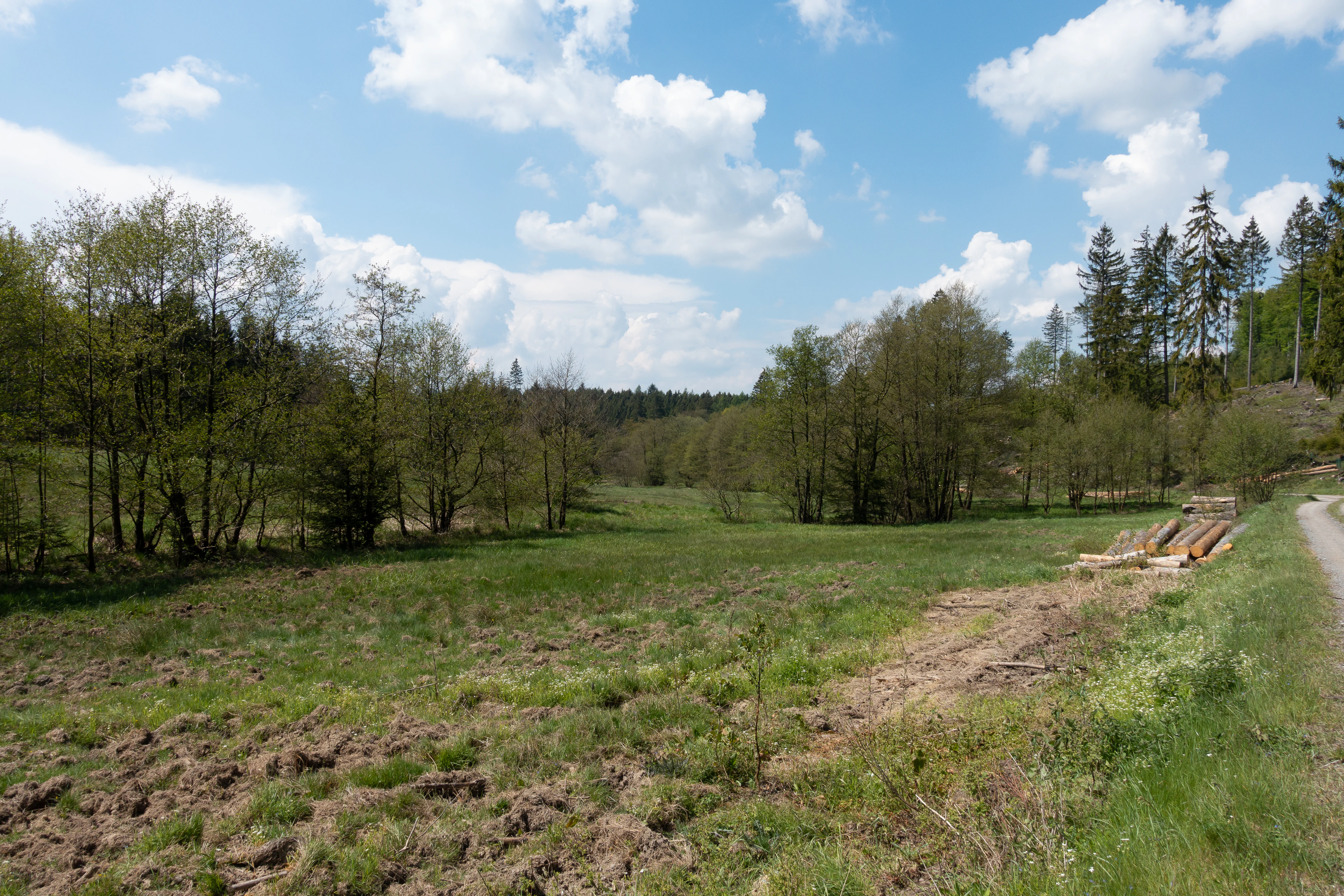
A wide, grassy clearing or meadow surrounded by a mixed forest, with a gravel path visible on the right and stacked logs resting near the tree line.
A grassy meadow bordered by trees in the Landschaftsschutzgebiet FFH-Gebiet Fürstenberger Wald.

Landschaftsschutzgebiet FFH-Gebiet Fürstenberger Wald history and protected-area timeline

The protected landscape was formally designated in 2007 when the Kreistag of Kreis Paderborn adopted the landscape plan Büren-Wünnenberg, which established the Landschaftsschutzgebiet on the Fürstenberger Wald. Although the LSG designation is recent in administrative terms, the forest itself had already gained a higher tier of ecological recognition in 2004, when it became part of the European Habitats Directive site known as Bredelar, Stadtwald Marsberg und Fürstenberger Wald, registered under the code DE 4518-305.

A notable element of the area's modern history is a 2001 conservation agreement covering parts of the landscape that are privately owned by the Counts of Westphalen. The agreement was concluded to secure protection and continued care of these forest parcels and reflects an early effort to integrate private forest ownership into the broader conservation framework.

The forest also contains older cultural traces, including a former glassworks site. Small wood-burning glass and iron operations were once characteristic of densely forested upland regions in Westphalia, and their former locations are part of the broader industrial-archaeological character of the eastern Sauerland foothills.

Landschaftsschutzgebiet FFH-Gebiet Fürstenberger Wald landscape and geographic character

The landscape is a gently sculpted upland forest plateau typical of the eastern Sauerland foothills, with shallow valleys cut by small brooks that originate in numerous springs within the woodland. The terrain favors a mosaic of closed forest cover broken by narrow, ribbon-like openings along the streams, where moist meadows and tall-herb vegetation follow the watercourses.

The ground surface is shaped by the underlying geology of the region, which supports acidic to moderately acidic soils favorable for beech woodland and oak mixtures. The valleys carry a distinctive pattern of permanently moist soils, floodplain soils along the brooks, and isolated pockets of peaty, waterlogged ground that support boggy woodland communities. Small historic water features, such as the Stauteich of the Kleine Aa, reflect past human attempts to use these water resources and remain embedded in the present-day landscape.
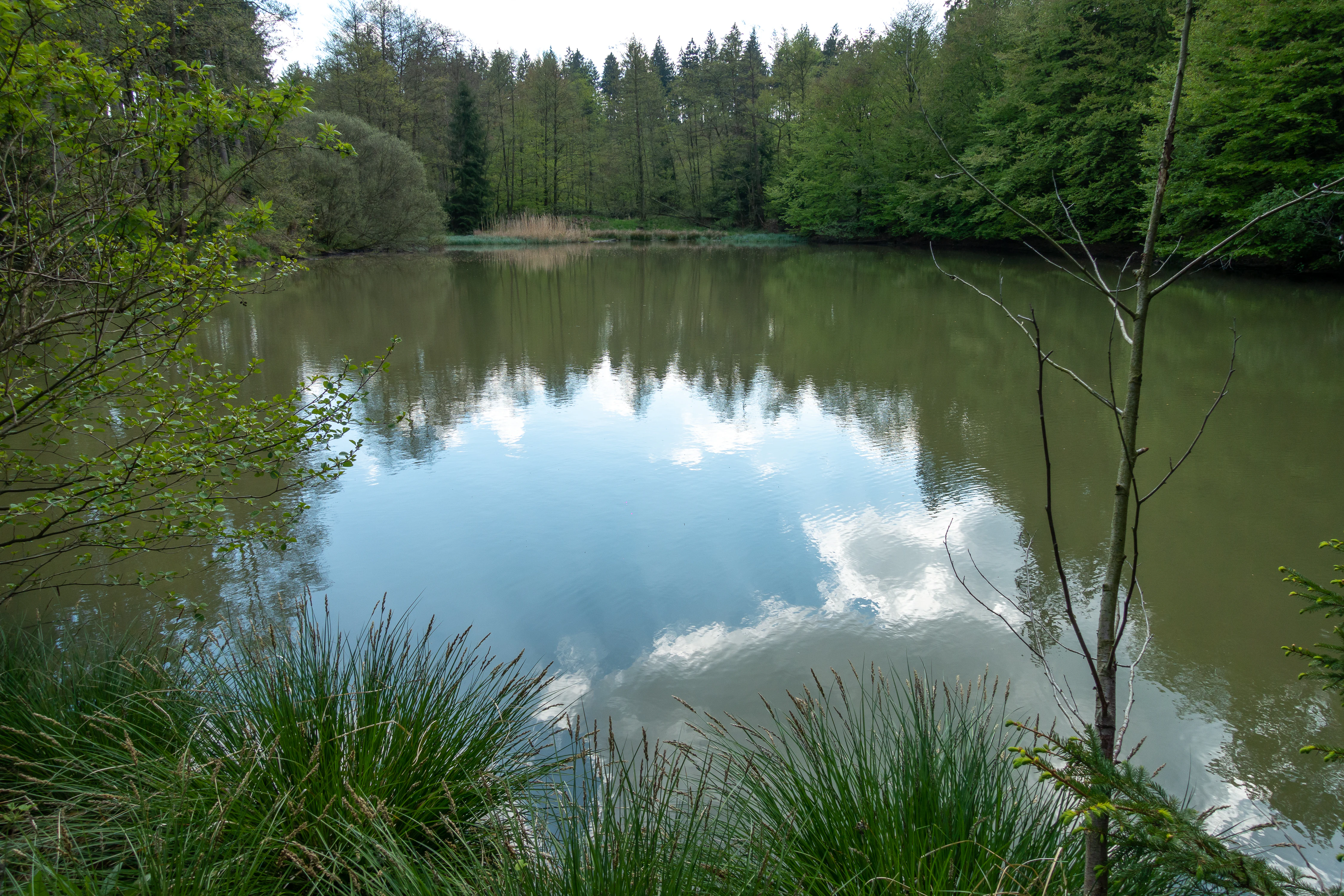
A calm pond surrounded by dense green forest, reflecting the sky and surrounding trees.
A calm pond along the Kleine Aa river within the Fürstenberger Wald protected area.

Landschaftsschutzgebiet FFH-Gebiet Fürstenberger Wald ecosystems, habitats, and plant life

Ecologically, the area is dominated by Hainsimsen beech forest, a community known for its high share of old trees, abundant deadwood, and structural age variation. These characteristics give the forest an unusually pronounced habitat quality for woodland species that depend on continuity and decay processes. Within this framework, oak-mixed forests, spruce stands, alder-ash gallery forests, and true bog forests collectively create a forest mosaic that varies along moisture and soil gradients.

The streams and their associated valleys add a second ecological layer. Springs emerge across the forest and feed near-natural brooks with intact underwater vegetation. The banks and adjacent grasslands host tall-herb communities, sedge-dominated vegetation, and moist meadows that collectively form a small but well-developed network of open wetland habitats within an otherwise forested setting. The vertical structure of this landscape, with closed canopy, layered understory, deadwood, fallen leaves, springs, and stream-side openings, supports a wide ecological gradient within a relatively compact protected area.

Landschaftsschutzgebiet FFH-Gebiet Fürstenberger Wald wildlife and species highlights

The Fürstenberger Wald is particularly significant for its forest birdlife. The landscape plan explicitly identifies the area as a breeding and foraging habitat for the black stork, a species that depends on quiet, structurally diverse forests with nearby wet feeding grounds. The same plan highlights a nearly complete forest avifauna of state-level importance, with additional sensitive species such as the black woodpecker, grey-headed woodpecker, middle spotted woodpecker, Eurasian pygmy owl, and red kite mentioned in connection with disturbance regulation around breeding sites.

Beyond the birds, the deadwood-rich beech forests and spring networks support a rich community of woodland invertebrates, fungi, and bryophytes typical of mature central European broadleaf forests. The boggy woodland patches and wet meadows provide additional habitat value for amphibians, dragonflies, and other moisture-dependent fauna, while the stream-side gallery forests and their understory serve as ecological corridors for small mammals and other forest species.

Landschaftsschutzgebiet FFH-Gebiet Fürstenberger Wald conservation status and protection priorities

The Fürstenberger Wald carries a layered conservation status. As a Landschaftsschutzgebiet under the landscape plan Büren-Wünnenberg, it receives general landscape protection at the district level, while the FFH designation brings European-level recognition under the Habitats Directive and obliges member states to maintain favorable conservation status for the habitats and species involved.

The landscape plan identifies several explicit objectives. In the medium term, conifer stands are to be converted into site-appropriate deciduous forest, and the agricultural land within the protected area is to be managed extensively as meadow, mowed pasture, or pasture. Reforestation is restricted to clearly defined areas and limited to native deciduous tree species. Limited admixture of conifers, up to roughly twenty percent, is permitted in Hainsimsen beech forest outside of spring zones and small valley depressions known as Siepen, but only in small groups or as scattered individual trees.

During the breeding season of sensitive species such as the black stork, black woodpecker, grey-headed woodpecker, middle spotted woodpecker, pygmy owl, and red kite, disruptive activities in the vicinity of nesting sites are to be avoided. Bituminous paths are to be progressively removed, especially in areas of legally protected habitats, Siepen, and wet zones, in order to reduce hydrogeological disruption and ecological fragmentation. The 2001 conservation agreement with the Counts of Westphalen adds a private-forest dimension to the conservation framework, illustrating cooperation with traditional landholding structures.

In the words of the landscape plan, the area is considered to be of state-level significance for its size, its network of source brooks and near-natural streams with their gallery forests, and its nearly complete forest bird community, functioning as a key refugium and connecting element in the wider forest landscape.

Landschaftsschutzgebiet FFH-Gebiet Fürstenberger Wald cultural meaning and human context

The Fürstenberger Wald reflects a long history of interaction between forest and human activity typical of the Westphalian uplands. The remaining traces of a former glassworks illustrate the era when forested hill country supported wood-fueled industries such as small glassworks and ironworks, which disappeared as the forests were depleted or industrial economies shifted elsewhere.

The Counts of Westphalen, who still hold private forest within the protected area, form part of the regional aristocratic and landed heritage that has shaped forest ownership patterns in this part of Germany for centuries. The 2001 conservation agreement with the family represents a modern expression of this long-standing relationship between landowner and landscape. The area is also catalogued as a regionally significant cultural landscape, the Wünnenberger and Fürstenberger Wald, recognized for its combined natural and historical character.

Top sights and standout views in Landschaftsschutzgebiet FFH-Gebiet Fürstenberger Wald

Among the most notable features of the Fürstenberger Wald are its large, contiguous Hainsimsen beech forests with abundant old trees and deadwood, and its dense network of near-natural springs and brooks that feed wet meadows and rich stream-side vegetation. The area is recognized at the state level for its forest bird community and functions as important breeding and foraging habitat for the black stork.

The protected landscape is also distinctive for the convergence of protection instruments that apply to it: a regional landscape protection designation, a European Habitats Directive designation, a private-landowner conservation agreement, and active management aimed at converting conifer forests into native deciduous woodland. The combination of ecological coherence, hydrological richness, and layered protection makes it a notable reference area for forest conservation in the eastern Sauerland foothills.

Best time to visit Landschaftsschutzgebiet FFH-Gebiet Fürstenberger Wald

Spring and early summer tend to be the most rewarding periods for visiting the Fürstenberger Wald, when the deciduous canopy is light enough to allow observation of woodland birds such as the black stork and various woodpeckers, and when the stream-side vegetation and meadows show their richest ground-layer development. Late spring also coincides with the most sensitive breeding season for several protected species, so visitors should remain on trails and avoid disturbance near known nesting areas.

Late summer and autumn bring different qualities, with mushroom communities in the beech forest and quieter wildlife observation conditions as the bird breeding season fades. Winter visits emphasize the structural character of the forest, when old trees, deadwood features, and the small valley brooks can be appreciated without heavy foliage.


Monthly climate preview

Long-term representative temperature and precipitation averages across twelve recorded monthly cycles

Landschaftsschutzgebiet FFH-Gebiet Fürstenberger Wald Climate Normals and Annual Weather Patterns

Historical monitoring data from NASA Power reveals measured annual temperature fluctuations and daily precipitation rates recorded across representative coordinates within Landschaftsschutzgebiet FFH-Gebiet Fürstenberger Wald. Examining the comprehensive monthly climate profile provides deeper context on long-term thermal rhythms and moisture distribution patterns.
Annual mean9 °C
0 °C18 °C
Jan
Feb
Mar
Apr
May12°
Jun15°
Jul18°
Aug18°
Sep14°
Oct
Nov
Dec
Warmest month
July

18 °C

Coolest month
January

-0.2 °C

Wettest month
July

2.6 mm/day

Driest month
April

1.7 mm/day

Park location guide

Geography guide, regional context, and park location map for Landschaftsschutzgebiet FFH-Gebiet Fürstenberger Wald

Landschaftsschutzgebiet FFH-Gebiet Fürstenberger Wald park geography, regions, and map view in Germany

Understand where Landschaftsschutzgebiet FFH-Gebiet Fürstenberger Wald sits in Germany through a broader geographic reading of the surrounding landscape, nearby location context, and its mapped position within the national park landscape.

How Landschaftsschutzgebiet FFH-Gebiet Fürstenberger Wald fits into Germany

Germany is a federal republic in Western and Central Europe with a population of over 83 million across sixteen constituent states. It is Europe's largest economy by nominal GDP and a major global exporter and importer. The capital is Berlin, and the country borders Denmark, Poland, Czech Republic, Austria, Switzerland, France, Luxembourg, Belgium, and the Netherlands.

Wider geography shaping Landschaftsschutzgebiet FFH-Gebiet Fürstenberger Wald in Germany

Germany is located in Western and Central Europe, spanning 357,022 km². It borders Denmark to the north, Poland and the Czech Republic to the east, Austria and Switzerland to the south, and France, Luxembourg, Belgium, and the Netherlands to the west. The country has coastlines on the Baltic Sea and North Sea to the north, with the Alps located in the southern region.

Map view of Landschaftsschutzgebiet FFH-Gebiet Fürstenberger Wald

Use this park location map to pinpoint Landschaftsschutzgebiet FFH-Gebiet Fürstenberger Wald in Germany, understand its exact geographic position, and read its mapped placement within the surrounding landscape more clearly.

Pigeon | © OpenStreetMap contributors

Location context for Landschaftsschutzgebiet FFH-Gebiet Fürstenberger Wald

Kreis Paderborn

Visual exploration of old-growth beech forests, spring networks, and protected valley habitats.

Landschaftsschutzgebiet FFH-Gebiet Fürstenberger Wald Photos, Scenery, and Landscapes

Visual records illustrate the dense network of old-growth beech stands, winding forest brooks, and wet valley meadows that characterize the protected terrain. Examining these detailed landscapes provides deeper insight into the ecological structure and natural topography of the regional forest reserve.

A wide, grassy clearing or meadow surrounded by a mixed forest, with a gravel path visible on the right and stacked logs resting near the tree line.

A still pond reflecting a historic building with a red tile roof and surrounding deciduous trees and forest under a partly cloudy sky.

A calm pond surrounded by dense green forest, reflecting the sky and surrounding trees.

Park atlas

Compare adjacent protected landscapes and surrounding regional forest ecosystems

Other Parks Near Landschaftsschutzgebiet FFH-Gebiet Fürstenberger Wald

Browsing other protected areas near Landschaftsschutzgebiet FFH-Gebiet Fürstenberger Wald reveals broader regional forest ecosystems and connected valley habitats. Comparing adjacent woodland preserves provides deeper context on upland terrain and regional conservation patterns across the eastern Sauerland foothills.
A horizontal watercolor illustration of a soft, hazy valley with rolling green hills, distant treelines, and wildflowers in the foreground.
Nature reserveNorth Rhine-Westphalia
About 3.4 km away#1 closest

Southwest

Naturschutzgebiet Aabachtal Nature Reserve and Sauerland Protected Stream Valley Geography

A preserved fluvial landscape in North Rhine-Westphalia

Naturschutzgebiet Aabachtal is a protected nature reserve in the northern Sauerland of North Rhine-Westphalia. Centered on the Aabach stream, it protects a classic Mittelgebirge valley landscape defined by meandering watercourses, lush floodplain meadows, and deciduous forest slopes, serving as a critical habitat for specialized moisture-loving flora and diverse riparian fauna.

Area
0.716 km²
Established
2001
Relief
Upland
Scope
Terrestrial
A horizontal watercolor painting showing rolling, abstract hills with patches of green, yellow, and soft red, accented with stylized coniferous forest lines.
Nature reserveNordrhein-Westfalen
About 4.7 km away#2 closest

West

Leiberger Wald Nature Reserve: Protected Woodland and Stream Geography in Paderborn

A mapped forest complex within the Nordrhein-Westfalen landscape

Leiberger Wald encompasses an extensive series of beech forests and riparian habitats that form a key protected node in the Kreis Paderborn. As a significant nature reserve, the area supports a wide range of woodland and aquatic species, serving as a critical refuge within the broader ecological network of western Germany.

Area
17.86 km²
Established
1994
IUCN
IV
Watercolor painting of a wide, soft-toned landscape showing gentle rolling hills, open fields, and a small meandering stream, executed in a minimalist, light-filled style.
Protected landscapeHochsauerlandkreis
About 7.4 km away#3 closest

Southeast

Landschaftsschutzgebiet Freiflächen um Giershagen: Protected Landscape and Regional Map

Agricultural cultural heritage and biodiversity in Hochsauerlandkreis

This protected area in North Rhine-Westphalia preserves 785 hectares of traditional Sauerland countryside. It features extensively managed farmland, rare arable plant habitats, and historically significant landscape structures that support regional biodiversity and long-term ecological stewardship.

Area
7.849 km²
Established
2008
Relief
Upland
Scope
Terrestrial
A watercolor landscape illustration showing soft, rolling green hills, coniferous trees, and a hazy background.
Nature reserveHochsauerlandkreis
About 8 km away#4 closest

South

Naturschutzgebiet Padberg: A Protected Landscape in the Hochsauerlandkreis Region

Diabas geology and forest habitat mapping

Naturschutzgebiet Padberg protects a compact but ecologically rich landscape of beech forests and craggy rock cliffs. Its position above the Diemel valley highlights the relationship between volcanic Diabas topography and woodland development within the Hochsauerlandkreis district.

Area
0.467 km²
Established
2001
Relief
Upland
Climate
Temperate
A soft watercolor illustration showing a gentle, rolling landscape with green meadows, trees, and distant hills under a pale sky.
Nature reserveHochsauerlandkreis
About 8.8 km away#5 closest

South

Naturschutzgebiet Östlicher Arnstein: Protected Nature Reserve and Geographic Map

Grassland mosaic and historic terrain in Hochsauerlandkreis

Naturschutzgebiet Östlicher Arnstein comprises 8.5 hectares of species-rich meadows and hedgerow complexes nestled in the Waldecker Gefilde. This reserve offers a significant look at regional grassland conservation, providing habitat diversity through its base-rich soils and disused quarry sites. It acts as a vital transition point between the forested Sauerland slopes and the surrounding open agricultural landscape.

Area
0.085 km²
Established
2001
Relief
Lowland
Climate
Temperate
A soft watercolor illustration of rolling green hills, a cluster of trees, and distant low mountains in muted pastel tones.
Protected landscapeHochsauerlandkreis
About 9 km away#6 closest

Southeast

Landschaftsschutzgebiet Freiflächen um Erlinghausen / Auf der Sandkuhle: Protected Area Map

A regional landscape conservation zone in Hochsauerlandkreis

This protected landscape encompasses 548 hectares of rural terrain surrounding Erlinghausen. It is defined by its traditional agricultural matrix, orchard meadows, and cultural heritage features that maintain the historic character of the eastern Sauerland foothills.

Area
5.487 km²
Established
2008
Relief
Upland
Scope
Terrestrial
A soft watercolor painting showing a panoramic view of rolling hills and undulating green and pink landscape features against a pale sky.
Nature reserveWaldeck-Frankenberg
About 9.3 km away#7 closest

East

Naturschutzgebiet Büchenberg und Platzberg bei Hesperinghausen: Geography and Protected Landscapes

A study of limestone slopes and calcareous grassland habitats

This protected area in Waldeck-Frankenberg serves as a key site for calcareous dry grasslands and rare orchid species. The terrain features a striking mosaic of steep Zechstein limestone slopes, rock outcrops, and moisture-rich meadow patches. Analyzing the area reveals how small, traditionally managed reserves can maintain high biodiversity and provide essential connectivity within the Diemeltal regional landscape.

Area
0.418 km²
Established
1993
Relief
Upland
Climate
Temperate
A soft watercolor illustration of a landscape featuring layered green hills, a distant forest silhouette, and pale sky, rendered in a light, minimalist style.
Nature reserveHochsauerlandkreis
About 9.4 km away#8 closest

South

Naturschutzgebiet Oberes Diemeltal: Protected Floodplain and River Geography in Hochsauerlandkreis

Mapped riparian landscapes and riverine conservation corridors

Naturschutzgebiet Oberes Diemeltal preserves an undeveloped section of the upper Diemel river valley. The landscape is defined by its branching river network, wet meadows, and rare floodplain vegetation, offering a clear window into the riverine geography of the eastern Sauerland region in Germany.

Area
1.87 km²
Established
2001
Scope
Terrestrial
Water
Major water bodies

Common questions about visiting, size, designation, and location context for Landschaftsschutzgebiet FFH-Gebiet Fürstenberger Wald

Landschaftsschutzgebiet FFH-Gebiet Fürstenberger Wald FAQs for park facts, access, geography, and protected area context

Find quick answers about Landschaftsschutzgebiet FFH-Gebiet Fürstenberger Wald, including protected-area facts, park geography, trail and visitor context, and how the park fits into its surrounding country and regional landscape.
MoriAtlas Explorer

Continue Your Protected Areas Search Across the Global Atlas

Deepen your exploration by continuing the structured search for national parks and protected areas worldwide. Utilize the comprehensive filtering capabilities to compare different conservation landscapes and refine your understanding of global park geography. Discover more about the distribution and characteristics of protected natural areas.

Global natural geography