
Mori Atlas logo
Protected landscapeLandschaftsschutzgebiet Freiflächen um Giershagen

Mapping the agricultural terrain, biodiversity corridors, and cultural landscape character in Hochsauerlandkreis.

Landschaftsschutzgebiet Freiflächen um Giershagen: Regional Protected Landscape Geography

Landschaftsschutzgebiet Freiflächen um Giershagen covers roughly 785 hectares of open countryside within the Marsberg municipal area. This protected zone preserves a traditional Sauerland cultural landscape characterized by interconnected meadows, pastures, and rare arable plant habitats. The terrain serves as a vital ecological buffer and biodiversity site, linking rural farmland with the broader natural networks of the Diemel and Hoppecke valleys.

landscape protection areaagricultural landscapeopen countrysidecultural landscapeSauerlandfarmland biodiversity
A flat-style digital illustration depicting a mountain valley with a waterfall flowing between cliffs, surrounded by a coniferous forest, green slopes, and tall grasses.

Landschaftsschutzgebiet Freiflächen um Giershagen

Protected landscape

Park overview

Structured park overview, official facts, and landscape profile for Landschaftsschutzgebiet Freiflächen um Giershagen

Landschaftsschutzgebiet Freiflächen um Giershagen park facts, protected area profile, and essential visitor context

Review the core facts for Landschaftsschutzgebiet Freiflächen um Giershagen, including designation, size, terrain, visitor scale, habitats, and operating context in one park-focused overview.

About Landschaftsschutzgebiet Freiflächen um Giershagen

Landschaftsschutzgebiet Freiflächen um Giershagen is a landscape protection area in the eastern Sauerland that reflects the regional approach of safeguarding open countryside around rural settlements rather than establishing a purely nature-focused reserve. The roughly 785-hectare zone surrounds the village of Giershagen within the city of Marsberg and forms part of a broader mosaic of designated landscape areas in the Hochsauerlandkreis. Its designation in 2008 followed the adoption of the Marsberg landscape plan, an instrument used by the district to coordinate land use, conservation, and recreation across the municipal territory.

The area falls into the Type B category of protected landscapes in North Rhine-Westphalia, a class that specifically targets settlement-edge locations, open land, and cultural landscape protection. As a result, the landscape character is shaped by a mixture of farmland, meadows, and traditional rural features rather than by wilderness or large forests. The open agricultural setting gives the area both its scenic identity and its principal conservation value, since the maintenance of these landscapes depends on continued farming and careful land management.

Although the area includes agricultural land of relatively ordinary appearance, it carries ecological weight through its connection to larger protected networks. The protected landscape component Feldgehölz im Schlage lies within the boundaries, and since 2023 a VNV-owned farmland parcel in the Schlage area has also been part of the Vogelschutzgebiet Diemel- und Hoppecketal, a Special Protection Area under the European Union Birds Directive. This linkage connects the cultural landscape to broader efforts to protect birdlife in the Diemel and Hoppecke valley region. Mining relics along the southern margin add a small but visible historical feature to the otherwise agricultural setting.

The site's growing reputation rests on the intensive stewardship work led by the Verein für Natur- und Vogelschutz im Hochsauerlandkreis. Long-term leases, targeted land purchases, and carefully designed extensive farming practices have produced meaningful conservation outcomes on what would otherwise be ordinary farmland, making Freiflächen um Giershagen an instructive example of how local associations can shape biodiversity outcomes within modest protected landscape areas.

Quick facts and research context for Landschaftsschutzgebiet Freiflächen um Giershagen

Landschaftsschutzgebiet Freiflächen um Giershagen covers approximately 785 hectares surrounding the village of Giershagen within the city of Marsberg. It is one of the landscape protection areas established through the 2008 Marsberg landscape plan by the Hochsauerlandkreis district council and is classified as a Type B area, focused on preserving settlement-edge open land and cultural landscapes. A protected landscape component, the Feldgehölz im Schlage field grove, lies within the area, and since 2023 a farmland parcel owned by the local nature association has also been part of the Diemel and Hoppecke valleys bird protection area.

Protection and recognition

Examine the documented terrestrial protection status and management scope for this protected area.

Landschaftsschutzgebiet Freiflächen um Giershagen Protection Status and Recognition

Terrestrial protection status and designation details provide structured context for Landschaftsschutzgebiet Freiflächen um Giershagen. Verified records outline the documented management scope without assuming international recognition programs.

Protection details

Protection scope
Terrestrial
Park context

Deeper park guide and search-rich context for Landschaftsschutzgebiet Freiflächen um Giershagen

Landschaftsschutzgebiet Freiflächen um Giershagen history, landscape, wildlife, and travel context

Explore Landschaftsschutzgebiet Freiflächen um Giershagen through its history, landscape character, ecosystems, wildlife, conservation priorities, cultural context, and seasonal travel timing in a structured park guide built for atlas discovery and search intent.

Why Landschaftsschutzgebiet Freiflächen um Giershagen stands out

The area is best known for its role as a buffer of traditional open countryside around the village of Giershagen and for the conservation work carried out in the Schlage area, where purchased farmland has been managed extensively to support rare arable wild plants. One of these fields was recognized by the German Federal Environmental Foundation in 2021 as one of the 100 fields for biodiversity, highlighting a rediscovery of a species once considered extinct in the region.
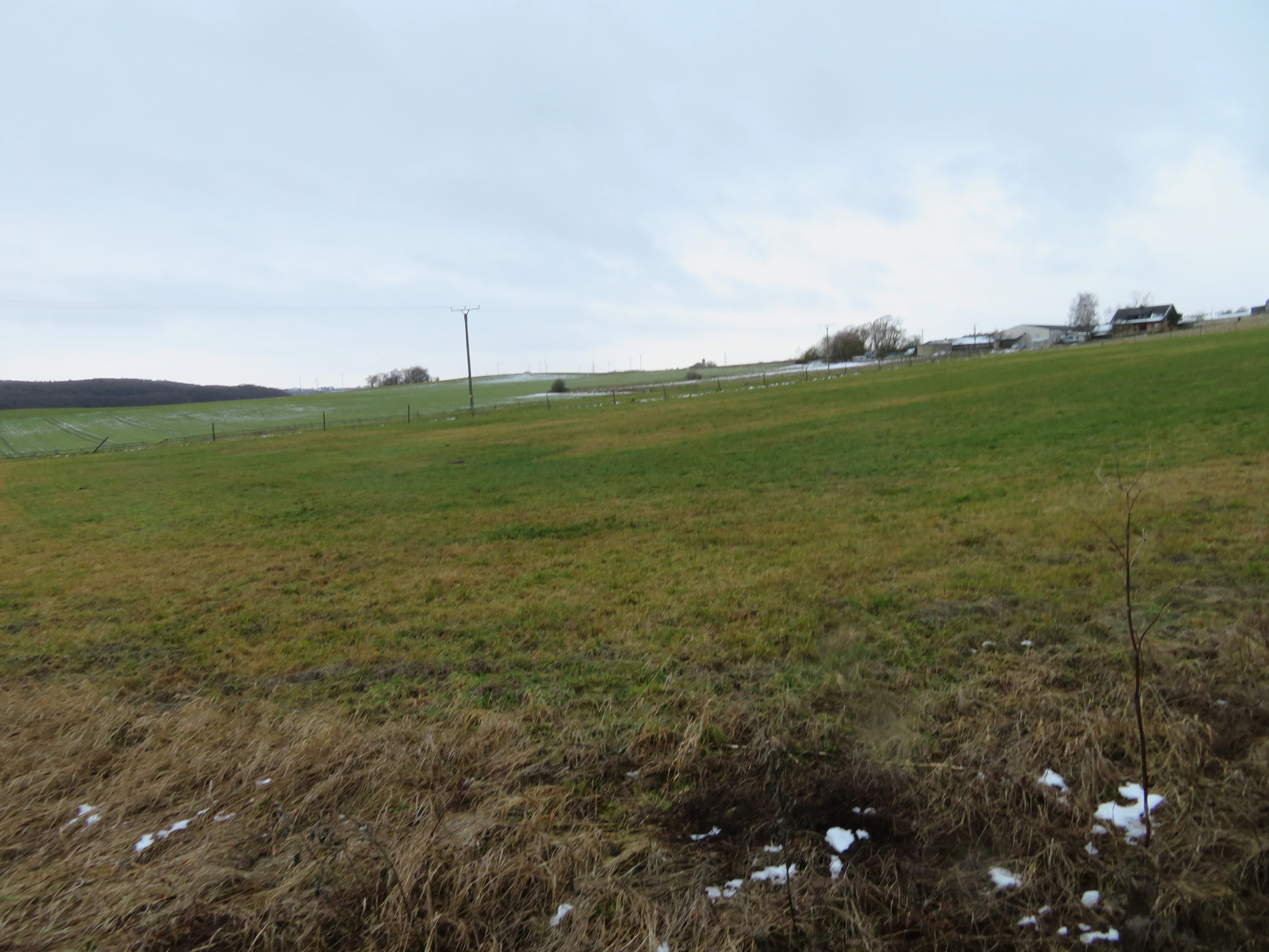
A wide angle view of an open green field in a rural landscape under a cloudy sky, with scattered patches of snow on the ground and buildings visible in the distance.
View of the open agricultural landscape within the Freiflächen um Giershagen protected area.

Landschaftsschutzgebiet Freiflächen um Giershagen history and protected-area timeline

The area was formally designated as a landscape protection area in 2008, when the Marsberg landscape plan was adopted by the district council of the Hochsauerlandkreis. Its establishment positioned the zone within a larger regional framework for managing open landscapes, settlement edges, and culturally shaped countryside across the district. From the beginning, the area was placed in the Type B protection category, which in North Rhine-Westphalia specifically addresses rural open land near villages and historical agricultural priority zones.

Long before formal designation, conservation work had already begun in the Schlage section of what would later become part of the protected area. The Verein für Natur- und Vogelschutz im Hochsauerlandkreis began restoration work around the Giershagen lime kiln in 1986, removing illegal dumped waste from a former quarry during volunteer working weekends. From the mid-1990s, the association began mowing dry grassland sections, and over subsequent decades volunteers cleared encroaching hazel shrubs and aspens that were threatening the open character of the site. The association first leased the lime kiln area in 1986 and ultimately purchased it in 2013, securing long-term stewardship.

Beginning in 2013, the VNV acquired additional farmland north of the lime kiln and outside the neighboring Glindetal nature reserve to expand its conservation efforts. In 2015, these fields were managed under a new farmland margin strip arrangement, with reduced fertilization, no pesticide use, and wider sowing spacing. A first winter cereal sowing in autumn 2018 marked a turning point, and by 2019 surveys documented more than fifty species of arable wild plants, including extremely rare species such as summer pheasant's eye and corn chamomile, as well as the round-leaved hare's ear, which had previously been believed extinct in the region. In 2021 the Deutsche Bundesstiftung Umwelt honored one of these fields as one of the 100 fields for biodiversity, recognizing the combination of high species richness, permanent land security through purchase, and ongoing species monitoring. By 2024 the population of arable wild plants had developed strongly, with numerous Red List species present.

Landschaftsschutzgebiet Freiflächen um Giershagen landscape and geographic character

The landscape of Freiflächen um Giershagen is defined by gently rolling agricultural countryside typical of the eastern Sauerland. The protected area encircles the village of Giershagen and extends roughly northward toward Obermarsberg, creating a broad zone of open farmland between and around the rural settlements of the Marsberg municipal area. Fields, meadows, and pastures dominate the view, giving the area an open, light-suffused character that contrasts with the more forested parts of the Hochsauerlandkreis further south.

Small landscape features add variety to this primarily agricultural canvas. Hedges, field groves, and the protected Feldgehölz im Schlage break up the expanse of open land, providing both visual structure and habitat patches within the farmed zone. In the southern part of the area, mining relics of historical extraction remain visible, offering a reminder of the long-standing human impact on the landscape and creating pockets of unusual ground conditions among the surrounding farmland.

While the topography is generally moderate, the combination of fields, meadows, and small natural structures produces a landscape of subtle but legible variation. The openness supports long views across the surrounding countryside, while the proximity to forest edges, villages, and the broader Diemel-Hoppecke valley system links this seemingly ordinary farmland to a wider regional landscape context.

Landschaftsschutzgebiet Freiflächen um Giershagen ecosystems, habitats, and plant life

Ecologically, the area is shaped less by dramatic habitat diversity and more by the careful maintenance of traditional open land. Agricultural fields and meadows represent the dominant habitats, and their continued open character is one of the primary conservation goals. The presence of arable wild plant communities, particularly on the specially managed VNV fields, gives the area an ecological significance far beyond what its visually ordinary farmland would suggest. The protected Feldgehölz im Schlage provides a small wooded contrast within the otherwise open setting.

The Schlage section in particular has become a focal point for rare arable flora. Extensive management, including the absence of fertilizers and pesticides, reduced sowing density, and wider row spacing, has produced habitats where classic farmland wildflowers can survive alongside cropped cereals. These habitats support species once common across German farmland but now increasingly restricted to extensively managed pockets. The inclusion of part of the area in the Diemel and Hoppecke valleys bird protection zone from 2023 further strengthens the ecological role of the broader landscape.

The result is a habitat mosaic that depends on continued human stewardship rather than on ecological isolation. The mix of regularly farmed land, specialty fields with reduced inputs, dry grassland near the former lime kiln quarry, and small woody features creates a working landscape in which ecological value and agricultural use are deliberately balanced.

Landschaftsschutzgebiet Freiflächen um Giershagen wildlife and species highlights

The wildlife profile of the area is closely tied to open farmland and to the regional bird protection area that overlaps part of it. Since 2023, the Schlage farmland parcel has been part of the Vogelschutzgebiet Diemel- und Hoppecketal mit angrenzenden Wäldern, linking the cultural landscape to a broader network of habitats important for European bird populations. Open meadows, field margins, and the small field grove provide habitat structure that supports typical open-country bird species of the Sauerland region.

Botanically, the area has gained considerable attention because of its exceptionally rich arable wild plant communities. The VNV-managed fields have hosted species rarely seen in modern German farmland, including the summer pheasant's eye, corn chamomile, and the round-leared hare's ear, a species whose rediscovery in the region was a notable conservation event. Dry grassland species also persist around the former lime kiln, where volunteer mowing has preserved open conditions for decades.

Although the site is not characterized by large mammals or charismatic megafauna, the combination of small field groves, extensively managed farmland margins, residual dry grassland, and adjoining valley forests gives the broader landscape value for invertebrates, smaller mammals, and typical farmland birdlife. The site's ecological significance comes as much from the presence of rare plants as from any individual animal species.

Landschaftsschutzgebiet Freiflächen um Giershagen conservation status and protection priorities

From a conservation perspective, Freiflächen um Giershagen illustrates how a relatively modest landscape protection area can achieve outsized biodiversity results through targeted local stewardship. The area was designated to maintain the diversity and character of the landscape near settlements and historical agricultural zones, keep the land open, and preserve its value for recreation. These goals reflect the typical role of Type B protected landscapes in North Rhine-Westphalia, where the objective is to safeguard working cultural landscapes rather than to create strict nature reserves.

The most striking conservation outcomes are concentrated in the Schlage area, where the Verein für Natur- und Vogelschutz im Hochsauerlandkreis has pursued a long-term strategy combining land purchase, extensive farming arrangements, and active habitat management. The deliberate reduction of agricultural inputs on purchased fields has allowed rare arable wild plants to recover, and in 2021 the Deutsche Bundesstiftung Umwelt recognized one of these fields as one of the 100 fields for biodiversity in Germany. The award required both high species richness and a permanent mechanism for land security, which the VNV's purchase of the parcels provided.

The integration of VNV-owned farmland into the Diemel and Hoppecke valleys bird protection area in 2023 further formalizes the conservation importance of the zone, connecting it to the European network of protected sites designated under the Birds Directive. Together, these elements show how a landscape protection area can serve as a bridge between everyday agriculture, local volunteer conservation, and broader European ecological policy frameworks.

Landschaftsschutzgebiet Freiflächen um Giershagen cultural meaning and human context

The protected area reflects the long-standing cultural relationship between the villages of the eastern Sauerland and their surrounding farmland. The pattern of settlements, fields, meadows, and forest edges preserved within the area represents the traditional rural economy of the Hochsauerlandkreis, where small farming communities have shaped the landscape over centuries. Maintaining this cultural landscape is an explicit goal of the area's Type B designation, which prioritizes the openness and identity of historic agricultural zones.

Mining relics along the southern edge of the area add a more specific local heritage dimension. These remnants document the historical extraction activity that once shaped parts of the Sauerland's economy and landscape, providing visible evidence of the region's industrial past within an otherwise agricultural setting. The presence of historical features such as the Giershagen lime kiln, whose surroundings have been actively conserved since the 1980s, further anchors the area in local cultural memory.

The strong role of the Verein für Natur- und Vogelschutz im Hochsauerlandkreis also reflects a regional tradition of volunteer-based nature and bird conservation. The association's decades-long presence on the ground, working with farmers and landowners to balance cultivation and biodiversity, is itself part of the cultural fabric of the Hochsauerlandkreis and shapes the modern identity of this protected landscape.

Top sights and standout views in Landschaftsschutzgebiet Freiflächen um Giershagen

A working agricultural landscape of roughly 785 hectares around the village of Giershagen, preserved under a 2008 landscape plan to maintain the openness and character of traditional Sauerland countryside. The area's standout distinction is the Schlage section, where purchased fields under extensive management have revived an extraordinary diversity of arable wild plants, including a species previously thought extinct in the region. The 2021 recognition of a VNV-managed field as one of Germany's 100 fields for biodiversity and the 2023 inclusion of part of the area in a larger bird protection zone underline the conservation significance of this otherwise unassuming farmland setting.

Best time to visit Landschaftsschutzgebiet Freiflächen um Giershagen

The landscape is accessible year-round and reflects the seasonal rhythm of an agricultural countryside. Late spring and summer bring the most vivid expression of the area's flora, when meadow plants, field edges, and dry grassland sections around the former lime kiln show their full botanical character. Late summer and early autumn coincide with cereal harvest activity on the cultivated fields, including the specially managed Schlage parcels, while winter reveals the openness of the landscape and its long views across the rolling farmland. Activities such as walking and observing the rural landscape can be combined with visits to nearby Giershagen and the surrounding villages of the Marsberg area.

Monthly climate preview

Long-term representative climate patterns and monthly averages across the protected area coordinate

Annual Temperature and Precipitation Normals for Landschaftsschutzgebiet Freiflächen um Giershagen

Representative coordinate records show measured monthly temperature variations spanning sub-zero winter minimums to warm summer maximums alongside consistent daily precipitation amounts. Detailed twelve-month climate normals provide a complete analytical profile of the annual thermal and moisture rhythm across the protected landscape.
Annual mean9 °C
0 °C18 °C
Jan
Feb
Mar
Apr
May12°
Jun15°
Jul18°
Aug18°
Sep14°
Oct
Nov
Dec
Warmest month
July

18 °C

Coolest month
January

-0.2 °C

Wettest month
July

2.6 mm/day

Driest month
April

1.7 mm/day

Park location guide

Geography guide, regional context, and park location map for Landschaftsschutzgebiet Freiflächen um Giershagen

Landschaftsschutzgebiet Freiflächen um Giershagen park geography, regions, and map view in Germany

Understand where Landschaftsschutzgebiet Freiflächen um Giershagen sits in Germany through a broader geographic reading of the surrounding landscape, nearby location context, and its mapped position within the national park landscape.

How Landschaftsschutzgebiet Freiflächen um Giershagen fits into Germany

Germany is a federal republic in Western and Central Europe with a population of over 83 million across sixteen constituent states. It is Europe's largest economy by nominal GDP and a major global exporter and importer. The capital is Berlin, and the country borders Denmark, Poland, Czech Republic, Austria, Switzerland, France, Luxembourg, Belgium, and the Netherlands.

Wider geography shaping Landschaftsschutzgebiet Freiflächen um Giershagen in Germany

Germany is located in Western and Central Europe, spanning 357,022 km². It borders Denmark to the north, Poland and the Czech Republic to the east, Austria and Switzerland to the south, and France, Luxembourg, Belgium, and the Netherlands to the west. The country has coastlines on the Baltic Sea and North Sea to the north, with the Alps located in the southern region.

Map view of Landschaftsschutzgebiet Freiflächen um Giershagen

Use this park location map to pinpoint Landschaftsschutzgebiet Freiflächen um Giershagen in Germany, understand its exact geographic position, and read its mapped placement within the surrounding landscape more clearly.

Pigeon | © OpenStreetMap contributors

Location context for Landschaftsschutzgebiet Freiflächen um Giershagen

Hochsauerlandkreis

Visual exploration of traditional Sauerland agricultural countryside, open fields, and protected habitats

Landschaftsschutzgebiet Freiflächen um Giershagen Photos and Protected Landscape Scenery

Visual records reveal the rolling agricultural terrain, open meadowland, and field groves defining the protected landscape around Giershagen. Examining photographic documentation provides clear insight into the traditional rural character and biodiversity value of this Sauerland protected area.

A wide angle view of an open green field in a rural landscape under a cloudy sky, with scattered patches of snow on the ground and buildings visible in the distance.

A wide shot of a snow-covered open field in Germany with a wooden fence in the foreground and farm buildings on the right under an overcast, grey sky.

Park atlas

Compare surrounding agricultural terrain, river valleys, and connected conservation zones across Sauerland.

Explore Parks Near Landschaftsschutzgebiet Freiflächen um Giershagen and Regional Protected Landscapes

Continue geographic discovery by comparing Landschaftsschutzgebiet Freiflächen um Giershagen with other protected areas across the surrounding region. Reviewing adjacent reserves reveals broader patterns in regional land use, agricultural biodiversity, and valley ecosystems.
A soft watercolor illustration showing a gentle, rolling landscape with green meadows, trees, and distant hills under a pale sky.
Nature reserveHochsauerlandkreis
About 3.3 km away#1 closest

Southwest

Naturschutzgebiet Östlicher Arnstein: Protected Nature Reserve and Geographic Map

Grassland mosaic and historic terrain in Hochsauerlandkreis

Naturschutzgebiet Östlicher Arnstein comprises 8.5 hectares of species-rich meadows and hedgerow complexes nestled in the Waldecker Gefilde. This reserve offers a significant look at regional grassland conservation, providing habitat diversity through its base-rich soils and disused quarry sites. It acts as a vital transition point between the forested Sauerland slopes and the surrounding open agricultural landscape.

Area
0.085 km²
Established
2001
Relief
Lowland
Climate
Temperate
A watercolor landscape illustration showing soft, rolling green hills, coniferous trees, and a hazy background.
Nature reserveHochsauerlandkreis
About 4.5 km away#2 closest

West

Naturschutzgebiet Padberg: A Protected Landscape in the Hochsauerlandkreis Region

Diabas geology and forest habitat mapping

Naturschutzgebiet Padberg protects a compact but ecologically rich landscape of beech forests and craggy rock cliffs. Its position above the Diemel valley highlights the relationship between volcanic Diabas topography and woodland development within the Hochsauerlandkreis district.

Area
0.467 km²
Established
2001
Relief
Upland
Climate
Temperate
Nature reserveHessen
About 5 km away#3 closest

Southwest

Naturschutzgebiet Am Mühlenberg bei Adorf: Protected Forest and Volcanic Terrain

Geographic overview of a key Hessen nature reserve

Spanning 33 hectares in northern Hessen, Naturschutzgebiet Am Mühlenberg bei Adorf is defined by its Devonian volcanic bedrock and varied microclimates. The reserve provides a detailed look at how aspect and slope create contrasting forest communities, from dry oak stands to cool-air ravine woodland, offering a concentrated study in protected-area botanical richness.

Area
0.335 km²
Established
1992
IUCN
IV
Relief
Upland
A soft watercolor illustration of rolling green hills, a cluster of trees, and distant low mountains in muted pastel tones.
Protected landscapeHochsauerlandkreis
About 5.2 km away#4 closest

Northeast

Landschaftsschutzgebiet Freiflächen um Erlinghausen / Auf der Sandkuhle: Protected Area Map

A regional landscape conservation zone in Hochsauerlandkreis

This protected landscape encompasses 548 hectares of rural terrain surrounding Erlinghausen. It is defined by its traditional agricultural matrix, orchard meadows, and cultural heritage features that maintain the historic character of the eastern Sauerland foothills.

Area
5.487 km²
Established
2008
Relief
Upland
Scope
Terrestrial
A soft watercolor illustration of a landscape featuring layered green hills, a distant forest silhouette, and pale sky, rendered in a light, minimalist style.
Nature reserveHochsauerlandkreis
About 6.1 km away#5 closest

Southwest

Naturschutzgebiet Oberes Diemeltal: Protected Floodplain and River Geography in Hochsauerlandkreis

Mapped riparian landscapes and riverine conservation corridors

Naturschutzgebiet Oberes Diemeltal preserves an undeveloped section of the upper Diemel river valley. The landscape is defined by its branching river network, wet meadows, and rare floodplain vegetation, offering a clear window into the riverine geography of the eastern Sauerland region in Germany.

Area
1.87 km²
Established
2001
Scope
Terrestrial
Water
Major water bodies
A horizontal watercolor illustration of a soft, hazy valley with rolling green hills, distant treelines, and wildflowers in the foreground.
Nature reserveNorth Rhine-Westphalia
About 6.9 km away#6 closest

Northwest

Naturschutzgebiet Aabachtal Nature Reserve and Sauerland Protected Stream Valley Geography

A preserved fluvial landscape in North Rhine-Westphalia

Naturschutzgebiet Aabachtal is a protected nature reserve in the northern Sauerland of North Rhine-Westphalia. Centered on the Aabach stream, it protects a classic Mittelgebirge valley landscape defined by meandering watercourses, lush floodplain meadows, and deciduous forest slopes, serving as a critical habitat for specialized moisture-loving flora and diverse riparian fauna.

Area
0.716 km²
Established
2001
Relief
Upland
Scope
Terrestrial
A horizontal watercolor painting of a calm lake surrounded by a pine forest and rolling hills under a soft light.
Protected landscapeKreis Paderborn
About 7.4 km away#7 closest

Northwest

Landschaftsschutzgebiet FFH-Gebiet Fürstenberger Wald: Protected Area and Forest Geography

A woodland conservation landscape in the Kreis Paderborn foothills

This protected area features a cohesive block of old-growth beech forest, enriched by significant deadwood habitats and a dense internal network of brooks. Located within the Kreis Paderborn administrative district, the landscape serves as a key ecological connector in the eastern Sauerland, balancing moist valley meadows with upland forest ridges and ongoing deciduous forest restoration efforts.

Area
14.925 km²
Established
2007
Relief
Upland
Climate
Temperate
A soft watercolor painting showing a panoramic view of rolling hills and undulating green and pink landscape features against a pale sky.
Nature reserveWaldeck-Frankenberg
About 9.8 km away#8 closest

Northeast

Naturschutzgebiet Büchenberg und Platzberg bei Hesperinghausen: Geography and Protected Landscapes

A study of limestone slopes and calcareous grassland habitats

This protected area in Waldeck-Frankenberg serves as a key site for calcareous dry grasslands and rare orchid species. The terrain features a striking mosaic of steep Zechstein limestone slopes, rock outcrops, and moisture-rich meadow patches. Analyzing the area reveals how small, traditionally managed reserves can maintain high biodiversity and provide essential connectivity within the Diemeltal regional landscape.

Area
0.418 km²
Established
1993
Relief
Upland
Climate
Temperate

Common questions about visiting, size, designation, and location context for Landschaftsschutzgebiet Freiflächen um Giershagen

Landschaftsschutzgebiet Freiflächen um Giershagen FAQs for park facts, access, geography, and protected area context

Find quick answers about Landschaftsschutzgebiet Freiflächen um Giershagen, including protected-area facts, park geography, trail and visitor context, and how the park fits into its surrounding country and regional landscape.
MoriAtlas Explorer

Continue Your Protected Areas Search Across the Global Atlas

Deepen your exploration by continuing the structured search for national parks and protected areas worldwide. Utilize the comprehensive filtering capabilities to compare different conservation landscapes and refine your understanding of global park geography. Discover more about the distribution and characteristics of protected natural areas.

Global natural geography