
Mori Atlas logo
Natural monumentMonumento natural Tetas de María Guevara

Mapping the arid coastal plains and mangrove lagoon ecosystems of Isla de Margarita

Monumento natural Tetas de María Guevara: Geographic Overview of Twin Hills and Wetlands

(Monumento Natural Tetas de María Guevara)

Monumento natural Tetas de María Guevara represents a unique intersection of geological and wetland landscapes on Isla de Margarita. This protected area centers on two symmetrical hills rising from an arid coastal plain, providing a navigational landmark for the region. Beyond the twin uplands, the site encompasses a network of mangrove-fringed coastal lagoons including Boca de Pala, Laguna de Raya, and Laguna de Punta de Piedras.

natural monumenttwin hillscoastal wetlandmangrove lagoonisland landmarkarid coastal plain
A flat vector-style illustration featuring two prominent twin hills in the distance, a large sun, fluffy clouds, coastal blue waters, and silhouettes of cacti and trees in the foreground.

Monumento natural Tetas de María Guevara

Natural monument

Park overview

Structured park overview, official facts, and landscape profile for Las Tetas de María Guevara

Las Tetas de María Guevara park facts, protected area profile, and essential visitor context

Review the core facts for Las Tetas de María Guevara, including designation, size, terrain, visitor scale, habitats, and operating context in one park-focused overview.

About Las Tetas de María Guevara

Las Tetas de María Guevara is a Venezuelan natural monument centered on a pair of twin hills in the interior of Isla de Margarita. Although the island is widely recognized as a Caribbean tourist destination, this monument preserves a more traditional and natural side of Margarita's geography, anchored by twin conical hills that rise from a low, dry coastal plain. Their symmetrical, breast-like profile gave the site its long-standing popular name and made it one of the most consistent visual references visible to mariners crossing the waters between Margarita and the mainland.

The protected area extends beyond the two hills themselves. Within its roughly 1,670 hectares, the monument includes three coastal lagoons: Boca de Pala, Laguna de Raya, and Laguna de Punta de Piedras. These lagoons are fringed by mangrove vegetation, creating small pockets of wetland habitat that contrast with the arid surroundings and contribute to the ecological diversity of the island's otherwise dry interior. The combination of uplands and tidal wetlands gives the monument a layered geographic character unusual within Nueva Esparta.

The hills also carry strong cultural weight. They appear in local legends tied to María Guevara, a businesswoman from Cumaná said to have lived on the island, and they are referenced in the popular expressions used by returning fishermen. Over time, the twin hills have become a visual emblem of Isla de Margarita, frequently photographed from the ferries that connect the island with the mainland and from neighboring natural areas such as the nearby Laguna de La Restinga. As a natural monument, the site represents both a small ecological refuge and an enduring cultural landmark of the Venezuelan Caribbean.

Quick facts and research context for Las Tetas de María Guevara

Las Tetas de María Guevara is classified as a natural monument and is administered through Venezuela's national park system. It was officially established on February 27, 1974 and occupies an area of about 1,670 hectares. The site lies in the central part of Isla de Margarita, in the state of Nueva Esparta, near the Laguna de La Restinga and the ferry routes connecting the island to the mainland.

Protection and recognition

Examine documented terrestrial protection records and official designation frameworks for this reserve.

Monumento natural Tetas de María Guevara Protection Status and Conservation Scope

Monumento natural Tetas de María Guevara maintains a recorded terrestrial protection scope within the global conservation framework. Detailed records provide essential baseline data regarding the legal designation and management boundaries of this protected area.

Protection details

Protection scope
Terrestrial
Transboundary protection
No
Park context

Deeper park guide and search-rich context for Las Tetas de María Guevara

Las Tetas de María Guevara history, landscape, wildlife, and travel context

Explore Las Tetas de María Guevara through its history, landscape character, ecosystems, wildlife, conservation priorities, cultural context, and seasonal travel timing in a structured park guide built for atlas discovery and search intent.

Why Las Tetas de María Guevara stands out

The park is best known for its two twin hills that emerge unexpectedly from an otherwise flat and arid coastal plain, creating an unmistakable silhouette that has guided fishermen to Margarita for generations. The monument is also notable for combining these twin uplands with a network of mangrove-fringed coastal lagoons, giving the small protected area both a striking visual landmark and a compact wetland ecosystem.
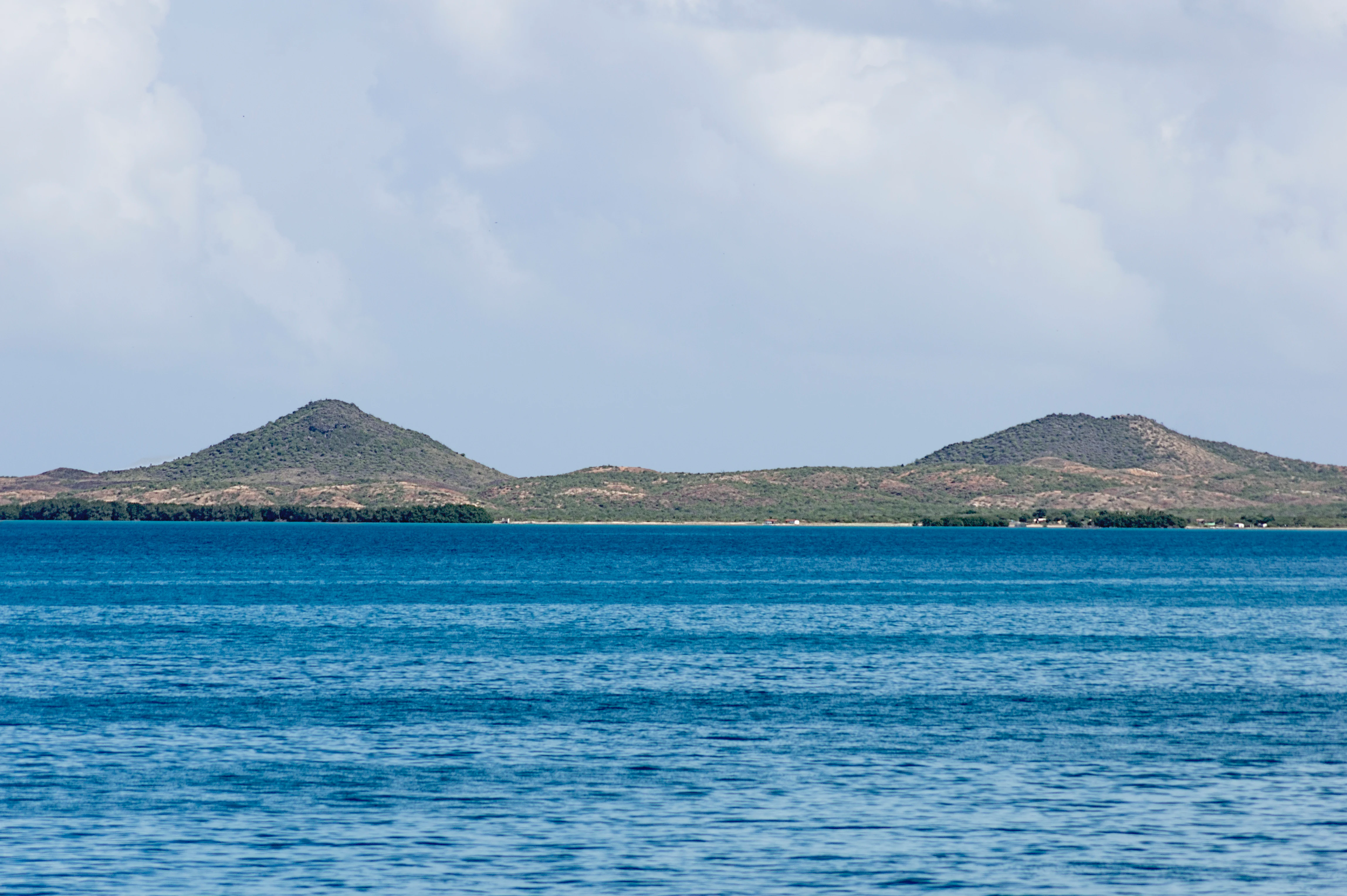
Two prominent, rounded twin hills rise above a calm blue coastal landscape under a cloudy sky.
The twin hills of the Las Tetas de Maria Guevara natural monument rise above the surrounding coastal landscape on Margarita Island.

Las Tetas de María Guevara history and protected-area timeline

The Tetas de María Guevara were officially declared a natural monument on February 27, 1974, placing them under formal protection as a distinctive geographic feature of Isla de Margarita. The designation recognized both their value as a striking landscape landmark and the significance of the surrounding coastal lagoons and mangroves that fall within the protected perimeter.

Long before this formal protection, the twin hills already functioned as an important cultural and navigational reference for the region. Local fishermen traditionally used the hills as a visual landmark when returning to the island from fishing or trade voyages, and the site's popular name had become embedded in local speech through generations of maritime use. The 1974 declaration marked the moment when this long-standing informal importance was translated into official environmental protection within Venezuela's national park framework.

Las Tetas de María Guevara landscape and geographic character

The landscape of Las Tetas de María Guevara is defined by the contrast between the twin hills and the flat terrain that surrounds them. The hills themselves are modest in absolute terms, roughly 135 meters in height, but they stand out dramatically against the arid plain that extends across the central part of Isla de Margarita. Their rounded, symmetrical forms create one of the island's most recognizable silhouettes, visible from considerable distance, including from the ferries crossing between Margarita and the mainland.

Around and between these hills, the protected area extends across low-lying coastal terrain shaped by tidal influence. Within this zone lie three coastal lagoons: Boca de Pala, Laguna de Raya, and Laguna de Punta de Piedras. These shallow water bodies are fringed by mangrove vegetation and form a soft, wetland counterpoint to the dry, scrubby surroundings. The geography of the monument thus combines two very different elements: a pair of isolated, rounded uplands, and a system of mangrove-edged tidal lagoons that link the site to the wider coastal environment of the Laguna de La Restinga area.

Las Tetas de María Guevara ecosystems, habitats, and plant life

Ecologically, the monument reflects the dual character of much of Isla de Margarita: arid lowland terrain interrupted by pockets of coastal wetland. The uplands around the twin hills support dry-adapted vegetation typical of the island's central plains, where rainfall is limited and the landscape tends toward scrub and sparse ground cover. In contrast, the mangrove systems that line Boca de Pala, Laguna de Raya, and Laguna de Punta de Piedras provide a contrasting habitat where salt-tolerant plant communities dominate and where wetland conditions support a different suite of species.

Together, these two ecological zones within a single small protected area give the monument a notable degree of habitat diversity for its size. The transition from dry plain to mangrove lagoon also represents a compact example of the kind of environmental gradient found across Nueva Esparta, where arid island interiors meet productive coastal estuarine systems.

Las Tetas de María Guevara wildlife and species highlights

The wildlife profile of Las Tetas de María Guevara is modest, reflecting the relatively harsh and dry conditions of much of the protected area. Common fauna observed in the monument includes small lizards, rabbits, and snakes, including the rattlesnake and the coral snake (Lampropeltis triangulum). These species are adapted to the arid conditions of the island's central plain rather than to forested or mountainous habitats.

The mangrove-fringed lagoons within the monument likely also support species associated with coastal and estuarine environments, providing an additional wildlife dimension that complements the dry-land fauna of the uplands. Overall, the monument is valued more for its landscape and cultural significance than for the density or variety of its terrestrial wildlife.

Las Tetas de María Guevara conservation status and protection priorities

Las Tetas de María Guevara was declared a natural monument in 1974 in recognition of its distinctive twin-hill landscape and the surrounding mangrove wetland system that falls within its boundaries. The designation places the site within Venezuela's national system of protected areas, administered through the Instituto Nacional de Parques, aiming to preserve both a recognizable cultural landmark and a small but meaningful area of mangrove habitat on Isla de Margarita. The monument's conservation value lies less in charismatic large fauna and more in the preservation of a geographically symbolic landscape and the protection of coastal lagoons, which are ecologically important components of the island's coastal environment.

Las Tetas de María Guevara cultural meaning and human context

The twin hills carry deep cultural resonance on Isla de Margarita and across the state of Nueva Esparta. Local legend links the name of the hills to María Guevara, a businesswoman from Cumaná who is said to have lived on the island. According to tradition, although she was not physically known for a prominent figure, returning fishermen would ironically refer to the hills as "las tetas de la doña" when they spotted the silhouette from the sea, gradually shortening and popularizing the reference until "Las Tetas de María Guevara" became the common name.

Beyond the legend, the hills have long served as a practical cultural symbol. They functioned as a maritime landmark for fishermen guiding themselves toward the island on their return trips, and today they remain one of the strongest visual emblems of Margarita's geography, often photographed from ferries and from the neighboring Laguna de La Restinga. The site thus combines popular folklore, working maritime heritage, and a recognizable island identity into a single protected landmark.

Top sights and standout views in Las Tetas de María Guevara

The defining highlight of Las Tetas de María Guevara is its pair of twin hills rising from a flat, arid coastal plain on Isla de Margarita, creating the monument's iconic and instantly recognizable silhouette. Equally notable is the inclusion within the protected area of three mangrove-fringed coastal lagoons: Boca de Pala, Laguna de Raya, and Laguna de Punta de Piedras. Together, these elements give the monument a combination of cultural symbolism, striking landscape geometry, and a small but meaningful coastal wetland ecosystem, all within a relatively compact 1,670-hectare footprint in the heart of Nueva Esparta.

Best time to visit Las Tetas de María Guevara

The character of a visit to Las Tetas de María Guevara is shaped primarily by the island's tropical, generally dry climate. The twin hills and surrounding plain tend to look their most striking during clearer periods when the dry terrain contrasts sharply with the sky and the hills' silhouettes are most easily visible from the surrounding coast and ferry routes. The mangrove lagoons within the protected area often appear most lush at the edges of the wetter months, when tidal and shallow water conditions shift. Travelers interested in combining the monument with the neighboring Laguna de La Restinga benefit from calmer sea conditions, but the hills themselves remain recognizable as a landmark throughout the year.
Monthly climate preview

Long term temperature and precipitation patterns sampled at representative coordinates

Monumento natural Tetas de María Guevara Climate Normals and Monthly Weather Data

Monumento natural Tetas de María Guevara exhibits measured long term monthly temperatures ranging from 25.33 degrees Celsius to 27.93 degrees Celsius alongside recorded precipitation shifts. Accessing the comprehensive twelve month profile provides complete clarity on historical climate variations across this protected area.
Annual mean27 °C
25 °C28 °C
Jan26°
Feb25°
Mar26°
Apr26°
May27°
Jun27°
Jul27°
Aug27°
Sep28°
Oct28°
Nov27°
Dec26°
Warmest month
September

27.9 °C

Coolest month
February

25.3 °C

Wettest month
August

4.3 mm/day

Driest month
March

0.6 mm/day

Park location guide

Geography guide, regional context, and park location map for Las Tetas de María Guevara

Las Tetas de María Guevara park geography, regions, and map view in Venezuela

Understand where Las Tetas de María Guevara sits in Venezuela through a broader geographic reading of the surrounding landscape, nearby location context, and its mapped position within the national park landscape.

How Las Tetas de María Guevara fits into Venezuela

Venezuela is a country in northern South America with coastline along the Caribbean Sea and Atlantic Ocean. It borders Colombia, Brazil, Guyana, and Trinidad and Tobago. The country has an area of approximately 916,445 km² and a population of about 31.8 million. Caracas is the capital and largest city. Venezuela consists of 23 states and the Capital District.

Wider geography shaping Las Tetas de María Guevara in Venezuela

Venezuela is located on the northern coast of South America. The continental territory is bordered by the Caribbean Sea and Atlantic Ocean to the north, Colombia to the west, Brazil to the south, and Guyana to the east. Trinidad and Tobago lies to the northeast. The country includes various islands and islets in the Caribbean Sea known as the Federal Dependencies.

Map view of Las Tetas de María Guevara

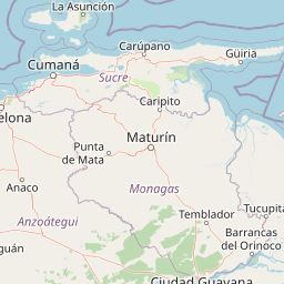
Use this park location map to pinpoint Las Tetas de María Guevara in Venezuela, understand its exact geographic position, and read its mapped placement within the surrounding landscape more clearly.

Pigeon | © OpenStreetMap contributors

Location context for Las Tetas de María Guevara

Nueva Esparta
Recorded earthquake history

Explore Historical Earthquake Records for Monumento natural Tetas de María Guevara

Access a structured archive of seismic activity recorded in the vicinity of these iconic twin hills. This MoriAtlas resource tracks historical epicentres near the coastal plain and wetlands, providing a factual view of documented events for researchers and geography enthusiasts.

Tetas de María Guevara Earthquake History

Catalogued events

10 events

Strongest magnitude

Magnitude 5.2

Most recent event

Oct 17, 2020

This history includes earthquakes recorded inside the park or within 50 km of its borders

Visualizing twin hills, arid coastal plains, and mangrove-fringed lagoons

Monumento natural Tetas de María Guevara Photos and Landscape Scenery

Photographic records capture the distinctive topography of Monumento natural Tetas de María Guevara, highlighting the sharp contrast between isolated upland formations and surrounding tidal wetlands. Visual documentation reveals the ecological character of protected coastal environments, offering clear insight into island terrain and regional geography.

Two prominent, rounded twin hills rise above a calm blue coastal landscape under a cloudy sky.

Park atlas

Compare regional geography, coastal ecosystems, and nearby protected areas.

Parks Near Monumento natural Tetas de María Guevara and Surrounding Protected Landscapes

Browse protected areas and coastal landscapes situated near Monumento natural Tetas de María Guevara. Comparing adjacent regional geography helps reveal wider ecological patterns across the surrounding territory.
A soft-toned watercolor painting of a calm coastal lagoon with marshy green banks and distant hills against a light sky.
National parkNueva Esparta
0.1 km away#1 closest

Northwest

Parque nacional Laguna de La Restinga: Protected Coastal Lagoon and Island Geography

Wetland ecosystems of Nueva Esparta, Venezuela

Parque nacional Laguna de La Restinga protects an extensive coastal lagoon bordered by dense mangrove forests and arid coastal scrub on Isla de Margarita. This critical wetland habitat serves as a biological bridge between the two halves of the island, offering a complex network of channels and sandy flats that support diverse coastal species and marine turtle nesting sites.

Area
188.62 km²
Established
1974
IUCN
II
Relief
Lowland
Watercolor painting of a lake surrounded by forest with mountains in the background
National parkVenezuela
0.2 km away#2 closest

Northwest

Laguna de La Restinga National Park: Venezuela's National Park with Extensive Mangrove Ecosystem

Explore its mapped channels, vital bird habitats, and coastal geography.

Laguna de La Restinga National Park stands as a key protected area within Venezuela, renowned for its expansive shallow salt lagoon and dense mangrove forests. The park's geography is defined by 18 kilometers of natural channels that weave through mangrove islands, offering a unique visual and navigational landscape. As a designated Ramsar Wetland, it is a critical habitat for numerous waterfowl species, providing rich opportunities for landscape and birdwatching discovery. The surrounding terrain reflects the arid conditions typical of the Venezuelan Dry Forest province, contrasting with the vibrant aquatic ecosystem.

Area
188 km²
Established
1974
IUCN
II
Relief
Lowland
National parkNueva Esparta
15 km away#3 closest

East

Cerro El Copey National Park: Mapped Protected Area in Nueva Esparta

Explore the geographic context and landscape of this national park.

Cerro El Copey National Park offers a distinct protected landscape within Nueva Esparta, Venezuela. This page details the park's geographic identity, its mapped boundaries, and its significance as a national park. Investigate the terrain and regional context to understand the protected area's ecological and geographical footprint, providing essential data for atlas-driven exploration.

Area
71 km²
Established
1974
IUCN
II
Relief
Mountain
National parkSucre
52 km away#4 closest

Southwest

Mochima National Park: Venezuela National Park Protected Landscape Atlas

Explore Sucre's mapped conservation boundaries.

Mochima National Park stands as a distinct national park within the Sucre region, offering a focal point for understanding protected landscapes and their geographic context. This entry provides specific details relevant to atlas exploration, allowing for a clear view of the park's mapped boundaries and its contribution to the national park system. Engage with the mapped terrain and regional geography that define this conservation area.

Area
949.35 km²
Established
1973
IUCN
II
Visitors
500K annual
National parkMonagas
83 km away#5 closest

Southeast

Cueva del Guácharo National Park: Venezuela's Protected Natural Landscape

Mapping protected areas and natural terrain in Monagas.

Cueva del Guácharo National Park represents a distinct protected landscape within Venezuela's Monagas region. This entry provides essential context for understanding the park's geographic scope, mapped boundaries, and role as a national park. It is designed to facilitate detailed atlas exploration of protected natural areas and their regional landscape context, offering a foundation for understanding Venezuela's conservation geography.

Area
627 km²
Established
1975
IUCN
II
Relief
Mountain
National parkSucre State
120 km away#6 closest

East

Turuépano National Park: National Park Protected Landscape and Geographic Context

Explore the mapped boundaries and natural terrain of Sucre State's national park.

Investigate Turuépano National Park, a protected national park situated within Sucre State, Venezuela. This entry provides detailed geographic context and information on its mapped protected-area boundaries, essential for understanding its role in the region's natural landscape atlas. Explore the specific terrain and protected land features that define this significant Venezuelan park.

Area
726 km²
Established
1991
IUCN
II
Relief
Lowland
National parkSucre
156 km away#7 closest

East

Península de Paria National Park: Venezuela's Protected Landscape Geography and Atlas Context

Explore mapped park boundaries and regional geographic setting.

Discover Península de Paria National Park, a vital protected area within the Sucre region of Venezuela. This page offers a detailed look at the park's geographic identity, focusing on its mapped boundaries and its significance as a national park for atlas-based exploration. Understand its landscape context and its contribution to Venezuela's network of protected lands, providing a clear geographic overview for researchers and explorers.

Area
375 km²
Established
1978
IUCN
II
Relief
Mountain
Watercolor painting of a lagoon surrounded by green vegetation and mountains in the background
National parkMiranda State
182 km away#8 closest

West

Laguna de Tacarigua National Park: Protected Area and Miranda State Geography

Mapped natural landscape and park boundaries in Venezuela.

Laguna de Tacarigua National Park is a designated national park offering critical protected landscape features within Miranda State. This park provides essential context for understanding Venezuela's protected areas, with a focus on its mapped boundaries and regional geographic setting. Dive into the atlas-style details to comprehend its place in the natural landscape.

Area
391 km²
Established
1974
IUCN
II
Relief
Lowland

Common questions about visiting, size, designation, and location context for Las Tetas de María Guevara

Las Tetas de María Guevara FAQs for park facts, access, geography, and protected area context

Find quick answers about Las Tetas de María Guevara, including protected-area facts, park geography, trail and visitor context, and how the park fits into its surrounding country and regional landscape.
MoriAtlas Explorer

Continue Your Protected Areas Search Across the Global Atlas

Deepen your exploration by continuing the structured search for national parks and protected areas worldwide. Utilize the comprehensive filtering capabilities to compare different conservation landscapes and refine your understanding of global park geography. Discover more about the distribution and characteristics of protected natural areas.

Global natural geography