Mori Atlas logo
National parkLassen Volcanic National Park

Discover the geographic scope and mapped boundaries of this key protected area in California.

Lassen Volcanic National Park: Protected Landscape, Terrain & Map Atlas

Lassen Volcanic National Park serves as a distinct unit within the protected natural areas of California, offering a unique landscape for geographic exploration. This page details the park's mapped boundaries and its place within the regional geography, providing essential context for understanding its protected terrain. Users can delve into the park's identity as a national park and explore its environmental setting through a map-centric lens, aiding in structured discovery of its natural features and conservation landscapes.

Volcanic LandscapeNational ParkCascade RangeGeothermal FeaturesPlug Dome VolcanoCalifornia

Lassen Volcanic National Park

National park

Park overview

Structured park overview, official facts, and landscape profile for Lassen Volcanic National Park

Lassen Volcanic National Park park facts, protected area profile, and essential visitor context

Review the core facts for Lassen Volcanic National Park, including designation, size, terrain, visitor scale, habitats, and operating context in one park-focused overview.

About Lassen Volcanic National Park

Lassen Volcanic National Park preserves one of the most geologically significant landscapes in the United States, offering visitors access to active volcanic features at the southern terminus of the Cascade Range. The park encompasses a remarkable variety of terrain, from the dramatic lava pinnacles and jagged craters of its western section to the expansive lava plateau of its eastern reaches. At the heart of the park stands Lassen Peak, a massive dacite dome that represents the world's largest example of plug dome volcanism. The peak rises to 10,457 feet and forms a striking visual landmark visible across the surrounding landscape. Beyond Lassen Peak, the park contains the remains of Mount Tehama, a former stratovolcano that collapsed to form a two-mile-wide caldera in the late Pleistocene epoch. This complex geological history is complemented by ongoing thermal activity, with hydrothermal features throughout the park demonstrating that volcanic processes continue beneath the surface. The park's establishment in 1916 followed several years of significant eruptive activity between 1914 and 1917, events that brought national attention to this volcanic landscape and prompted its protection as a national park.

Quick facts and research context for Lassen Volcanic National Park

Lassen Volcanic National Park spans approximately 106,452 acres across Shasta, Lassen, Plumas, and Tehama counties in northeastern California. The park was established on August 9, 1916, evolving from two national monuments designated by President Theodore Roosevelt in 1907. Lassen Peak stands at 10,457 feet as the world's largest plug dome volcano and the southernmost non-extinct volcano in the Cascade Range. The Main Park Road reaches 8,512 feet near Lassen Peak, making it the highest road in the Cascades. The park receives extraordinary snowfall, with some areas recording over 600 inches annually, making it among the snowiest locations in California. The park contains 27,130 acres of old-growth forest representing all major forest types found within its boundaries.

Protection and recognition

Verifying the documented conservation framework and official terrestrial management boundaries

Lassen Volcanic National Park Protection Status and Terrestrial Designation

Explorer tools map Lassen Volcanic National Park's official terrestrial protection status and documented conservation boundaries. Structured geographic data helps researchers and conservationists verify the formal management scope and designation framework of the protected land.

Protection details

Protection scope
Terrestrial
Transboundary protection
No
Park context

Deeper park guide and search-rich context for Lassen Volcanic National Park

Lassen Volcanic National Park history, landscape, wildlife, and travel context

Explore Lassen Volcanic National Park through its history, landscape character, ecosystems, wildlife, conservation priorities, cultural context, and seasonal travel timing in a structured park guide built for atlas discovery and search intent.

Why Lassen Volcanic National Park stands out

Lassen Volcanic National Park is best known for its exceptional volcanic diversity, offering the rare opportunity to see all four major volcano types in a single protected area. The park's geothermal areas, particularly Bumpass Hell, showcase active hydrothermal systems with boiling springs, mud pots, and fumaroles. Lassen Peak itself represents the world's largest plug dome volcano, a massive dacite dome that rises dramatically from the landscape. The Cinder Cone and Fantastic Lava Beds provide a striking example of cinder cone volcanism, with the eruption dated to approximately 1666. The park's ongoing volcanic activity makes it a living laboratory for understanding volcanic processes and a rare example of active volcanism in the contiguous United States outside of Alaska.

Lassen Volcanic National Park history and protected-area timeline

The land that now comprises Lassen Volcanic National Park has a rich human history extending long before European-American settlement. The Atsugewi people inhabited this volcanic landscape for generations, understanding the mountain's dangerous nature and believing it would one day destroy itself. European immigrants in the mid-19th century used Lassen Peak as a landmark on their journey to the Sacramento Valley, guided in part by Peter Lassen, a Danish blacksmith who settled in Northern California in the 1830s. The mountain was ultimately named for this guide. The Nobles Emigrant Trail was cut through what is now the park area, passing Cinder Cone and the Fantastic Lava Beds. Historical accounts from the 1850s describe witnessing eruptions at Cinder Cone, with scientific investigation later determining the last eruption occurred between 1630 and 1670, most likely in 1666. The area first received federal protection as the Lassen Peak Forest Preserve, followed by the establishment of Cinder Cone and Lassen Peak National Monuments in 1907 by President Theodore Roosevelt. Beginning in May 1914 and lasting through 1917, a dramatic series of eruptions occurred on Lassen Peak, creating new craters and releasing lava and ash. Because of this eruptive activity and the area's stark volcanic beauty, the region was designated a National Park on August 9, 1916. The 29-mile Main Park Road was constructed between 1925 and 1931, reaching elevations where snow can persist into July. In 1972, a portion of the park was designated as Lassen Volcanic Wilderness. The 2021 Dixie Fire became the largest wildfire in park history, burning approximately 73,240 acres or about 69 percent of the park.

Lassen Volcanic National Park landscape and geographic character

The landscape of Lassen Volcanic National Park presents a dramatic contrast between its western and eastern regions. The western portion features imposing lava pinnacles formed by ancient lava flows, jagged craters, and steaming sulfur vents, all cut by glaciated canyons and dotted with clear mountain lakes and rushing streams. The eastern section reveals a vast lava plateau standing more than a mile above sea level, studded with small cinder cones including Fairfield Peak, Hat Mountain, and Crater Butte. This plateau area is forested with pine and fir but contains few streams, though Warner Valley at the southern edge features notable hot spring areas including Boiling Springs Lake, Devils Kitchen, and Terminal Geyser. Lassen Peak itself, composed of dacite igneous rock, sits on the northeastern flank of the ancient Mount Tehama, whose collapsed caldera now forms a significant portion of the park's terrain. The landscape also includes four shield volcanoes ranging from 7,000 to 8,400 feet in elevation: Mount Harkness in the southwest, Red Mountain at the south-central boundary, Prospect Peak in the northeast corner, and Raker Peak north of Lassen Peak. Despite the lack of modern glaciers, the park contains 14 permanent snowfields, and the higher elevations display the scars of past glacial periods.

Lassen Volcanic National Park ecosystems, habitats, and plant life

Lassen Volcanic National Park lies at the northern end of the Sierra Nevada forests ecoregion and preserves a landscape that closely resembles its pre-European settlement condition. The park contains approximately 27,130 acres of old-growth forest representing all major forest types found within its boundaries. Below elevations of 6,500 feet, a rich mixed conifer forest dominates, with ponderosa pine, Jeffrey pine, sugar pine, and white fir forming the canopy. This diverse community also includes manzanita, gooseberry, and Ceanothus, while common wildflowers such as iris, spotted coralroot, pyrola, violets, and lupin add seasonal color. Between 6,500 and 8,000 feet, the red fir forest becomes the dominant community, featuring red fir, western white pine, mountain hemlock, and lodgepole pine in a somewhat less diverse association. Subalpine areas from 8,000 feet to treeline represent the upper limit for tree growth, with whitebark pine and mountain hemlock among the species that survive in this harsh environment. The park's geothermal areas support specialized organisms capable of surviving in extremely hot conditions, representing extremophile micro-organisms of scientific interest.

Lassen Volcanic National Park wildlife and species highlights

Lassen Volcanic National Park supports a diverse community of wildlife species adapted to its forest, meadow, and alpine habitats. The park is home to the Sierra Nevada red fox, one of the rarest mammals in California, with approximately 20 individuals identified in the park representing the largest known population of this elusive creature. Mammals commonly found in the forested areas include black bear, red fox, mule deer, marten, cougar, coyote, bobcat, and various species of chipmunks, squirrels, and mice. The park also supports mountain chickadee, brown creeper, white-headed woodpecker, and a wide variety of bat species. In 2024, a wolf pack was reported within the park for the first time in modern times, likely formed from dispersing members of the Lassen Pack that inhabits the surrounding forest. Wetland and lake areas such as Reflection Lake attract waterfowl including Canada geese, great blue heron, snowy egret, and kingfisher. The American pika inhabits rocky alpine areas, while the long-toed salamander and various skunk species round out the park's vertebrate diversity.

Lassen Volcanic National Park conservation status and protection priorities

Lassen Volcanic National Park represents a significant conservation achievement in preserving both volcanic geological features and diverse ecological communities. The park's designation as Lassen Volcanic Wilderness in 1972, following the Wilderness Act of 1964, ensures that a portion of this unique landscape will remain in a relatively undeveloped state with minimal facilities and trails. The park preserves 27,130 acres of old-growth forest, representing all major forest types within its boundaries and providing critical habitat for species like the Sierra Nevada red fox. Following the 1980 eruption of Mount St. Helens, the United States Geological Survey intensified monitoring of active and potentially active volcanoes in the Cascade Range, including the Lassen area. The USGS maintains a network of nine seismometers in the park, continuously transmitting data to offices in Menlo Park, California, while also conducting periodic measurements of ground deformation and volcanic-gas emissions. This monitoring capability allows scientists to rapidly deploy additional equipment should signs of significant volcanic activity be detected. The National Park Service has also developed an emergency response plan to protect visitors in the event of an impending eruption. The 2021 Dixie Fire, while devastating, provided valuable information about fire ecology in this volcanic landscape.

Lassen Volcanic National Park cultural meaning and human context

The cultural history of Lassen Volcanic National Park extends far beyond its designation as a protected area. The Atsugewi people have inhabited this volcanic region since long before European-American settlers arrived, developing a deep understanding of the landscape's dangerous nature. Their traditional knowledge included the understanding that Lassen Peak was full of fire and water and would one day blow itself apart, a belief that proved prescient given the eruptions that occurred in the early 20th century. The park was named after Peter Lassen, a Danish blacksmith who became one of the guides leading immigrant parties to the Sacramento Valley in the 1830s. The Nobles Emigrant Trail, an important overland route, passed through the park area, crossing near Cinder Cone and the Fantastic Lava Beds. The modern Kohm Yah-mah-nee Visitor Center, opened in 2008, was named after the Mountain Maidu name for Lassen Peak, acknowledging the indigenous heritage of this landscape. The park also contains the Loomis Museum, dedicated to Benjamin F. Loomis, who played a significant role in documenting the early 20th-century eruptions and supporting the park's establishment.

Top sights and standout views in Lassen Volcanic National Park

The geothermal area of Bumpass Hell represents one of the park's most dramatic highlights, featuring boiling springs, mud pots, and fumaroles that demonstrate the ongoing volcanic activity beneath the surface. Lassen Peak itself offers hikers access to the summit of the world's largest plug dome volcano, with the trail passing through areas affected by the early 20th-century eruptions. The Cinder Cone and Fantastic Lava Beds provide a striking example of cinder cone volcanism, with the red and black lava formations creating a visually dramatic landscape. The Main Park Road, reaching 8,512 feet in elevation, is the highest road in the Cascade Mountains and offers spectacular views of the volcanic terrain. Kings Creek and the park's numerous lakes, including Lake Helen with its vivid blue color, provide scenic destinations. The Painted Dunes and Fantastic Lava Beds, viewed from the edge of Cinder Cone's crater, offer one of the park's most photographed vistas. The diverse forest communities, ranging from mixed conifer at lower elevations to subalpine forests near treeline, provide seasonal interest throughout the year.

Best time to visit Lassen Volcanic National Park

The best time to visit Lassen Volcanic National Park depends on the experience sought, with each season offering distinct advantages. Summer and early fall typically offer the most accessible conditions, with the Main Park Road typically open from late spring through October, though heavy snowfall can close the road as early as November. The summer months allow access to all major trailheads and geothermal areas like Bumpass Hell, though afternoon thunderstorms are common. The park receives extraordinary snowfall during winter months, with some areas recording over 600 inches annually, and snow can persist at higher elevations well into July. Fall offers a particularly beautiful time to visit as the forests display autumn color and visitor numbers decrease from summer peaks. Those interested in winter recreation should note that the downhill skiing operation that once operated in the park was closed in 1992. Spring visitors should be prepared for variable conditions as snow melts and streams rise. Regardless of season, visitors should be aware that the park remains geologically active and should follow all posted warnings regarding thermal areas.
Monthly climate preview

Long term temperature and precipitation cycles modeled from a representative park elevation

Lassen Volcanic National Park Climate Normals and Monthly Weather Averages

Climatological records from a representative elevation of 1700 meters reveal a cycle marked by warm, dry intervals with maximums exceeding 30 degrees Celsius alongside cold, wet months where mean temperatures drop below freezing. Comparing the complete twelve-month profile provides critical baseline metrics for understanding localized mountain conditions and shifting monthly averages across the protected landscape.
Annual mean8 °C
-1 °C20 °C
Jan-1°
Feb
Mar
Apr
May
Jun14°
Jul20°
Aug19°
Sep15°
Oct
Nov
Dec-1°
Warmest month
July

19.8 °C

Coolest month
December

-1.4 °C

Wettest month
December

5.7 mm/day

Driest month
July

0.2 mm/day

Park location guide

Geography guide, regional context, and park location map for Lassen Volcanic National Park

Lassen Volcanic National Park park geography, regions, and map view in United States of America

Understand where Lassen Volcanic National Park sits in United States of America through a broader geographic reading of the surrounding landscape, nearby location context, and its mapped position within the national park landscape.

How Lassen Volcanic National Park fits into United States of America

The United States of America is a federal presidential republic and one of the world's largest countries by area and population. It consists of 50 states across a vast territory spanning multiple time zones, with its capital in Washington, D.C. and largest city in New York City. The nation has a diverse economy, influential political system, and significant cultural and military presence globally.

Wider geography shaping Lassen Volcanic National Park in United States of America

The United States occupies a vast territory in North America, bordered by Canada to the north and Mexico to the south. The 48 contiguous states stretch from the Atlantic to the Pacific Ocean, while Alaska occupies the northwestern region and Hawaii is an archipelago in the Pacific. The country encompasses diverse terrain including the Rocky Mountains, Appalachian Mountains, Great Plains, and extensive river systems.

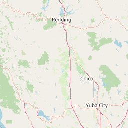
Map view of Lassen Volcanic National Park

Use this park location map to pinpoint Lassen Volcanic National Park in United States of America, understand its exact geographic position, and read its mapped placement within the surrounding landscape more clearly.

Pigeon | © OpenStreetMap contributors

Location context for Lassen Volcanic National Park

CaliforniaLassen CountyPlumas CountyShasta CountyTehama County
Natural feature types

Explore the Geological Features of Lassen Volcanic National Park

Investigate the specific landforms and natural landmarks defined within the Lassen Volcanic National Park dataset. MoriAtlas facilitates deep geographic discovery by organizing these features according to their geological classification and spatial proximity to key park sectors.
Recorded earthquake history

Review the Historical Earthquake Catalogue for Lassen Volcanic National Park

Continue exploring the geographic data for Lassen Volcanic National Park by accessing the recorded earthquake history. This collection provides transparent access to USGS seismic logs, allowing for the review of historical event timing, magnitude, and relative proximity to the park landscape.

Lassen Volcanic National Park Earthquake Records

Catalogued events

204 events

Strongest magnitude

Magnitude 5.7

Most recent event

Jun 14, 2026

This history includes earthquakes recorded inside the park or within 50 km of its borders

Park atlas

Trace the Volcanic Landscape and Connected Protected Areas Across California's Cascade Range

Discover Other National Parks and Protected Areas Near Lassen Volcanic National Park

Continue your exploration from Lassen Volcanic National Park by browsing other national parks and protected areas located across the diverse Cascade Range region of California. Compare varied conservation landscapes, trace broader geographic features, and deepen your understanding of the interconnected volcanic and alpine environments.
Protected landscapeCalifornia
Park boundaries overlap#1 closest

East

Lassen National Forest: Mapped Geography and Protected Landscapes of Northern California

Volcanic terrain and expansive old growth ecosystems

Lassen National Forest represents a vast protected landscape in Northern California, defined by its severe volcanic geology and resilient conifer forests. This atlas entry provides essential geographic context regarding the forest boundaries, the volcanic rim of Mount Tehama, and the intricate river systems shaping the region. Explore the terrain, from accessible lava tubes to the wilderness areas preserved within this significant mountain corridor.

Area
4,331.53 km²
Established
1905
Relief
Mountain
Climate
Temperate
Protected landscapeCalifornia
27 km away#2 closest

Southeast

Plumas National Forest: Mapped Geography and Protected Landscape Features in California

Exploring the Sierra Nevada watershed and wilderness terrain

Plumas National Forest serves as a critical protected landscape in northern California, anchoring the headwaters of the Feather River system. This atlas entry details the forest's rugged canyons, high elevation mountain lakes, and significant old growth conifer stands that define its role within the northern Sierra Nevada ecosystem.

Area
4,640 km²
Established
1907
Relief
Mountain
Climate
Mediterranean
Wildlife reserveCalifornia
29 km away#3 closest

Southwest

Ishi Wilderness Wildlife Reserve: Mapping the Volcanic Canyons of the Cascade Foothills

Geographic atlas of protected northern California wilderness and cultural landscapes.

Ishi Wilderness represents a crucial protected area in northern California, where volcanic geology meets a deep-rooted cultural history. Explore the mapped ridgelines, river canyons, and diverse oak woodland habitats that define this unique wildlife reserve and its role within the Cascade foothills.

Area
167.29 km²
Established
1984
IUCN
Ib
Relief
Mountain
Protected landscapeCalifornia
39 km away#4 closest

North

Modoc National Forest: Protected Landscape and Warner Mountains Geography

High desert volcanic terrain in northeastern California

Modoc National Forest encompasses a massive expanse of volcanic plateaus and rugged mountain ridges in the northeastern corner of California. This protected area offers significant geographic variety, transitioning from arid sagebrush basins to lush, high-elevation conifer forests. It serves as a vital natural landscape, home to the South Warner Wilderness and large stands of old-growth timber, reflecting the unique geologic history of the regional lava flows.

Area
6,695.09 km²
Established
1904
Relief
Mountain
Access
Moderate access
Protected landscapeCalifornia
43 km away#5 closest

West

Shasta, Trinity National Forest: Mapping the Protected Landscapes of Northern California

Volcanic peaks, expansive reservoirs, and rugged mountain wilderness

Spanning over two million acres, Shasta, Trinity National Forest represents a major protected landscape in Northern California. The geography includes the iconic Mount Shasta volcano and the complex shoreline of Shasta Lake, while hosting expansive wilderness areas and diverse terrain ranging from oak-forested foothills to alpine meadows.

Area
8,942.87 km²
Established
1954
Relief
Mountain
Climate
Temperate
Protected landscapeCalifornia
79 km away#6 closest

West

Whiskeytown, Shasta, Trinity National Recreation Area: Geographic and Protected Landscape Overview

Mapped terrain across northern California reservoir units

Investigate the environmental character of Whiskeytown, Shasta, Trinity National Recreation Area, spanning from the expansive waters of Shasta Lake to the forested ridges of the Whiskeytown unit. This atlas entry details the interplay between large-scale reservoir management, riparian habitats, and the transition from Mediterranean chaparral to high-elevation conifer forests in California.

Area
99,588 km²
Established
1965
IUCN
V
Visitors
1.5M annual
Protected landscapeCalifornia
87 km away#7 closest

Southeast

Tahoe National Forest: Exploring Protected Mountain Landscapes in the California Sierra Nevada

An atlas of granite river canyons and alpine ridge terrain

Tahoe National Forest defines a critical segment of the western Sierra Nevada, containing granite river canyons, numerous reservoirs, and summits reaching above 9,000 feet. This protected landscape acts as a vital headwater for California foothill communities and Nevada, hosting significant natural features like the Placer County Big Trees Grove and segments of the Pacific Crest Trail.

Area
3,526.82 km²
Established
1899
Relief
Mountain
Climate
Mediterranean
Wildlife reserveCalifornia
99 km away#8 closest

Northwest

Mount Shasta Wilderness: A Geographic Profile of California Volcanic and Alpine Landscapes

Mapping protected volcanic peaks and glacial ecosystems

Deeply explore the protected geography of Mount Shasta Wilderness, a 38,200-acre reserve in Northern California. This record details the park's stratovolcano foundations, glacial terrain, and forested corridors, offering a clear view of the complex landforms and boundary systems that define this significant high-elevation protected area.

Area
155 km²
Established
1984
IUCN
Ib
Relief
Mountain

Common questions about visiting, size, designation, and location context for Lassen Volcanic National Park

Lassen Volcanic National Park FAQs for park facts, access, geography, and protected area context

Find quick answers about Lassen Volcanic National Park, including protected-area facts, park geography, trail and visitor context, and how the park fits into its surrounding country and regional landscape.
MoriAtlas Explorer

Continue Your Protected Areas Search Across the Global Atlas

Deepen your exploration by continuing the structured search for national parks and protected areas worldwide. Utilize the comprehensive filtering capabilities to compare different conservation landscapes and refine your understanding of global park geography. Discover more about the distribution and characteristics of protected natural areas.

Global natural geography