Mori Atlas logo
State or regional parkLava Forks Provincial Park

Examine the mapped boundaries and fresh volcanic terrain of this remote northern wilderness protected area.

Lava Forks Provincial Park: A Geologically Recent Volcanic Landscape in Northern British Columbia

Lava Forks Provincial Park serves as a significant protected area in northern British Columbia, preserving the site of one of Canada's most recent volcanic eruptions. The park contains a stark landscape of ash dunes, lava flows, and dammed lakes that contrast with the surrounding mountain wilderness. Users can study the geological composition and mapped extent of this isolated terrain, which remains a key example of raw volcanic processes situated near the international border.

volcanic landscapegeological conservationremote wildernessbackcountrysubalpine environmenttransboundary protected area

Lava Forks Provincial Park

State or regional park

Park overview

Structured park overview, official facts, and landscape profile for Lava Forks Provincial Park

Lava Forks Provincial Park park facts, protected area profile, and essential visitor context

Review the core facts for Lava Forks Provincial Park, including designation, size, terrain, visitor scale, habitats, and operating context in one park-focused overview.

About Lava Forks Provincial Park

Lava Forks Provincial Park is a small but strikingly unusual provincial park in northern British Columbia, Canada, established on January 25, 2001 and managed by BC Parks under an IUCN Category III designation as a natural monument or feature. The park's defining feature is its connection to the Lava Fork area, where Canada's most recent volcanic eruption took place around 1904 from a vent known as The Volcano. Today the surrounding landscape preserves a suite of volcanic landforms that remain unusually fresh by Canadian standards, giving the park a character quite different from the forested mountains that dominate much of the province.

The park lies within the Kitimat-Stikine Regional District, well to the southwest of the small community of Telegraph Creek, and sits within the traditional territory of the Tahltan Nation. Its southern boundary follows the Canada, United States border, directly abutting the Tongass National Forest in Alaska. Because of this geography, the park functions less as a stand-alone destination and more as a protected extension of a broader transboundary wilderness that includes coastal Alaskan temperate rainforest and remote B.C. interior mountains.

Although Lava Forks is a small protected area in absolute terms, its protected status under BC Parks gives formal recognition to a landscape that would otherwise be vulnerable to forestry, mining, or other resource pressures affecting the region. By being classified as a natural monument or feature, the park is managed primarily for the protection of its geological character rather than for recreation or development, which aligns with its inaccessibility and the remote, helicopter-dependent nature of visitation.

Quick facts and research context for Lava Forks Provincial Park

Lava Forks Provincial Park is a small but geologically distinctive protected area in the Kitimat-Stikine region of northern British Columbia, established in 2001 and managed by BC Parks. Its core identity is tied to the Lava Fork vent, the source of Canada's most recent volcanic eruption around 1904. The park lies near the southern border with Alaska and the Tongass National Forest, and is accessible mainly by helicopter or long徒步 approaches rather than by road.

Protection and recognition

Terrestrial protected area classification and documentation framework

Lava Forks Provincial Park Protection Status and Mapped Designation Records

Lava Forks Provincial Park maintains a documented terrestrial protection scope within official conservation registries. Conservation records catalog administrative classification details and international recognition status for accurate geographic analysis.

Protection details

Protection scope
Terrestrial
Transboundary protection
No
Park context

Deeper park guide and search-rich context for Lava Forks Provincial Park

Lava Forks Provincial Park history, landscape, wildlife, and travel context

Explore Lava Forks Provincial Park through its history, landscape character, ecosystems, wildlife, conservation priorities, cultural context, and seasonal travel timing in a structured park guide built for atlas discovery and search intent.

Why Lava Forks Provincial Park stands out

The park is best known for preserving the volcanic landscape associated with the 1904 eruption of The Volcano, which produced Lava Fork. Within the park, visitors can see fresh-looking lava flows, ash dunes, lava-dammed lakes, and small pothole pools, all features rare in southern Canada and unusually young in geological terms. Because the eruption occurred less than a century and a half ago, the volcanic landforms at Lava Forks still retain sharp, fresh characteristics normally associated with far more remote or recent volcanic regions. This combination of youth, exposure, and remote Canadian setting is what makes the park distinctive compared with other protected areas in British Columbia.

Lava Forks Provincial Park history and protected-area timeline

The land that Lava Forks Provincial Park now protects had been a landscape of geological interest long before its formal protection, owing to the 1904 eruption that produced the lava flows, ash dunes, and dammed lakes still visible in the park today. The eruption at Lava Fork is recognized across Canada as the country's most recent volcanic event, and the site's significance grew over the 20th century as researchers, geologists, and travelers recognized the rarity of such fresh volcanic features in a Canadian setting.

The park itself was established on January 25, 2001, when the Province of British Columbia formally designated Lava Forks as a provincial park. Its establishment came as part of a broader movement in B.C. to protect areas of geological, ecological, or cultural distinctiveness, and its IUCN Category III classification reflects its focus on preserving a specific natural feature rather than a large-scale ecosystem. Manage

The surrounding territory has long been associated with the Tahltan Nation, whose traditional territory includes the park area. While the park's formal recognition is recent, the human and cultural history of the region goes back far beyond 2001, with the Tahltan people having longstanding relationships with the land that the park now protects.</continued> </continued> </continued> </continued> </continued> </continued> </continued> </continued> </continued> </continued> </continued> </continued> </continued> </continued> </continued> </continued> </continued> </continued> </continued> </continued> </continued> </continued> </continued> </continued> </continued> </continued> </continued> </continued> </documentation> </response>

Lava Forks Provincial Park landscape and geographic character

The landscape of Lava Forks Provincial Park is defined primarily by its volcanic origin, with terrain that reflects the 1904 eruption of The Volcano and the associated activity at Lava Fork. Rather than the rolling, glacier-carved peaks typical of much of the B.C. coast mountains, the park's surface features include dark lava flows, ash dunes, and small basins dammed by cooled volcanic material. These features remain visually fresh and sharply defined, a striking contrast with the surrounding vegetated wilderness.

Another defining element of the park's landscape is the series of small lakes and pools formed where past lava flows blocked existing drainage. Some of the most distinctive features are pot holes containing crystal clear pools, formed as gas pockets or surface irregularities in the lava flows later filled with water. The combination of hardened lava, loose ash, and water features creates a varied and unusual surface geology within a relatively compact area.

The broader setting amplifies the sense of remoteness and scale. The park sits in a transitional zone between the interior plateaus and ranges of northern British Columbia and the temperate rainforest systems of the Alaska Panhandle, with the Tongass National Forest visible just across the international boundary to the south. Because the park has no road or river access and only limited trail access, the landscape remains an unmodified mixture of volcanic substrate, boreal and subalpine vegetation, and adjacent mature wilderness.

Lava Forks Provincial Park ecosystems, habitats, and plant life

Lava Forks Provincial Park is ecologically interesting because it represents an unusual intersection of volcanic substrate, high-latitude climate, and transitional vegetation between interior and coastal biomes. The fresh lava flows and ash deposits create patches of sterile or early-successional ground where primary plant colonization is still visibly underway. This makes parts of the park function as natural laboratories of ecological recovery on volcanic terrain, distinct from the older, fully vegetated surroundings.

Away from the most recent flows, vegetation grades into the subalpine and boreal forest types typical of northwestern British Columbia, with conifers, hardy shrubs, and ground cover adapted to short growing seasons and deep snowpack. The park's position near the border with Alaska's Tongass National Forest also means that elements of coastal temperate rainforest influence can appear in some sheltered valleys, contributing to a transitional ecological character.

The park's relatively small size and focus on geological protection mean that its ecological value is best understood as part of a larger wilderness complex. In this sense, Lava Forks functions less as a standalone ecosystem reserve and more as a protected core of volcanic terrain embedded within a wider matrix of northern B.C. and southeastern Alaskan wilderness.

Lava Forks Provincial Park wildlife and species highlights

Because the park is small, remote, and dominated by recent volcanic substrate rather than mature habitat, wildlife patterns at Lava Forks tend to reflect the surrounding wilderness rather than rely on the park alone. Fauna typical of northern B.C.'s interior and subalpine zones can be expected to move through or seasonally use the park, including species such as moose, mountain goats, black bears, and various smaller mammals adapted to boreal and subalpine environments.

The park's lakes and pools, including the lava-dammed lakes and pothole pools, provide localized freshwater habitat in an otherwise rugged and dry volcanic landscape. These waterbodies can attract waterfowl and other birdlife, and together with surrounding forest and alpine terrain they contribute to a habitat mosaic that supports typical northwestern bird communities. Fishing is permitted in the park under appropriate licensing, which indirectly reflects the presence of viable freshwater fish populations in these waters.

Lava Forks Provincial Park conservation status and protection priorities

From a conservation perspective, Lava Forks Provincial Park is significant primarily for its geological value rather than its size. As an IUCN Category III protected area, it is designated specifically as a natural monument or feature, a status reserved for sites where the protection of a single distinctive natural feature is the primary objective. In the case of Lava Forks, that feature is the volcanic landscape produced by Canada's most recent eruption.

The park's conservation importance can be understood on several levels. First, it preserves one of the youngest and most accessible volcanic terrains in Canada, offering educational and scientific value for the study of recent volcanic processes. Second, its formal protection shields that terrain from extractive pressures such as mining or commercial forestry that affect parts of the surrounding landscape. Third, by being situated adjacent to the Tongass National Forest in Alaska, the park contributes to a broader transboundary network of protected wilderness along the Canada, United States border.

The park's remote character, with no road or water access and only徒步 or helicopter access, has historically helped protect it simply by limiting human impact. Formal park designation under BC Parks reinforces that natural protection by adding an institutional layer of oversight and management geared toward preserving the park's volcanic and wilderness character for the long term.

Lava Forks Provincial Park cultural meaning and human context

Lava Forks Provincial Park lies within the traditional territory of the Tahltan Nation, whose presence in this part of northwestern British Columbia long predates the park's establishment. The Tahltan people have historic and ongoing relationships with the broader landscape of the Stikine region, including the valleys, rivers, and mountains that surround the Lava Forks area. The park's formal designation acknowledges, through the language of traditional territory, that the protected landscape is part of a cultural region with deep Indigenous roots.

Beyond Indigenous associations, the park has more limited modern cultural or settlement history because of its inaccessibility. There are no permanent communities within the park, and the nearest settlement of any size, Telegraph Creek, lies far to the northeast. The remote Transboundary region in which the park sits is characterized more by wilderness travel, Indigenous land use, and cross-border ecological connections than by settled European-style cultural development, and Lava Forks is shaped by that same pattern.

Top sights and standout views in Lava Forks Provincial Park

Lava Forks Provincial Park's standout qualities are its youth, its volcanic specificity, and its remote wilderness setting. The most prominent highlights include the freshly preserved lava flows and ash dunes from the 1904 eruption, the unusual lava-dammed lakes and crystal-clear pothole pools that dot the volcanic terrain, and the sense of being on the edge of two great wilderness systems: the interior mountains of northern British Columbia and the coastal forests of Alaska's Tongass National Forest just across the border.

Best time to visit Lava Forks Provincial Park

Given the park's high-latitude northern location, short summer season, and snow-heavy winters, the most favorable window for any visit is the brief summer period when snow has melted at lower elevations, volcanic features are most visible, and徒步 approaches are most feasible. Winters bring deep snow cover and severe conditions that make both foot and helicopter access far more difficult.

Visit timing is also shaped by what a visitor hopes to see. Those interested in the full volcanic landscape, including clear views of lava flows, ash dunes, and pools, generally benefit from late spring through early autumn, when snow is absent and the geology is fully exposed. Visitors focused on wilderness atmosphere or backcountry experience should similarly aim for the warmer months, when longer daylight supports multi-day徒步 access to the park from surrounding trails or staging areas.
Monthly climate preview

Long-term temperature and precipitation patterns across twelve monthly periods

Lava Forks Provincial Park Climate Normals and Monthly Weather Records

Lava Forks Provincial Park exhibits a measured annual cycle of sustained sub-zero winter temperatures alongside moderate summer maximums and varying precipitation rates. Examining the complete monthly climate normals reveals detailed temperature variations and precipitation distributions across the representative coordinate.
Annual mean-2 °C
-11 °C9 °C
Jan-11°
Feb-10°
Mar-7°
Apr-3°
May
Jun
Jul
Aug
Sep
Oct-1°
Nov-8°
Dec-10°
Warmest month
July

8.9 °C

Coolest month
January

-10.5 °C

Wettest month
October

8.6 mm/day

Driest month
May

3.4 mm/day

Park location guide

Geography guide, regional context, and park location map for Lava Forks Provincial Park

Lava Forks Provincial Park park geography, regions, and map view in Canada

Understand where Lava Forks Provincial Park sits in Canada through a broader geographic reading of the surrounding landscape, nearby location context, and its mapped position within the national park landscape.

How Lava Forks Provincial Park fits into Canada

Canada is a federal parliamentary constitutional monarchy spanning North America from the Atlantic to the Pacific and Arctic Oceans. With a population of over 41 million, it is officially bilingual in English and French at the federal level. The country gained independence from the United Kingdom through a gradual process culminating in 1982.

Wider geography shaping Lava Forks Provincial Park in Canada

Canada occupies the northern portion of North America, sharing its longest international border with the United States. The country extends from the Atlantic Ocean to the Pacific Ocean and northward into the Arctic Ocean, giving it the longest coastline of any nation.

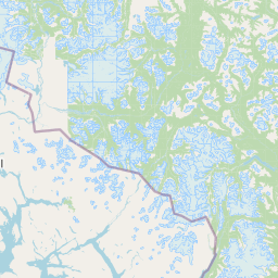
Map view of Lava Forks Provincial Park

Use this park location map to pinpoint Lava Forks Provincial Park in Canada, understand its exact geographic position, and read its mapped placement within the surrounding landscape more clearly.

Pigeon | © OpenStreetMap contributors

Location context for Lava Forks Provincial Park

British Columbia
Park atlas

Compare regional mountain wilderness and related protected landscapes in northern British Columbia.

Other Parks Near Lava Forks Provincial Park and Surrounding Protected Areas

Browse protected areas and regional reserves adjacent to Lava Forks Provincial Park for broader geographic comparison. Exploring these neighboring wilderness zones reveals the diverse geological terrain and mountain ecosystems defining northwestern Canada.
State or regional parkBritish Columbia
About 71 km away#1 closest

Northwest

Great Glacier Provincial Park: Glacial Geography and Protected Wilderness in Northern British Columbia

A rugged mountain landscape within the Stikine River corridor.

Great Glacier Provincial Park protects a compact, visually intense glacial environment along the Stikine River. Established to preserve the dramatic Great Glacier as it descends from the Boundary Ranges, this protected area features deep river valleys, steep mountainous slopes, and a unique ecological transition zone near the international border.

Area
93 km²
Established
2001
IUCN
II
Relief
Mountain
Nature reserveBritish Columbia
About 177 km away#2 closest

Northeast

Gladys Lake Ecological Reserve: Remote Wilderness and Alpine Geography in British Columbia

Scientific reference area on the Spatsizi Plateau

Explore the expansive geography of Gladys Lake Ecological Reserve, a major protected area located in the remote interior of British Columbia. This reserve provides a strictly preserved natural landscape defined by high-elevation ridges, subalpine transitions, and the pristine wilderness of the Eaglenest Range, serving as a benchmark for ecological research in Canada.

Area
440.98 km²
Established
1975
IUCN
Ia
Relief
Mountain
A minimalist watercolor painting showing layered hills and coastal terrain in soft shades of green, gray, and pink, resembling the Alaskan wilderness.
Wildlife reserveAlaska
About 198 km away#3 closest

West

Kuiu Wilderness: An Alaska Protected Area of Temperate Rainforest and Fjord Geography

A remote wilderness expanse within the Alexander Archipelago

The Kuiu Wilderness serves as a primary example of coastal conservation in Alaska, offering a vast roadless territory that spans from sea level to alpine elevations. Mapped through a series of deep fjords and temperate rainforests, this reserve provides a critical look at the complex landscape transitions that define the ecology of the Alexander Archipelago.

Area
245.16 km²
Established
1990
Relief
Mountain
Climate
Temperate
Wildlife reserveAlaska
About 200 km away#4 closest

Northwest

Kootznoowoo Wilderness: Coastal Rainforest and Island Protected Area Map in Alaska

A vast temperate wilderness within the Tongass National Forest

Kootznoowoo Wilderness stands as a landmark protected landscape in Southeast Alaska, spanning the majority of Admiralty Island. Its geography is characterized by towering old-growth conifers, fern-covered understories, and a rugged coastline carved by glacial forces. This wildlife reserve provides a vital refuge for dense brown bear populations and remains one of the most intact examples of a maritime temperate rainforest in North America.

Area
3,962.19 km²
Established
1980
IUCN
Ib
Relief
Mixed relief
State or regional parkBritish Columbia
About 214 km away#5 closest

South

Khutzeymateen Provincial Park: Protected Wilderness and Coastal Forest Geography

North Coast British Columbia protected area and estuary map.

Khutzeymateen Provincial Park represents a pivotal conservation achievement on the British Columbia North Coast. This wilderness sanctuary protects a critical estuarine complex where rugged mountain ranges meet a sheltered Pacific inlet. Beyond its designation as a grizzly bear stronghold, the park holds globally significant old-growth Sitka spruce forests, providing a rare look at an intact temperate rainforest landscape.

Area
450.52 km²
Established
1994
IUCN
Ib
Relief
Mountain
State or regional parkBritish Columbia
About 235 km away#6 closest

Southeast

Kitsumkalum Provincial Park: Geography and Landscape Atlas of Northern British Columbia

Mapped protected areas and forest terrain in the Skeena region

Kitsumkalum Provincial Park serves as a compact protected node within the mountainous landscape of northern British Columbia. This record details the park's transition from lake to river outlet, the surrounding coniferous forests, and the geographic significance of the Skeena watershed. Gain spatial insight into the park boundaries and the historical context of its shoreline where early homesteading once flourished.

Area
0.4 km²
Established
1946
IUCN
II
Relief
Lowland
Wildlife reserveAlaska
About 247 km away#7 closest

Southwest

Forrester Island Wilderness: Mapped Protected Landscapes and Wildlife Reserve Geography

Isolated island terrain in the Alaska Maritime National Wildlife Refuge

This remote wilderness area in Alaska features a mountainous, forested profile and sheer coastal cliffs that drop directly into the Pacific Ocean. Its protected boundaries are vital for maintaining undisturbed marine mammal habitat and temperate coastal forest ecosystems, offering a distinct example of isolated island geography within the United States.

Area
10.29 km²
Established
1912
Relief
Upland
Climate
Temperate
A watercolor painting showing a lake, a forested shoreline, and distant mountains in a soft palette.
State or regional parkBritish Columbia
About 252 km away#8 closest

South

Diana Lake Provincial Park: Mapping Coastal Rainforest and Wetland Geography in British Columbia

An examination of North Coast forest and freshwater ecosystems

Diana Lake Provincial Park represents a significant protected area in British Columbia, showcasing the diverse ecological character of the North Coast. The park boundary encompasses a mosaic of old-growth rainforest, open blanket bogs, and freshwater aquatic systems. By protecting these varied terrains, the region maintains vital habitats for Pacific salmon species while providing a structured landscape for understanding the wet maritime environment of the Pacific Northwest.

Area
2.33 km²
Established
1980
IUCN
II
Relief
Upland

Common questions about visiting, size, designation, and location context for Lava Forks Provincial Park

Lava Forks Provincial Park FAQs for park facts, access, geography, and protected area context

Find quick answers about Lava Forks Provincial Park, including protected-area facts, park geography, trail and visitor context, and how the park fits into its surrounding country and regional landscape.
MoriAtlas Explorer

Continue Your Protected Areas Search Across the Global Atlas

Deepen your exploration by continuing the structured search for national parks and protected areas worldwide. Utilize the comprehensive filtering capabilities to compare different conservation landscapes and refine your understanding of global park geography. Discover more about the distribution and characteristics of protected natural areas.

Global natural geography