
Mori Atlas logo
Nature reserveLehniner Mittelheide und Quellgebiet der Emster

A diverse protected landscape of inland sandy heath and spring fed valley ecosystems

Lehniner Mittelheide und Quellgebiet der Emster: Mapped Nature Reserve in Brandenburg Germany

(Naturschutzgebiet Lehniner Mittelheide und Quellgebiet der Emster)

Lehniner Mittelheide und Quellgebiet der Emster is a significant nature reserve in the Brandenburg region, encompassing a mosaic of dry inland heathland and freshwater spring systems. This protected area preserves the headwaters of the Emster stream, featuring a distinct transition between sandy upland terrain and the wet corridors of the Emstaler Schlauch. The site provides a comprehensive view of glacial lowland geography, linking ponds, mire habitats, and woodland edges within a unified boundary.

heathlandwetlandnature reserveBrandenburgspring-fed valleyinland heath
A flat-style vector graphic depicting a deep canyon with two tiers of waterfalls, surrounded by coniferous trees and rocky cliffs under a soft sun.

Lehniner Mittelheide und Quellgebiet der Emster

Nature reserve

Park overview

Structured park overview, official facts, and landscape profile for Lehniner Mittelheide und Quellgebiet der Emster

Lehniner Mittelheide und Quellgebiet der Emster park facts, protected area profile, and essential visitor context

Review the core facts for Lehniner Mittelheide und Quellgebiet der Emster, including designation, size, terrain, visitor scale, habitats, and operating context in one park-focused overview.

About Lehniner Mittelheide und Quellgebiet der Emster

Lehniner Mittelheide und Quellgebiet der Emster is a statutory nature reserve in Brandenburg, in northeastern Germany, dedicated to safeguarding a transitional landscape of heathland and spring-fed wetland. The reserve lies on the territory of Kloster Lehnin, a municipality in Potsdam-Mittelmark, and extends north of the village of Rädel. It borders the A 2 motorway to the north and is crossed by the L 88 district road, while the L 86 runs along its northwestern margin; the Gohlitzsee extends along the western edge of the area.

Established by ordinance on 21 May 1996 and registered under catalogue number 1509, the reserve falls within IUCN Category IV, a designation applied to habitat or species management areas. This means that beyond passive protection, land management practices within the reserve are intended to maintain specific habitat conditions and species communities, in this case the dry heathland and the spring-influenced freshwater systems of the upper Emster catchment.

With an area of approximately 640 hectares, the reserve is modest in overall size but ecologically significant. It bundles together several elements that are normally managed as separate protected features: the sandy inland heath of the Mittelheide, named water bodies including the Mühlenteich pond and the Mittelsee lake, and the Emstaler Schlauch, an elongated wet corridor that follows the upper Emster and ties the different habitats into a single landscape unit.

Quick facts and research context for Lehniner Mittelheide und Quellgebiet der Emster

Lehniner Mittelheide und Quellgebiet der Emster is a nature reserve situated in Brandenburg, Germany, within the municipality of Kloster Lehnin and the district of Potsdam-Mittelmark. It carries official identifier 1509 and is registered in the World Database on Protected Areas under WDPA-ID 164416.

The reserve was placed under protection by statutory ordinance on 21 May 1996 and spans approximately 640 hectares. It is classified as IUCN Category IV, indicating a habitat or species management area where active conservation is used to maintain particular habitats and species assemblages. Key features within the boundary include the Mühlenteich, the Mittelsee, and the Emstaler Schlauch wetland corridor, along with the springs that feed the headwaters of the Emster.

Protection and recognition

Documented terrestrial protection history and international recognition data

Lehniner Mittelheide und Quellgebiet der Emster Protection Status and Recognition

Lehniner Mittelheide und Quellgebiet der Emster holds a terrestrial protection designation established in 1996 alongside recorded Natura 2000 recognition sources. Official conservation records outline the designated scope, international listings, and administrative history for the protected area.

International recognition

Protection details

Protection scope
Terrestrial
Designated year
1996
Transboundary protection
No
WDPA ID
164416
Park context

Deeper park guide and search-rich context for Lehniner Mittelheide und Quellgebiet der Emster

Lehniner Mittelheide und Quellgebiet der Emster history, landscape, wildlife, and travel context

Explore Lehniner Mittelheide und Quellgebiet der Emster through its history, landscape character, ecosystems, wildlife, conservation priorities, cultural context, and seasonal travel timing in a structured park guide built for atlas discovery and search intent.

Why Lehniner Mittelheide und Quellgebiet der Emster stands out

The reserve is best known for its combination of open inland heath and a spring-rich headwater landscape, a pairing that is increasingly rare in intensively used parts of central Brandenburg. The heathland of the Lehniner Mittelheide represents one of the drier, sandy habitats of the region, while the Quellgebiet der Emster contributes the spring mires, ponds, and wet meadow transitions that anchor the local hydrology. Visitors and conservation planners value the site for its compact but diverse mosaic of dry heath, freshwater margins, and woodland edge, as well as for the way the protected area extends protective coverage along the upper Emster rather than only around a single water body.
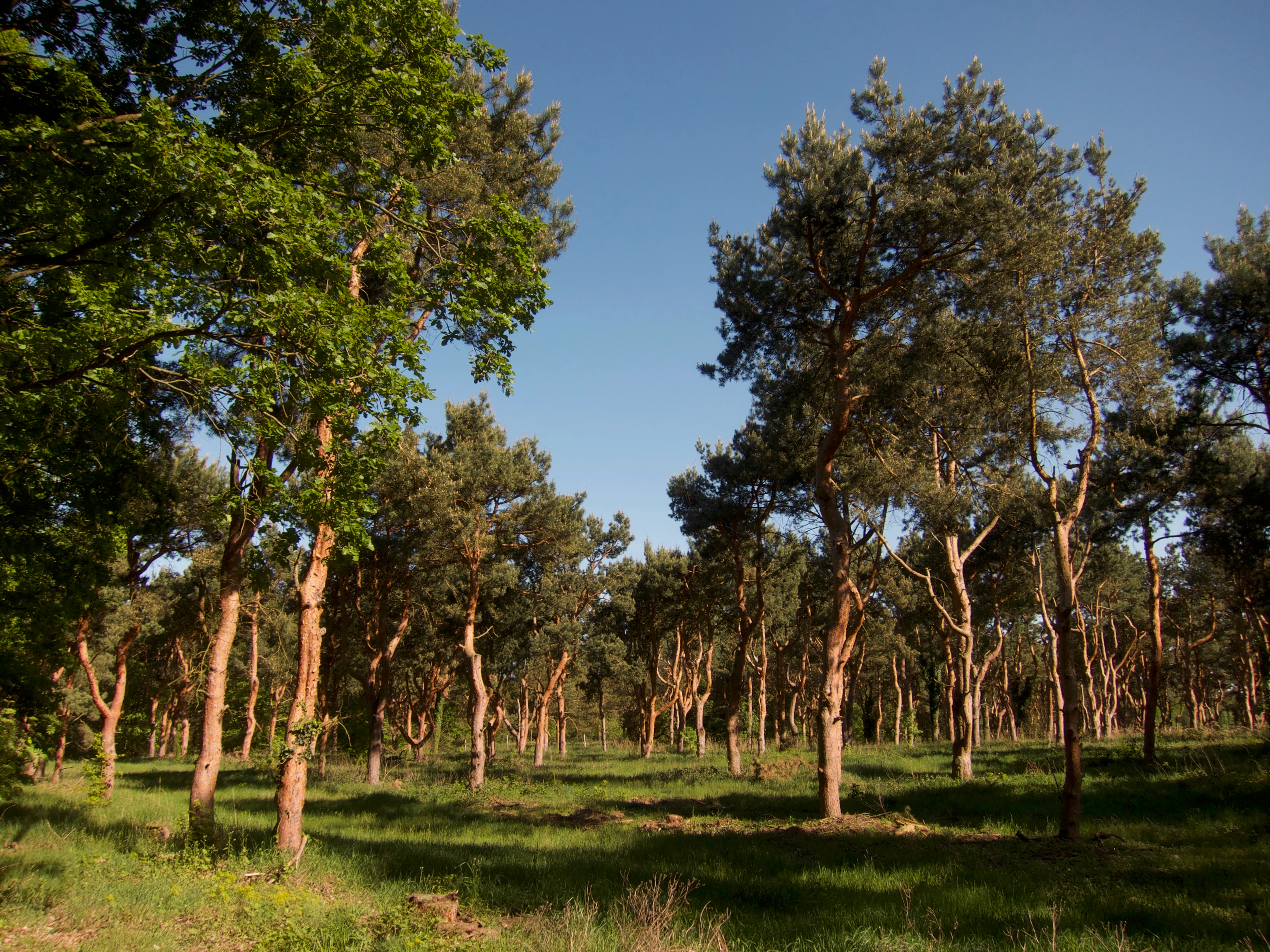
A sunny forest scene featuring thin pine trees with orange-brown bark scattered across a grassy floor under a clear blue sky.
A view of the woodland landscape within the Lehniner Mittelheide.

Lehniner Mittelheide und Quellgebiet der Emster history and protected-area timeline

The reserve has a relatively short but clearly documented institutional history. On 21 May 1996 the responsible authorities of Brandenburg issued a statutory ordinance placing the area under nature protection, formalizing its status as a Naturschutzgebiet. The designation under catalogue number 1509 came into effect formally on 12 October 1996, framing the reserve as part of the broader wave of post-reunification protection efforts across Brandenburg aimed at securing representative examples of the state's natural heritage.

Its inclusion in the World Database on Protected Areas under WDPA-ID 164416 reflects the site's recognition within international frameworks for habitat and species management. The reserve's history is less one of dramatic milestones than of a defined administrative act that set the legal basis for ongoing habitat management in heath and spring landscape on the Kloster Lehnin territory.

Lehniner Mittelheide und Quellgebiet der Emster landscape and geographic character

The landscape of the reserve is shaped by a contrast between drier sandy uplands and the lower-lying spring valley of the Emster. The Mittelheide component gives the area its open, lightly wooded character, with sandy substrates characteristic of the glacial lowlands of northern Brandenburg; these soils support dry heath vegetation and open woodland rather than closed forest.

The Quellgebiet der Emster introduces a markedly different topographic register. Springs rising within the reserve feed the headwaters of the Emster, and along this flow corridor the terrain flattens out into the elongated wet zone known as the Emstaler Schlauch. Standing water bodies such as the Mühlenteich pond and the Mittelsee lake interrupt and punctuate this valley. The Gohlitzsee lies along the western edge of the protected area, while the A 2 motorway traces the northern boundary, and the L 88 road cuts through the interior, providing a sense of how the reserve interfaces with surrounding transport and settlement features.

Lehniner Mittelheide und Quellgebiet der Emster ecosystems, habitats, and plant life

Ecologically, the reserve functions as a meeting point between two complementary habitat worlds. The Lehniner Mittelheide contributes open sandy heath and dry woodland, a habitat type associated with low-nutrient substrates, specialist plant communities, and fauna adapted to semi-open landscapes. This kind of heath mosaic has become scarce across much of Brandenburg due to land-use change and forest succession.

The Quellgebiet der Emster adds spring mires, wet meadows, pond margins, and lake shoreline, creating conditions for moisture-dependent flora and fauna. The Emstaler Schlauch and the associated standing waters, including Mühlenteich and Mittelsee, supply the hydrological backbone that keeps the springs flowing and maintains saturated ground conditions through the year. Together, the dry and wet components form a habitat mosaic that supports a wider spectrum of species than either alone.

Lehniner Mittelheide und Quellgebiet der Emster wildlife and species highlights

The wildlife significance of the reserve lies in the overlap between heath and wetland habitats rather than in any single flagship species. Heathland patches provide nesting and foraging conditions for bird species typical of open and semi-open sandy terrain, while the ponds, lake edges, and spring channels of the upper Emster corridor support amphibians, aquatic invertebrates, and water-associated birdlife.

The combination of dry heath, wet margins, and spring-fed watercourses also sustains invertebrates and small vertebrates that depend on the particular microclimate and vegetation structure found at the interface of these habitat types. The reserve's management under IUCN Category IV reflects an intent to maintain these conditions in the long term, including through interventions designed to keep the heath open and to preserve the hydrology of the spring system.

Lehniner Mittelheide und Quellgebiet der Emster conservation status and protection priorities

From a conservation perspective, the reserve addresses two pressures that often affect Brandenburg's natural landscapes: the loss of open inland heath and the degradation of spring-influenced wetland systems. By integrating both into a single protected area, it helps safeguard habitat diversity at a local scale while contributing to the regional network of protected sites listed among the nature reserves of Potsdam-Mittelmark.

Its IUCN Category IV status, aimed at habitat and species management, indicates that protection here is not solely passive. The designation implies active stewardship to counter forest encroachment on the heath, to maintain the water regime of the springs, and to manage the interplay between Mühlenteich, Mittelsee, and the Emstaler Schlauch. The legal foundation established in 1996, together with the site's registration in the World Database on Protected Areas, gives the reserve a framework that supports continued conservation management.

Lehniner Mittelheide und Quellgebiet der Emster cultural meaning and human context

The reserve sits within the broader cultural landscape of Kloster Lehnin, a municipality whose name recalls the historic Cistercian monastery that has given the surrounding area a recognizable regional identity for centuries. While the reserve itself is defined by ecological rather than cultural criteria, its location along the upper Emster and near the village of Rädel connects it visually and functionally to the traditional rural landscape of this part of Brandenburg.

The pairing of heathland and spring valley also reflects older land-use patterns in the region, where sandy uplands tended to support low-intensity grazing and woodcutting while spring-fed valleys were valued for water supply, pond fisheries, and small-scale mills. The Mühlenteich name, for instance, preserves a reference to historical milling activity associated with the area's waterways.

Top sights and standout views in Lehniner Mittelheide und Quellgebiet der Emster

The strongest points of distinction for Lehniner Mittelheide und Quellgebiet der Emster are its compact combination of inland sandy heath and a spring-dominated headwater valley within a single protected boundary. The presence of recognizable landmarks such as the Mühlenteich, the Mittelsee, and the Emstaler Schlauch gives the reserve a clear geographic identity, while its location between the A 2 corridor, district roads, and the Gohlitzsee makes it a notable example of how protected habitats are embedded in an actively used regional landscape.

Best time to visit Lehniner Mittelheide und Quellgebiet der Emster

Seasonality in the reserve is shaped by its mix of dry heath and spring-fed wetland. Late spring and early summer tend to bring out the flowering and insect activity typical of open heathland, while periods of stable water levels are important for experiencing the full character of the ponds, lake margins, and wet corridor along the Emster. Bird activity associated with both open and wetland habitats is often most noticeable during the warmer months, when the spring sources and standing waters are also at their most biologically active.


Monthly climate preview

Long term representative monthly averages for temperature and precipitation patterns

Lehniner Mittelheide und Quellgebiet der Emster Climate Normals and Annual Temperature Rhythm

Representative coordinates record measured monthly temperature swings from sub-zero winter minimums to warm summer maximums alongside steady precipitation rates. Reviewing the complete twelve-month climatology profile provides deeper analytical depth for this protected regional landscape.
Annual mean9 °C
0 °C20 °C
Jan
Feb
Mar
Apr
May14°
Jun18°
Jul20°
Aug20°
Sep15°
Oct
Nov
Dec
Warmest month
July

19.9 °C

Coolest month
January

-0.4 °C

Wettest month
July

2.4 mm/day

Driest month
April

1.1 mm/day

Park location guide

Geography guide, regional context, and park location map for Lehniner Mittelheide und Quellgebiet der Emster

Lehniner Mittelheide und Quellgebiet der Emster park geography, regions, and map view in Germany

Understand where Lehniner Mittelheide und Quellgebiet der Emster sits in Germany through a broader geographic reading of the surrounding landscape, nearby location context, and its mapped position within the national park landscape.

How Lehniner Mittelheide und Quellgebiet der Emster fits into Germany

Germany is a federal republic in Western and Central Europe with a population of over 83 million across sixteen constituent states. It is Europe's largest economy by nominal GDP and a major global exporter and importer. The capital is Berlin, and the country borders Denmark, Poland, Czech Republic, Austria, Switzerland, France, Luxembourg, Belgium, and the Netherlands.

Wider geography shaping Lehniner Mittelheide und Quellgebiet der Emster in Germany

Germany is located in Western and Central Europe, spanning 357,022 km². It borders Denmark to the north, Poland and the Czech Republic to the east, Austria and Switzerland to the south, and France, Luxembourg, Belgium, and the Netherlands to the west. The country has coastlines on the Baltic Sea and North Sea to the north, with the Alps located in the southern region.

Map view of Lehniner Mittelheide und Quellgebiet der Emster

Use this park location map to pinpoint Lehniner Mittelheide und Quellgebiet der Emster in Germany, understand its exact geographic position, and read its mapped placement within the surrounding landscape more clearly.

Pigeon | © OpenStreetMap contributors

Location context for Lehniner Mittelheide und Quellgebiet der Emster

Brandenburg

Visualizing sandy inland heaths, spring mires, and valley wetland habitats

Lehniner Mittelheide und Quellgebiet der Emster Photos and Protected Landscape Scenery

Photographs capture the striking transition between dry sandy uplands and spring-fed wetland corridors across the protected reserve. Visual documentation reveals the distinct terrain of open heathland patches, valley ponds, and headwater streams defining the regional habitat mosaic.

A sunny forest scene featuring thin pine trees with orange-brown bark scattered across a grassy floor under a clear blue sky.

Park atlas

Compare surrounding Brandenburg nature reserves and regional wetland habitats

Other Protected Areas Near Lehniner Mittelheide und Quellgebiet der Emster

Browsing nearby protected areas allows comparison of sandy heathlands and spring-fed valley systems across the wider regional landscape. Evaluating adjacent conservation sites places the distinct local topography of the Emster catchment into a broader geographical context.
A soft watercolor illustration showing rolling green hills, a small stream winding through the foreground, and distant purple-toned peaks against a white background.
Nature reserveBrandenburg
8.1 km away#1 closest

Northeast

Glindower Alpen: Protected Nature Reserve and Clay Mining Geography in Brandenburg

A striking post-industrial landscape and nature reserve

Glindower Alpen is a 120-hectare nature reserve near Werder, Germany, characterized by an atypical terrain of deep ravines and ridges resulting from historical clay mining. This protected area stands out as an island of mixed deciduous forests and dry grasslands amidst the broader flat geography of the Brandenburg region.

Area
1.19 km²
Established
1995
Relief
Upland
Climate
Temperate
Nature reserveBrandenburg
About 9.9 km away#2 closest

Southwest

Belziger Landschaftswiesen Nature Reserve: Protected Wetland Geography and Glacial Valley Mapping

Regional landscape profile, peatland ecology, and glacial valley terrain

Spanning over 7,000 hectares in the Baruther Urstromtal, the Belziger Landschaftswiesen serves as a vital nature reserve and lowland habitat in Brandenburg. This geography-focused profile traces the wetland's identity as a through-flow peatland, its role in hosting rare meadow birds, and the defining physical edges where the flat valley floor meets the high Fläming ridge.

Area
45 km²
Established
2005
Relief
Lowland
Climate
Temperate
Nature reserveBrandenburg
About 10 km away#3 closest

Northeast

Naturschutzgebiet Krielower See: Protected Nature Reserve and Glacial Wetland Geography

Located in Brandenburg, this reserve protects a complex, silted-up lake basin and wetland network.

Naturschutzgebiet Krielower See protects a distinct glacial landscape near the Havel river. This 155-hectare nature reserve preserves a network of alder carr, reed beds, and wet meadows, providing an essential refuge for diverse species within the broader Havelland natural region. Explore the mapped topography and conservation context of this integral Brandenburg wetland habitat.

Area
1.55 km²
Established
2004
Relief
Lowland
Climate
Temperate
Watercolor painting of a lush, flat landscape with low green hills in the distance and wetland vegetation in the foreground.
Protected landscapeBrandenburg
About 12 km away#4 closest

North

Landschaftsschutzgebiet Brandenburger Osthavelniederung: Protected Landscape and Regional Geography

Mapped Havel River floodplain and glacial moraine terrain in Brandenburg.

Covering over 9,000 hectares, this protected landscape serves as a prime example of the Brandenburg Havel region. The area integrates a network of canals, dikes, and backwater lakes with isolated moraine ridges, creating a diverse geographic mosaic of river-managed lowlands and forested glacial remnants.

Area
93.81 km²
Established
1998
Relief
Lowland
Climate
Temperate
A soft, artistic watercolor painting of a river landscape with trees, grassy banks, and rolling hills in the background.
Nature reserveBrandenburg
About 21 km away#5 closest

Northeast

Falkenrehder Wublitz Nature Reserve: Brandenburg Wetland Geography and Protected Landscape Atlas

A mapped riparian wetland reserve within the Havel valley floodplain.

Falkenrehder Wublitz is a nature reserve in Brandenburg, Germany, established to safeguard a representative slice of the Havel lowland wetlands. Centered on the Wublitz side arm of the Havel river, this protected area features diverse aquatic habitats, wet meadows, and swamp forests. The reserve plays a functional role in regional conservation by linking smaller wetland pockets into a broader, connected riparian landscape near the Havel Canal.

Area
0.976 km²
Established
2002
IUCN
IV
A soft watercolor illustration of a rolling green landscape with a small cluster of trees and birch trees in the foreground, against a pale background.
Nature reserveBrandenburg
23 km away#6 closest

Northeast

Ferbitzer Bruch Nature Reserve: Exploring Brandenburg Protected Landscape Boundaries

A lowland mosaic of sandy habitat in the Havelland region

Ferbitzer Bruch provides a focused look at the sandy lowland ecosystems characteristic of western Brandenburg. This nature reserve, anchored between the Havel Canal and the Döberitzer Heide, preserves a distinct mosaic of open heath, scrub, and woodland habitats that define this segment of the German landscape.

Area
11.564 km²
Established
1996
IUCN
IV
A soft watercolor painting showing rolling green hills, patches of open land, and trees against a pale sky background.
Nature reserveHavelland
23 km away#7 closest

Northeast

Döberitzer Heide Nature Reserve: Geographic Atlas and Protected Landscape Mapping

Glacial sand flats and heathlands in the Havelland region

Döberitzer Heide occupies a unique position on the southeastern Nauener Platte, providing a study of dry heath, grassland, and wetland habitats. Once a restricted military training ground, the area now functions as a vital protected landscape where European bison and wild horses maintain open terrains. This atlas entry focuses on the regional geography and the structural components of this nature reserve situated near the urban centers of Berlin and Potsdam.

Area
34.15 km²
Established
1997
Relief
Upland
Climate
Temperate
A panoramic watercolor illustration showing a meadow with green grasses, pink and purple wildflowers, shrubs, a misty water body, rolling green hills in the background, and a bird flying in a pale yellow sky
Protected landscapeBrandenburg
About 24 km away#8 closest

Southeast

Naturpark Nuthe-Nieplitz: Geographic Overview of a Brandenburg Protected Landscape

Glacial river valleys and rewilded pine forest terrain

Naturpark Nuthe-Nieplitz represents a significant protected area in Brandenburg, Germany, characterized by its interconnected river lowlands and glacial features. The terrain features a rich mix of reed-fringed lakes, alder woodlands, and former military grounds currently undergoing ecological restoration. This overview traces the boundaries and landscape character of the park, providing essential context for its role in regional conservation.

Area
623.23 km²
Established
1999
Relief
Lowland
Climate
Temperate

Common questions about visiting, size, designation, and location context for Lehniner Mittelheide und Quellgebiet der Emster

Lehniner Mittelheide und Quellgebiet der Emster FAQs for park facts, access, geography, and protected area context

Find quick answers about Lehniner Mittelheide und Quellgebiet der Emster, including protected-area facts, park geography, trail and visitor context, and how the park fits into its surrounding country and regional landscape.
MoriAtlas Explorer

Continue Your Protected Areas Search Across the Global Atlas

Deepen your exploration by continuing the structured search for national parks and protected areas worldwide. Utilize the comprehensive filtering capabilities to compare different conservation landscapes and refine your understanding of global park geography. Discover more about the distribution and characteristics of protected natural areas.

Global natural geography