
Mori Atlas logo
Nature reserveLeiberger Wald

Mapping the ecological connectivity between the Sauerland hills and the Paderborner Hochfläche

Leiberger Wald Nature Reserve: A Core Protected Forest Landscape in Nordrhein-Westfalen

(Naturschutzgebiet Leiberger Wald)

Leiberger Wald stands as a vital nature reserve and protected forest complex within the Kreis Paderborn, spanning nearly 1,786 hectares of woodland and stream-fed valleys. This reserve serves as a critical dispersal corridor at the transition between the Sauerland low mountains and the Paderborner Hochfläche, featuring diverse beech forest communities, alder-ash floodplain habitats, and rare calcareous tufa springs. Its geographic position and connectivity make it a foundational element of the regional Natura 2000 network.

beech forestfloodplain forestcalcareous springsforest reserveNatura 2000FFH site
A flat-design, stylized digital illustration of a mountain landscape with a large cliff, a waterfall flowing into a river, evergreen and deciduous trees, and a dirt path splitting in the foreground.

Leiberger Wald

Nature reserve

Park overview

Structured park overview, official facts, and landscape profile for Leiberger Wald

Leiberger Wald park facts, protected area profile, and essential visitor context

Review the core facts for Leiberger Wald, including designation, size, terrain, visitor scale, habitats, and operating context in one park-focused overview.

About Leiberger Wald

Leiberger Wald is a protected forest landscape in the German federal state of North Rhine-Westphalia, situated in the eastern part of the Kreis Paderborn. The reserve spans the municipal territories of Bad Wünnenberg and Büren and falls within a transition zone where the upland character of the Sauerland meets the more open Paderborner Hochfläche. With an area of approximately 1,786 hectares, it is the second largest nature reserve in the district and represents one of the more substantial forest protection areas in this part of western Germany.

The reserve is composed of two separate forested tracts that together form a coherent ecological unit. Much of the area is covered by closed woodland, with smaller open clearings scattered through the canopy. The forest composition is varied: beech woodland dominates large portions of the reserve, including both woodrush beech forest and woodruff beech forest communities, while along streams and wetter ground one finds alder-ash and softwood floodplain forests. At the time of designation some spruce stands were also present. Calcareous tufa springs emerge within the forest, and small flowing waters carry submerged aquatic vegetation, adding further ecological diversity to an otherwise woodland-dominated landscape.

Beyond its habitat value, Leiberger Wald holds a recognised position in Germany's and the European Union's wider conservation framework. Together with the neighbouring Nettetal reserve, it forms the FFH site DE-4517-303 and contributes to the Natura 2000 network. From February 2023 the area became part of the proposed EU bird protection area 'Diemel- und Hoppecketal mit Wäldern bei Brilon und Marsberg', extending its significance to avian conservation as well.

Culturally, the reserve contains the Burganlage im Leiberger Wald, a castle or fortification site that adds a layer of regional historical interest to the otherwise natural landscape. The surrounding area is a recognised regional cultural landscape element, underscoring the long-standing interplay between the forest environment and human settlement in this part of the Paderborn district.

Quick facts and research context for Leiberger Wald

Leiberger Wald is a nature reserve (Naturschutzgebiet) in North Rhine-Westphalia, Germany, identified by the code PB-060 and covering roughly 1,786 hectares across the municipalities of Bad Wünnenberg and Büren in the Kreis Paderborn. It consists of two forested tracts and lies at the transition between the Sauerland and the Paderborn plateau. The reserve is part of the FFH site DE-4517-303 and is linked to the EU Natura 2000 network.

IUCN management category IV applies, indicating a habitat and species management area with active forestry restrictions. The protected landscape includes beech forest communities, alder-ash floodplain woodland, calcareous tufa springs, and small streams, and adjoins the Aabachsee reservoir to the east.

Protection and recognition

Documented conservation status, designations, and international recognition sources

Leiberger Wald Protection Status and Official International Recognition Data

Leiberger Wald maintains documented protection records including official Natura 2000 designations and database registry listings. Regional conservation frameworks and formal recognition sources establish the administrative standing of the protected area.
Park context

Deeper park guide and search-rich context for Leiberger Wald

Leiberger Wald history, landscape, wildlife, and travel context

Explore Leiberger Wald through its history, landscape character, ecosystems, wildlife, conservation priorities, cultural context, and seasonal travel timing in a structured park guide built for atlas discovery and search intent.

Why Leiberger Wald stands out

Leiberger Wald is best known as one of the largest contiguous forest reserves in the Kreis Paderborn, recognised for combining several FFH-relevant woodland habitat types in a single connected complex. The reserve is particularly valued for its beech forest communities, including woodrush beech forest and woodruff beech forest, alongside alder-ash and softwood floodplain forests along small watercourses. Its role as a refuge and dispersal space for forest and stream-dependent species is another defining feature. The reserve supports a community of rare breeding birds, the wildcat in the forest interior, and the bullhead in cold, structured streams, reflecting its importance for woodland-stream ecosystems at the Sauerland / Paderborn plateau transition.
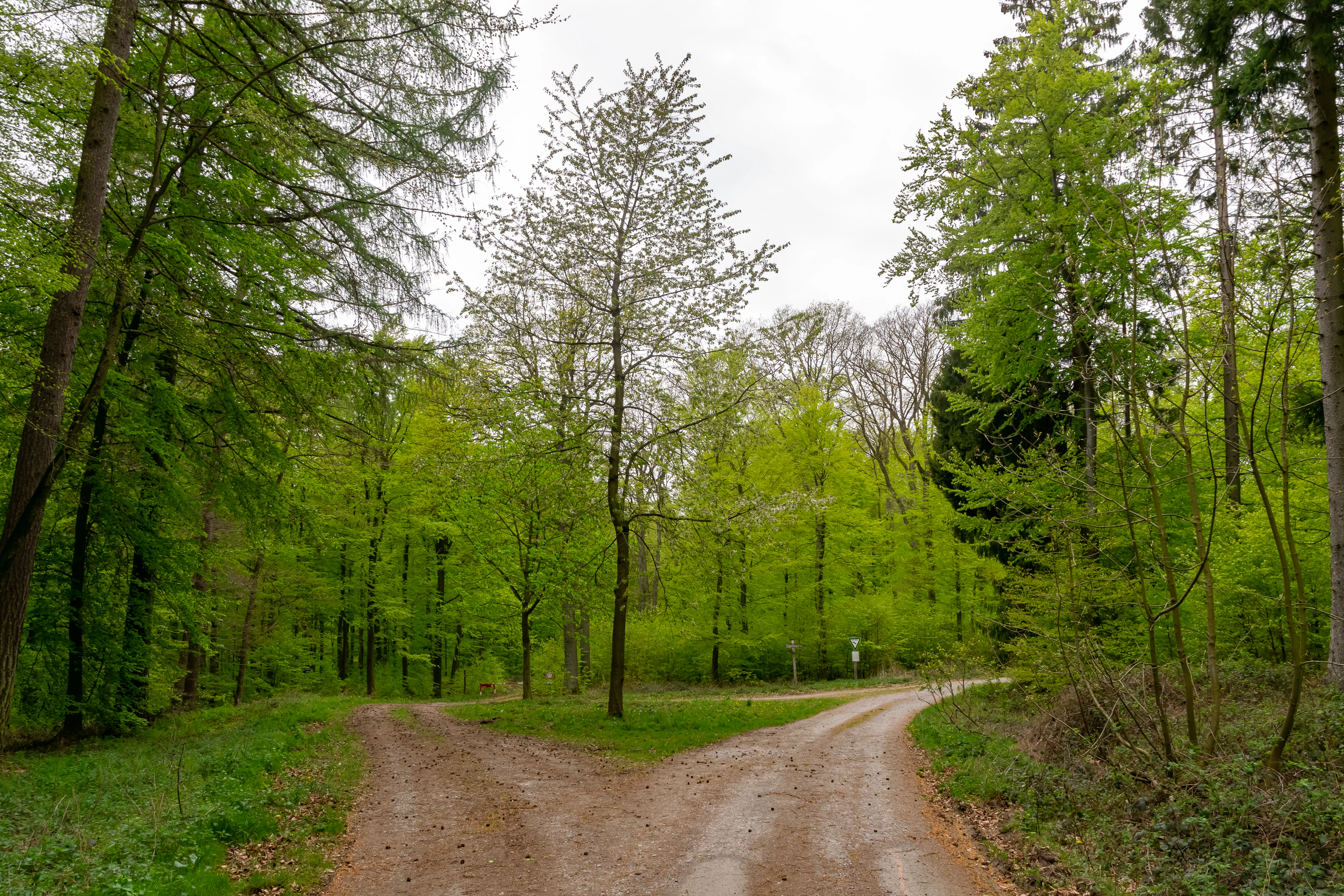
A fork in a gravel forest trail surrounded by vibrant green deciduous trees in spring.
A fork in a dirt path winding through the lush forest of Leiberger Wald.

Leiberger Wald history and protected-area timeline

The protection of Leiberger Wald began in 1994, when the area was provisionally designated through the Büren-Wünnenberg landscape plan (Landschaftsplan Büren-Wünnenberg). In 1996, the Kreistag of the Kreis Paderborn formally confirmed the area as a Naturschutzgebiet, giving it the protected code PB-060.

Since its designation, the reserve has been embedded in progressively larger conservation frameworks. It has been recognised within the European Natura 2000 system through the FFH site DE-4517-303 and was incorporated in 2023 into the proposed EU bird protection area covering woodland and valley systems around Brilon and Marsberg. Forest management within the reserve is subject to additional restrictions beyond standard forestry rules, reflecting the area's importance for habitat and species protection.

Leiberger Wald landscape and geographic character

Leiberger Wald lies at the geographic transition between the forested hills of the Sauerland and the more open Paderborner Hochfläche, giving the reserve a varied topography shaped by gentle valleys, woodland slopes, and small flowing waters. The two protected tracts together form a largely continuous wooded landscape, with only occasional open clearings interrupting the canopy.

The hydrology of the area shapes much of its character. The river Alme, a left tributary of the Lippe, flows along the southeastern edge of the reserve, while the Aabachsee reservoir lies just to the east. Inside the forest, small streams with submerged aquatic vegetation and calcareous tufa springs contribute to a moist, structurally varied woodland landscape. Several roads frame and cross the area, including the B 480 federal road that runs through the reserve and the L 637, L 956, and L 549 district roads along its edges, integrating the forest into the wider rural transport network of the district.

Leiberger Wald ecosystems, habitats, and plant life

The ecological character of Leiberger Wald is dominated by forest, with a careful balance between dry upland woodland and wetter streamside habitats. Beech woodland forms the backbone of the reserve, represented both by woodrush beech forest on more acidic soils and by woodruff beech forest on richer ground. These communities create extensive, structurally mature stands that support woodland-interior species.

Along the streams and on valley ground, alder-ash forests and softwood floodplain forests add a contrasting riparian element, while the calcareous tufa springs create specialised micro-habitats within the wider forest. The combination of mature beech forest, floodplain woodland, and spring-fed streams gives the reserve a layered ecological structure unusual for an area of this size, and it is this mixture that underpins its FFH designation and its value as a refuge and dispersal corridor for woodland biodiversity.

Leiberger Wald wildlife and species highlights

The wildlife of Leiberger Wald reflects its largely forested character and the presence of small, clean streams within the reserve. The wildcat occurs in the forest, using the connected woodland complex as both refuge and hunting ground. In the brooks, the bullhead, a small freshwater fish associated with structured, well-oxygenated streams, finds suitable habitat.

The reserve is also notable for its breeding bird community, which includes several rare or sensitive woodland species. Black stork, red kite, goshawk, sparrowhawk, common kestrel, tawny owl, middle spotted woodpecker, black woodpecker, and grey-headed woodpecker are all recorded, indicating a structurally rich forest interior with mature trees, dead wood, and open foraging areas nearby. Together, these species underline the reserve's significance for forest and forest-edge fauna in the transition between the Sauerland and the Paderborn plateau.

Leiberger Wald conservation status and protection priorities

Leiberger Wald is designated as a Naturschutzgebiet under German federal and state nature conservation law and falls within IUCN management category IV, a habitat and species management area. Its conservation value lies in the regionally important combination of FFH-relevant habitat types within a single large, connected forest complex.

The landscape plan describes the area as an important refuge and dispersal space for numerous animal and plant species of forest ecosystems at the Sauerland / Paderborn plateau transition, and as a key element of the regional biotope network. Beyond the national designation, the reserve forms part of the FFH site DE-4517-303 together with the neighbouring Nettetal reserve, placing it within the European Natura 2000 network. From 2023 it has also been integrated into the proposed EU bird protection area 'Diemel- und Hoppecketal mit Wäldern bei Brilon und Marsberg', extending its protected status to breeding and migratory birds.

Forestry within the reserve is subject to additional restrictions and special provisions beyond ordinary forest management, designed to protect sensitive habitats, preserve dead wood and old-growth structure, and maintain the integrity of streams and springs.

Leiberger Wald cultural meaning and human context

The Leiberger Wald is more than a purely natural landscape: it is recognised as a regionally significant cultural landscape element (Kulturlandschaftsbereich K 16.14) by the Landschaftsverband Westfalen-Lippe, reflecting centuries of human interaction with the forest environment. Within the reserve stands the Burganlage im Leiberger Wald, a historic fortification site that adds a tangible layer of regional history to the protected woodland.

The reserve lies in a rural setting between the towns of Bad Wünnenberg and Büren, where small-scale agriculture, forestry, and traditional settlement have long shaped the relationship between people and forest. This combination of ecological protection and recognition as a cultural landscape gives Leiberger Wald a dual identity as both a natural heritage site and a carrier of regional historical memory.

Top sights and standout views in Leiberger Wald

Among the most distinctive qualities of Leiberger Wald is its sheer scale within the Kreis Paderborn: as the second largest nature reserve in the district, it provides one of the most extensive contiguous forest protection areas in this part of North Rhine-Westphalia. The combination of woodrush and woodruff beech forest communities alongside alder-ash and softwood floodplain forests creates an unusually layered woodland habitat.

The presence of calcareous tufa springs and structured, vegetation-rich streams further enhances the reserve's ecological profile, while species such as the wildcat, bullhead, black stork, and several rare woodpeckers confirm its importance for forest and freshwater fauna. Layered European designations, including the FFH site DE-4517-303 and the 2023 EU bird protection area extension, make it a meaningful node in the broader Natura 2000 network of western Germany.

Best time to visit Leiberger Wald

As a forested nature reserve without developed visitor infrastructure in the usual sense, Leiberger Wald is most rewarding for visitors interested in quiet woodland landscapes. Late spring and early summer tend to highlight the fresh green of the beech canopy and the activity of breeding birds, while autumn brings a pronounced seasonal palette across the mixed forest and a more visible presence of woodland fauna. Cold, clear winter days can also suit visits focused on landscape structure, stream corridors, and the historical castle site within the reserve.

Monthly climate preview

Long-term representative point measurements tracking monthly temperature and precipitation patterns

Leiberger Wald Climate Normals, Annual Temperature and Precipitation Rhythm

Leiberger Wald records measured mean temperatures ranging from negative values in winter months up to nearly eighteen degrees Celsius in peak periods alongside steady daily precipitation rates. Examining the full twelve-month climate profile reveals comprehensive statistical breakdowns for average minimum and maximum thresholds across the protected terrain.
Annual mean9 °C
0 °C18 °C
Jan
Feb
Mar
Apr
May12°
Jun15°
Jul18°
Aug18°
Sep14°
Oct
Nov
Dec
Warmest month
July

18 °C

Coolest month
January

-0.2 °C

Wettest month
July

2.6 mm/day

Driest month
April

1.7 mm/day

Park location guide

Geography guide, regional context, and park location map for Leiberger Wald

Leiberger Wald park geography, regions, and map view in Germany

Understand where Leiberger Wald sits in Germany through a broader geographic reading of the surrounding landscape, nearby location context, and its mapped position within the national park landscape.

How Leiberger Wald fits into Germany

Germany is a federal republic in Western and Central Europe with a population of over 83 million across sixteen constituent states. It is Europe's largest economy by nominal GDP and a major global exporter and importer. The capital is Berlin, and the country borders Denmark, Poland, Czech Republic, Austria, Switzerland, France, Luxembourg, Belgium, and the Netherlands.

Wider geography shaping Leiberger Wald in Germany

Germany is located in Western and Central Europe, spanning 357,022 km². It borders Denmark to the north, Poland and the Czech Republic to the east, Austria and Switzerland to the south, and France, Luxembourg, Belgium, and the Netherlands to the west. The country has coastlines on the Baltic Sea and North Sea to the north, with the Alps located in the southern region.

Map view of Leiberger Wald

Use this park location map to pinpoint Leiberger Wald in Germany, understand its exact geographic position, and read its mapped placement within the surrounding landscape more clearly.

Pigeon | © OpenStreetMap contributors

Location context for Leiberger Wald

Nordrhein-Westfalen
Recorded earthquake history

Review the Historical Earthquake Catalogue for Leiberger Wald

Examine the documented record of seismic events associated with the geography of Leiberger Wald. MoriAtlas provides a clear, filterable archive of historical earthquake data to support regional analysis and contextual landscape exploration.

Leiberger Wald Earthquake History

Catalogued events

1 event

Strongest magnitude

Magnitude 3

Most recent event

Jun 28, 1996

This history includes earthquakes recorded inside the park or within 50 km of its borders

Explore protected area photography, woodland terrain, and regional nature reserve views.

Leiberger Wald Photos and Scenery: Visualizing Forest Landscapes and Habitats

Examine detailed visual records of Leiberger Wald to understand its closed forest tracts, valley slopes, and river margins. Photographic documentation reveals the underlying protected terrain, woodland composition, and regional ecological features.

A fork in a gravel forest trail surrounded by vibrant green deciduous trees in spring.

Park atlas

Compare regional forest reserves and connected protected areas across the Paderborn plateau.

Other Parks Near Leiberger Wald and Surrounding Protected Landscapes

Browse neighbouring protected areas and connected forest reserves located near Leiberger Wald across western Germany. Expanding the geographic scope reveals broader regional woodland networks and comparative terrain features.
A watercolor landscape illustration showing gentle green hills, clusters of trees, and soft pink and yellow clouds in the background.
Nature reserveNordrhein-Westfalen
About 1 km away#1 closest

Southwest

Naturschutzgebiet Almetal: Landscape Geography and Protected Nature Reserve Mapping

A diverse river valley corridor in North Rhine-Westphalia

Naturschutzgebiet Almetal protects a narrow, structurally varied floodplain along the Alme river. The area is defined by its contrast between open wet meadows, alder woodland, and forested uplands, forming an essential ecological link within the Sauerland region of North Rhine-Westphalia.

Area
0.938 km²
Established
2008
IUCN
IV
Relief
Lowland
A horizontal watercolor illustration of a soft, hazy valley with rolling green hills, distant treelines, and wildflowers in the foreground.
Nature reserveNorth Rhine-Westphalia
About 4.1 km away#2 closest

Southeast

Naturschutzgebiet Aabachtal Nature Reserve and Sauerland Protected Stream Valley Geography

A preserved fluvial landscape in North Rhine-Westphalia

Naturschutzgebiet Aabachtal is a protected nature reserve in the northern Sauerland of North Rhine-Westphalia. Centered on the Aabach stream, it protects a classic Mittelgebirge valley landscape defined by meandering watercourses, lush floodplain meadows, and deciduous forest slopes, serving as a critical habitat for specialized moisture-loving flora and diverse riparian fauna.

Area
0.716 km²
Established
2001
Relief
Upland
Scope
Terrestrial
A horizontal watercolor painting of a calm lake surrounded by a pine forest and rolling hills under a soft light.
Protected landscapeKreis Paderborn
About 4.7 km away#3 closest

East

Landschaftsschutzgebiet FFH-Gebiet Fürstenberger Wald: Protected Area and Forest Geography

A woodland conservation landscape in the Kreis Paderborn foothills

This protected area features a cohesive block of old-growth beech forest, enriched by significant deadwood habitats and a dense internal network of brooks. Located within the Kreis Paderborn administrative district, the landscape serves as a key ecological connector in the eastern Sauerland, balancing moist valley meadows with upland forest ridges and ongoing deciduous forest restoration efforts.

Area
14.925 km²
Established
2007
Relief
Upland
Climate
Temperate
A horizontal watercolor painting showing a green valley with a winding river, rolling hills in the background, and grassy foreground.
Nature reserveNordrhein-Westfalen
About 5.8 km away#4 closest

Southwest

Naturschutzgebiet Oberes Möhnetal: Protected Floodplain and River Corridor Geography

A restored riparian landscape in Nordrhein-Westfalen

Located in the Sauerland, Naturschutzgebiet Oberes Möhnetal preserves an 81-hectare floodplain characterized by its successful LIFE+ river restoration. The area features a complex transition from meandered stream channels to wet meadows and alluvial woodlands, illustrating process-based conservation within the regional Natura 2000 corridor.

Area
0.812 km²
Established
2008
Protected landscapeKreis Paderborn
About 5.9 km away#5 closest

North

Landschaftsschutzgebiet FFH-Gebiet Wälder bei Büren: Regional Protected Forest Landscapes

Geographic map and protected area context in Kreis Paderborn

Landschaftsschutzgebiet FFH-Gebiet Wälder bei Büren functions as a European-level habitat site defined by its interconnected beech forest mosaic. The area is characterized by a mix of woodruff and rough blue-grass beech woodland, interwoven with intermittent stream courses, source areas, and geological sinkholes that create varied microhabitats within the North Rhine-Westphalia landscape.

Area
28.045 km²
Established
2007
Relief
Upland
Climate
Temperate
A wide watercolor-style illustration of a soft landscape featuring rolling green hills, scattered forest patches, and pale pink mountains in the background with a light sky.
Nature reserveNorth Rhine-Westphalia
About 6.8 km away#6 closest

South

Hollenloch Nature Reserve: Karst Cave Systems and Protected Limestone Woodland Geography

Exploration of subterranean geology and regional karst habitats

Hollenloch stands as one of the longest and deepest cave systems within the Sauerland, developed inside dense Upper Devonian reef limestone. This protected site integrates surface karst features like the Schwalgloch with specialized forest ecosystems, providing a vital subterranean refuge for diverse bat species and a rich record of prehistoric human activity.

Area
0.032 km²
Established
2001
Relief
Upland
Climate
Temperate
A watercolor painting showing a soft, peaceful landscape with a small body of water in the foreground, surrounded by grassy banks and low hills in the distance.
Nature reserveHochsauerlandkreis
About 7.9 km away#7 closest

South

Naturschutzgebiet Schwarzes Haupt: A Protected Limestone Landscape in Hochsauerlandkreis

Mapped calcareous grasslands and orchid-rich beech forests.

This nature reserve covers 9.8 hectares of the Schwarze Haupt hill, featuring a layered terrain of rocky outcrops, former quarry remnants, and rare grassland habitats. It serves as a critical site for regional biodiversity, linking calcareous ecosystems within the eastern Sauerland through its specialized beech forests and limestone cliff formations.

Area
0.098 km²
Established
2008
Relief
Upland
Scope
Terrestrial
A wide, pale watercolor illustration showing rolling green and yellow hills with scattered trees.
Nature reserveHochsauerlandkreis
About 8.7 km away#8 closest

South

Naturschutzgebiet Scheffelberg / Kalberstert: Mapped Limestone Hill Landscape

Nature reserve located within the Hochsauerlandkreis regional geography

Analyze the topographic features of the Naturschutzgebiet Scheffelberg / Kalberstert, including its conical rock outcrops and expansive dry grasslands. This protected area offers a clear look at the limestone hill systems defining this part of Hochsauerlandkreis, highlighting the intersection of beech woodland and open rocky terrain through detailed geographic mapping.

Area
0.456 km²
Established
2008
Relief
Upland
Climate
Temperate

Common questions about visiting, size, designation, and location context for Leiberger Wald

Leiberger Wald FAQs for park facts, access, geography, and protected area context

Find quick answers about Leiberger Wald, including protected-area facts, park geography, trail and visitor context, and how the park fits into its surrounding country and regional landscape.
MoriAtlas Explorer

Continue Your Protected Areas Search Across the Global Atlas

Deepen your exploration by continuing the structured search for national parks and protected areas worldwide. Utilize the comprehensive filtering capabilities to compare different conservation landscapes and refine your understanding of global park geography. Discover more about the distribution and characteristics of protected natural areas.

Global natural geography