

Mori Atlas logo
National parkLincoln National Park

Discover the mapped boundaries and regional terrain of this national park in South Australia.

Lincoln National Park: Protected Area Atlas and Geographic Landscape Context in South Australia

Lincoln National Park stands as a significant protected area within the broader geography of South Australia. This page provides users with detailed insights into the park's mapped boundaries, helping to understand its protected landscape identity. Explore how Lincoln National Park fits into the regional atlas, offering a focused view of its natural terrain and geographic context for structured discovery.

Coastal national parksIsland ecosystemsMallee woodlandsLimestone cliffsSand dunesWhale migration

Lincoln National Park

National park

Park overview

Structured park overview, official facts, and landscape profile for Lincoln National Park

Lincoln National Park park facts, protected area profile, and essential visitor context
Review the core facts for Lincoln National Park, including designation, size, terrain, visitor scale, habitats, and operating context in one park-focused overview.

About Lincoln National Park

Lincoln National Park occupies the majority of the Jussieu Peninsula, a detached landform connected to the Eyre Peninsula mainland by a narrow isthmus. The park's geography is defined by its elongated northern coastline curving toward Cape Donington, which marks the southern entrance to Port Lincoln's deep, sheltered harbour. The eastern coastline along Spencer Gulf extends from Cape Donington to Taylor's Landing opposite Taylor Island, while the southern boundary traces from Mary Ellis Wreck Beach westward to Jussieu Bay. This southern coastline presents the park's most dramatic terrain, with exposed sand dunes behind Sleaford Bay giving way to formidable limestone cliffs guarding Jussieu Bay. The waters surrounding the peninsula are known for their roughness and dangerous rips, contributing to the area's wilderness character and historical incidents including the 1907 wreck of the ketch Mary Ellis. Beyond the mainland, the park protects a constellation of islands including the Bicker Isles and Horse Rock in Port Lincoln, Rabbit Island, Donington Island, Owen Island and others in Spencer Gulf, and more remote islands including Liguanea Island and Albatross Island near Thistle Island in the Great Australian Bight. The park is classified as an IUCN Category II protected area and is managed by South Australia's Department for Environment and Water.

Quick facts and research context for Lincoln National Park

Lincoln National Park covers 216.38 square kilometres on South Australia's Eyre Peninsula, protecting the majority of the Jussieu Peninsula and over a dozen offshore islands. The park features a diverse coastline transitioning from sweeping sand dunes along Sleaford Bay to rugged limestone cliffs at Jussieu Bay, with the eastern shore facing Spencer Gulf. The landscape supports coastal mallee eucalypt woodlands around granite outcrops, with vegetation becoming sparser on the exposed southern dune systems. The park contains over 100 kilometres of walking trails forming part of the regional Investigator Trail network. The Cape Donington Lighthouse, a 32-metre hexagonal concrete tower built in 1905, remains operational and marks the southern entrance to Port Lincoln harbour.

Park context

Deeper park guide and search-rich context for Lincoln National Park

Lincoln National Park history, landscape, wildlife, and travel context
Explore Lincoln National Park through its history, landscape character, ecosystems, wildlife, conservation priorities, cultural context, and seasonal travel timing in a structured park guide built for atlas discovery and search intent.

Why Lincoln National Park stands out

Lincoln National Park is best known for its dramatic coastal landscapes combining towering limestone cliffs at Wanna and Jussieu Bay with extensive sand dune systems along Sleaford Bay, creating one of South Australia's most visually striking peninsula wilderness areas. The park is distinguished by its island ecosystem component, protecting numerous islands in Port Lincoln and Spencer Gulf that support significant seabird colonies and marine mammal populations. The area holds particular importance for migratory bird species including red-necked stints and sandpipers that travel from the Arctic Circle and Siberia to spend the southern hemisphere summer in the park. Southern right whales can be observed in the surrounding waters between July and November during their seasonal migration along the southern Australian coast.

Lincoln National Park history and protected-area timeline

Lincoln National Park's formal protection began on 28 August 1941 when land in sections 2, 5, 6, and 13 of the Hundred of Flinders was dedicated as a Flora and Fauna Reserve under the Crown Lands Act 1929. On 9 November 1967, these lands and additional sections were proclaimed as Lincoln National Park under the National Parks Act 1966. The park was reconstituted under the National Parks and Wildlife Act 1972 on 27 April 1972, formally incorporating numerous islands including Smith Island, Hopkins Island, Lewis Island, Little Island, Owen Island, Albatross Island, Liguanea Island, and Rabbit Island. Between 1972 and 1992, the park significantly expanded through additions at Stamford Hill, Cape Donington, Wanna, and many coastal islands. The Stamford Hill area holds particular historical significance, with its original Barngarla name being Gaidyaba. In 1993, the Lincoln Conservation Reserve was added to the park's management regime before being declared as the Lincoln Conservation Park. A boundary extension in June 1999 extended protection down to mean low water mark. In 2004, Memory Cove and several islands were excised to form the separate Memory Cove Wilderness Protection Area under the Wilderness Protection Act 1992.

Lincoln National Park landscape and geographic character

The physical landscape of Lincoln National Park presents a compelling combination of coastal geomorphology and exposed peninsula terrain. The Jussieu Peninsula itself is a distinct landform separated from the Eyre Peninsula mainland by a narrow isthmus where the Sleaford Mere Conservation Park abuts the park's western border. The northern coastline sweeps in a broad curve toward Cape Donington, the peninsula's northernmost point and site of the operational Cape Donington Lighthouse. This coast faces onto the protected waters of Port Lincoln harbour. The eastern coastline along Spencer Gulf presents a more exposed character, extending from Cape Donington past Donington Island and multiple small coves to Taylor's Landing opposite Taylor Island. The southern coastline represents the park's most spectacular terrain, where extensive sand dunes rise behind Sleaford Bay creating a dune landscape accessible via the Sleaford to Wanna four-wheel drive track. These dunes give way eastward to the dramatic limestone cliffs that guard Jussieu Bay, a rugged and visually striking section of coastline exposed to the full force of the Southern Ocean. The park's island components add further landscape diversity, from the relatively sheltered islands in Port Lincoln to the more remote and exposed islands in the Great Australian Bight.

Lincoln National Park ecosystems, habitats, and plant life

The ecological character of Lincoln National Park reflects the transition between South Australia's coastal mallee landscapes and the unique island ecosystems of Spencer Gulf and the Great Australian Bight. The mainland portions of the park are largely covered by coastal mallee eucalypt woodlands growing in association with scattered granite outcrops that punctuate the landscape. This mallee vegetation, characterized by multi-stemmed eucalypts adapted to the semi-arid coastal conditions, provides the dominant vegetation framework across the peninsula. The sand dune systems along the southern coastline support a more sparse shrub coverage adapted to the mobile, exposed dune substrate. The granite outcrops scattered throughout the park create microhabitats supporting specialized plant communities. The islands within the park protect additional habitat types including rocky shore communities, seabird nesting areas, and marine environments supporting various species. The waters surrounding the park, particularly Spencer Gulf, host important marine ecosystems including seagrass communities and support the migratory movements of marine mammals.

Lincoln National Park wildlife and species highlights

Lincoln National Park supports a diverse terrestrial and marine fauna assemblage reflecting its position at the junction of several ecological regions. The park is home to substantial populations of kangaroos, wallabies, and emus that inhabit the mallee and woodland areas throughout the peninsula. Historical concerns about feral fox predation on native wildlife have been addressed through extensive baiting and culling programs, and the reduction in fox numbers has allowed notable rebounds in goanna and bush stone curlew populations. The park has also been the site of successful reintroductions of brush-tailed bettongs and malleefowl, both threatened species that are now becoming increasingly common within the park boundaries. The avifauna of the park is particularly significant, with numerous resident species complemented by migratory birds that travel to the area for the southern hemisphere summer. Red-necked stints and sandpipers undertake remarkable journeys from the Arctic Circle and Siberia to spend the warmer months in the park. The marine environment supports southern right whales during their seasonal migrations between July and November, and Australian sea lions can be observed resting on rocks and small islands along the coast.

Lincoln National Park conservation status and protection priorities

Lincoln National Park represents an important protected area within South Australia's coastal conservation estate, classified as an IUCN Category II national park reflecting its primary purpose of ecosystem conservation and protection. The park conserves a representative sample of the Eyre Peninsula's coastal mallee ecosystems while also protecting significant island habitats that would otherwise lack formal protection. The park's heritage values extend beyond natural systems to include indigenous cultural sites with evidence of Barngarla and Nauo occupation spanning thousands of years, as well as early European exploration and settlement history. The management of the park has evolved to address threats including invasive species, with the successful fox control program demonstrating measurable conservation outcomes through native species recovery. The marine environment surrounding the peninsula, including the waters of Spencer Gulf and the Great Australian Bight, receives indirect protection through the park's coastal boundary extension to mean low water mark, supporting the broader marine ecosystem that includes migratory whale corridors and seabird feeding grounds.

Lincoln National Park cultural meaning and human context

The cultural context of Lincoln National Park encompasses a significant timeline of human interaction with the Jussieu Peninsula landscape. The Barngarla and Nauo Aboriginal peoples were the original inhabitants of the region, leaving archaeological evidence throughout the national park including stone working sites, fish trap installations, and shell middens that attest to long-term coastal resource use. Following European discovery by Matthew Flinders in 1802, the peninsula acquired names reflecting this colonial encounter, with Cape Donington named after Flinders' birthplace. An obelisk monument at Stamford Hill, dedicated in 1844 by Sir John Franklin, commemorates Flinders' achievements and is listed on the South Australian Heritage Register. Early European settlement concentrated around Cape Donington where the first grain crop was sown in 1875, supported by woodcutting, grazing, and guano mining industries. The Donington Cottage from this era still stands and is accessible to the public. The 1907 wreck of the ketch Mary Ellis on Sleaford Bay, despite the vessel's total destruction, resulted in no casualties and left Mary Ellis Wreck Beach as a named historical site within the park.

Top sights and standout views in Lincoln National Park

The standout features of Lincoln National Park include the spectacular coastal contrasts between Sleaford Bay's sweeping sand dunes and the rugged limestone cliffs of Jussieu Bay, the extensive trail network offering over 100 kilometres of walking through diverse terrain, and the park's island wilderness component protecting critical seabird and marine mammal habitat. The Cape Donington Lighthouse provides both a navigational landmark and historical perspective on the peninsula's maritime significance. The park's multi-layered heritage combining indigenous Barngarla and Nauo sites, Flinders' exploration legacy, and 19th-century settlement artifacts creates a nuanced cultural landscape. Marine wildlife viewing opportunities, particularly southern right whale migrations from July to November and year-round Australian sea lion presence, add another dimension to the park's appeal. The successful recovery of threatened species including brush-tailed bettongs and malleefowl through reintroduction programs demonstrates active conservation management.

Best time to visit Lincoln National Park

The optimal time to visit Lincoln National Park depends on the experience sought, with the southern hemisphere summer months from December to February offering the warmest conditions for beach activities and camping, though this coincides with the peak period for dangerous rips and rough seas along the exposed southern coastline. The winter months from June to August provide milder conditions for bushwalking and wildlife observation, though some tracks may be affected by wet conditions. Whale watching for southern right whales is best from July through November when these majestic creatures pass through the surrounding waters during their annual migration. The shoulder seasons of spring and autumn offer balanced conditions for walking and outdoor activities, with wildflower displays in spring adding natural colour to the mallee landscapes. Visitors planning activities on the southern beaches should always check current conditions and heed safety warnings given the known dangers of the area's rips and currents.
Park location guide

Geography guide, regional context, and park location map for Lincoln National Park

Lincoln National Park park geography, regions, and map view in Australia
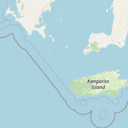
Understand where Lincoln National Park sits in Australia through a broader geographic reading of the surrounding landscape, nearby location context, and its mapped position within the national park landscape.

How Lincoln National Park fits into Australia

Australia is a constitutional monarchy and federal parliamentary democracy comprising six states and ten territories. With a population of nearly 28 million, it is one of the world's most urbanised countries, with most people concentrated on the eastern seaboard. The country has a high Human Development Index and is known for its cultural diversity, ancient Aboriginal heritage, and unique wildlife.

Wider geography shaping Lincoln National Park in Australia

Australia occupies the entire Australian continent, the island of Tasmania, and numerous smaller islands. It is the world's flattest and driest inhabited continent, featuring vast deserts in the interior (the Outback), tropical rainforests along the eastern coast, and a coastline bordering the Indian and Pacific Oceans.

Map view of Lincoln National Park

Use this park location map to pinpoint Lincoln National Park in Australia, understand its exact geographic position, and read its mapped placement within the surrounding landscape more clearly.

Pigeon | © OpenStreetMap contributors

Location context for Lincoln National Park

South Australia
Park atlas

Trace the regional geography of protected areas, comparing coastal wilderness and island ecosystems throughout the Eyre Peninsula.

Discover Other National Parks and Coastal Protected Areas Near Lincoln National Park, Eyre Peninsula
Browse other national parks and protected areas near Lincoln National Park, encompassing coastal wilderness, diverse mallee woodlands, and significant island ecosystems on the Eyre Peninsula. Compare their unique geographic features, trace patterns of conservation landscapes in South Australia, and discover adjacent natural environments beyond one specific park's boundaries.
National parkSouth Australia

Coffin Bay National Park: Protected Landscape and Geographic Context in South Australia

Explore the mapped boundaries and regional geography of this national park.

Coffin Bay National Park presents a distinct protected landscape within South Australia, offering a valuable point of entry for geographic discovery. This page details the park's national park designation and its mapped territory, crucial for understanding its role in Australia's atlas of natural areas. Delve into the park's specific geographic context and the outlines of its protected lands, providing a clear picture of its landscape within the state's broader terrain.

Area
309.76 km²
Established
1982
IUCN
II
Relief
Lowland
National parkSouth Australia

Flinders Chase National Park: A Detailed National Park Entry for Map Exploration in South Australia

Explore mapped boundaries and regional geographic context.

This dedicated entry for Flinders Chase National Park provides critical geographic and protected-area data, functioning as a key point within the MoriAtlas for understanding Australia's conservation landscapes. Investigate the specific mapped boundaries of this national park, situate it within the regional geography of South Australia, and grasp its identity as a distinct protected land. The information here supports structured exploration for anyone seeking detailed atlas context on natural park entities.

Area
326.61 km²
Established
1972
IUCN
II
Relief
Upland
National parkSouth Australia

Deep Creek National Park: Protected Coastal Terrain and Geographic Context in South Australia

Discover South Australia's largest remaining natural vegetation area.

Deep Creek National Park offers a unique protected landscape on South Australia's Fleurieu Peninsula, extending 18 kilometers along the rugged coast. This national park is renowned for its rolling hills, gullies, and dramatic views across Backstairs Passage to Kangaroo Island. It serves as a crucial conservation area, preserving the largest continuous segment of natural vegetation in a region largely transformed by development, making its geography and protected status highly significant.

Area
44.96 km²
Established
1971
IUCN
II
Relief
Mixed relief
National parkSouth Australia

Onkaparinga River National Park: National Park Protected Landscape in South Australia

Explore mapped boundaries and regional geographic context.

Onkaparinga River National Park is a designated national park within South Australia, offering a focused point for understanding protected landscapes. This entry provides detailed geographic context, highlighting the park's mapped boundaries and its place within the regional atlas. Engage with the specific geography and protected-area identity of Onkaparinga River National Park to enhance your landscape exploration.

Area
15.42 km²
Established
1993
IUCN
II
Relief
Upland
National parkSouth Australia

Belair National Park National Park: South Australia Protected Landscape and Map Exploration

Explore the geographic context and mapped boundaries of this South Australian protected area.

Belair National Park represents a significant protected land entity within South Australia, offering specific geographic insights relevant to atlas exploration. As a designated national park, its mapped boundaries and landscape character are essential for understanding regional conservation efforts. This profile provides foundational information on the park's identity as a protected natural area, anchoring its position within the geography of South Australia for detailed map-based discovery and regional context.

Area
8.35 km²
Established
1891
IUCN
II
Visitors
358.6K annual
National parkAdelaide Hills

Cleland National Park: Mapped Protected Landscape and Regional Geographic Context

Discover the natural terrain and park boundaries within Adelaide Hills.

Cleland National Park offers a critical lens into the protected landscapes of South Australia's Adelaide Hills. As a national park, its mapped boundaries and geographic position are key elements for understanding regional natural terrain. This resource facilitates atlas-style exploration of Cleland National Park, highlighting its importance within the conservation framework and providing a foundation for detailed geographic study.

Area
11.25 km²
Established
1945
IUCN
II
Visitors
100K annual
National parkSouth Australia

Wapma Thura, Southern Flinders Ranges National Park: South Australia's Protected Natural Landscape

Explore mapped boundaries and regional geography.

Wapma Thura, Southern Flinders Ranges National Park offers a distinct protected landscape within South Australia. This page serves as a portal for understanding its geographic setting, its role as a national park, and its place within the state's atlas of natural areas. Examine the mapped terrain and protected boundaries to grasp the park's unique geographic characteristics.

Established
2021
IUCN
II
Relief
Mountain
Scope
Terrestrial
National parkSouth Australia

Mount Remarkable National Park: Protected Landscape Atlas and South Australia Geography

Explore mapped boundaries and natural terrain.

Mount Remarkable National Park serves as a vital protected area within South Australia's unique geographic setting. This MoriAtlas entry details the park's mapped boundaries and surrounding natural terrain, providing structured insight into its landscape character and regional geographic importance. Understand the park as a key element of Australia's protected lands atlas.

Area
166.18 km²
Established
1972
IUCN
VI
Visitors
50K annual

Common questions about visiting, size, designation, and location context for Lincoln National Park

Lincoln National Park FAQs for park facts, access, geography, and protected area context
Find quick answers about Lincoln National Park, including protected-area facts, park geography, trail and visitor context, and how the park fits into its surrounding country and regional landscape.
MoriAtlas Explorer

Continue Your Protected Areas Search Across the Global Atlas

Deepen your exploration by continuing the structured search for national parks and protected areas worldwide. Utilize the comprehensive filtering capabilities to compare different conservation landscapes and refine your understanding of global park geography. Discover more about the distribution and characteristics of protected natural areas.

Global natural geography