
Mori Atlas logo
Protected landscapePark Krajobrazowy Beskidu Małego

Examining the twin-ridged mountain massifs and forested sandstone terrain of southern Poland

Park Krajobrazowy Beskidu Małego: A Protected Carpathian Landscape and Mountain Geography

Park Krajobrazowy Beskidu Małego encompasses a unique protected area defined by the dual mountain massifs of Magurka Wilkowicka and the Andrychów Beskids. Separated by the Soła river valley, this landscape showcases the geological and topographical character of the western Carpathians through sandstone ridges, beech forests, and specialized karst cave systems. Our atlas data maps the distinct mountain silhouette and protected forest reserves that anchor this ecological corridor within the broader geography of the Silesian and Lesser Poland voivodeships.

landscape parkCarpathian mountainsLittle Beskidsforested ridgesbeech forestssandstone uplands
An illustration showing a sunny, green mountain landscape with trees in the foreground, rolling hills with forests, and a small town nestled in a valley.

Park Krajobrazowy Beskidu Małego

Protected landscape

Park overview

Structured park overview, official facts, and landscape profile for Little Beskids Landscape Park

Little Beskids Landscape Park park facts, protected area profile, and essential visitor context

Review the core facts for Little Beskids Landscape Park, including designation, size, terrain, visitor scale, habitats, and operating context in one park-focused overview.

About Little Beskids Landscape Park

Little Beskids Landscape Park occupies a strategically central position in the Western Carpathians, sitting between the larger Silesian Beskids to the west and the Makowski Beskids to the east. Although the park is relatively compact, its territory captures the essence of a mid-altitude Carpathian landscape: deeply forested ridges, narrow river valleys, sandstone cliffs, scattered karst features, and a string of small villages whose traditional land use has shaped the surrounding mosaic of meadows, pastures, and woodlands.

Administratively, the park spans twelve communes across the Silesian and Lesser Poland voivodeships. On the Silesian side it reaches Bielsko-Biała and the communes of Czernichów, Gilowice, Kozy, Porąbka, Ślemień, Wilkowice, and Żywiec, while on the Lesser Poland side it extends across Andrychów, Mucharz, Stryszawa, Wadowice, Zembrzyce, and Marcówka. This distribution means the park effectively links the urban surroundings of Bielsko-Biała with the more rural, agricultural landscapes of the Wadowice and Sucha foothills.

Geologically, the park's hills are built primarily from Godula sandstones, which give its slopes their characteristic rugged character and which host many of the area's caves and rock formations. Toward the south, limestones and shales become more prominent, producing subtle changes in soil, vegetation, and slope morphology. Hydrologically, the area is dominated by the Soła river and its tributaries, which together create the broad valley that separates the park into its two characteristic mountain groups.

In ecological terms, the park preserves extensive Carpathian beech forests, mixed beech-fir-conifer stands, and upland grasslands that together form a refuge for wildlife in an otherwise heavily settled region. The designation of nature reserves such as Szeroka w Beskidzie Małym, Zasolnica, and Madohora adds a stricter layer of protection to some of the most valuable forest and rock communities. A surrounding buffer zone extends the park's protective influence into the adjoining valleys and settlements, helping to maintain landscape continuity in this densely populated part of southern Poland.

Quick facts and research context for Little Beskids Landscape Park

Little Beskids Landscape Park is a Polish landscape park (park krajobrazowy), a protected category that emphasizes preservation of scenic and cultural landscapes while allowing regulated public use. It was established on 16 June 1998 by regulation of the former Bielsko voivode. The park straddles two voivodeships, with the larger Silesian portion covering roughly 165 square kilometers and the Lesser Poland portion covering about 92 square kilometers, in addition to a protective buffer zone of around 227 square kilometers.

Geographically the park corresponds to the Little Beskids mesoregion, a compact Carpathian range whose uplifts are built chiefly from Godula sandstones, with limestones and shales appearing toward the south. The terrain is dominated by two forested ridges separated by the Soła valley, with cave systems, mixed beech and conifer forests, and three dedicated nature reserves: Szeroka w Beskidzie Małym, Zasolnica, and Madohora. Its position between Bielsko-Biała and the Żywiec basin makes it a significant green enclave for one of the most populated upland areas of southern Poland.

Protection and recognition

Examining terrestrial protected area designation and management records

Park Krajobrazowy Beskidu Małego Protection Status and Conservation Scope

Park Krajobrazowy Beskidu Małego maintains a documented terrestrial protection scope within regional conservation geography. Structured records compile official designation status and management framework details without external recognition sources.

Protection details

Protection scope
Terrestrial
Transboundary protection
No
Buffer area
227.58 km²
Park context

Deeper park guide and search-rich context for Little Beskids Landscape Park

Little Beskids Landscape Park history, landscape, wildlife, and travel context

Explore Little Beskids Landscape Park through its history, landscape character, ecosystems, wildlife, conservation priorities, cultural context, and seasonal travel timing in a structured park guide built for atlas discovery and search intent.

Why Little Beskids Landscape Park stands out

The park is best known for safeguarding the compact, twin-ridged landscape of the Little Beskids, with the ridgeline of Magurka Wilkowicka and the Andrychów Beskids framing the Soła river valley. Visitors and naturalists associate it with deeply forested sandstone uplands, a notable concentration of caves, and a sequence of protected forest reserves that together preserve one of the smaller but ecologically distinctive Carpathian landscapes in southern Poland. It is also recognized as a classic foothill-to-medium mountain landscape park, where modest elevations near 900 meters still deliver a strong Carpathian character. The combination of accessible ridgelines, valley reservoirs such as those near Międzybrodzie Bialskie, and protected beech-fir communities gives the park much of its identity within the broader network of Polish landscape parks.
A wide landscape view of a forested mountain peak under a blue sky with white clouds, with a grassy meadow in the foreground.
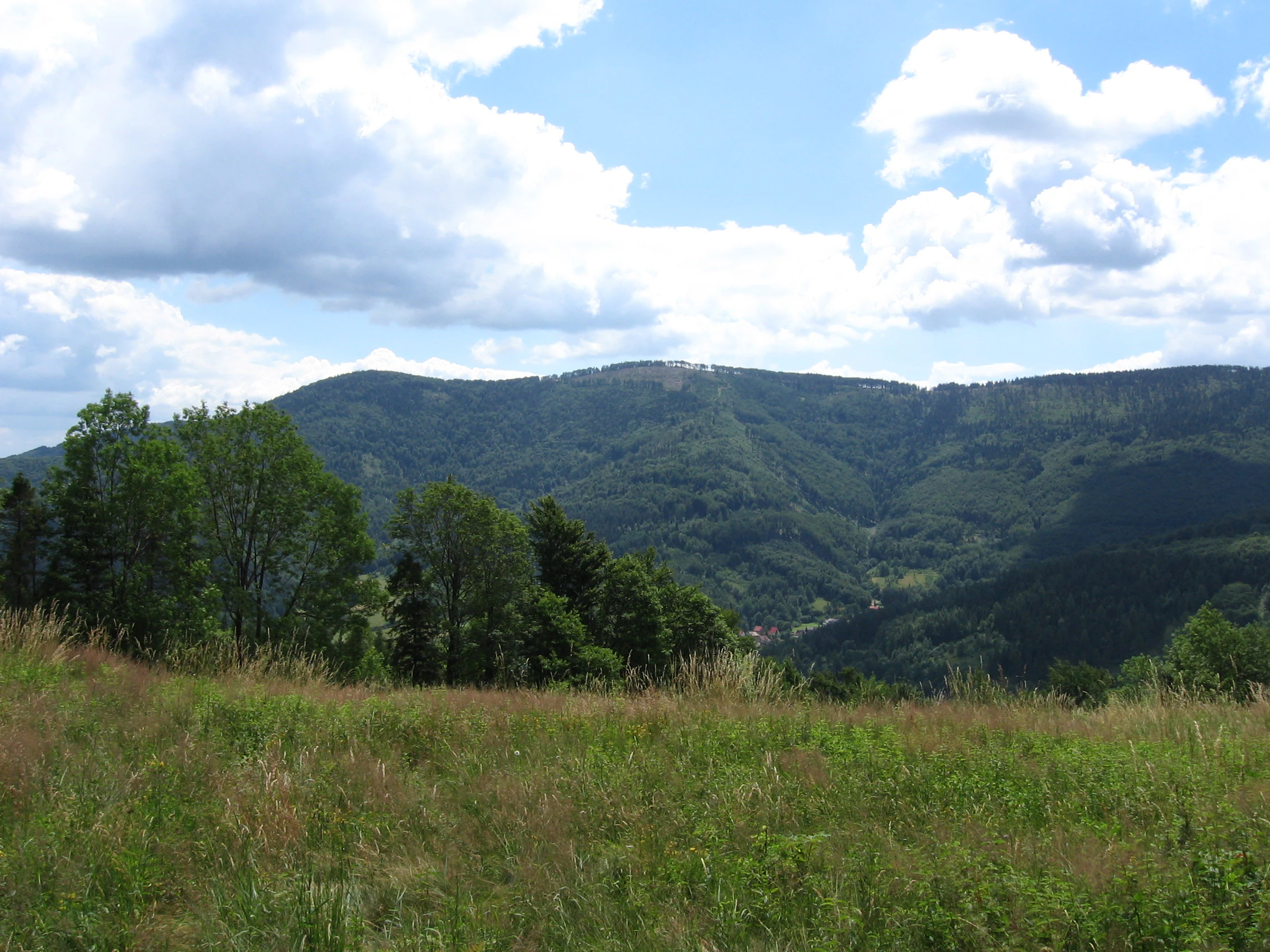
A view of Czupel Mountain, the highest peak in the Little Beskids range, viewed from Miedzybrodzie Bialskie.

Little Beskids Landscape Park history and protected-area timeline

The park was created relatively recently in the modern history of Polish nature conservation, established on 16 June 1998 through Regulation No. 9/98 of the Voivode of Bielsko. Its creation came during a period when Poland was significantly expanding its network of landscape parks in the 1990s, particularly in the Carpathians, as part of efforts to safeguard mountain landscapes that combined ecological value with strong cultural and recreational significance.

The Little Beskids had long been appreciated locally for their scenery and forest resources, but the formal landscape park designation brought them under unified protection and management. The park's structure, including its central protected area and a surrounding buffer zone (otolina), reflects the standard Polish landscape park model of that era, in which a regulated core area is shielded from outside pressures by a transition zone.

Since its establishment, the park has been managed jointly by landscape park teams in both voivodeships: the Zespół Parków Krajobrazowych Województwa Śląskiego, based in the Silesian side, and the Zespół Parków Krajobrazowych Województwa Małopolskiego, based in the Lesser Poland portion. The park's location within the Natura 2000 site Beskid Mały further embeds it in European-level conservation frameworks aimed at preserving Carpathian habitats and species.

Little Beskids Landscape Park landscape and geographic character

The landscape of Little Beskids Landscape Park is defined by two clearly separated mountain groups arranged around the valley of the Soła. On the western side runs the long, forested ridge of Magurka Wilkowicka, whose highest point, Czupel, rises to 933 meters above sea level and offers commanding views over the surrounding lowlands and the Międzybrodzie reservoirs. On the eastern side spreads the Andrychów Beskids, a more broken massif whose summit, Łamana Skała, reaches 929 meters and which descends in long wooded ridges toward the Wadowice foothills.

Between these two groups the Soła valley forms a wide, east-west oriented lowland corridor, occupied by reservoirs, villages, roads, and transport routes. This valley not only separates the park's two mountain blocks but also gives the entire park its distinctive geometric character, almost like two raised hands with an open palm in between.

Geologically, the elevations are built primarily from thick layers of Godula sandstone, which produces relatively resistant uplands and is locally responsible for the rocky outcrops and shallow caves of the area. Toward the south of the park, the bedrock shifts to include limestones and shales, introducing small-scale variations in soil chemistry, slope shape, and vegetation. The sandstone regions are also known for their cave systems, which form one of the park's most characteristic subterranean features.

Even outside the two named summits, the landscape remains scenically rich: forested ridges, sweeping beech stands, hidden valleys, and small clearings create the visual rhythm typical of the western Carpathians. Despite the modest elevations, the relief feels strong because the surrounding lowlands fall to roughly 300 to 400 meters, so the park rises noticeably above its neighboring basins and plains.

Little Beskids Landscape Park ecosystems, habitats, and plant life

Ecologically, the park belongs to the Carpathian forest zone of central Europe, dominated by mixed deciduous-coniferous woodlands. The most characteristic communities include beech forests, fir-beech forests, and patches of spruce, along with smaller areas of upland grassland and rocky habitat. The position of the Little Beskids between the Silesian and Makowski Beskids gives the park a transitional ecological character, with species and communities from both neighboring ranges represented.

Within the broader forested matrix, the park protects several particularly sensitive ecosystem types. Cliff and rock communities associated with sandstone outcrops and karst zones host specialized flora, while the cave systems support distinct bat populations and cave-adapted invertebrate communities. Stream valleys along the Soła and its tributaries create riparian habitats important for amphibians, aquatic invertebrates, and certain fish species.

Human influence remains visible throughout the park in the form of meadows, pastures, forest roads, and former agricultural terraces, particularly on the lower slopes. This mosaic of natural and semi-natural habitats is part of what the landscape park designation is intended to preserve, recognizing that the Carpathian identity of this region is shaped by centuries of interaction between people, forests, and mountain terrain.

Little Beskids Landscape Park wildlife and species highlights

The wildlife of the Little Beskids is typical of the western Carpathians, with forest mammals such as red deer, roe deer, wild boar, and foxes forming the most conspicuous large fauna. Smaller mammals including martens, weasels, and various bats are also present, with caves in the sandstone bedrock providing particularly important roosting sites for bat colonies.

The birdlife reflects the forest mosaic character of the park. Mixed beech and conifer stands support typical woodland species, including woodpeckers, nuthatches, forest-dwelling thrushes, and various small passerines. Raptors such as buzzards and, in suitable areas, larger birds of prey patrol the ridgelines, while stream valleys attract dippers and other water-associated species. The combination of forest interior, cliff habitats, and river valleys supports a relatively diverse bird community for a park of this size.

Amphibians and reptiles are associated mainly with the wetter valley bottoms, small streams, and reservoir edges, while fish populations inhabit the Soła and its tributaries. Although the park does not host the highest-profile large mammals of Poland's eastern wildernesses, its biodiversity value lies in the integrity of its forest habitats and the connectivity it maintains between larger Carpathian ecosystems further west and east.

Little Beskids Landscape Park conservation status and protection priorities

As a designated landscape park, the Little Beskids is protected primarily for the preservation of its scenic mountain landscape and the natural, cultural, and recreational values associated with it. The legal basis, established in 1998, places the park under a regulatory regime that aims to balance ecological protection with the continuation of traditional land uses such as forestry, agriculture, and low-intensity tourism.

Within the park, three nature reserves give additional, stricter protection to specific sites of high natural value: Szeroka w Beskidzie Małym, Zasolnica, and Madohora. These reserves typically safeguard intact forest communities, rock and cliff habitats, or particularly valuable plant populations, and they represent the highest tier of conservation within the park's boundaries. Around the central area, a buffer zone of about 227 square kilometers moderates the impact of surrounding settlements, infrastructure, and agriculture.

The park is also integrated into the broader European conservation framework through its overlap with the Natura 2000 site Beskid Mały, which highlights specific habitat types and species of community interest. Together, the national landscape park status, the internal reserves, and the Natura 2000 designation make the park an important node in the conservation network of the western Carpathians, particularly in a region where settlement pressure is high.

Little Beskids Landscape Park cultural meaning and human context

The park's landscape carries deep cultural significance, as the Little Beskids have long supported small-scale mountain agriculture, forestry, and local craft traditions. Villages on both the Silesian and Lesser Poland sides, including places such as Porąbka, Ślemień, and Stryszawa, are embedded in the park's buffer zone and contribute to its identity as a living cultural landscape rather than a strictly untouched wilderness.

The region has historical associations with Polish mountain culture more broadly, including the legacy of highland settlements and the seasonal rhythms of pastoral and forest life that shaped the Carpathian foothills for generations. Religious and folk traditions are reflected in the presence of small wooden churches, roadside shrines, and seasonal customs that remain part of village life around the park's perimeter.

In modern times, the park supports a culture of low-intensity recreation, hiking, and nature education. Its proximity to urban centers such as Bielsko-Biała, Andrychów, and Wadowice means that it functions both as a natural retreat for nearby residents and as a place where younger generations continue to encounter traditional Carpathian landscapes and the cultural memory associated with them.

Top sights and standout views in Little Beskids Landscape Park

The strongest highlights of Little Beskids Landscape Park include its twin-ridged mountain silhouette, with Czupel at 933 meters on the Magurka Wilkowicka ridge and Łamana Skała at 929 meters in the Andrychów Beskids. The wide Soła valley between these two massifs gives the park a distinctive and easily recognized shape on any map of southern Poland.

Equally notable are its sandstone bedrocks and cave systems, which add a small but fascinating karst dimension to what is otherwise a forested Carpathian landscape. The presence of three dedicated nature reserves, the overlap with the Natura 2000 site Beskid Mały, and the extensive network of hiking trails through beech and fir forests round out a park that, despite its modest size, offers a dense and varied experience of the western Carpathians.

For visitors from Bielsko-Biała, Żywiec, and the Wadowice region, the park functions as the closest substantial green landscape and as a place where mountain scenery, forest biodiversity, and traditional highland culture all come together in a single, easily accessible setting.

Best time to visit Little Beskids Landscape Park

The park's character changes meaningfully with the seasons. Late spring and early summer are particularly rewarding for hikers, as the beech and mixed Carpathian forests come into full leaf, wildflower meadows bloom in the lower foothills, and the mountain ridges offer wide views under generally stable weather conditions. This period also tends to be the most comfortable for longer walks along the park's ridgelines and valley trails.

Autumn brings strong visual appeal as the deciduous forests turn color, with the mixed beech-fir stands producing some of the most striking seasonal contrasts in the Little Beskids. Cooler temperatures and clearer skies often make this a favorite time for photographers and those interested in the quieter atmosphere of the Carpathian foothills.

Winter transforms the park into a calm, snow-covered landscape, especially at higher elevations such as Czupel and the ridges of Magurka Wilkowicka. Snow cover typically arrives from late December into February or March, depending on the year, and gives the park a quiet, secluded feel. Visitors should be aware that mountain weather in this region can change rapidly and that higher trails may be more demanding under winter conditions.


Monthly climate preview

Long-term representative averages tracking annual temperature and precipitation cycles

Park Krajobrazowy Beskidu Malego Climate and Monthly Temperature Normals

Historical data records sustained temperature shifts alongside measured precipitation totals across the representative coordinate of Park Krajobrazowy Beskidu Malego. Examining the complete monthly climate normals reveals detailed cyclical variations that define the local environmental baseline.
Annual mean8 °C
-4 °C19 °C
Jan-4°
Feb-2°
Mar
Apr
May13°
Jun17°
Jul19°
Aug19°
Sep14°
Oct
Nov
Dec-2°
Warmest month
July

19.2 °C

Coolest month
January

-3.5 °C

Wettest month
July

3.5 mm/day

Driest month
December

1.5 mm/day

Park location guide

Geography guide, regional context, and park location map for Little Beskids Landscape Park

Little Beskids Landscape Park park geography, regions, and map view in Poland

Understand where Little Beskids Landscape Park sits in Poland through a broader geographic reading of the surrounding landscape, nearby location context, and its mapped position within the national park landscape.

How Little Beskids Landscape Park fits into Poland

Poland, officially the Republic of Poland, is a Central European country spanning from the Baltic Sea in the north to the Carpathian Mountains in the south. It borders Germany, Czech Republic, Slovakia, Ukraine, Belarus, Lithuania, and Kaliningrad Oblast. The country has a temperate climate, diverse landscapes, and is known for its rich history, cultural heritage, and strong economic position within the EU.

Wider geography shaping Little Beskids Landscape Park in Poland

Poland occupies 312,696 km2 in Central Europe, extending from the Baltic Sea coast in the north to the Sudetes and Carpathian Mountains in the south. It borders Germany to the west, Czech Republic and Slovakia to the south, Ukraine and Belarus to the east, and Lithuania and Kaliningrad Oblast to the northeast. The landscape includes lowland plains, uplands, and mountain ranges.

Map view of Little Beskids Landscape Park

Use this park location map to pinpoint Little Beskids Landscape Park in Poland, understand its exact geographic position, and read its mapped placement within the surrounding landscape more clearly.

Pigeon | © OpenStreetMap contributors

Location context for Little Beskids Landscape Park

Lesser Poland VoivodeshipSilesian Voivodeship
Recorded earthquake history

Review Historical Seismic Records for Park Krajobrazowy Beskidu Małego

Explore the comprehensive catalogue of documented earthquakes located near Park Krajobrazowy Beskidu Małego. This MoriAtlas resource provides structured access to historical seismic data, allowing for deeper investigation into the geophysical context of this protected landscape.

Park Krajobrazowy Beskidu Małego Earthquake History

Catalogued events

62 events

Strongest magnitude

Magnitude 4.2

Most recent event

Oct 4, 2023

This history includes earthquakes recorded inside the park or within 50 km of its borders

Visualizing the forested ridges, sandstone uplands, and valleys of the Little Beskids

Park Krajobrazowy Beskidu Małego Photos and Landscape Scenery

Protected area imagery reveals the twin mountain massifs, mixed beech forests, and valley reservoirs defining Park Krajobrazowy Beskidu Małego. Visual research offers a clear perspective on the rugged Carpathian terrain, sandstone rock formations, and natural habitats spanning the region.

A wide landscape view of a forested mountain peak under a blue sky with white clouds, with a grassy meadow in the foreground.

Park atlas

Compare adjacent Western Carpathian reserves and regional mountain geography

Parks Near Park Krajobrazowy Beskidu Małego and Surrounding Protected Landscapes

Browsing other protected areas near Park Krajobrazowy Beskidu Małego reveals the broader network of forested Carpathian ridges and river valley reserves across southern Poland. Expanding the geographic comparison connects individual mountain massifs with neighboring regional parks and protected landscapes.
A horizontal watercolor painting depicting soft, layered green hills and purple-toned mountain ridges in the distance, with a foreground of stylized evergreen trees.
Protected landscapeSilesian Voivodeship
17 km away#1 closest

West

Park Krajobrazowy Beskidu Śląskiego: Geographic Atlas of Protected Silesian Beskid Landscapes

Mapped mountain ridges, river headwaters, and protected forest reserves.

Gain insight into the ecological and structural character of Park Krajobrazowy Beskidu Śląskiego. This resource documents the park's flysch geological formations, rare cave systems, and the hydrological significance of the Vistula River headwaters within the Silesian Beskids.

Area
386.2 km²
Established
1998
Relief
Mountain
Climate
Alpine
A watercolor painting showing a rolling landscape with distant mountains, soft green and pink trees, and gentle hills on a plain white background.
Protected landscapeBielsko-Biała
About 18 km away#2 closest

West

Cygański Las Protected Landscape: Mapped Geography and Foothill Forest in Bielsko-Biała

An expansive 593-hectare woodland corridor in the Silesian Beskids.

Cygański Las functions as a formal protected landscape complex, preserving diverse forest communities from fertile beech stands to mountain sycamore on the slopes of Bielsko-Biała. This terrain serves as the essential southern trailhead for the Silesian Beskids, connecting the urban fabric of the city with the rugged elevations of Szyndzielnia, Klimczok, and Magurka Wilkowicka through a network of historic trails.

Area
5.93 km²
Established
1997
Relief
Mountain
Climate
Temperate
Protected landscapeSilesian Voivodeship
19 km away#3 closest

South

Żywiecki Park Krajobrazowy: Geographic Atlas and Protected Landscape Overview

A detailed look at Beskid mountain terrain and Silesian regional geography.

Żywiecki Park Krajobrazowy encompasses a diverse mountain environment within the Silesian Voivodeship, where parallel ridges and deeply incised valleys create a complex dendritic structure. This protected landscape is marked by its transition from dense beech and spruce forests to high-mountain zones, featuring unique karst formations and significant waterfall systems along its river networks.

Area
358.7 km²
Established
1986
Relief
Mountain
Climate
Temperate
A horizontal watercolor painting depicting a soft green landscape with rolling hills, distant light purple mountain ridges, and a central water feature, rendered in a light, atmospheric style.
Protected landscapeSilesian Voivodeship
About 23 km away#4 closest

West

Dolina Wapienicy: Protected Landscape and Carpathian Mountain Valley in Silesian Voivodeship

Mapped terrain, forest ecosystems, and ridge geography

Dolina Wapienicy acts as a protected landscape complex within the urban-adjacent geography of the northern Silesian Beskids. The area encompasses mature Carpathian beech forests and rare upper montane spruce stands, organized around the Wapienica River and the Mościcki Dam reservoir. It remains a focal point for understanding how mountain valley systems maintain biodiversity and near-natural wilderness characteristics in close proximity to major urban settlements.

Area
15.19 km²
Established
1993
Relief
Mountain
Climate
Temperate
Watercolor painting of rolling green hills and distant forested mountains under a light sky
National parkLesser Poland Voivodeship
29 km away#5 closest

Southeast

Babia Góra National Park: Carpathian National Park with Mapped Terrain and Unique Flora

Explore protected landscapes and regional geography in Lesser Poland Voivodeship.

Babia Góra National Park, a significant protected area in Poland's Carpathian Mountains, offers a distinct atlas exploration experience. Its landscape is defined by the prominent Babia Góra massif, featuring complete altitudinal vegetation zones, rare endemic plant species, and notable terrain characteristics. As a UNESCO biosphere reserve, it provides valuable insights into Carpathian ecosystems and regional geographic context, making it a key destination for structured discovery of protected lands and natural landscapes.

Area
33.92 km²
Established
1954
IUCN
II
Visitors
81K annual
Watercolor painting of a green, rolling mountain range and hills set against a white background.
National parkLesser Poland Voivodeship
29 km away#6 closest

Southeast

Babiogórski Park Narodowy: Geographic Overview and Protected Carpathian Mountain Terrain

Mapping alpine vegetation zones in the Lesser Poland Voivodeship

Babiogórski Park Narodowy encompasses the massif of Babia Góra, offering a complex mountain landscape that transitions from beech-fir forests to true alpine summit zones. Recognized for its clear vertical vegetation layering, this protected area holds significant ecological importance within the Western Carpathians and serves as a major landmark for studying high-altitude terrain in southern Poland.

Area
33.92 km²
Established
1954
Visitors
81K annual
Relief
Mountain
Nature reserveSilesian Voivodeship
About 30 km away#7 closest

West

Morzyk Nature Reserve: A Protected Forest Landscape in the Silesian Foothills of Southern Poland

Mapping forest communities and ravine terrain within the Silesian Voivodeship.

Morzyk Nature Reserve protects a rich mosaic of deciduous woodlands and beech-dominated stands in southern Poland. This compact forest reserve offers deep insight into the ecological character of the Silesian Foothills, featuring well-preserved ravines and old-growth trees that anchor the regional geography.

Area
0.103 km²
Established
1996
Relief
Upland
Climate
Temperate
Nature reservePoland
32 km away#8 closest

West

Kościół w Górkach Wielkich: Nature Reserve and Protected Habitat in Silesian Voivodeship

Mapping cultural heritage and ecological sanctuary boundaries

Explore the geography of Kościół w Górkach Wielkich, a specialized Natura 2000 protected site situated within the Brenna commune. This entry provides context on the church architecture and the local protected terrain that creates a essential roost for regional bat populations in the Silesian Beskids foothills.

Relief
Lowland
Scope
Terrestrial
Water
Minor water

Common questions about visiting, size, designation, and location context for Little Beskids Landscape Park

Little Beskids Landscape Park FAQs for park facts, access, geography, and protected area context

Find quick answers about Little Beskids Landscape Park, including protected-area facts, park geography, trail and visitor context, and how the park fits into its surrounding country and regional landscape.
MoriAtlas Explorer

Continue Your Protected Areas Search Across the Global Atlas

Deepen your exploration by continuing the structured search for national parks and protected areas worldwide. Utilize the comprehensive filtering capabilities to compare different conservation landscapes and refine your understanding of global park geography. Discover more about the distribution and characteristics of protected natural areas.

Global natural geography