
Mori Atlas logo
State or regional parkLittle Qualicum Falls Provincial Park

Mapping the river canyons, mountain lake shores, and old-growth forest terrain of Vancouver Island.

Little Qualicum Falls Provincial Park: A Comprehensive Geographic and Protected Landscape Atlas

Little Qualicum Falls Provincial Park encompasses a distinct protected landscape on central Vancouver Island, serving as a critical corridor between the alpine-fed Cameron Lake and the rushing Little Qualicum River. The park features a complex topography of cascading bedrock waterfalls, narrow river canyons, and mature coastal forest stands. This atlas entry provides a structured perspective on the park boundaries, regional ecological features, and the varied terrain that defines this unique section of British Columbia.

Vancouver IslandBritish ColumbiaProvincial ParkOld-Growth ForestDouglas FirWaterfalls
A vibrant graphic illustration showing a tiered waterfall flowing through a rocky canyon surrounded by coniferous trees and mountains.

Little Qualicum Falls Provincial Park

State or regional park

Park overview

Structured park overview, official facts, and landscape profile for Little Qualicum Falls Provincial Park

Little Qualicum Falls Provincial Park park facts, protected area profile, and essential visitor context

Review the core facts for Little Qualicum Falls Provincial Park, including designation, size, terrain, visitor scale, habitats, and operating context in one park-focused overview.

About Little Qualicum Falls Provincial Park

Little Qualicum Falls Provincial Park is a mid-sized provincial park on central Vancouver Island, sitting just inland from the Strait of Georgia coastline between Parksville and Qualicum Beach. The park straddles a transitional zone where the flat agricultural and residential land of the east coast rises into the mountains of the Island's interior, anchored by Mount Arrowsmith to the south and Mount Wesley to the north.

At the heart of the park is Cameron Lake, a freshwater body that occupies a glacially scoured basin along the upper Little Qualicum River. The park wraps around the entire southern shore of Cameron Lake, giving it miles of lakeshore within its boundaries. From Cameron Lake, the Little Qualicum River begins its descent toward the ocean, cutting through bedrock to create the series of cascades and waterfalls for which the park is named. The most striking drop in this section of river is Keyhole Falls, a tall, narrow cascade that issues through a rock opening and crashes into a deep pool below.

The forest environment is a defining part of the park's character as well. When Little Qualicum Falls was first protected in 1940, the explicit goal was to safeguard an old-growth Douglas Fir stand, and those large, old trees continue to anchor the park's ecological identity. The combination of lake, river, falls, canyon, and coastal conifer forest makes the park feel more varied than its modest footprint would suggest, and it functions as a compact showcase of central Vancouver Island's natural landscape.

The park's location, near Parksville and within easy reach of Qualicum Beach and Port Alberni, also ties it into the broader network of outdoor destinations on the east-central coast of Vancouver Island. The Island Rail Corridor line running toward Port Alberni passes through the park, a reminder of how tightly the park's geography is woven into the transportation corridors of the island.

Quick facts and research context for Little Qualicum Falls Provincial Park

Little Qualicum Falls Provincial Park covers roughly 440 hectares and sits on central Vancouver Island near Parksville, British Columbia. It is administered by BC Parks and has been a designated protected area since 1940.

The park protects the southern shore of Cameron Lake, a glacial lake at the foot of Mount Arrowsmith, as well as a stretch of the Little Qualicum River where the water cuts through bedrock to form cascades and falls. Its old-growth Douglas Fir forest was a key reason the area was originally set aside as a park.

The Island Rail Corridor, the rail line running from Victoria toward Port Alberni, passes through the park, linking it historically to the transportation geography of central Vancouver Island.

Protection and recognition

Examine documented terrestrial conservation frameworks and administrative scope.

Little Qualicum Falls Provincial Park Protection Status and Recognition

Little Qualicum Falls Provincial Park maintains a defined terrestrial protection status within its regional conservation framework. Official records outline management scope and administrative parameters without external international designations.

Protection details

Protection scope
Terrestrial
Transboundary protection
No
Park context

Deeper park guide and search-rich context for Little Qualicum Falls Provincial Park

Little Qualicum Falls Provincial Park history, landscape, wildlife, and travel context

Explore Little Qualicum Falls Provincial Park through its history, landscape character, ecosystems, wildlife, conservation priorities, cultural context, and seasonal travel timing in a structured park guide built for atlas discovery and search intent.

Why Little Qualicum Falls Provincial Park stands out

Little Qualicum Falls Provincial Park is especially known for its waterfalls along the Little Qualicum River and for the mature old-growth Douglas Fir forest that originally justified its protection. The river drops through a rocky canyon inside the park, producing a sequence of cascades, with the upper Keyhole Falls marking one of the most prominent drops. Equally characteristic is the park's lakeside setting on Cameron Lake, framed by Mount Arrowsmith to the south and Mount Wesley to the north. The combination of mountain-fed lake, plunging river, and coastal old-growth forest gives the park a layered identity that mixes freshwater scenery, riparian habitat, and classic west coast forest character in a relatively small area.
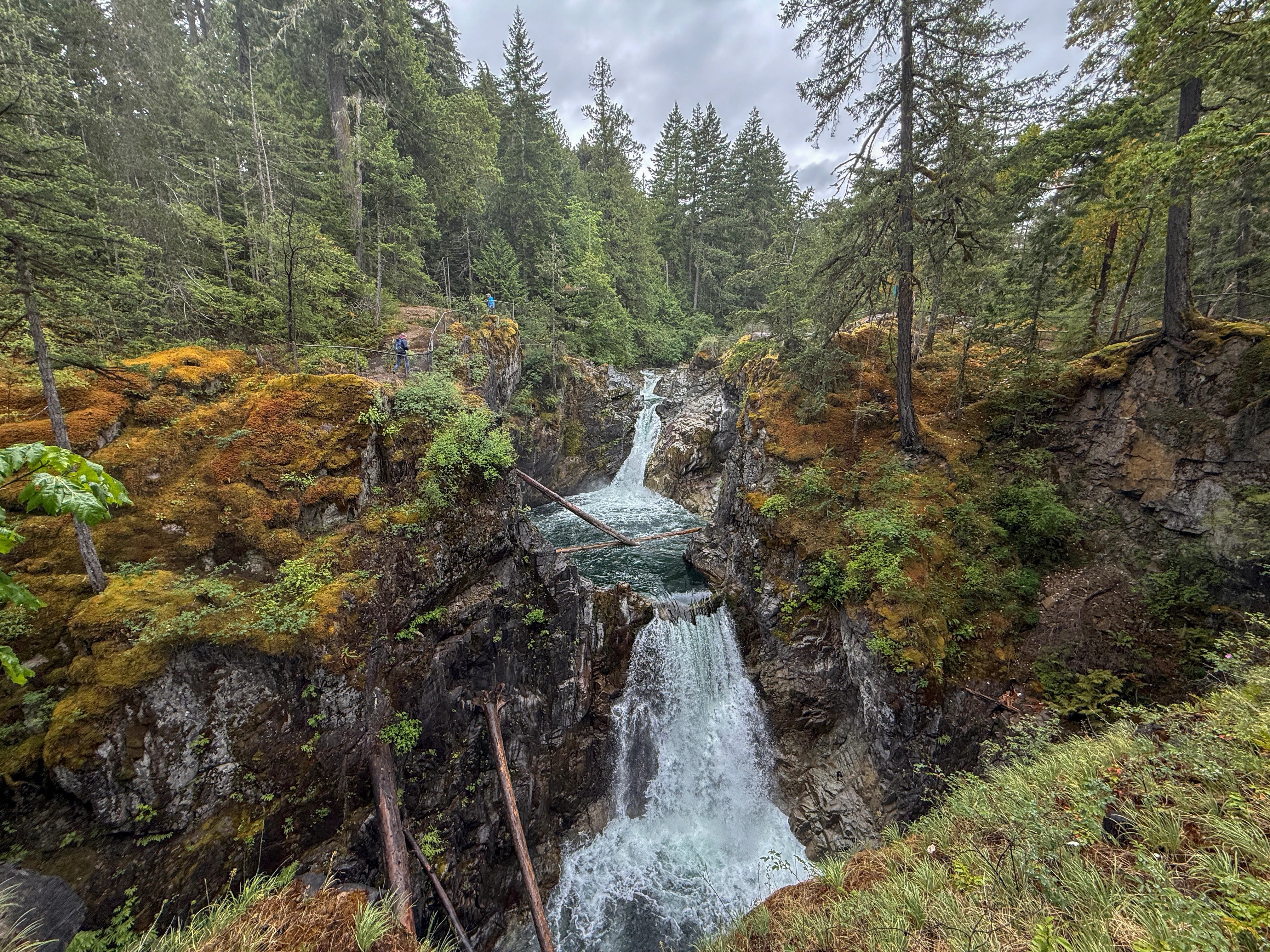
A multi-tiered waterfall cascading through a rocky canyon, surrounded by mossy rocks and dense coniferous forest under an overcast sky.
The tiered waterfalls of Little Qualicum Falls Provincial Park, surrounded by lush temperate rainforest.

Little Qualicum Falls Provincial Park history and protected-area timeline

Little Qualicum Falls Provincial Park was established in 1940, making it one of the older provincial parks in the central Vancouver Island region. Its original purpose, as recorded in its early history, was to protect the old-growth Douglas Fir forest that lines the Little Qualicum River and the southern shore of Cameron Lake.

At a time when logging was rapidly converting Vancouver Island's accessible lowland forests, setting aside this stand helped preserve a representative example of the island's original coastal temperate rainforest character. The park's creation reflects the broader mid-twentieth century movement in British Columbia to formally reserve representative natural landscapes through the provincial parks system.

Since its establishment, the park has remained under the administration of BC Parks, the provincial agency responsible for managing British Columbia's system of provincial parks. Over time it has been developed for public recreation, with trails, campgrounds, and day-use areas added, but its foundational purpose of protecting the old-growth forest and the scenic river landscape has remained central to its identity.

Little Qualicum Falls Provincial Park landscape and geographic character

The landscape of Little Qualicum Falls Provincial Park is defined by a narrow, layered geography that packs multiple distinct settings into a relatively compact area. On one side of the park lies Cameron Lake, a calm freshwater lake sitting in a basin surrounded by forested ridges and the slopes of Mount Arrowsmith. The lake's shoreline is irregular, and the park captures the entire southern edge of this basin.

From Cameron Lake, the terrain drops into the canyon of the Little Qualicum River. The river here is a mountain-fed stream that flows swiftly over bedrock, producing a step-like series of cascades and the named Little Qualicum Falls. Further upstream, the river passes through Keyhole Falls, where the water narrows through an opening in the rock before plunging into a deep pool. The canyon walls and exposed bedrock along the river give this section of the park a rugged, dramatic quality that contrasts with the smoother shoreline of Cameron Lake.

Surrounding both the lake and the river is a classic Vancouver Island coastal forest, dominated by tall conifers rising from mossy understory. The terrain rolls and steepens as the land climbs toward Mount Arrowsmith and Mount Wesley. In certain sections, the topography between these two peaks creates a wind funnel effect, channeling air over Cameron Lake.

Together, lake, river canyon, falls, and forested ridges compose the visual and physical backbone of the park.

Little Qualicum Falls Provincial Park ecosystems, habitats, and plant life

Ecologically, Little Qualicum Falls Provincial Park sits within the Coastal Western Hemlock biogeoclimatic zone, one of the most productive temperate forest environments in British Columbia. The park's original designation in 1940 was driven specifically by the presence of old-growth Douglas Fir, a dominant species of these lowland and montane forests. Today, these older trees still stand as one of the most distinctive ecological features of the park.

The park harbors several overlapping habitats within a compact footprint. The shoreline and shallow waters of Cameron Lake support aquatic and wetland-edge vegetation, while the river corridor of the Little Qualicum River adds a riparian band of moisture-loving plants, mosses, and shrubs. Away from the water, the forest floor is shaded by tall conifers and enriched with fallen logs and moss, providing habitat for a wide range of forest-dwelling creatures.

The vertical layering of the park, from the lake to the river canyon and up to the forested mountain flanks, gives it an unusually varied microhabitat structure. This concentration of freshwater, riparian, and old-growth forest environments in one relatively small park contributes significantly to its ecological character on central Vancouver Island.

Little Qualicum Falls Provincial Park wildlife and species highlights

The old-growth forest, the river, and the lake together create favorable conditions for a varied animal community. The Little Qualicum River is a well-known salmon-bearing stream, and its runs upstream to spawning grounds in the park's reach are one of the most recognized wildlife phenomena associated with the area. In autumn, returning salmon attract predators and scavengers along the riverbanks, while the open pools below the falls draw fish-hunting birds.

The mature Douglas Fir forest provides nesting cavities and perching habitat for a range of forest birds, including typical Vancouver Island species such as woodpeckers, jays, owls, and seasonal migrants. Raptors are also regularly associated with this kind of mosaic of lake, forest, and open ridge.

Cameron Lake adds an aquatic dimension to the wildlife picture. Waterfowl, shoreline small mammals, and lake-associated birds use the lake and its edges, while amphibians and invertebrates occupy the wet margins around both the lake and the river. The combination of old-growth trees, salmon-bearing water, and lake habitat gives the park a wildlife profile typical of the rich ecosystems found elsewhere on central Vancouver Island.

Little Qualicum Falls Provincial Park conservation status and protection priorities

From a conservation standpoint, Little Qualicum Falls Provincial Park is significant primarily for the old-growth Douglas Fir forest that prompted its establishment in 1940. Old growth of this kind, once widespread on Vancouver Island, has been substantially reduced by logging, and protected stands like the one preserved here are increasingly important as refuges for old-growth-dependent species and as genetic reservoirs for the original forest type.

The park also serves a conservation function through its protection of the Little Qualicum River corridor and Cameron Lake's southern shoreline. By safeguarding both the aquatic ecosystem and its surrounding riparian forest, the park preserves a connected freshwater to forest transition zone that supports salmon, aquatic invertebrates, and the wider food web.

As a long-established provincial park under BC Parks, it contributes to the broader network of protected natural areas on Vancouver Island. Although modest in area compared to some of the island's larger parks, its combination of old-growth forest, intact river canyon, and lake shoreline gives it an outsized conservation value relative to its size.

Little Qualicum Falls Provincial Park cultural meaning and human context

Little Qualicum Falls Provincial Park sits on the traditional territory of Indigenous peoples of the east coast of Vancouver Island, including nations associated with the broader Qualicum and Nanaimo region. The Qualicum name itself, used for the river, the falls, the nearby town of Qualicum Beach, and the park, is drawn from Indigenous place names for the area.

In more recent cultural terms, the park has become embedded in the outdoor recreation identity of central Vancouver Island. It is closely associated with Parksville, Qualicum Beach, and the broader east-central island community, and has long been part of the regional experience of accessible west coast wilderness. The presence of the Island Rail Corridor line through the park also reflects the historical importance of rail transport to logging, settlement, and tourism on this part of the island.

Top sights and standout views in Little Qualicum Falls Provincial Park

Little Qualicum Falls Provincial Park is anchored by several standout natural features that collectively define its appeal: the entire southern shore of Cameron Lake, a glacially formed mountain lake framed by Mount Arrowsmith; a dramatic stretch of the Little Qualicum River including cascades, named Little Qualicum Falls, and the prominent Keyhole Falls upstream; and a protected old-growth Douglas Fir forest that has been the park's core value since 1940.

A network of roughly six kilometers of walking trails links the lake, the river, and the falls, allowing visitors to experience these different environments in a single day. The compact scale of the park means that waterfalls, lake shore, and old-growth forest can all be encountered without long travel between them, making the park a particularly efficient showcase of central Vancouver Island's natural character.

Best time to visit Little Qualicum Falls Provincial Park

The character of Little Qualicum Falls Provincial Park shifts meaningfully with the seasons. Spring brings high water and strongly flowing falls on the Little Qualicum River, with fresh green growth in the forest and active wildlife movement along the river corridor. Summer is the busiest period, with warmer weather suitable for swimming in Cameron Lake, camping in park campgrounds, and easier walking on trails; the wind funnel between Mount Wesley and Mount Arrowsmith also creates favorable conditions for sailboarding on the lake.

Autumn is arguably the most distinctive natural season in the park, when salmon runs return to the Little Qualicum River to spawn. These runs draw wildlife concentrations to the river, including predators and birds, and the surrounding forest takes on the rich colors of the coastal temperate rainforest in fall. Winter is the quietest period, with cooler, wetter weather, strong river flow, and a moody, atmospheric forest landscape that emphasizes the old-growth character of the park.

Monthly climate preview

Long term temperature and precipitation averages measured across twelve monthly intervals

Little Qualicum Falls Provincial Park Climate Normals and Monthly Weather Patterns

Little Qualicum Falls Provincial Park exhibits measured variations in monthly average temperature and precipitation across a representative coordinate point. Reviewing the complete climatology profile provides deeper insight into long term environmental rhythms and baseline conditions.
Annual mean10 °C
4 °C18 °C
Jan
Feb
Mar
Apr
May13°
Jun15°
Jul18°
Aug18°
Sep15°
Oct10°
Nov
Dec
Warmest month
August

18.1 °C

Coolest month
December

4.2 °C

Wettest month
November

5.7 mm/day

Driest month
July

1 mm/day

Park location guide

Geography guide, regional context, and park location map for Little Qualicum Falls Provincial Park

Little Qualicum Falls Provincial Park park geography, regions, and map view in Canada

Understand where Little Qualicum Falls Provincial Park sits in Canada through a broader geographic reading of the surrounding landscape, nearby location context, and its mapped position within the national park landscape.

How Little Qualicum Falls Provincial Park fits into Canada

Canada is a federal parliamentary constitutional monarchy spanning North America from the Atlantic to the Pacific and Arctic Oceans. With a population of over 41 million, it is officially bilingual in English and French at the federal level. The country gained independence from the United Kingdom through a gradual process culminating in 1982.

Wider geography shaping Little Qualicum Falls Provincial Park in Canada

Canada occupies the northern portion of North America, sharing its longest international border with the United States. The country extends from the Atlantic Ocean to the Pacific Ocean and northward into the Arctic Ocean, giving it the longest coastline of any nation.

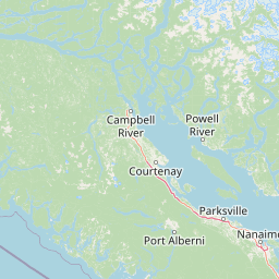
Map view of Little Qualicum Falls Provincial Park

Use this park location map to pinpoint Little Qualicum Falls Provincial Park in Canada, understand its exact geographic position, and read its mapped placement within the surrounding landscape more clearly.

Pigeon | © OpenStreetMap contributors

Location context for Little Qualicum Falls Provincial Park

British Columbia
Recorded earthquake history

View Recorded Earthquake History Near Little Qualicum Falls Provincial Park

Investigate the history of recorded seismic events associated with the location of Little Qualicum Falls Provincial Park. MoriAtlas provides a clear, data-driven catalogue of regional earthquakes to support your geographic understanding of this British Columbia protected landscape.

Little Qualicum Falls Provincial Park Earthquake History

Catalogued events

5 events

Strongest magnitude

Magnitude 4.3

Most recent event

Dec 11, 2014

This history includes earthquakes recorded inside the park or within 50 km of its borders

Visualizing the rugged river canyons, old-growth forests, and mountain lakes of Vancouver Island

Little Qualicum Falls Provincial Park Photos, Scenery, and Protected Landscape Views

Explore curated photography documenting the dramatic river canyons, plunging waterfalls, and mature coastal forests defining Little Qualicum Falls Provincial Park. Visual research helps observers interpret the complex terrain, riparian habitats, and protected environmental character of Vancouver Island.

A multi-tiered waterfall cascading through a rocky canyon, surrounded by mossy rocks and dense coniferous forest under an overcast sky.

Park atlas

Compare regional geography, nearby river canyons, and adjacent forest reserves across Vancouver Island

Explore Parks Near Little Qualicum Falls Provincial Park and Surrounding Protected Landscapes

Browsing other protected areas near Little Qualicum Falls Provincial Park reveals connected forest ecosystems and mountain-fed river basins across central Vancouver Island. Expanding the geographic comparison helps trace regional terrain patterns and understand broader conservation landscapes.
A horizontal watercolor illustration featuring a wooden boardwalk winding through a calm, light-filled landscape with soft green trees, grassy foreground, and rolling hills in the distance.
State or regional parkBritish Columbia
About 0.3 km away#1 closest

West

MacMillan Provincial Park: Mapped Geography and Protected Forest Landscapes

Vancouver Island, British Columbia

Examine the mapped footprint of MacMillan Provincial Park, home to iconic old-growth Douglas fir trees and the Cameron River delta. This protected area serves as a biogeoclimatic transition zone, showcasing the rich, moisture-retentive coastal forest environment that defines this specific section of Vancouver Island.

Area
3.01 km²
Established
1947
IUCN
III
Visitors
543.7K annual
State or regional parkBritish Columbia
About 9.3 km away#2 closest

Northwest

Horne Lake Caves Provincial Park: Mapped Protected Landscapes and Cave Networks

Vancouver Island protected area and karst geography

Horne Lake Caves Provincial Park protects a distinct array of limestone cave systems, including Main, Riverbend, and Euclataws caves. The area bridges underground geological formations with surface-level river recreation along the Qualicum River, providing a comprehensive look at the karst and forested terrain of central-eastern Vancouver Island.

Area
1.58 km²
Established
1971
IUCN
II
Relief
Upland
Watercolor painting of a waterfall surrounded by lush green trees and forest.
State or regional parkBritish Columbia
15 km away#3 closest

East

Englishman River Falls Provincial Park: Regional Geography and Protected Area Overview

Vancouver Island river canyon and coastal forest terrain

Englishman River Falls Provincial Park protects a concentrated area of canyon scenery and old-growth forest on the eastern side of Vancouver Island. The landscape is characterized by the dramatic steps of the Englishman River, deep plunge pools, and mature cedar and hemlock stands. This geography provides an essential look at the coastal rainforest ecosystems and river-fed topography that define the recreational corridors of British Columbia.

Area
0.97 km²
IUCN
II
Relief
Upland
Access
Easy access
A pale, minimalist watercolor painting depicting a wide, sandy beach shoreline with a line of evergreen trees in the distance.
State or regional parkBritish Columbia
19 km away#4 closest

East

Rathtrevor Beach Provincial Park: Coastal Geography and Protected Land Overview

Vancouver Island coastal terrain and forested landscapes

Spanning over 300 hectares, Rathtrevor Beach Provincial Park protects a rare combination of fine sandy beaches and ancient Douglas fir groves along the Strait of Georgia. This coastal sanctuary on Vancouver Island serves as a critical habitat for migrating birds and represents a preserved segment of regional geography amidst the surrounding developed shoreline.

Area
3.47 km²
Established
1967
IUCN
II
Visitors
836.2K annual
Watercolor painting of a tranquil body of water with gentle hills in the background and a cluster of trees on the right shore.
State or regional parkBritish Columbia
31 km away#5 closest

Northeast

Jedediah Island Marine Provincial Park: Coastal Terrain and Regional Protected Area Map

Mapping island boundaries and sheltered maritime ecosystems

Jedediah Island Marine Provincial Park offers a unique study in coastal geography, featuring a complex shoreline of pebble beaches and indented bays. Located within the Strait of Georgia, the park serves as a protected landmass that blends maritime forest ecosystems with open water corridors. Its boat-only access ensures the landscape remains a quiet, preserved example of Gulf Islands terrain.

Area
6.03 km²
Established
1995
IUCN
II
Relief
Lowland
A minimalist watercolor illustration showing rolling hills in the background and soft foliage in the foreground on a white background.
State or regional parkBritish Columbia
About 48 km away#6 closest

East

Petroglyph Provincial Park: Protected Indigenous Heritage and Coastal Geography

Cultural landscape and bedrock carvings in British Columbia

Petroglyph Provincial Park preserves a remarkable concentration of ancient carvings etched into the sandstone bedrock of the Nanaimo River estuary. This protected area on Vancouver Island provides a rare look at how Indigenous traditions integrated with powerful natural features, offering a unique geographic context for studying historical rock art in the Pacific Northwest.

Area
0.02 km²
Established
1948
IUCN
III
Relief
Lowland
A watercolor painting showing a horizontal landscape with a green forest in the foreground and soft pink, layered rolling hills in the background.
State or regional parkBritish Columbia
54 km away#7 closest

East

Morden Colliery Historic Provincial Park: Heritage Infrastructure and Regional Coal Mining History

Industrial landscape and historic rail corridor in British Columbia

Located near Nanaimo, this heritage site preserves the substantial concrete remains of the Morden Colliery. The park serves as a physical archive of southern Vancouver Island industrial life, contrasting engineering landmarks with local forest environments and interpretive trails along former coal railway alignments.

Area
0.04 km²
Established
1972
Relief
Lowland
Scope
Terrestrial
National parkBritish Columbia
54 km away#8 closest

South

Pacific Rim National Park Reserve: National Park Protected Landscape & Map Atlas

Mapped boundaries and regional geographic context in British Columbia.

Pacific Rim National Park Reserve stands as a distinct protected natural landscape, serving as a critical component of Canada's national park inventory. This page facilitates an atlas-style exploration of its mapped boundaries and its position within the broader geography of British Columbia. Understanding the park's protected status and its integration with the surrounding natural terrain offers valuable insight into conservation landscapes.

Area
511 km²
Established
1970
IUCN
VI
Visitors
1.2M annual

Common questions about visiting, size, designation, and location context for Little Qualicum Falls Provincial Park

Little Qualicum Falls Provincial Park FAQs for park facts, access, geography, and protected area context

Find quick answers about Little Qualicum Falls Provincial Park, including protected-area facts, park geography, trail and visitor context, and how the park fits into its surrounding country and regional landscape.
MoriAtlas Explorer

Continue Your Protected Areas Search Across the Global Atlas

Deepen your exploration by continuing the structured search for national parks and protected areas worldwide. Utilize the comprehensive filtering capabilities to compare different conservation landscapes and refine your understanding of global park geography. Discover more about the distribution and characteristics of protected natural areas.

Global natural geography