Mori Atlas logo
Wildlife reserveLizard Head Wilderness

Mapping the volcanic spires, high alpine ridges, and remote watershed geography of this wilderness

Lizard Head Wilderness: A Rugged Protected Landscape in the Colorado San Juan Mountains

Lizard Head Wilderness stands as a protected natural area within the San Juan Mountains of southwestern Colorado, encompassing high-elevation alpine terrain and volcanic geology. This wilderness expanse is defined by sharp ridges, glaciated basins, and the iconic namesake volcanic spire that anchors the regional skyline. Beyond the spire, the area provides a geographic focus for fourteeners including El Diente Peak, Mount Wilson, and Wilson Peak, while protecting the headwaters of the west fork of the Dolores River.

wilderness areaSan Juan Mountainsalpine terrainvolcanic spirefourteenershigh elevation

Lizard Head Wilderness

Wildlife reserve

Park overview

Structured park overview, official facts, and landscape profile for Lizard Head Wilderness

Lizard Head Wilderness park facts, protected area profile, and essential visitor context

Review the core facts for Lizard Head Wilderness, including designation, size, terrain, visitor scale, habitats, and operating context in one park-focused overview.

About Lizard Head Wilderness

Lizard Head Wilderness occupies a remote and dramatic slice of the San Juan Mountains in southwestern Colorado, where high volcanic peaks, deep glacial valleys, and ridgelines above timberline define the landscape. The wilderness is positioned between Dolores County and San Miguel County, with the closest well-known reference town being Telluride, a small mountain community known internationally for its ski area and alpine setting. This part of Colorado is characterized by rugged access, big elevation gains, and comparatively few developed visitor amenities, which shapes both the wilderness's character and the way it is experienced.

The wilderness spans roughly 41,309 acres administered jointly by the Uncompahgre National Forest and the San Juan National Forest. Its underlying geology reflects the volcanic and tectonic forces that built the broader San Juan range, leaving behind resistant spires, brecciated rock walls, and unstable cliffs alongside smoother alpine basins. The most recognizable landform is Lizard Head, a volcanic spire that reaches 13,113 feet. The visual association with a reptile's head has long cemented the wilderness's identity in regional lore and climbing history.

Within or closely neighboring the wilderness boundary stand three of Colorado's celebrated fourteeners, peaks exceeding 14,000 feet in elevation: El Diente Peak at 14,159 feet, Mount Wilson at 14,246 feet, and Wilson Peak at 14,017 feet. These peaks form a tightly grouped high-country massif that defines the horizon and provides much of the area's mountaineering significance. The wilderness also encompasses the headwaters of the west fork of the Dolores River, tying its high-elevation geography to the regional watershed.

Because of its remoteness, steep terrain, and thin, exposed alpine routes, Lizard Head Wilderness is widely regarded as a wilderness for experienced users. Trail travel is described as strenuous, and reaching the Lizard Head spire itself requires technical climbing on rock that is both steep and structurally unstable. The result is a protected area that emphasizes solitude, challenge, and unaltered mountain scenery over easy access or mass visitation.

Quick facts and research context for Lizard Head Wilderness

Lizard Head Wilderness lies in southwestern Colorado between Dolores County and San Miguel County, roughly ten miles southwest of Telluride. It encompasses about 41,309 acres of mountainous terrain governed jointly by the Uncompahgre and San Juan National Forests under the U.S. Forest Service. Designated as wilderness on January 1, 1980, it is classified as IUCN Category Ib.

The wilderness protects a section of the San Juan Mountains anchored by the Lizard Head volcanic spire at 13,113 feet and surrounded by a cluster of notable fourteeners, including El Diente Peak, Mount Wilson, and Wilson Peak. It also contains the headwaters of the west fork of the Dolores River, making it significant for both high-elevation scenery and water resources.

Protection and recognition

Examine documented terrestrial conservation frameworks and administrative scope.

Lizard Head Wilderness Protection Status and Territorial Designation

Lizard Head Wilderness maintains a documented terrestrial protection status within its designated regional conservation boundary. Recorded administrative data outlines the official management scope without assuming external international recognitions.

Protection details

Protection scope
Terrestrial
Transboundary protection
No
Park context

Deeper park guide and search-rich context for Lizard Head Wilderness

Lizard Head Wilderness history, landscape, wildlife, and travel context

Explore Lizard Head Wilderness through its history, landscape character, ecosystems, wildlife, conservation priorities, cultural context, and seasonal travel timing in a structured park guide built for atlas discovery and search intent.

Why Lizard Head Wilderness stands out

Lizard Head Wilderness is best known for its namesake spire, a precarious volcanic rock tower that resembles a lizard's head and has become an iconic, if rarely climbed, feature of the San Juan Mountains. The crumbling, steep rock that forms the spire has earned the wilderness a reputation among climbers as a serious and unforgiving objective. Equally distinctive is the concentration of high peaks within the wilderness, including three fourteeners, El Diente Peak, Mount Wilson, and Wilson Peak, that define the regional skyline. Together with the headwaters of the west fork of the Dolores River, these features shape a wilderness identity built around high-elevation geology, alpine terrain, and remote mountain solitude.
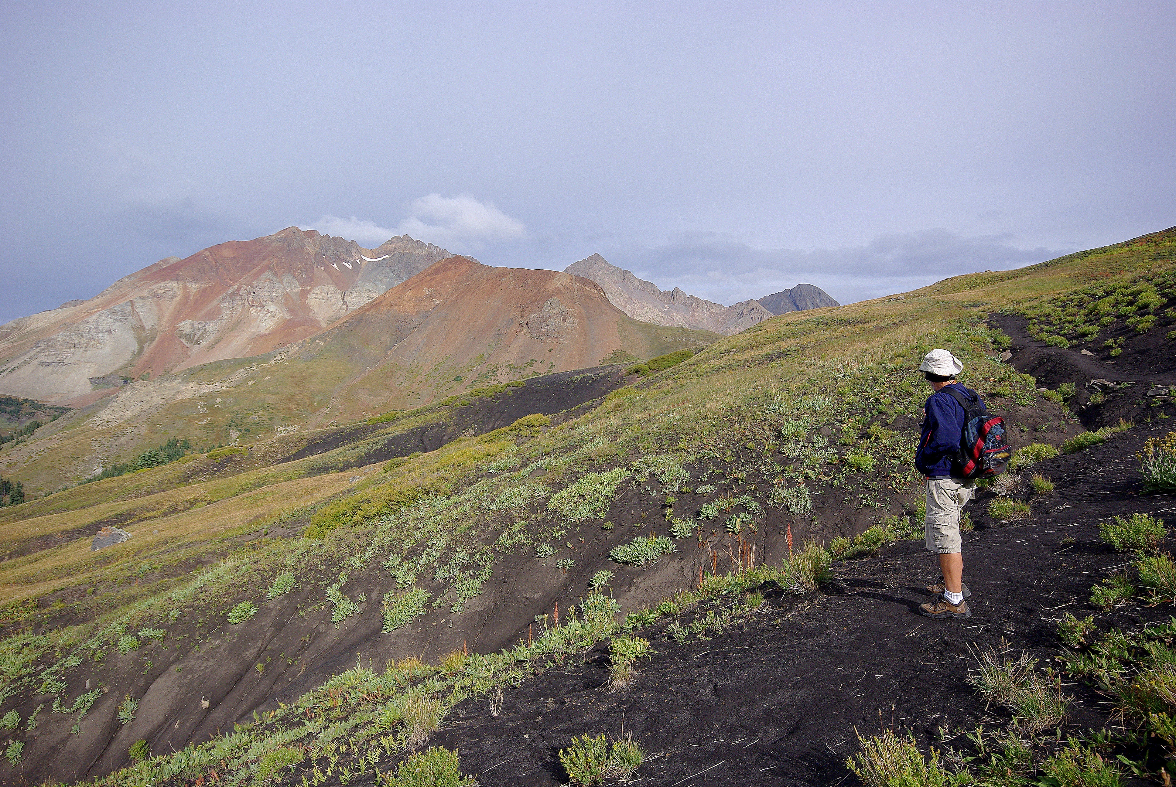
A hiker with a backpack stands on a dark, rocky trail overlooking a sweeping mountain landscape with colorful volcanic slopes.
A hiker looking out over the volcanic, high-altitude landscape of the Lizard Head Wilderness.

Lizard Head Wilderness history and protected-area timeline

Lizard Head Wilderness was formally established as a federally protected wilderness area on January 1, 1980, placing it within the early generation of U.S. Wilderness Area designations that followed the Wilderness Act framework for protecting roadless, undeveloped public lands. Its creation reflected a growing recognition of the San Juan Mountains' high-elevation landscapes as worthy of long-term preservation.

Before its designation, the lands were part of the National Forest system managed by what are today the Uncompahgre and San Juan National Forests. The wilderness status formal limits on road-building, mechanized use, and development, preserving the area's remoteness and trail-based character. The area's climbing history, particularly attempts on the unstable Lizard Head spire, has long contributed to its mystique among mountaineers, and its inclusion as a wilderness area reinforced that legacy by keeping the terrain in a largely undeveloped state.

Lizard Head Wilderness landscape and geographic character

The landscape of Lizard Head Wilderness is dominated by the high ridges and volcanic peaks of the San Juan Mountains in southwestern Colorado. Steep, exposed slopes, alpine basins, and glacial-carved valleys give the wilderness a rugged and demanding topography, with much of the terrain sitting at elevations well above timberline. Loose scree, crumbling cliffs, and resistant volcanic outcrops shape both the visual character and the difficulty of movement through the area.

The single most distinctive landform is the Lizard Head spire itself, a freestanding volcanic pinnacle reaching 13,113 feet that gives the wilderness its name. Although relatively short by the standards of nearby fourteeners, it appears dramatic because of its isolation and the vertical, unstable rock that surrounds it. Beyond the spire, the wilderness anchors a tight cluster of fourteeners, El Diente Peak at 14,159 feet, Wilson Peak at 14,017 feet, and Mount Wilson at 14,246 feet, forming one of the more concentrated groupings of high peaks in Colorado.

Drainage is anchored by the headwaters of the west fork of the Dolores River, which descends from the alpine basins of the wilderness into the broader Dolores River watershed. This combination of high peaks, volcanic spires, steep valleys, and source streams gives the wilderness a varied profile in which sharp alpine ridges transition into forested lower slopes and rocky creek corridors.

Lizard Head Wilderness ecosystems, habitats, and plant life

Lizard Head Wilderness sits within the ecological zones typical of Colorado's high San Juan Mountains, where elevation and exposure drive strong transitions between vegetation communities. Lower slopes tend to support montane and subalpine forests, while higher elevations give way to open tundra, talus slopes, and bare rock. The volcanic origins of the area mean that soils are often thin, rocky, and slow to support vegetation, particularly near the namesake spire and along the upper faces of the surrounding fourteeners.

The headwaters of the west fork of the Dolores River shape the ecological character of the lower wilderness, providing riparian habitat along otherwise arid slopes. Snowmelt-fed streams, alpine meadows in sheltered basins, and pockets of conifer forest contribute to a mosaic of habitats that, while not as biologically flashy as lower-elevation parks, support the typical high-country wildlife of the southern Rockies.

Because much of the wilderness sits at or above treeline, large portions of the land are exposed and sparsely vegetated, emphasizing geological and climatic processes over closed-canopy forest cover. This open, weather-driven landscape is central to the wild, austere feeling that defines the area.

Lizard Head Wilderness wildlife and species highlights

Wildlife in Lizard Head Wilderness reflects the species typical of Colorado's high San Juan Mountains, with mammals and birds adapted to alpine and subalpine conditions. The forested lower elevations may support deer, elk, black bears, and mountain lions, while higher basins and talus fields provide habitat for smaller mammals such as marmots, pikas, and other high-country specialists. Bighorn sheep are also present in the broader region, taking advantage of the rugged, exposed terrain.

In the air, raptors are a recurring presence, both as nesting birds on the cliffs and spires and as predators above the open ridges. The rough terrain around Lizard Head itself, while inhospitable for casual visitors, provides perches and nesting ledges that suit cliff-nesting species. Streams descending from the alpine basins add another habitat layer that supports smaller birds, invertebrates, and aquatic life typical of cold, high-elevation waterways.

Lizard Head Wilderness conservation status and protection priorities

Lizard Head Wilderness derives its conservation significance from its formal status as a designated U.S. Wilderness Area, a designation that restricts road construction, motor vehicle use, mechanized travel, and most forms of development. By keeping the area roadless and largely undeveloped, the wilderness designation protects not only scenic values but also watershed function, especially in the headwaters of the west fork of the Dolores River.

The joint administration by the Uncompahgre and San Juan National Forests places the wilderness within a larger framework of National Forest management, with the U.S. Forest Service as the governing body. This institutional structure supports ongoing stewardship of the area's sensitive alpine environments, fragile soils, and vulnerable geological features, including the unstable rock of the Lizard Head spire, where unmanaged climbing and visitor traffic could degrade both the experience and the natural fabric of the place.

Originally listed under IUCN Category Ib, the wilderness is recognized at the international level as a landscape where natural processes, ecosystem services, and minimal human interference are prioritized. Its conservation value lies as much in preserving a remote and demanding piece of the San Juan Mountains as in protecting any single charismatic species.

Lizard Head Wilderness cultural meaning and human context

Lizard Head Wilderness sits within a region of southwestern Colorado long associated with mining settlement, ranching, and small mountain communities tied to the seasonal rhythms of the high country. The nearby town of Telluride, founded as a mining camp in the late nineteenth century, reflects the broader cultural and economic history of the San Juans, even as it has shifted its identity toward tourism, skiing, and the arts.

In contemporary terms, the wilderness's cultural identity is shaped less by permanent human habitation than by the activity of climbers, backpackers, hunters, and other seasonal users who have long engaged with the area's peaks and ridges. The story of the Lizard Head spire in particular is interwoven with regional mountaineering culture, becoming a touchstone feature in discussions about the physical and technical challenges of the San Juan Mountains.

Top sights and standout views in Lizard Head Wilderness

The defining highlights of Lizard Head Wilderness cluster around a small set of dramatic features: the unstable volcanic spire of Lizard Head at 13,113 feet, the cluster of three Colorado fourteeners (El Diente Peak, Mount Wilson, and Wilson Peak), and the headwaters of the west fork of the Dolores River. Together these elements create a wilderness identity defined by high elevation, exposed terrain, and concentrated geological drama within a relatively compact area.

For visitors who are equipped for it, the wilderness offers long, demanding trails, technical alpine mountaineering, and the experience of traveling through largely unaltered San Juan mountain landscapes. Its remoteness and difficulty are themselves a highlight, preserving a kind of solitude and self-reliance that more accessible Colorado destinations often cannot match.

Best time to visit Lizard Head Wilderness

Because Lizard Head Wilderness sits at high elevation in the San Juan Mountains, summer and early autumn are the most realistic seasons for backpacking and climbing, when snow has melted from the trails and high basins and the alpine terrain is more accessible. Winter transforms the area into a deep snow environment with significant avalanche risk and very limited trail visibility, while spring brings lingering snow cover at higher elevations and unstable conditions on steep snow slopes.

Within the summer and early fall window, conditions can still shift quickly, with afternoon thunderstorms typical of the southern Rockies and sharp temperature drops above timberline. Visitors planning to attempt the Lizard Head spire or the surrounding fourteeners should expect exposed alpine conditions even in the warmer months, and should treat the area as a mountain environment rather than a casual day-use destination.
Monthly climate preview

Long-term representative temperature ranges and monthly precipitation rhythm

Lizard Head Wilderness Climate Normals and Annual Weather Patterns

Representative coordinates record sustained sub-zero winter minimums alongside warm summer daytime highs and steady precipitation across the year. Reviewing the complete twelve-month sequence reveals the full range of baseline temperature shifts and monthly precipitation variations.
Annual mean4 °C
-7 °C18 °C
Jan-7°
Feb-6°
Mar-1°
Apr
May
Jun14°
Jul18°
Aug16°
Sep12°
Oct
Nov-1°
Dec-6°
Warmest month
July

17.5 °C

Coolest month
January

-7 °C

Wettest month
August

1.8 mm/day

Driest month
June

0.7 mm/day

Park location guide

Geography guide, regional context, and park location map for Lizard Head Wilderness

Lizard Head Wilderness park geography, regions, and map view in United States of America

Understand where Lizard Head Wilderness sits in United States of America through a broader geographic reading of the surrounding landscape, nearby location context, and its mapped position within the national park landscape.

How Lizard Head Wilderness fits into United States of America

The United States of America is a federal presidential republic and one of the world's largest countries by area and population. It consists of 50 states across a vast territory spanning multiple time zones, with its capital in Washington, D.C. and largest city in New York City. The nation has a diverse economy, influential political system, and significant cultural and military presence globally.

Wider geography shaping Lizard Head Wilderness in United States of America

The United States occupies a vast territory in North America, bordered by Canada to the north and Mexico to the south. The 48 contiguous states stretch from the Atlantic to the Pacific Ocean, while Alaska occupies the northwestern region and Hawaii is an archipelago in the Pacific. The country encompasses diverse terrain including the Rocky Mountains, Appalachian Mountains, Great Plains, and extensive river systems.

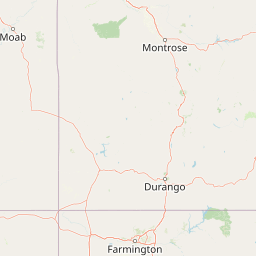
Map view of Lizard Head Wilderness

Use this park location map to pinpoint Lizard Head Wilderness in United States of America, understand its exact geographic position, and read its mapped placement within the surrounding landscape more clearly.

Pigeon | © OpenStreetMap contributors

Location context for Lizard Head Wilderness

Colorado
Recorded earthquake history

Explore Historical Earthquake Records for Lizard Head Wilderness

Review a catalog of recorded seismic events associated with the high-elevation terrain of the San Juan Mountains. This dataset offers insights into the seismic background of Lizard Head Wilderness through documented historical activity and proximity data compiled for geographic exploration.

Lizard Head Wilderness Earthquake History

Catalogued events

5 events

Strongest magnitude

Magnitude 4.4

Most recent event

Mar 10, 2023

This history includes earthquakes recorded inside the park or within 50 km of its borders

Visualizing volcanic spires, alpine basins, and rugged San Juan mountain terrain

Lizard Head Wilderness Photos and Landscape Scenery Exploration

Examine authentic field photography capturing the towering volcanic pinnacle and remote alpine ridges of Lizard Head Wilderness. Visual documentation reveals the steep topography, exposed fourteeners, and protected high-mountain habitats that define the regional landscape character.

A hiker with a backpack stands on a dark, rocky trail overlooking a sweeping mountain landscape with colorful volcanic slopes.

Park atlas

Compare regional alpine terrain and connected San Juan mountain landscapes

Parks Near Lizard Head Wilderness And Surrounding Mountain Protected Areas

Browsing protected areas near Lizard Head Wilderness reveals connected high-elevation terrain, volcanic ridges, and alpine basins across southwestern Colorado. Extending the geographic comparison into adjacent mountain reserves helps trace the broader regional spread of rugged wilderness habitats.
Protected landscapeColorado
Park boundaries overlap#1 closest

Southeast

San Juan National Forest: Geographic Overview of a Major Southern Colorado Protected Landscape

Mapped terrain across the Southern San Juan Mountains

San Juan National Forest represents a massive protected landscape in western Colorado, defined by its rugged alpine peaks, dense conifer forests, and glacial valleys. This atlas entry details the forest boundary, its position along the Continental Divide, and the surrounding transition into the Colorado Plateau. It provides a structured look at the terrain that connects diverse ecosystems, from high-altitude tundra to expansive mesa country, within one of the largest national forests in the American West.

Area
7,603.42 km²
Established
1905
Relief
Mountain
Climate
Alpine
Watercolor painting of a mountain landscape with light green rolling hills in the midground and pale, soft-toned mountain peaks in the background.
Protected areaColorado
10 km away#2 closest

Northeast

Mount Sneffels Wilderness: Mapping the High Alpine Terrain of the San Juan Mountains

Protected mountain geography in southwestern Colorado

Mount Sneffels Wilderness protects a dramatic cluster of peaks in the San Juan range, characterized by glacial cirques, expansive talus fields, and sharp ridgelines. As a vital component of the Colorado backcountry, this area provides a window into high-altitude ecological transition zones, from dense conifer forests to exposed granite summits that define the character of the Uncompahgre National Forest.

Area
67.04 km²
Established
1980
IUCN
Ib
Relief
Mountain
Protected landscapeColorado
About 16 km away#3 closest

Northeast

Uncompahgre National Forest: Protected Landscapes and Geographic Features in Colorado

Mapping the arid plateau and high-country San Juan wilderness zones.

Uncompahgre National Forest represents a vast protected area in the American West, spanning iconic landscapes from the dry, pinyon-juniper covered Uncompahgre Plateau to the dramatic, jagged ridges of the northern San Juan Mountains. This atlas entry provides essential context on its alpine wilderness designations, high-country topography, and the unique geological transitions that define its status as a critical Colorado resource for regional landscape analysis.

Area
3,865.68 km²
Established
1905
Relief
Mountain
Climate
Alpine
Watercolor painting of soft, layered mountain ranges behind green hills and patches of evergreen trees on a white background.
Protected landscapeColorado
30 km away#4 closest

East

Rio Grande National Forest: Atlas and Geographic Profile of a Southern Colorado Landscape

Watershed geography and Continental Divide terrain analysis.

Rio Grande National Forest represents an immense protected landscape encompassing diverse terrain from high desert steppe to rugged alpine peaks. This profile details the forest's hydrological significance as the source of the Rio Grande and its role as a massive ecological transition zone in the Mountain West. Examine the boundaries and mountain geography that define this critical protected area.

Area
7,500 km²
Established
1908
Relief
Mountain
Climate
Boreal
National parkMontezuma County
57 km away#5 closest

Southwest

Mesa Verde National Park: Protected Landscape Atlas and Geographic Identity

Discover the mapped terrain and regional context of this national park.

Mesa Verde National Park serves as a critical protected landscape within Montezuma County, offering distinct insights into regional geography and mapped terrain. This entry details the park's identity as a National Park, emphasizing its geographic setting and providing a foundation for atlas-driven exploration. Understand the park's place within the broader landscape context and its significance as a mapped protected area, ideal for focused geographic study.

Area
212.4 km²
Established
1906
IUCN
II
Visitors
463.1K annual
A horizontal watercolor painting depicting soft green rolling hills and distant mountains under a white sky.
Wildlife reserveColorado
61 km away#6 closest

East

Powderhorn Wilderness: A High-Elevation Protected Landscape in the San Juan Mountains

Basaltic plateaus and vast alpine tundra in Colorado

Powderhorn Wilderness protects a distinct highland environment in southwestern Colorado. Characterized by dark basaltic caprocks and deep glacial cirques, this area serves as a critical headwaters system for the Gunnison River, supporting a complex transition from sagebrush steppe to subalpine forest and wind-swept tundra. The geography remains largely defined by its volcanic heritage and the primitive character of its remote plateau summits.

Area
251.1 km²
Established
1993
IUCN
Ib
Relief
Mountain
A pale watercolor painting showing a panoramic view of mountain ranges in the background, a coniferous forest on a small hill, and a meadow with wildflowers in the foreground.
Wildlife reserveColorado
64 km away#7 closest

East

La Garita Wilderness: Exploring the High Alpine Geography of Southern Colorado

Volcanic terrain and protected mountain wilderness atlas

La Garita Wilderness serves as a primary example of protected high-alpine geography in southern Colorado. This atlas entry examines the undulating volcanic ridges, glacial cirques, and alpine basins that define the area, including the prominent peak of San Luis. It highlights the integration of significant trail systems within this protected landscape, offering a clear perspective on the physical geography and conservation value of the La Garita mountain range.

Area
524.58 km²
Established
1964
IUCN
Ib
Relief
Mountain
National parkMontrose County
72 km away#8 closest

North

Black Canyon of the Gunnison National Park: Protected Area Geography and Mapped Landscape

Explore the natural terrain and protected boundaries in Montrose County.

Black Canyon of the Gunnison National Park is a national park defined by its profound geological features and its status as a protected landscape. Located within Montrose County, it offers a distinct geographic profile for atlas-based exploration. Users can understand the park's mapped boundaries, its relation to the surrounding regional geography, and the unique natural terrain that defines this protected area, contributing to a structured discovery of its natural landscape identity.

Area
124.4 km²
Established
1999
IUCN
II
Visitors
357.1K annual

Common questions about visiting, size, designation, and location context for Lizard Head Wilderness

Lizard Head Wilderness FAQs for park facts, access, geography, and protected area context

Find quick answers about Lizard Head Wilderness, including protected-area facts, park geography, trail and visitor context, and how the park fits into its surrounding country and regional landscape.
MoriAtlas Explorer

Continue Your Protected Areas Search Across the Global Atlas

Deepen your exploration by continuing the structured search for national parks and protected areas worldwide. Utilize the comprehensive filtering capabilities to compare different conservation landscapes and refine your understanding of global park geography. Discover more about the distribution and characteristics of protected natural areas.

Global natural geography