Mori Atlas logo
Marine protected areaLong Island-Kokomohua Marine Reserve

Understanding the ecological significance of reef systems in the Marlborough Region

Long Island-Kokomohua Marine Reserve: A Detailed Atlas of Protected Marine Landscapes

Long Island-Kokomohua Marine Reserve represents a vital protected landscape at the entrance to Queen Charlotte Sound, serving as a landmark temperate marine ecosystem in the Marlborough Region. This atlas entry details the submerged reef terrain, island boundaries, and rocky pinnacles that define its underwater topography. Research within these protected waters offers insights into the recovery of reef species and the resilience of temperate marine food webs across the South Island.

marine reserveMarlborough SoundsQueen Charlotte Soundreef ecosystemisland reservebird sanctuary

Long Island-Kokomohua Marine Reserve

Marine protected area

Park overview

Structured park overview, official facts, and landscape profile for Long Island-Kokomohua Marine Reserve

Long Island-Kokomohua Marine Reserve park facts, protected area profile, and essential visitor context

Review the core facts for Long Island-Kokomohua Marine Reserve, including designation, size, terrain, visitor scale, habitats, and operating context in one park-focused overview.

About Long Island-Kokomohua Marine Reserve

Long Island-Kokomohua Marine Reserve protects a compact but biologically rich slice of coastal New Zealand at the mouth of Queen Charlotte Sound. Located in the Marlborough Region of the South Island, the reserve straddles the transition between the sheltered, intricate waterways of the Marlborough Sounds and the more open, current-swept waters of the outer coast. Its 619 hectares incorporate Long Island, the small Kokomohua Islands to the north, and a largely submerged reef that ties the islands together before extending northeast into deeper water, where isolated rocky pinnacles rise from the seabed.

Administratively the reserve is managed by the New Zealand Department of Conservation, and its establishment in March 1993 made it the first marine reserve of its kind on the South Island. From the outset, both commercial and recreational fishing were excluded from its waters, transforming what had been a fished coastline into a reference site for understanding how New Zealand's temperate reef ecosystems function without extractive pressure. This protective status has shaped both the marine communities that now live within the reserve and the scientific record that has grown up around it.

The reserve's significance extends well beyond its modest size. Long-term monitoring by the Department of Conservation and the National Institute of Water and Atmospheric Research has turned the area into one of the best-documented examples of marine ecosystem recovery in the country, while its proximity to Picton makes it a focal point for boating, snorkeling, and diving within the Marlborough Sounds. The interplay of accessible shallows, deeper rocky pinnacles, and a connected reef system gives the reserve a layered habitat structure that supports everything from reef-associated fish to seabirds and marine mammals feeding offshore.

Quick facts and research context for Long Island-Kokomohua Marine Reserve

Long Island-Kokomohua Marine Reserve lies in the Marlborough Region, at the seaward entrance to Queen Charlotte Sound within the larger Marlborough Sounds system. It is administered by the New Zealand Department of Conservation and covers 619 hectares. The reserve protects Long Island and the small Kokomohua Islands, along with a connecting reef and a string of deeper-water rocky pinnacles to the northeast. It was established in March 1993 as the first marine reserve on New Zealand's South Island, and has since served as a key reference site for understanding temperate marine ecosystem recovery after fishing is halted.

Protection and recognition

Examine the documented marine protection scope and official conservation framework

Long Island-Kokomohua Marine Reserve Protection Status and Governance Data

Long Island-Kokomohua Marine Reserve maintains a documented marine protection scope within its designated conservation framework. Structured records outline the established management boundaries and international recognition details for this protected area.

Protection details

Protection scope
Marine
Transboundary protection
No
Park context

Deeper park guide and search-rich context for Long Island-Kokomohua Marine Reserve

Long Island-Kokomohua Marine Reserve history, landscape, wildlife, and travel context

Explore Long Island-Kokomohua Marine Reserve through its history, landscape character, ecosystems, wildlife, conservation priorities, cultural context, and seasonal travel timing in a structured park guide built for atlas discovery and search intent.

Why Long Island-Kokomohua Marine Reserve stands out

The reserve is best known as the South Island's first marine reserve, and as a clear demonstration of how a temperate coastal ecosystem rebounds once fishing pressure is removed. Within a few years of establishment, predatory fish such as blue cod multiplied dramatically, rock lobster populations multiplied by more than ten times, and grazing sea urchins fell sharply, signaling a return to a more balanced food web. The combination of a sheltered island setting, a partially submerged reef, and deeper rocky pinnacles also makes it a recognizable reference site for divers studying reef ecology in the Marlborough Sounds.
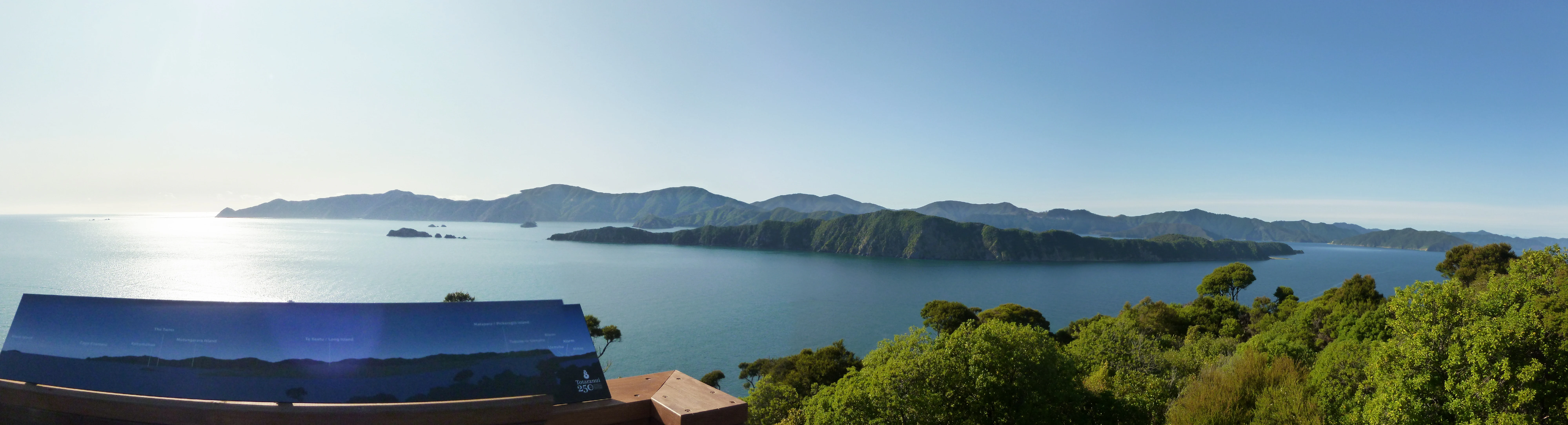
A wide panoramic photograph showing a calm body of water with a long, hilly, tree-covered island in the distance under a clear blue sky, viewed from a high vantage point with a dark interpretive sign in the foreground.
A panoramic view of Long Island in the Marlborough Sounds.

Long Island-Kokomohua Marine Reserve history and protected-area timeline

The story of the reserve begins on land rather than at sea. In 1925, a ranger visited Long Island and recommended that it be set aside for protection, and a scenic reserve was declared the following year. For decades the small island at the entrance to Queen Charlotte Sound remained a modest land-based reserve while the surrounding waters continued to be fished.

In 1991, local divers brought attention to the marine environment around the island and proposed that it be given formal marine reserve status. Commercial and recreational fishing were halted in 1992 in preparation for that change, and in March 1993 the Long Island-Kokomohua Marine Reserve was formally established as the first marine reserve on New Zealand's South Island.

From that point the reserve evolved into a long-term monitoring site. A Department of Conservation study in March 2011 recorded more large blue cod than at any point in the previous seventeen years, and a 2014 study found that marine life within the reserve had become larger, more abundant, more widely distributed, and had shifted in both structure and behavior. A 2016 report by the National Institute of Water and Atmospheric Research documented a dramatic recovery of fish stocks following the end of fishing, with rock lobster increasing more than elevenfold and blue cod trebling in number. By July 2020, researchers using the reserve as a reference site identified microplastics on its seafloor, extending the reserve's role from a recovery case study to a baseline for emerging marine pollution concerns.

Long Island-Kokomohua Marine Reserve landscape and geographic character

The reserve sits at a visually striking transition zone where the deeply indented, island-dotted Marlborough Sounds meet the more open approaches to the outer coast. Its surface landscape is dominated by Long Island itself, a green, hilly island anchored at the entrance to Queen Charlotte Sound, with the much smaller Kokomohua Islands clustered to its north. Viewed from neighboring Motuara Island, Long Island presents the wooded ridgelines typical of the Marlborough Sounds.

Beneath the surface, the defining landscape feature is a largely submerged reef that runs between the islands. About 500 meters of this reef is incorporated into the reserve, after which the protected area extends a further 463 meters to the northeast, encompassing a series of isolated rocky pinnacles rising from deeper water. The combination of sheltered near-shore reef, connecting shallows, and exposed deeper pinnacles creates a varied underwater terrain that supports very different communities across relatively short distances.

The surrounding waters are influenced by the tidal flows of Queen Charlotte Sound and by prevailing conditions in the Cook Strait region. Weather and sea conditions can shift quickly, and the area is known for strong currents, sudden wind changes, and tidal swings, all of which shape both the physical environment and how the reserve can be experienced from the surface.

Long Island-Kokomohua Marine Reserve ecosystems, habitats, and plant life

The ecosystem protected by the reserve reflects its position at the boundary between sheltered sound environments and the more dynamic outer Marlborough Sounds coastline. Reef structures within the reserve support mixed communities of seaweed, sea sponges, and reef-associated invertebrates, while the deeper rocky pinnacles to the northeast provide habitat in a colder, more current-swept setting.

At a broader scale, the reserve sits within the temperate marine environment characteristic of the northern South Island, where seasonal productivity pulses drive cycles of growth and reproduction in fish, shellfish, and the species that feed on them. The combination of protected shallow reef and deeper rocky habitat creates a layered ecological system, with different zones favoring different species. This structural diversity is what allows the reserve to support not only a dense reef fish community but also the larger predators, marine mammals, and seabirds that rely on these waters for food.

The reserve's long exclusion of fishing has allowed the natural trophic structure of the ecosystem to reassert itself. Predatory fish, grazing invertebrates, and kina have settled into new balances that more closely reflect the underlying productivity of the habitat rather than the legacy of extraction, making the area an unusually intact example of temperate New Zealand coastal ecology.

Long Island-Kokomohua Marine Reserve wildlife and species highlights

Wildlife within the reserve centers on a thriving reef fish community. Large blue cod are notably abundant, and the rocky pinnacles in particular attract schools of butterfly perch and tarakihi, along with rock lobster, blue cod, and a rich understorey of seaweed and sea sponges. Larger marine animals also make use of the area, with both dolphins and seals recorded in reserve waters.

Above and around the islands, the reserve supports seabirds and penguins that feed at sea. In January 2022, fifty fluttering shearwater, known in te reo Māori as pakahā, chicks were translocated from the reserve to the newly established Wharariki Ecosanctuary at Cape Farewell, becoming the first species to be introduced to that new sanctuary and highlighting the importance of the reserve as a source population for seabird restoration further afield.

On the seabed, the balance between grazers and predators has shifted noticeably since protection. Grazing kina, particularly small individuals, declined to roughly one third of pre-reserve levels, while predatory blue cod trebled, blue moki increased by around 1.4 times, and rock lobster populations multiplied by more than eleven times. These shifts reflect both the natural productivity of the reef and the removal of fishing pressure, and they have made the reserve a widely cited example of marine trophic recovery.

Long Island-Kokomohua Marine Reserve conservation status and protection priorities

The reserve is significant both as a protected area in its own right and as a long-term ecological reference site for the wider Marlborough Sounds and New Zealand coastal waters. By removing commercial and recreational fishing from its 619 hectares, it has allowed a temperate reef ecosystem to rebound in ways that are now unusually well documented. Studies across multiple decades have shown clear increases in the size, abundance, and distribution of marine life, along with changes in behavior that suggest the community is functioning more like a natural system than a fished one.

Beyond its local importance, the reserve has played an outsized role in shaping understanding of marine conservation in New Zealand. Its dramatic recovery of predatory fish and shellfish, and the concurrent decline of grazing kina, has been cited as evidence of ecosystem resilience and of the potential for restoration in areas currently outside formal protection. The reserve also serves as a baseline for newer concerns, including the detection of microplastics on its seafloor, which positions it as a reference point for tracking emerging pollution impacts in otherwise healthy temperate reef systems.

Long Island-Kokomohua Marine Reserve cultural meaning and human context

The reserve overlaps with traditional Māori interests in the Marlborough Sounds. While general fishing and the taking of marine life are not permitted within its boundaries, tangata whenua retain the right to access the reserve for the removal of nephrite and serpentine, reflecting the continuing cultural and material significance of these stone resources to local iwi. The use of the Māori name pakahā for the fluttering shearwater in official documentation also acknowledges the linguistic and cultural heritage of the region in which the reserve sits.

Top sights and standout views in Long Island-Kokomohua Marine Reserve

Six hundred and nineteen hectares of protected temperate reef at the entrance to Queen Charlotte Sound, including Long Island and the Kokomohua Islands. A largely submerged reef system that extends northeast into deeper water, terminating in rocky pinnacles that concentrate reef fish and invertebrates. The first marine reserve established on New Zealand's South Island, and one of the country's best-documented examples of marine ecosystem recovery following the removal of fishing pressure. Dramatic documented rebounds in rock lobster, blue cod, and other species, alongside reduced grazing pressure from kina, illustrating the resilience of temperate reef food webs. A source population for seabird restoration, including the translocation of fluttering shearwater chicks to other protected sites. A living baseline for emerging issues such as microplastic accumulation on otherwise healthy reef seafloors.
Monthly climate preview

Long-term representative temperature and monthly precipitation averages for Marlborough Region

Long Island-Kokomohua Marine Reserve Climate Normals and Annual Weather Patterns

Representative coordinate records show mean monthly temperatures ranging from 10.64 degrees Celsius to 17.44 degrees Celsius alongside steady precipitation values between 1.85 and 3.16 millimeters per day. Reviewing the complete twelve-month profile provides deeper insight into long-term climate normals across the marine reserve.
Annual mean14 °C
11 °C17 °C
Jan17°
Feb17°
Mar16°
Apr15°
May13°
Jun12°
Jul11°
Aug11°
Sep11°
Oct13°
Nov14°
Dec15°
Warmest month
February

17.4 °C

Coolest month
July

10.6 °C

Wettest month
June

3.2 mm/day

Driest month
January

1.9 mm/day

Park location guide

Geography guide, regional context, and park location map for Long Island-Kokomohua Marine Reserve

Long Island-Kokomohua Marine Reserve park geography, regions, and map view in New Zealand

Understand where Long Island-Kokomohua Marine Reserve sits in New Zealand through a broader geographic reading of the surrounding landscape, nearby location context, and its mapped position within the national park landscape.

How Long Island-Kokomohua Marine Reserve fits into New Zealand

New Zealand is an island nation in the southwestern Pacific Ocean comprising two main islands and numerous smaller islands. Located east of Australia across the Tasman Sea, it features varied topography with the Southern Alps running along the South Island and volcanic terrain on the North Island. The country was settled by Maori people between 1280 and 1350, followed by European exploration beginning in 1642, and became a Dominion in 1907 before gaining full independence in 1947.

Wider geography shaping Long Island-Kokomohua Marine Reserve in New Zealand

New Zealand lies in the southwestern Pacific Ocean, east of Australia across the Tasman Sea. The country consists of two main islands, the North Island and South Island, plus over 600 smaller islands. The North Island features volcanic plateaus and hills while the South Island is dominated by the Southern Alps mountain range. The country has a long coastline and is surrounded by the Pacific Ocean.

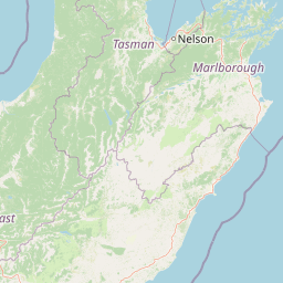
Map view of Long Island-Kokomohua Marine Reserve

Use this park location map to pinpoint Long Island-Kokomohua Marine Reserve in New Zealand, understand its exact geographic position, and read its mapped placement within the surrounding landscape more clearly.

Pigeon | © OpenStreetMap contributors

Location context for Long Island-Kokomohua Marine Reserve

Marlborough Region
Recorded earthquake history

Review the Recorded Earthquake History for Long Island-Kokomohua Marine Reserve

MoriAtlas maintains an archival collection of seismic activity documented near the Long Island-Kokomohua Marine Reserve. Examine historical event data, including epicentre proximity and magnitude, to understand the documented seismic context of the Marlborough Region marine protected area.

Long Island-Kokomohua Earthquake History

Catalogued events

259 events

Strongest magnitude

Magnitude 5.8

Most recent event

Jul 31, 2026

This history includes earthquakes recorded inside the park or within 50 km of its borders

Visual reference of protected coastal terrain, reef habitats, and island topography

Long Island-Kokomohua Marine Reserve Photos and Landscape Scenery

Visual documentation captures the varied coastal terrain and submerged reef systems defining Long Island-Kokomohua Marine Reserve. Photographic records help researchers and observers interpret temperate marine habitats and protected island topography across Queen Charlotte Sound.

A wide panoramic photograph showing a calm body of water with a long, hilly, tree-covered island in the distance under a clear blue sky, viewed from a high vantage point with a dark interpretive sign in the foreground.

Park atlas

Compare nearby coastal reserves and connected marine landscapes across the Marlborough Region

Parks Near Long Island-Kokomohua Marine Reserve and Surrounding Protected Areas

Browse other parks near Long Island-Kokomohua Marine Reserve to compare temperate reef ecosystems and protected coastlines across the surrounding region. Extending your geographic comparison reveals how adjacent island habitats and marine reserves shape regional conservation patterns.
A horizontal watercolor illustration depicting rolling green hills, scattered trees, and soft, muted tones against a plain white background.
Nature reserveMarlborough Sounds
About 1.8 km away#1 closest

North

Motuara Island Nature Reserve: Protected Landscape and Geographic Discovery

Marlborough Sounds Coastal Reserve and Sanctuary

Motuara Island is a significant nature reserve characterized by its regenerating forest, rugged coastline, and elevated summit lookout. Serving as a sanctuary for native birds and a landmark of colonial and Māori history, this 59-hectare island remains a central point of geographic interest within the Marlborough Sounds ria system.

Area
0.59 km²
Established
1976
Relief
Upland
Climate
Temperate
Protected landscapeMarlborough Region
31 km away#2 closest

Southwest

Mount Richmond Forest Park: Geography and Protected Landscapes in the Marlborough Region

Expansive native bush and mountain peak terrain

Mount Richmond Forest Park stands as one of the largest protected forest areas on the South Island of New Zealand. Dominated by dense native bush and rugged subalpine ridges, the park offers a complex topography of river valleys and high-altitude peaks, including its namesake Mount Richmond. It serves as a vital conservation landscape and a core segment of the regional geography between Nelson and the Marlborough district.

Area
1,659 km²
Established
1977
Relief
Mountain
Scope
Terrestrial
Nature reserveNew Zealand
About 34 km away#3 closest

West

Maud Island Nature Reserve: Geographic Overview and Protected Coastal Landscape

A pivotal conservation sanctuary in the Marlborough Sounds region

Maud Island represents a critical protected area in the Pelorus Sound of New Zealand. Defined by 320 hectares of forested, hilly terrain and a unique narrow isthmus, the island serves as a foundational refuge for species recovery. Its sheltered maritime setting makes it a key feature of the Marlborough Sounds geography and an essential location for scientific ecological research.

Area
3.2 km²
Established
1971
Relief
Upland
Climate
Temperate
Nature reserveWellington
About 43 km away#4 closest

Southeast

Te Kopahou Reserve: Nature Reserve Geography and Coastal Landscapes in Wellington

A rugged intersection of forested hills, ridgelines, and coastal cliffs.

Situated on the southern edge of Wellington, Te Kopahou Reserve offers a diverse protected landscape ranging from the summit of Hawkins Hill to the iconic red rocks of the Cook Strait shoreline. This nature reserve provides a critical geographic transition, hosting regenerating native bush, exposed ridgeline trails, and vital habitats for local wildlife, making it a prominent example of regional conservation land on the North Island of New Zealand.

Area
6 km²
Relief
Mountain
Climate
Temperate
Access
Easy access
Protected landscapeWellington Region
43 km away#5 closest

East

Whitireia Park: Coastal Headland and Protected Landscape in the Wellington Region

Explore mapping of coastal terrain, forests, and harbour boundaries.

Whitireia Park is a prominent coastal reserve in the Wellington Region that balances deep Ngāti Toa cultural significance with a unique geological history shaped by centuries of earthquake uplift. The headland features open grasslands, remnant kohekohe forest, and ongoing wetland restoration that offers a layered view of New Zealand's natural and social history across its accessible harbour-edge geography.

Area
1.8 km²
Established
1976
Relief
Upland
Climate
Temperate
Nature reserveMarlborough Region
About 54 km away#6 closest

Northwest

Stephens Island (New Zealand) Nature Reserve: Geography and Protected Land Overview

Maritime sanctuary and ecological refuge in Marlborough Region

Stephens Island (New Zealand) acts as a rugged, compact island refuge in the Cook Strait, defined by steep terrain rising to 283 metres. As a critical nature reserve managed by Ngāti Koata and the Department of Conservation, this site offers profound insights into isolated island ecosystems, evolutionary endemic species, and the geological processes of the Maitai Group.

Area
1.5 km²
Established
1966
Relief
Upland
Climate
Temperate
Regional parkWellington Region
About 59 km away#7 closest

East

Wainuiomata Regional Park: Geography and Protected Area Atlas

River valley terrain in the Wellington Region

Wainuiomata Regional Park is a protected river valley setting featuring significant lowland native forest, historic water infrastructure, and restored wetland habitats. This landscape provides a critical link in the conservation geography of the Wellington Region, connecting to extensive forest remnants and supporting a variety of native ecosystems within the Wainuiomata catchment.

Relief
Mixed relief
Water
Major water bodies
Wildlife reserveWellington Region
About 61 km away#8 closest

East

Wainuiomata Water Collection Area: Protected Forest Terrain and Wellington Catchment Geography

Mapping the native forest canopy and river catchments of New Zealand.

The Wainuiomata Water Collection Area remains a vital conservation landscape, preserving deep river valleys and mature podocarp-broadleaf forest within the Wellington Region. This wildlife reserve functions as a major ecological hub, featuring continuous native bush that supports intensive predator control and species recovery efforts. Its geographic integrity provides a unique perspective on protected catchment management and pristine lowland wilderness in the southern North Island.

Water
Major water bodies

Common questions about visiting, size, designation, and location context for Long Island-Kokomohua Marine Reserve

Long Island-Kokomohua Marine Reserve FAQs for park facts, access, geography, and protected area context

Find quick answers about Long Island-Kokomohua Marine Reserve, including protected-area facts, park geography, trail and visitor context, and how the park fits into its surrounding country and regional landscape.
MoriAtlas Explorer

Continue Your Protected Areas Search Across the Global Atlas

Deepen your exploration by continuing the structured search for national parks and protected areas worldwide. Utilize the comprehensive filtering capabilities to compare different conservation landscapes and refine your understanding of global park geography. Discover more about the distribution and characteristics of protected natural areas.

Global natural geography