Why Lower Kaduna-Middle Niger Floodplain stands out
The region is best known as one of Nigeria's most extensive floodplain wetlands, where the Niger and Kaduna rivers overflow across flat terrain to form seasonally flooded fadama lands, swamps, and shallow lakes. It stands out for its Ramsar designation within the Guinea savanna, its prior recognition as an Important Bird Area, and its role as the core zone of a wetland system that connects the Bauchi Plateau, the Yoruba highlands, and the southern rainforest zone along the Niger River. The floodplain is also notable for its gallery forests, aquatic plant communities, and the seasonal rhythms of the so-called 'white flood' and 'black flood' that define its hydrology.
Lower Kaduna-Middle Niger Floodplain history and protected-area timeline
The Lower Kaduna-Middle Niger Floodplain gained formal recognition as a globally important wetland on 30 April 2008, when it was inscribed on the list of Ramsar Wetlands of International Importance. This designation reflected the site's ecological value within the Guinea savanna ecoregion and built on its earlier identification as an Important Bird Area, which had highlighted its importance for breeding and migratory birds long before the Ramsar listing was awarded.
Since the 1970s, the site has experienced significant hydrological change following the construction of the Kainji and Shiroro dams upstream on the Niger and Kaduna rivers. These dams altered the natural flood pulse of the system, reducing the extent of flooded areas and weakening the regeneration processes of the floodplain, which depend on seasonal erosion and sediment deposition. The Ndakolowu Lake, once covering around 12 square kilometres northeast of Jebba, shrank to a few residual pools by the 1990s as a consequence of these altered dynamics, allowing Guinea savanna vegetation to encroach on former wetland habitats.
Alongside these hydrological changes, the surrounding region has seen substantial population growth and the intensification of agriculture, particularly rice and sugarcane cultivation, in the fertile fadama lands. The interplay of upstream dam control, expanding farmland, and shifting vegetation patterns has shaped the modern character of the floodplain and continues to influence its conservation management and future trajectory.
Lower Kaduna-Middle Niger Floodplain landscape and geographic character
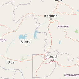
The landscape of the Lower Kaduna-Middle Niger Floodplain is defined by broad, flat alluvial terrain at about 130 meters above sea level, traversed by two major rivers, the Niger and the Kaduna. The Niger flows through the protected area between Jebba and Baro, while the Kaduna section extends inland from around the Wuya Bridge along the A1 highway toward Pategi and Bida. Wide floodplain flats dominate the view wherever the rivers leave the higher ground.
Along the river channels, the scenery alternates between long stretches of sandbanks and rapids and dramatic sections where the rivers are framed by kilometre-long cliffs. Where flooding spreads beyond the channels, the terrain becomes a mosaic of wetlands, shallow swamps, ponds, shallow lakes, and seasonally inundated grasslands. These flooded zones are known locally as 'fadama' in Hausa. The dramatic seasonal rhythm of the landscape, from the broad inundation of the rainy season to the receding waters and exposed banks of the dry months, gives the floodplain a continually shifting character throughout the year.
Geologically, the floodplain sits on alluvial sediment layers that overlie Cretaceous-era Nupe sandstone. The natural cycle of erosion along the rivers and sediment deposition across the floodplain during the annual flood keeps these soils renewable, but upstream dam regulation has altered this cycle visibly, reducing both the extent of the flooded area and the ability of parts of the floodplain to benefit fully from the flood pulse. Today, the floodplain represents a transitional landscape between the Bauchi Plateau in the east, the Yoruba highlands in the west, and the rainforest zone further south along the Niger, making it a key low-lying corridor in central Nigeria's regional geography.
Lower Kaduna-Middle Niger Floodplain ecosystems, habitats, and plant life
Ecologically, the Lower Kaduna-Middle Niger Floodplain lies within the Guinea savanna ecoregion, where seasonal flooding creates an unusually rich and dynamic habitat mosaic. Despite being surrounded by savanna, the floodplain itself consists of wetland ecosystems more typical of larger flood systems: gallery forests, swamps, pools, seasonal lakes, and extensive aquatic plant communities. This juxtaposition of dryland savanna and permanent or seasonal water bodies gives the area its ecological identity.
Along the riverbanks and in intact floodplain areas, gallery forests form a continuous green corridor, with Mitragyna inermis emerging as a dominant tree species. These forests contrast sharply with the surrounding open savanna and provide refuge for forest-associated species well outside the southern rainforest belt. On open water surfaces and along shorelines, aquatic plants such as Nymphaea lotus, Echinochloa pyramidalis, Echinochloa stagnina, Cyperus papyrus, and Vossia cuspidata form dense mats that support both aquatic fauna and breeding birds.
The broader wetland complex of which the floodplain is the core zone extends from the Bauchi Plateau in the east to the Yoruba highlands in the west, and along the Niger River into the southern rainforest zone. This makes the floodplain an important connecting element between otherwise very different ecological regions. However, hydrological changes since the 1970s, including altered flood timing and a reduced flooded area, have allowed typical Guinea savanna flora to expand into former wetland zones, gradually shifting the balance of habitats in parts of the floodplain.
Lower Kaduna-Middle Niger Floodplain wildlife and species highlights
The Lower Kaduna-Middle Niger Floodplain is particularly significant for its birdlife, which is the reason the area was originally identified as an Important Bird Area before its Ramsar designation. Roughly fifteen threatened bird species are recorded as breeding in the floodplain, making it one of the more important breeding strongholds for vulnerable species within the Guinea savanna.
Among the most notable bird species is the Rosy Bee-eater, Merops malimbicus, with large flocks of around 15,000 individuals documented during counts in 1989 and 1996. Other characteristic or notable species recorded here include the Black-throated Honeyguide (Indicator indicator), Hartlaub's Duck (Pteronetta hartlaubii), the Bush Sparrow (Petronia dentata), the Black-rumped Waxbill (Estrilda troglodytes), and the Piping Hornbill (Bycanistes fistulator). Together these and other species reflect the site's importance for both resident and seasonally occurring bird populations.
The floodplain's freshwater habitats also support a diverse fish fauna. Important species in or along the river channels belong to genera such as Gymnarchus, Clarias, and Heterotis, as well as the large-bodied Lates, commonly known as the Nile perches or giant perches. In the floodplain wetlands themselves, species such as the Vundu catfish (Heterobranchus longifilis), electric catfish of the genus Malapterurus, and fishes of the subfamilies Auchenoglanidinae and the families Claroteidae and Distichodontidae are recorded. The combination of large rivers, seasonally flooded plains, and gallery forest edges creates a varied habitat structure that sustains both aquatic and semi-aquatic wildlife throughout much of the year.
Lower Kaduna-Middle Niger Floodplain conservation status and protection priorities
The conservation significance of the Lower Kaduna-Middle Niger Floodplain rests on its formal recognition as a Ramsar Wetland of International Importance, gained on 30 April 2008. This designation placed the site within a global framework for the protection of wetlands of outstanding ecological, hydrological, or ornithological value, and underlined its role as a core zone of a much larger wetland system linking the Bauchi Plateau, the Yoruba highlands, and the southern rainforest zone along the Niger River.
Beyond its global recognition, the floodplain's status as an Important Bird Area underscored its importance for breeding populations of threatened bird species long before the Ramsar listing, giving the area a long-standing profile in bird conservation. Its rich fish fauna and its gallery forests, which support Mitragyna inermis as a dominant tree species, add further ecological weight to the site's conservation value.
However, the conservation context is shaped by significant pressures. The construction of the Kainji and Shiroro dams upstream altered the natural flood pulse and reduced the extent of inundated areas from the 1970s onward, affecting the regeneration of wetlands such as the Ndakolowu Lake, which shrank from around 12 square kilometres to scattered pools. The expansion of rice and sugarcane cultivation across the fertile fadama lands, alongside population growth, adds further pressure on natural habitats and seasonal flooding patterns. These dynamics highlight why the floodplain's conservation future depends not only on its protected status but also on managing upstream water flows and the agricultural expansion of the surrounding region.
Lower Kaduna-Middle Niger Floodplain cultural meaning and human context
The Lower Kaduna-Middle Niger Floodplain sits in a region whose local culture, language, and livelihood patterns are closely tied to the rivers and the seasonal flood. The Hausa term 'fadama', used to describe the seasonally flooded lands along the Niger and Kaduna, reflects how deeply this hydrological cycle is embedded in everyday language and rural land use across central Nigeria.
The fertile floodplain zone is a major agricultural area for the surrounding communities, especially for the cultivation of rice and sugarcane, which draw on the moisture and alluvial soils of the flooded lands. Riverside settlements and markets, including nearby towns such as Pategi, Gbako, Ilorin, and Minna, are linked to the floodplain not only economically but also culturally, as the rhythm of the 'white flood' and 'black flood' shapes agricultural calendars, fishing activities, and travel along the river corridors. While the source material does not detail specific ethnic or religious traditions, the naming conventions and settlement patterns make it clear that human life around the floodplain is organized around its seasonal hydrology.
Top sights and standout views in Lower Kaduna-Middle Niger Floodplain
The Lower Kaduna-Middle Niger Floodplain stands out as one of Nigeria's largest floodplain wetland complexes, where the Niger and Kaduna rivers create a seasonal mosaic of swamps, lakes, sandbanks, and gallery forests within the Guinea savanna. Its dual recognition, first as an Important Bird Area and then as a Ramsar site in 2008, places it firmly among the country's most important sites for threatened breeding birds and wetland biodiversity. The local Hausa concept of 'fadama' captures the intimate cultural and agricultural relationship between the rivers and the people who farm their banks.
Best time to visit Lower Kaduna-Middle Niger Floodplain
Experiencing the Lower Kaduna-Middle Niger Floodplain is shaped strongly by the annual flood cycle. From August to October the rainy season drives the rising 'white flood', which by November has spread across the fadama lands, transforming the floodplain into an extensive wetland. Water levels peak in February during the so-called 'black flood', when clearer Niger water dominates the system, and then gradually recede until July, when levels are at their lowest.
Wildlife viewing, particularly birdwatching, is linked to these seasonal dynamics. Large flocks of Rosy Bee-eaters and other breeding birds have been recorded during periods when the wetlands are at their most extensive, while the dryer months expose sandbanks and shallower water bodies that favour other forms of observation. Travellers interested in seeing the broader wetland landscape at its fullest tend to favour the later rainy season and early dry season, whereas those drawn to clearer, more open waters may prefer the months around the peak of the 'black flood' in February.