
Mori Atlas logo
Protected landscapeLyndon B. Johnson National Grassland

Understanding the rolling prairie terrain and multiple-use geography of northern Texas

Lyndon B. Johnson National Grassland: Geographic Identity and Protected Landscape Context

Lyndon B. Johnson National Grassland preserves a significant stretch of Great Plains prairie and oak-woodland mosaic within Wise County, Texas. This protected landscape functions as a vital multiple-use zone where traditional cattle grazing patterns exist alongside public recreation. The terrain features broad grassy uplands, riparian corridors, and gentle hills that represent the transitional border between the open prairie and the Cross Timbers region.

grasslandGreat Plainsprairiemultiple-use landscapelivestock grazinghorseback riding
A flat-style digital illustration depicting a sunny mountain landscape featuring steep cliffs, a waterfall flowing into a river, evergreen and deciduous trees, and clouds.

Lyndon B. Johnson National Grassland

Protected landscape

Park overview

Structured park overview, official facts, and landscape profile for Lyndon B. Johnson National Grassland

Lyndon B. Johnson National Grassland park facts, protected area profile, and essential visitor context

Review the core facts for Lyndon B. Johnson National Grassland, including designation, size, terrain, visitor scale, habitats, and operating context in one park-focused overview.

About Lyndon B. Johnson National Grassland

Lyndon B. Johnson National Grassland sits where the western prairie country meets the eastern edge of the Great Plains in north Texas. Although the official designation is as a national grassland, the landscape is transitional, influenced by both true prairie grasses and the oak woodland mosaic historically associated with the Cross Timbers region. Today the area combines open rangeland, gently rolling terrain, brushy draws, and patches of hardwood cover, with creeks and small reservoirs adding to habitat variety.

The grassland functions as a multiple-use landscape under the U.S. Forest Service, meaning conservation, recreation, and traditional land uses share the same ground. Cattle and other livestock graze across much of the acreage, while visitors enjoy a wide range of outdoor activities, including hiking, horseback riding, hunting, fishing, and both developed and dispersed camping. Reported camping access is broad, with visitors able to camp in many areas of the grassland, and pull-through and hike-in sites both available.

A defining feature of the grassland is its proximity to one of the fastest-growing metropolitan regions in the country. Although the area feels rural, the unit is essentially within an hour's drive of Fort Worth. This makes LBJ National Grassland an unusually accessible window into the Great Plains landscape for residents of north Texas, while also serving as a working ranching landscape that preserves the agricultural traditions historically associated with this part of the state.

The grassland forms part of a network of Texas protected lands managed together by the Forest Service. From regional offices in Lufkin, Texas, the same administration oversees the Angelina, Davy Crockett, Sabine, and Sam Houston National Forests, as well as Caddo National Grassland and LBJ National Grassland itself. Local ranger district offices, however, are located in Decatur, closer to the land it serves.

Quick facts and research context for Lyndon B. Johnson National Grassland

Lyndon B. Johnson National Grassland is located in the U.S. state of Texas, primarily in Wise County with a smaller footprint in Montague County, and lies in the Great Plains ecological region. It covers roughly 20,309 acres, sits near the city of Decatur, and is within an hour's drive of Fort Worth, making it one of the more accessible large grassland units in north Texas.

The site is administered by the U.S. Forest Service and is managed jointly with other Texas national forests and the neighboring Caddo National Grassland. It functions as a multiple-use area, combining recreation such as hiking, camping, horseback riding, fishing, and hunting with continued livestock grazing on working rangeland.

Protection and recognition

Review documented terrestrial protection scope and international recognition records for this protected area.

Lyndon B. Johnson National Grassland Protection Status and Terrestrial Designation Facts

Lyndon B. Johnson National Grassland maintains a documented terrestrial protection scope within the federal protected area network. Conservation researchers examine these official designation records and management frameworks to track administrative recognition criteria.

Protection details

Protection scope
Terrestrial
Transboundary protection
No
Park context

Deeper park guide and search-rich context for Lyndon B. Johnson National Grassland

Lyndon B. Johnson National Grassland history, landscape, wildlife, and travel context

Explore Lyndon B. Johnson National Grassland through its history, landscape character, ecosystems, wildlife, conservation priorities, cultural context, and seasonal travel timing in a structured park guide built for atlas discovery and search intent.

Why Lyndon B. Johnson National Grassland stands out

Lyndon B. Johnson National Grassland is best known as a sizeable remnant of Great Plains grassland in north Texas, offering a combination of open prairie scenery, traditional livestock grazing, and accessible public-land recreation close to the Dallas, Fort Worth region. Its namesake connection to President Lyndon B. Johnson, who spent his early life in this part of central and north Texas, also gives the grassland a distinct cultural identity. The grassland is equally recognized for its role as a working landscape, where cattle ranching continues alongside hiking, hunting, horseback riding, and dispersed camping. This blend of pastoral land use and protected public grassland makes LBJ Grassland a representative example of how the U.S. Forest Service manages multiple-use resources in the southern plains.
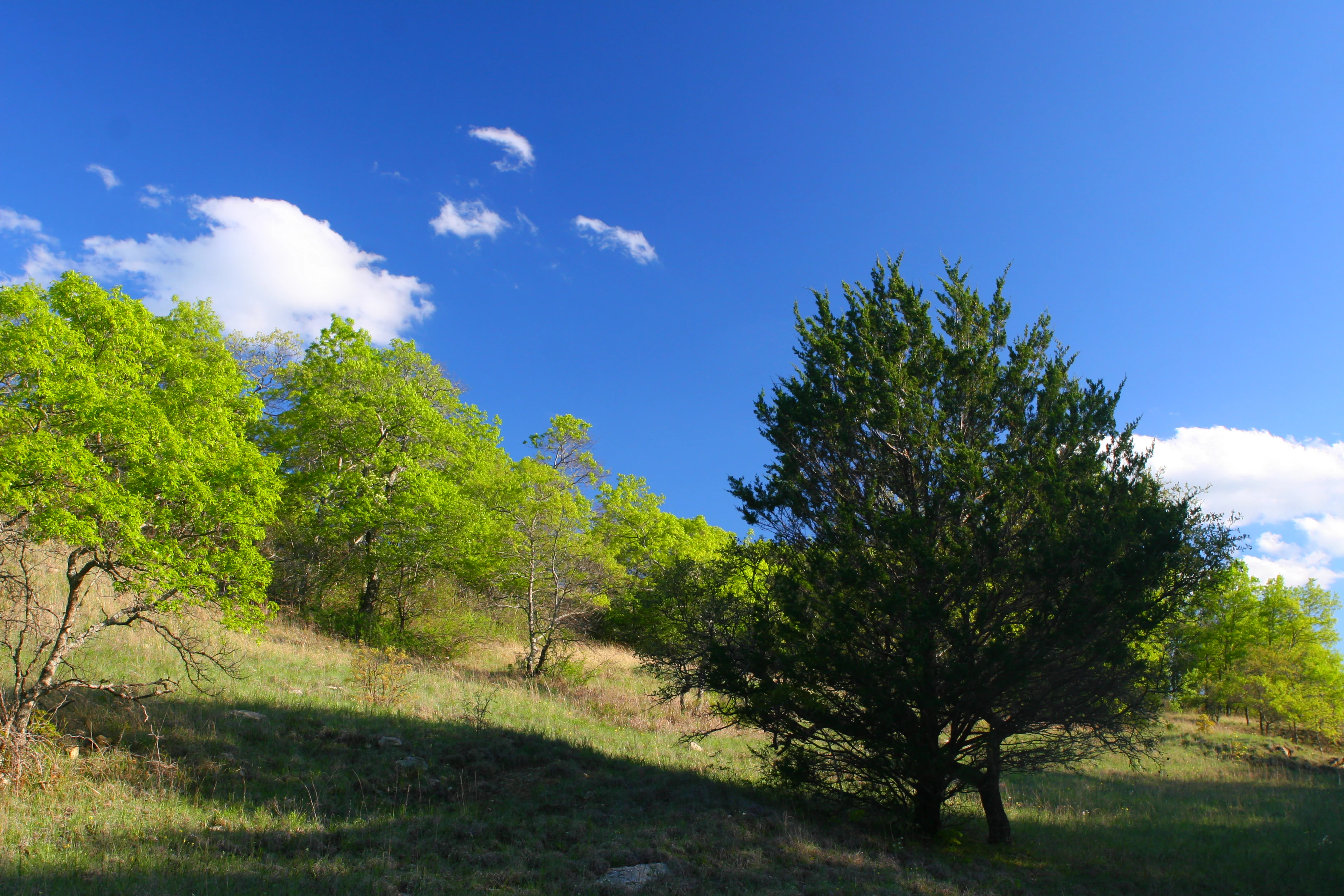
A gentle, sunlit hillside at Lyndon B. Johnson National Grassland with scattered deciduous trees and a prominent evergreen cedar, set against a deep blue sky with sparse white clouds.
A grassy hillside at Lyndon B. Johnson National Grassland.

Lyndon B. Johnson National Grassland history and protected-area timeline

Lyndon B. Johnson National Grassland takes its name from the thirty-sixth president of the United States, Lyndon B. Johnson, whose roots in the Texas Hill Country and north-central Texas gave him deep ties to the state. The unit was established as part of the broader system of national grasslands created to address soil conservation, rangeland health, and the restoration of degraded farmland across the Great Plains during a period when many former croplands were being returned to grass.

Since its establishment, the grassland has been administered by the U.S. Forest Service, which manages it together with other Texas national forests and grasslands. The administrative approach has consistently emphasized multiple use, keeping livestock grazing as an active part of land management while still preserving public access and recreation. Local Forest Service ranger district offices have historically been based in Decatur, the nearest town to the grassland, even though some regional management functions are shared with units several hours to the east.

Over time, the grassland has grown in importance as surrounding private lands have been fragmented by development, agriculture, and rural land change. As one of the larger contiguous blocks of public rangeland in north Texas, LBJ National Grassland has come to represent both a conservation foothold for Great Plains ecosystems in the region and a tangible link to the ranching heritage of the area.

Lyndon B. Johnson National Grassland landscape and geographic character

The landscape of Lyndon B. Johnson National Grassland reflects the transitional character of north-central Texas, where Great Plains prairie gives way to the oak savanna and woodland mosaic of the Cross Timbers. The terrain is gently rolling rather than dramatic, with broad grassy uplands cut by shallow drainages, brushy slopes, and occasional stands of hardwood trees. Creeks and small reservoirs dot the unit, adding riparian corridors and water-based scenery to an otherwise primarily grassland view.

The vegetation pattern is mixed, owing to the grassland's location at the meeting point of true prairie to the west and more wooded country to the east. Open grassland areas are interspersed with patches of oak, pecan, and other hardwoods, alongside brushy thickets that contribute to habitat diversity. Where the land dips toward streams and ponds, the scenery becomes noticeably greener and more sheltered, contrasting with the wide, sun-exposed rangeland that dominates the higher ground.

Lyndon B. Johnson National Grassland ecosystems, habitats, and plant life

Ecologically, Lyndon B. Johnson National Grassland represents a transitional zone between the true grasslands of the Great Plains and the wooded Cross Timbers region of eastern Texas. This combination produces a habitat mosaic rather than a single uniform ecosystem, with prairie grasses, oak woodland, riparian vegetation, and brushy edge habitat all present across the unit. The result is a landscape with relatively high habitat diversity for an area of its size in north Texas.

Because grazing is an established part of land management, the grassland reflects a working rangeland condition in which native grass cover is encouraged, invasive brush is managed, and water sources are maintained for both wildlife and livestock. Wet areas along creeks, stock ponds, and reservoirs also support wetland and aquatic plant communities, contributing additional botanical variety within the broader grassland matrix.

Lyndon B. Johnson National Grassland wildlife and species highlights

The mixed prairie-and-woodland character of LBJ National Grassland supports a broad range of wildlife typical of north-central Texas. White-tailed deer are among the most visible large mammals, and the grassland is recognized as an important deer-hunting area within the state. Other commonly associated mammals include coyotes, bobcats, foxes, raccoons, opossums, armadillos, and various smaller rodents and rabbits that thrive in brushy edge habitat.

Birdlife is a notable feature of the grassland, with species drawn from both eastern woodland and Great Plains open-country communities. Wild turkey, northern bobwhite, and various songbirds are associated with the brushy and wooded portions, while raptors such as hawks patrol the open rangeland. Reptiles common to north Texas, including various snakes and lizards, also use the combination of sun-warmed grassland and rocky or woody cover that the unit provides.

Hunting and fishing are listed among the principal recreational uses of the area, reflecting both the abundance of game species and the presence of water bodies suitable for fishing. The grassland's role as both wildlife habitat and public hunting ground is part of how it functions as a working conservation landscape in the region.

Lyndon B. Johnson National Grassland conservation status and protection priorities

As one of the larger blocks of contiguous public rangeland in north Texas, Lyndon B. Johnson National Grassland plays an outsized conservation role in a region where native prairie has been heavily reduced by agriculture, development, and brush encroachment. Protecting the unit under U.S. Forest Service management helps preserve grassland soils, native plant cover, and habitat connectivity that would otherwise be lost to fragmentation on private land.

The grassland's conservation value comes not only from preservation but from active management. Multiple-use stewardship allows grazing to continue as a tool to maintain grass health, while recreation, hunting, and habitat projects support broader ecological objectives. The mix of open prairie, oak woodland, riparian corridors, and aquatic habitat gives the unit unusually strong habitat diversity for a Great Plains grassland, making it meaningful for grassland-associated species as well as woodland-edge wildlife.

Within the Texas network of national forests and grasslands, LBJ National Grassland is managed alongside the Angelina, Davy Crockett, Sabine, and Sam Houston National Forests and the neighboring Caddo National Grassland. Sharing administration across these units helps integrate conservation planning, fire management, and habitat restoration across a much larger landscape than any single unit could protect on its own.

Lyndon B. Johnson National Grassland cultural meaning and human context

Lyndon B. Johnson National Grassland carries strong regional and political identity because it is named after a U.S. president who came from the Texas Hill Country and helped shape the modern image of Texas politics and public life. The naming reflects the close associations between place, personality, and heritage in Texas, particularly in the parts of the state where Johnson lived and worked before moving into national politics.

Culturally, the grassland is also a continuation of the ranching traditions of north-central Texas. Long before its designation as a national grassland, much of this region was used for cattle ranching and small-scale agriculture, and grazing cattle and other livestock remains a defining activity on the land. The grassland therefore functions as a place where visitors encounter not just prairie scenery but the working agricultural culture that historically defined the region.

Top sights and standout views in Lyndon B. Johnson National Grassland

The strongest points of distinction for Lyndon B. Johnson National Grassland include its size as a significant Great Plains grassland in north Texas, its location within an hour of the Fort Worth metropolitan area, and its blend of preserved prairie with active ranching. The Cross Timbers influence gives the land more tree cover and habitat variety than a strictly western Great Plains site, and the mix of recreation, hunting, fishing, and grazing distinguishes it from strictly wilderness-focused national parks.

Equally notable are the grassland's administrative role within the Texas forest and grassland network and the cultural weight of its presidential name. Together, these elements make LBJ National Grassland both a practical outdoor destination for north Texas residents and a recognizable symbol of Great Plains heritage in the state.

Best time to visit Lyndon B. Johnson National Grassland

Lyndon B. Johnson National Grassland can be visited year-round, but the experience shifts with the seasons in ways that reflect its Great Plains character. Spring brings green-up across the rangeland, mild temperatures, and active wildflower and grassland growth, making it a comfortable period for hiking, horseback riding, and wildlife observation. Fall typically offers cooler weather, attractive grass and foliage color, and good conditions for hunting and camping.

Summer in north Texas is hot, with strong sun and limited shade across open rangeland, so visits during this period tend to concentrate around water bodies, shaded creek bottoms, and early-morning or evening activity. Winter is generally the quietest season, with cooler weather and reduced insect pressure, though periodic cold snaps and variability in conditions can affect overall comfort for outdoor activities.
Monthly climate preview

Trace long-term temperature ranges and precipitation cycles across the representative coordinate.

Lyndon B. Johnson National Grassland Climate Normals and Monthly Weather Data

Lyndon B. Johnson National Grassland displays measured monthly temperature shifts from winter minimums to summer maximums alongside varying precipitation levels. Reviewing the complete twelve-month climate record provides deeper analytical context for long-term regional weather patterns.
Annual mean18 °C
5 °C30 °C
Jan
Feb
Mar13°
Apr18°
May23°
Jun27°
Jul30°
Aug30°
Sep25°
Oct18°
Nov11°
Dec
Warmest month
July

30.1 °C

Coolest month
January

5.2 °C

Wettest month
May

3.8 mm/day

Driest month
January

1.5 mm/day

Park location guide

Geography guide, regional context, and park location map for Lyndon B. Johnson National Grassland

Lyndon B. Johnson National Grassland park geography, regions, and map view in United States of America

Understand where Lyndon B. Johnson National Grassland sits in United States of America through a broader geographic reading of the surrounding landscape, nearby location context, and its mapped position within the national park landscape.

How Lyndon B. Johnson National Grassland fits into United States of America

The United States of America is a federal presidential republic and one of the world's largest countries by area and population. It consists of 50 states across a vast territory spanning multiple time zones, with its capital in Washington, D.C. and largest city in New York City. The nation has a diverse economy, influential political system, and significant cultural and military presence globally.

Wider geography shaping Lyndon B. Johnson National Grassland in United States of America

The United States occupies a vast territory in North America, bordered by Canada to the north and Mexico to the south. The 48 contiguous states stretch from the Atlantic to the Pacific Ocean, while Alaska occupies the northwestern region and Hawaii is an archipelago in the Pacific. The country encompasses diverse terrain including the Rocky Mountains, Appalachian Mountains, Great Plains, and extensive river systems.

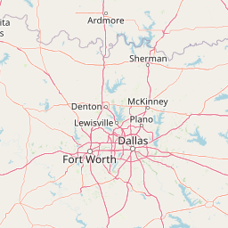
Map view of Lyndon B. Johnson National Grassland

Use this park location map to pinpoint Lyndon B. Johnson National Grassland in United States of America, understand its exact geographic position, and read its mapped placement within the surrounding landscape more clearly.

Pigeon | © OpenStreetMap contributors

Location context for Lyndon B. Johnson National Grassland

Montague CountyTexasWise County
Recorded earthquake history

View Historical Earthquake Records for Lyndon B. Johnson National Grassland

Explore a comprehensive historical catalogue of seismic events recorded in the vicinity of Lyndon B. Johnson National Grassland. This MoriAtlas resource maps documented earthquake activity against the grassland location to provide a clear view of regional seismic history through factual data and event details.

Lyndon B. Johnson National Grassland Earthquake Records

Catalogued events

12 events

Strongest magnitude

Magnitude 3.7

Most recent event

Dec 17, 2015

This history includes earthquakes recorded inside the park or within 50 km of its borders

Visualizing the prairie terrain, oak savannas, and protected habitats of the northern Texas plains

Lyndon B. Johnson National Grassland Photos and Scenery

Examine curated photographs documenting the open grasslands, shallow drainages, and mixed woodland environments of Lyndon B. Johnson National Grassland. Visual documentation clarifies how regional prairie terrain and working pastoral landscapes intersect across the protected public expanse.

A gentle, sunlit hillside at Lyndon B. Johnson National Grassland with scattered deciduous trees and a prominent evergreen cedar, set against a deep blue sky with sparse white clouds.

Park atlas

Compare adjacent prairie reserves, woodlands, and public lands across the surrounding region.

Explore Parks Near Lyndon B. Johnson National Grassland and Regional Protected Areas

Browsing other protected areas near Lyndon B. Johnson National Grassland reveals broader regional terrain patterns and connected public lands. Comparing similar prairie units helps map the ecological diversity of the north Texas landscape.
Watercolor painting of a flowing river with a small waterfall and forested banks against a soft, hilly background.
National parkOklahoma
About 130 km away#1 closest

Northeast

Chickasaw National Recreation Area: Geography and Protected Land Map Overview

Explore spring-fed creek corridors and reservoir landscapes in Oklahoma.

Understand the dual landscape of Chickasaw National Recreation Area, where narrow, spring-fed creek valleys contrast with the expansive shoreline of Lake of the Arbuckles. This record highlights the park's distinct transition from historic CCC-designed infrastructure to the surrounding prairie and forested hill terrain in Murray County.

Area
40.06 km²
Established
1902
Visitors
1.5M annual
Relief
Upland
Protected areaTexas
130 km away#2 closest

East

Caddo National Grassland: Geographic Overview of a Texas Protected Area

Restored prairie and oak savanna in Fannin County

Located in northeastern Texas, Caddo National Grassland encompasses roughly 17,873 acres across two distinct units. The park illustrates a successful shift from eroded agricultural land to a protected mosaic of native grasses, hardwood stands, and aquatic corridors anchored by Lake Davy Crockett, providing a clear window into the recovery of the southern Great Plains.

Area
72.33 km²
Established
1930
Relief
Lowland
Climate
Temperate
Watercolor painting of a forested landscape with soft rolling mountains in the background and vegetation in the foreground.
Protected landscapeArkansas
251 km away#3 closest

Northeast

Ouachita National Forest: Protected Landscape and Mountain Geography in Arkansas

Exploring the ancient ridges and river corridors of the Ouachita Mountains

Ouachita National Forest protects a unique geological system of east-west folded ridges and sandstone bluffs in the interior United States. This expansive region provides vital habitats for diverse hardwood communities and hosts extensive wilderness areas, offering a deep look into the natural history and terrain of the Ouachita Mountain range within Arkansas.

Area
7,221.44 km²
Established
1907
IUCN
VI
Relief
Mountain
Protected areaOklahoma
About 292 km away#4 closest

Northeast

Winding Stair Mountain National Recreation Area: Oklahoma Protected Mountain Landscape

Mapped ridge systems and forested highland geography.

Spanning the prominent Winding Stair Mountains, this protected area serves as a key geographic pillar in southeastern Oklahoma. The landscape is characterized by its high-elevation ridgeline profile, pine-covered slopes, and stream-fed valleys, offering a distinct look at the wider Ouachita National Forest ecosystem and its mountainous terrain.

Area
107.02 km²
Established
1988
Relief
Mountain
Climate
Temperate
A horizontal watercolor painting depicting a soft-toned, misty prairie landscape with rolling green hills, patches of tall grass, and distant hazy ridgelines under a pale sky.
Wildlife reserveUnited States of America
293 km away#5 closest

Northwest

Black Kettle National Grassland: Protected Prairie Geography and Regional Map Context

A restored mixed-grass ecosystem in the southern Great Plains

Spanning scattered parcels in Oklahoma and Texas, Black Kettle National Grassland functions as a representative sample of restored southern plains prairie. The terrain consists of sandy soils, rocky red hills, and leafy draws along the Washita River headwaters. This protected area preserves a complex ecological and historical landscape that defines the character of the southern Great Plains, now managed for habitat restoration and natural resource protection.

Area
126.61 km²
Established
1960
Relief
Upland
Climate
Temperate
A pale, minimalist watercolor painting showing a soft green treeline and forest edge against a white background.
Protected landscapeTexas
343 km away#6 closest

Southeast

Sam Houston National Forest: Mapping the Piney Woods Protected Landscape

Regional Geography of East Texas Protected Lands

Sam Houston National Forest is a 163,000-acre protected area in East Texas characterized by loblolly and shortleaf pine ridges. The geography features an intricate network of creeks, hardwood bottomlands, and designated wilderness areas like Little Lake Creek. Framed by Lake Conroe and Lake Livingston, the forest offers a complex look at Gulf Coastal Plains topography and long-standing Piney Woods ecological restoration efforts.

Area
659.82 km²
Established
1936
Relief
Lowland
Climate
Subtropical
Protected landscapeTexas
345 km away#7 closest

Northwest

McClellan Creek National Grassland: Protected Landscape and Texas Geography Atlas

Restored shortgrass prairie and riparian reservoir geography

Located in the Texas Panhandle, McClellan Creek National Grassland serves as a critical example of soil conservation and shortgrass prairie restoration. The protected area features open, rolling plains surrounding the impounded McClellan Lake, providing a focused look at the environmental history and geographic character of the southern Great Plains.

Area
5.86 km²
Water
Minor water
Protected landscapeArkansas
About 347 km away#8 closest

Northeast

Ozark, St. Francis National Forest: Geographic Overview of Arkansas Protected Wilderness Areas

Mapping rugged mountain slopes and Mississippi River floodplains.

This geographic profile of Ozark, St. Francis National Forest details the distinct ecological divide between the northern Ozark Mountain units and the eastern St. Francis ridge landscape. Use this data to trace the boundaries of old-growth pine stands, karst topography, and river-bottom habitats within one of Arkansas's most significant federal forest management systems.

Area
4,693.55 km²
Established
1908
Relief
Mountain
Climate
Temperate

Common questions about visiting, size, designation, and location context for Lyndon B. Johnson National Grassland

Lyndon B. Johnson National Grassland FAQs for park facts, access, geography, and protected area context

Find quick answers about Lyndon B. Johnson National Grassland, including protected-area facts, park geography, trail and visitor context, and how the park fits into its surrounding country and regional landscape.
MoriAtlas Explorer

Continue Your Protected Areas Search Across the Global Atlas

Deepen your exploration by continuing the structured search for national parks and protected areas worldwide. Utilize the comprehensive filtering capabilities to compare different conservation landscapes and refine your understanding of global park geography. Discover more about the distribution and characteristics of protected natural areas.

Global natural geography