Mori Atlas logo
Nature reserveMac Clark (Acacia peuce) Conservation Reserve

Mapped boundaries and arid-zone geography of an ancient waddywood woodland sanctuary.

Mac Clark (Acacia peuce) Conservation Reserve: A Protected Landscape in Northern Territory

The Mac Clark (Acacia peuce) Conservation Reserve stands as a vital protected area on the edge of the Simpson Desert in the Northern Territory. Spanning a flat, stony plain, this reserve acts as a critical refuge for the rare Acacia peuce, a slow-growing waddywood tree species that thrives in one of the harshest environments on the Australian continent. Its boundaries enclose a unique arid ecosystem that supports rare botanical heritage and historic cultural sites.

arid-zone conservationrare tree reserveAcacia peucewaddywoodSimpson Desert edgeNorthern Territory

Mac Clark (Acacia peuce) Conservation Reserve

Nature reserve

Park overview

Structured park overview, official facts, and landscape profile for Mac Clark (Acacia peuce) Conservation Reserve

Mac Clark (Acacia peuce) Conservation Reserve park facts, protected area profile, and essential visitor context

Review the core facts for Mac Clark (Acacia peuce) Conservation Reserve, including designation, size, terrain, visitor scale, habitats, and operating context in one park-focused overview.

About Mac Clark (Acacia peuce) Conservation Reserve

Mac Clark (Acacia peuce) Conservation Reserve is a specialised arid-land reserve in central Australia, set in a part of the Northern Territory where the land flattens into stony desert pavement on the approach to the Simpson Desert. Its defining feature is ecological rather than scenic: it exists principally to safeguard an important population of Acacia peuce, a tree species that has largely disappeared from the surrounding region and is now represented in only a few isolated stands across the inland.

Geographically, the reserve sits within a vast working pastoral landscape. It is enclosed entirely by Andado Station, an active cattle property whose name is drawn from an Arrente word relating to stone tools, a linguistic reminder that the area carries deep Aboriginal history as well as European pastoral history. The fenced boundary of the reserve separates the protected waddywood stand and associated vegetation from grazing pressure, an essential distinction in a region where introduced herbivores such as cattle and rabbits can quickly destroy seedlings.

The reserve's importance is amplified by its climatic context. The area experiences extremely hot summers, cool winters, and limited, irregular rainfall, conditions that restrict most plant growth and make the persistence of mature Acacia peuce trees remarkable. Research within the reserve focuses on regeneration and growth rates, recognising that the future of the species depends on the survival of seedlings in this demanding environment. Away from the trees themselves, the surrounding stony plains and sparse shrub cover form a textbook example of arid-zone Australian ecology.

For visitors and researchers, Mac Clark is not a destination of dramatic scenery but of focused natural history interest. Access is via remote outback tracks, reflecting its location deep in the Australian interior and reinforcing the sense that the reserve is a quiet, purposeful refuge. Its combination of botanical rarity, harsh desert setting, cultural depth, and small but carefully managed footprint gives it an outsized role in the conservation of Australia's arid-zone flora.

Quick facts and research context for Mac Clark (Acacia peuce) Conservation Reserve

Mac Clark (Acacia peuce) Conservation Reserve is a small protected area in the Ghan locality of the Northern Territory, situated roughly 130 kilometers south of the Ltyentye Apurte Community and about 290 kilometers southeast of Alice Springs. It lies on the western margin of the Simpson Desert and is fully surrounded by the Andado pastoral lease, an operating cattle station that gives the broader landscape its name.

The reserve was established in 1982 and is managed by the Parks and Wildlife Commission of the Northern Territory. Although the area itself is small, it is recognised for protecting stands of Acacia peuce, a tree species that elsewhere in Australia had been reduced to just a handful of fragmented populations. The reserve has been listed on the Northern Territory Heritage Register, underscoring its combined natural and cultural value.

Protection and recognition

Documented terrestrial protection scope, management framework, and official designation records

Mac Clark (Acacia peuce) Conservation Reserve Protection Status and Designation History

Mac Clark (Acacia peuce) Conservation Reserve maintains a documented terrestrial protection status established in 1994 without international recognition designations or transboundary status. Structured conservation records provide official administrative background for this protected landscape and its management history.

Protection details

Protection scope
Terrestrial
Designated year
1994
Transboundary protection
No
Park context

Deeper park guide and search-rich context for Mac Clark (Acacia peuce) Conservation Reserve

Mac Clark (Acacia peuce) Conservation Reserve history, landscape, wildlife, and travel context

Explore Mac Clark (Acacia peuce) Conservation Reserve through its history, landscape character, ecosystems, wildlife, conservation priorities, cultural context, and seasonal travel timing in a structured park guide built for atlas discovery and search intent.

Why Mac Clark (Acacia peuce) Conservation Reserve stands out

The reserve is best known for protecting one of the last significant populations of Acacia peuce, a long-lived and exceptionally rare wattle species of the arid interior. Within an environment where few woody plants can establish, these trees grow slowly and can reach substantial size, developing the broad, spreading crowns that make an isolated stand of mature waddywood trees appear otherworldly against the flat desert plain. Conservation attention centres on the species' remarkable biology and its vulnerability. Acacia peuce can live for several centuries and is threatened by drought, fire, rabbits, and livestock pressure on seedlings, making fenced refuges such as Mac Clark essential to its survival. The reserve is therefore as much a living botanical archive as it is a habitat reserve, preserving genetic stock of a tree that once formed a wider presence across inland Australia.
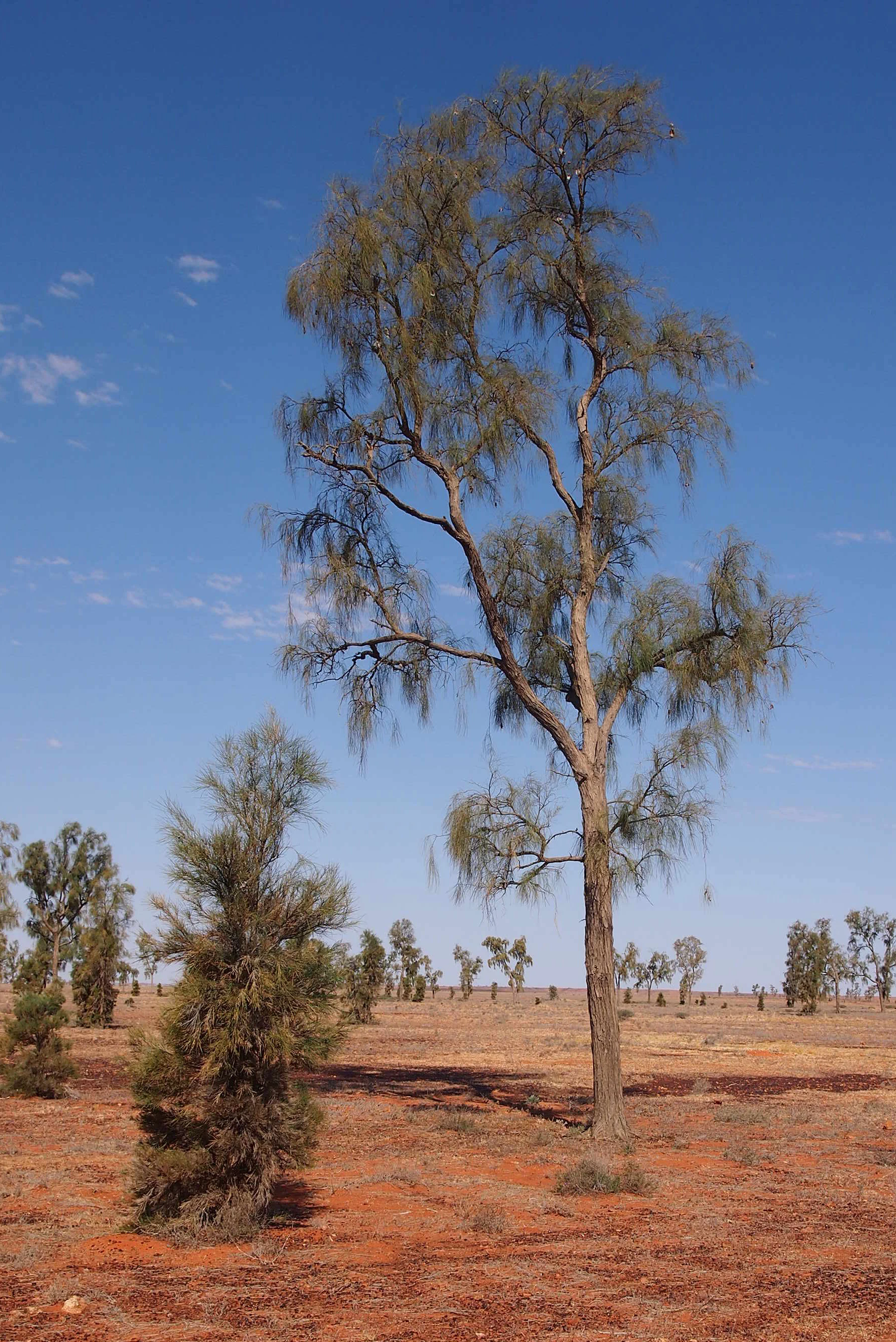
A tall, slender mature Acacia peuce tree stands in an arid, open landscape with red soil and scattered low vegetation under a clear blue sky.
A mature Acacia peuce tree, also known as Waddy-wood, in the arid landscape of the Mac Clark Conservation Reserve.

Mac Clark (Acacia peuce) Conservation Reserve history and protected-area timeline

The history of Mac Clark (Acacia peuce) Conservation Reserve is tightly intertwined with the broader story of pastoral settlement in central Australia and with the efforts of one family to protect a rare tree species from disappearing locally.

Aboriginal people, who are the traditional owners of the area, have lived in and moved through this landscape for thousands of years. The cultural heritage of the Arrente peoples is woven into the land itself, reflected in artefacts still found across the region and in place names such as Andado, which comes from an Arrente word referring to stone tools.

European arrival began in the 1880s, when settlers moved into the district to take up pastoral country, initially running sheep and later concentrating more on cattle. The Andado pastoral lease, which now surrounds the reserve, became part of this wider network of outback stations. In 1955, Malcolm "Mac" Clark and his wife Molly took up residence at Andado Station, where Mac lived until his death from a heart attack in 1978. It was Mac Clark's strong personal interest in conserving the unusual waddywood trees on the property that inspired the eventual establishment of the reserve that now bears his name.

During the early twentieth century, most of the Acacia peuce trees in the surrounding region had been felled to provide timber for station buildings, shelters, and stockyards. By the time conservation efforts began, only three populations of the species were known to survive: at Andado, near Birdsville in Queensland, and near Boulia, also in Queensland. Recognising the precarious state of the Andado stand, the Northern Territory government formally established the conservation reserve in 1982, creating a fenced refuge dedicated to the protection and study of these trees.

Since then, the reserve has gained formal heritage recognition. It was listed on the now-defunct Register of the National Estate in 1991, and was added to the Northern Territory Heritage Register on 14 September 1994, acknowledging its combined natural and cultural significance within the Territory.

Mac Clark (Acacia peuce) Conservation Reserve landscape and geographic character

The landscape of Mac Clark Conservation Reserve is defined by its starkness and openness. It lies on a flat, stony, windswept plain in one of the hottest parts of Australia, grading into the western edge of the Simpson Desert. The terrain is essentially an arid pavement, with thin, stony soils supporting only a sparse cover of low shrubs and grasses. There are no prominent ranges, dramatic cliffs, or water features within the reserve itself; instead, the visual character is one of vast horizontal distance, pale ground, and clear desert skies.

Despite this apparent emptiness, the landscape is ecologically distinctive. The same conditions that limit ordinary vegetation, including extreme heat, low rainfall, persistent winds, and stony ground, are precisely the conditions in which Acacia peuce has evolved to thrive. The result is a striking visual contrast between the bare plain and the dark, spreading crowns of mature waddywood trees, which can reach heights of around 17 meters and stand in isolation across the flats.

Beyond the reserve's boundaries, the surrounding Andado pastoral lease adds context to the landscape, with cattle grazing infrastructure and station tracks reinforcing the working pastoral character of the region. The broader setting, stretching toward the Simpson Desert, gives a strong sense of isolation typical of the central Australian outback, where distance and climatic extremes shape both the land itself and the human history of settlement and travel across it.

Mac Clark (Acacia peuce) Conservation Reserve ecosystems, habitats, and plant life

Ecologically, Mac Clark Conservation Reserve represents a narrow but intense expression of arid-zone Australian nature. The vegetation is dominated by sparse, drought-adapted shrubland and grassland communities typical of stony desert plains, with bare interzones between scattered plants. This kind of environment supports relatively few woody species, and the reserve's botanical significance lies precisely in its capacity to sustain a tree that most other plants of similar size simply cannot maintain.

The Acacia peuce, or waddywood, is the ecological anchor of the reserve. This long-lived wattle has adapted to one of Australia's harshest climates, persisting through droughts, heatwaves, and fires that eliminate less tolerant species. Mature individuals form broad, often characterful canopies and dominate the local visual landscape, while the surrounding plant community forms a simple but resilient matrix of low shrubs and grasses. The combined ecosystem serves as a refuge for species that would otherwise struggle in more heavily grazed parts of the region.

Because the reserve is small, fenced, and historically exposed to pastoral activity, the interaction between protection and regeneration is central to its ecological function. Research at the site focuses on how seedlings survive, how quickly trees grow, and how threats such as rabbits, fire, drought, and livestock pressure shape recruitment into the adult population. The reserve therefore functions as both a refuge and an outdoor laboratory for understanding arid-zone woodland dynamics.

Mac Clark (Acacia peuce) Conservation Reserve wildlife and species highlights

Given the harshness of the setting, Mac Clark Conservation Reserve supports a wildlife community typical of the arid interior of central Australia, characterised by species adapted to extreme heat, scarce water, and sparse vegetation. Small ground-dwelling mammals, reptiles, and a range of arid-adapted birds occupy the stony plains and open shrubland. Wildlife observations in the reserve are tied closely to rainfall patterns, with activity and visibility fluctuating strongly as conditions shift between dry periods and occasional wet pulses.

The reserve's fenced status has an important secondary effect on fauna. By excluding large domestic livestock, and through ongoing management of threats such as rabbits, the reserve creates conditions in which native fauna can utilise habitats and resources that would otherwise be heavily impacted by grazing. This contributes to broader patterns of refuge-based conservation that are common across Australia's arid lands, where small fenced reserves provide critical breathing space for species otherwise exposed to widespread pastoral pressure.

Wildlife within Acacia peuce woodland itself is not abundant, reflecting the relatively open structure of the habitat, but the trees provide shade, perching sites, and occasional food resources for birds and insects, and the wider stony plain supports reptile and small mammal activity. The reserve's wildlife value is best understood as a working element of an arid ecosystem rather than as a showcase of charismatic large fauna.

Mac Clark (Acacia peuce) Conservation Reserve conservation status and protection priorities

The conservation significance of Mac Clark (Acacia peuce) Conservation Reserve is exceptional relative to its size. The reserve was established explicitly to protect one of the last significant stands of Acacia peuce in Australia, a species that had been reduced largely through historical clearing for pastoral infrastructure. With only a few populations surviving nationally, the reserve plays a disproportionate role in safeguarding the genetic legacy of the species.

Protection is achieved principally through fencing and active management rather than through remoteness alone. The fence excludes cattle and helps control pressure from rabbits, both of which are recognised threats to seedling survival. In an environment where most trees produce relatively few seedlings that survive to maturity, the inclusive fence is the critical factor distinguishing the reserve from surrounding grazing land. This kind of targeted intervention is typical of arid-zone conservation in Australia, where small exclusion areas can anchor regional survival of vulnerable plants.

Beyond protecting trees, the reserve supports active research into regeneration and growth rates of Acacia peuce, helping to build scientific understanding of how the species responds to drought, fire, and herbivore pressure. Its listing on heritage registers reflects recognition that the site is valuable not only for its flora but also for its cultural landscape and pastoral history. Together, these factors make the reserve a high-value conservation asset well beyond what its modest area alone might suggest.

Mac Clark (Acacia peuce) Conservation Reserve cultural meaning and human context

The cultural context of Mac Clark Conservation Reserve spans thousands of years of Aboriginal land use and over a century of European pastoral activity, both of which are still legible in the present-day landscape. The area lies within the traditional country of the Arrente peoples, who travelled through and used these lands for millennia. Artefacts and sites across the reserve and surrounding Andado lease attest to that long history, while the name Andado itself derives from an Arrente word meaning stone tool, a linguistic trace of the deep Aboriginal presence in the region.

European pastoralism began in the 1880s, initially focused on sheep and later on cattle. The reserve grew out of this pastoral landscape. The personal conservation ethos of Malcolm "Mac" Clark, a long-time manager of Andado Station, gave the reserve its name and continues to shape how its history is understood. This blend of Aboriginal heritage and twentieth-century pastoral stewardship is an important part of how the reserve is recognised, and is reflected in its inclusion on the Northern Territory Heritage Register.

Today, the reserve sits within a working cattle station, harmonising conservation goals with continuing pastoral land use. Access requires travel through country that remains culturally significant to traditional owners, most notably through the Ltyentye Apurte Community, an important Arrente centre to the north. Visitors to the reserve effectively move through both a botanical sanctuary and a layered cultural landscape.

Top sights and standout views in Mac Clark (Acacia peuce) Conservation Reserve

Standing in a flat, stony plain on the edge of the Simpson Desert, Mac Clark (Acacia peuce) Conservation Reserve protects one of the last mature stands of Acacia peuce, or waddywood, in Australia, a tree that can live for hundreds of years in conditions that defeat most woody plants. Its fenced boundary, established in 1982 and managed by the Parks and Wildlife Commission of the Northern Territory, shields ancient trees and their seedlings from cattle, rabbits, fire, and prolonged drought, while supporting ongoing research into the species' regeneration.

Beyond its botanical importance, the reserve carries strong cultural and historical meaning. It sits within Arrente traditional country, with abundant Aboriginal artefacts in the surrounding landscape, and its name honours the Clark family's long-running pastoral stewardship of Andado Station. Its listing on the Northern Territory Heritage Register reflects this combined natural and cultural significance, making it a small but unusually rich site within Australia's arid-zone conservation network.

Best time to visit Mac Clark (Acacia peuce) Conservation Reserve

The climate at Mac Clark is extreme, with hot summers that frequently exceed 40 degrees Celsius and very low annual rainfall, so the cooler months between late autumn and early spring offer far more comfortable conditions for travel through the surrounding outback. Winter and early spring typically bring milder daytime temperatures, clearer skies, and a lower risk of the heat-related hazards that make summer travel in central Australia challenging.

Seasonal conditions also influence what the reserve looks like and how it feels ecologically. After occasional rains, the stony plains respond with brief flushes of green growth and heightened wildlife activity, while drier periods emphasise the stark, windswept character of the landscape. Cooler months are generally more suitable for appreciating mature Acacia peuce trees, walking the reserve's open terrain, and travelling the remote access tracks from the Stuart Highway, Ltyentye Apurte Community, or Kulgera without the punishing heat of midsummer.

Monthly climate preview

Long term monthly temperature and precipitation averages across the protected reserve coordinate

Mac Clark (Acacia peuce) Conservation Reserve Climate Normals And Annual Temperature Rhythm

Representative coordinate records show sustained thermal variations and minimal monthly precipitation totals across the protected landscape. Full monthly climatology datasets provide granular insight into long term temperature bounds and precipitation averages.
Annual mean23 °C
13 °C33 °C
Jan33°
Feb31°
Mar28°
Apr23°
May18°
Jun14°
Jul13°
Aug16°
Sep21°
Oct25°
Nov29°
Dec31°
Warmest month
January

32.5 °C

Coolest month
July

13.4 °C

Wettest month
February

1.1 mm/day

Driest month
August

0.1 mm/day

Park location guide

Geography guide, regional context, and park location map for Mac Clark (Acacia peuce) Conservation Reserve

Mac Clark (Acacia peuce) Conservation Reserve park geography, regions, and map view in Australia

Understand where Mac Clark (Acacia peuce) Conservation Reserve sits in Australia through a broader geographic reading of the surrounding landscape, nearby location context, and its mapped position within the national park landscape.

How Mac Clark (Acacia peuce) Conservation Reserve fits into Australia

Australia is a constitutional monarchy and federal parliamentary democracy comprising six states and ten territories. With a population of nearly 28 million, it is one of the world's most urbanised countries, with most people concentrated on the eastern seaboard. The country has a high Human Development Index and is known for its cultural diversity, ancient Aboriginal heritage, and unique wildlife.

Wider geography shaping Mac Clark (Acacia peuce) Conservation Reserve in Australia

Australia occupies the entire Australian continent, the island of Tasmania, and numerous smaller islands. It is the world's flattest and driest inhabited continent, featuring vast deserts in the interior (the Outback), tropical rainforests along the eastern coast, and a coastline bordering the Indian and Pacific Oceans.

Map view of Mac Clark (Acacia peuce) Conservation Reserve

Use this park location map to pinpoint Mac Clark (Acacia peuce) Conservation Reserve in Australia, understand its exact geographic position, and read its mapped placement within the surrounding landscape more clearly.

Pigeon | © OpenStreetMap contributors

Location context for Mac Clark (Acacia peuce) Conservation Reserve

Northern Territory

Visual exploration of rare waddywood trees, stony desert plains, and outback habitats.

Mac Clark (Acacia peuce) Conservation Reserve Photos and Arid Landscape Scenery

Visual documentation reveals the stark terrain, flat stony pavements, and isolated stands of ancient waddywood trees defining the reserve. Examining protected-area photography provides clear insight into arid-zone ecology, botanical rarity, and remote outback geography.

A tall, slender mature Acacia peuce tree stands in an arid, open landscape with red soil and scattered low vegetation under a clear blue sky.

Park atlas

Compare adjacent arid reserves and regional outback landscapes across central Australia.

Parks Near Mac Clark (Acacia peuce) Conservation Reserve and Surrounding Protected Areas

Browsing other protected areas near Mac Clark (Acacia peuce) Conservation Reserve reveals broader ecological patterns across arid outback plains. Comparing adjacent desert reserves provides valuable geographic context for understanding rare plant habitats and remote regional terrain.
National parkSouth Australia
About 97 km away#1 closest

South

Witjira National Park: Explore its Protected Landscape and South Australian Geography

Mapped terrain and regional park context.

Witjira National Park in South Australia serves as a distinct protected area for detailed geographic exploration. This national park provides essential context for understanding its mapped boundaries and its role within the broader regional landscape of Australia. Discover the park's specific geographic identity and its significance as a protected natural area for atlas-based research and landscape appreciation.

Area
7,726.73 km²
Established
1985
IUCN
VI
Visitors
15K annual
National parkSouth Australia
About 118 km away#2 closest

Southeast

Munga-Thirri, Simpson Desert National Park: Explore South Australia's Vast National Park Territory

Mapped boundaries and arid landscape context.

Munga-Thirri, Simpson Desert National Park is a crucial national park located in South Australia, offering a detailed look into the mapped geography and protected landscape characteristics of Australia's arid interior. This page facilitates an atlas-driven understanding of the park's protected boundaries, regional context, and unique desert terrain. Explore the fundamental geographic identity of this significant protected area, providing essential data for landscape discovery.

Area
36,000 km²
Established
1967
IUCN
Ia
Relief
Lowland
A soft watercolor painting of a desert landscape featuring rolling plains and a prominent, pillar-like rock formation on the horizon under a pale sky.
Natural monumentNorthern Territory
About 173 km away#3 closest

West

Chambers Pillar Historical Reserve: An Atlas of a Significant Northern Territory Sandstone Landmark

Geographic analysis of an iconic Australian outback desert monument

Chambers Pillar is a striking 50-meter sandstone column anchored in the arid plains of central Australia. This historical reserve serves as an essential subject for geological and regional mapping, offering a clear look at how isolated formations define the vast outback horizon. Explore the intersection of 350-million-year-old rock formations and the shifting desert sands that shape this protected cultural and natural site.

Area
3.4 km²
Relief
Lowland
Climate
Arid
Access
Remote access
A wide, panoramic watercolor painting showing a soft landscape with rolling hills in the background, green trees and bushes in the midground, and a pinkish path or river in the foreground.
Protected areaNorthern Territory
About 188 km away#4 closest

North

Ruby Gap Nature Park: Geography and Protected Wilderness in the Northern Territory

Gorge-carved arid landscapes and historical mining heritage

Ruby Gap Nature Park stands as a remote protected area in the heart of Australia's Northern Territory. Defined by the Hale River gorge, the terrain showcases dramatic cliff lines, expansive rocky flats, and rich geological sites that reveal a layered story of Indigenous heritage and 19th-century boom-and-bust mining history. Explore the park boundary and the surrounding East MacDonnell Ranges through this focused geographic overview.

Area
92.57 km²
Relief
Upland
Climate
Arid
Access
Remote access
A wide watercolor illustration showing a winding river or creek bed flanked by green trees, with pink and red rocky hills in the background under a pale sky.
Nature reserveNorthern Territory
About 196 km away#5 closest

Northwest

N'Dhala Gorge Nature Park: Mapped Geography and Protected Cultural Heritage

Nature reserve located in the eastern MacDonnell Ranges

This nature reserve protects a vital valley corridor in the Northern Territory where sandstone ridges and sandy terrain meet. The park serves as a repository for approximately 6,000 ancient petroglyphs and sustains specialized arid plant species. Use this resource to understand the park's structural boundaries and its place within the broader geography of Central Australia.

Area
5.01 km²
Established
1962
IUCN
V
Relief
Mountain
Watercolor painting of a soft, abstract landscape with a line of trees against rolling hills and light, hazy colors.
Nature reserveNorthern Territory
About 200 km away#6 closest

Northwest

Napwerte / Ewaninga Rock Carvings Conservation Reserve: Protected Desert Landscape Map

Cultural heritage and arid basin geography in the Northern Territory

Napwerte / Ewaninga Rock Carvings Conservation Reserve protects a unique desert site defined by its extensive collection of prehistoric Arrernte rock engravings. The landscape encompasses rocky outcrops, red sand dunes, and a seasonal claypan that captures rare rainfall, creating a significant intersection of archaeological history and arid-zone ecology in central Australia.

Area
0.06 km²
Established
1970
IUCN
V
Relief
Lowland
Protected areaNorthern Territory
About 202 km away#7 closest

Northwest

Arltunga Historical Reserve: A Heritage Protected Area in Northern Territory Australia

Mapping nineteenth century mining ruins and arid terrain

Arltunga Historical Reserve offers a distinct window into the outback mining era through its well-preserved stone structures and desolate desert setting. This protected area within the Northern Territory highlights the intersection of European settlement history and the traditional cultural heritage of the Eastern Arrernte people.

Area
50 km²
Established
1975
Relief
Upland
Climate
Arid
Protected landscapeNorthern Territory
About 206 km away#8 closest

Northwest

Corroboree Rock Conservation Reserve: Geological and Cultural Protected Area in Central Australia

Mapped protected landscape within the East MacDonnell Ranges

Corroboree Rock Conservation Reserve features a striking dolomite rock formation tied to ancient Precambrian salt lake sediments. Located east of Alice Springs, the reserve provides a protected glimpse into central Australian arid range geography and holds profound cultural importance for the Eastern Arrernte Traditional Owners within the surrounding pastoral landscape.

Area
0.07 km²
Established
1962
IUCN
V
Visitors
15K annual

Common questions about visiting, size, designation, and location context for Mac Clark (Acacia peuce) Conservation Reserve

Mac Clark (Acacia peuce) Conservation Reserve FAQs for park facts, access, geography, and protected area context

Find quick answers about Mac Clark (Acacia peuce) Conservation Reserve, including protected-area facts, park geography, trail and visitor context, and how the park fits into its surrounding country and regional landscape.
MoriAtlas Explorer

Continue Your Protected Areas Search Across the Global Atlas

Deepen your exploration by continuing the structured search for national parks and protected areas worldwide. Utilize the comprehensive filtering capabilities to compare different conservation landscapes and refine your understanding of global park geography. Discover more about the distribution and characteristics of protected natural areas.

Global natural geography