Mori Atlas logo
National parkMachalilla National Park

Discover the mapped boundaries and natural terrain of this key national park in Ecuador.

Machalilla National Park: Protected Landscape and Geographic Atlas in Manabí Province, Ecuador

Machalilla National Park represents a significant protected natural landscape within Ecuador's Manabí Province, offering critical insights into regional geography and conservation areas. This page serves as an atlas-focused gateway to understanding the park's mapped boundaries, its place within the broader terrestrial and coastal context of the region, and its value as a distinct protected entity for geographic discovery. Explore the foundational geographic elements that define this important national park.

National ParkPacific CoastCloud ForestDry ForestRamsar SiteBirdwatching

Machalilla National Park

National park

Park overview

Structured park overview, official facts, and landscape profile for Machalilla National Park

Machalilla National Park park facts, protected area profile, and essential visitor context
Review the core facts for Machalilla National Park, including designation, size, terrain, visitor scale, habitats, and operating context in one park-focused overview.

About Machalilla National Park

Machalilla National Park represents one of Ecuador's most significant coastal protected areas, protecting a transition zone where Pacific coastal ecosystems meet Andean foothills. The park's location along the Manabí coast places it at the crossroads of multiple biogeographic regions, resulting in an unusual concentration of habitats within its boundaries. Visitors encounter fog-shrouded cloud forest canopies, sun-baked tropical dry forest with distinctive deciduous trees, sandy beaches backed by mangrove swamps, and rocky offshore islands that provide critical nesting habitat for seabirds. The park was established in 1979 specifically to protect these diverse ecosystems from the mounting pressures of commercial fishing, deforestation for agriculture and charcoal production, and unregulated tourism development that had begun to impact the region. The establishment reflected growing recognition that Ecuador's coastal dry forests were among the most threatened habitats in South America, with most of the original forest cover already lost to human activity by the late 20th century.

Quick facts and research context for Machalilla National Park

Machalilla National Park is located on Ecuador's Pacific coast in Manabí Province, approximately 150 kilometers southwest of the city of Manta. The park encompasses mainland coastal terrain as well as offshore islands, with Isla de la Plata being the most prominent. The area experiences a semi-arid to subtropical climate with a distinct dry season. The park protects remnants of the tropical dry forest ecosystem that once covered much of coastal Ecuador but now exists in severely fragmented patches. The marine zone includes important breeding grounds for humpback whales and supports fishing communities that have traditional ties to the area.

Park context

Deeper park guide and search-rich context for Machalilla National Park

Machalilla National Park history, landscape, wildlife, and travel context
Explore Machalilla National Park through its history, landscape character, ecosystems, wildlife, conservation priorities, cultural context, and seasonal travel timing in a structured park guide built for atlas discovery and search intent.

Why Machalilla National Park stands out

Machalilla National Park is best known for its remarkable ecological diversity that spans multiple distinct habitats within a relatively compact area, and for being the only known habitat on mainland Ecuador for the waved albatross, a species otherwise found only in the Galápagos Islands. The park's Isla de la Plata is famous for its breeding colonies of seabirds and for the legend of Sir Francis Drake's hidden silver hoard. The coastal waters support seasonal humpback whale migrations, while the dry forest and cloud forest harbor endangered primate species and exceptional bird diversity exceeding 270 documented species. The park also preserves archaeological sites associated with the pre-Columbian Machalilla culture that dates back to around 1800 BCE.

Machalilla National Park history and protected-area timeline

Machalilla National Park was officially established on July 26, 1979, as part of Ecuador's expanding national park system during a period of increased environmental awareness in the country. The creation of the park responded to growing concerns about the degradation of coastal ecosystems and the need to protect remaining patches of tropical dry forest that had been largely eliminated from mainland Ecuador. In 1990, the park received additional recognition when its wetland and marine areas were designated under the Ramsar Convention, establishing it as an internationally important wetland and providing additional framework for protecting the coastal and marine environments. Conservation partnerships developed in the 1990s, notably including the Parks in Peril program funded by The Nature Conservancy and USAID, which supported ranger training, infrastructure development, and community-based conservation initiatives. The park established an on-site environmental education center and began hiring local community members as park guards, creating economic incentives for conservation among neighboring populations.

Machalilla National Park landscape and geographic character

The physical landscape of Machalilla National Park is defined by the transition from the Pacific coastline into the coastal range of the Andean foothills. The mainland portion features a combination of flat coastal plains, rolling hills covered in dry forest, and isolated peaks that support cloud forest formations where moisture from the ocean condenses in the canopy. Beaches along the Pacific vary from wide sandy stretches to rocky coves, with offshore reefs and rocky islets providing additional habitat diversity. Two larger islands, Salango and Isla de la Plata, rise from the ocean as rocky volcanic formations with limited vegetation but significant seabird populations. The sulfur lagoon at Aguablanca represents one of the park's distinctive geological features, a shallow alkaline lake that supports specialized aquatic organisms adapted to its mineral-rich waters. The terrain transitions from semi-arid coastal scrub at lower elevations through increasingly dense dry forest into the cloud forest zones that capture moisture from the persistent coastal fog.

Machalilla National Park ecosystems, habitats, and plant life

The ecological character of Machalilla National Park is defined by the juxtaposition of tropical dry forest and cloud forest ecosystems that exist in close proximity along the coastal elevation gradient. The tropical dry forest, once covering perhaps 25 percent of western Ecuador, now survives in only fragmented patches with Machalilla representing one of the largest remaining intact areas. Characteristic tree species include the palo santo, a resinous tree valued for its aromatic wood, the massive kapok or ceiba with its distinctive trunk shape, and various cacti including opuntia species adapted to the prolonged dry season. The cloud forest that develops on higher elevations and in areas where fog provides consistent moisture supports a different community of species including epiphytes, ferns, and moisture-dependent organisms. The marine environment includes productive coastal waters, mangroves, and rocky reef systems that support different assemblages of fish, invertebrates, and marine mammals.

Machalilla National Park wildlife and species highlights

The wildlife of Machalilla National Park includes more than 270 documented bird species, making it one of the most bird-diverse areas on mainland Ecuador. The park holds particular significance as the only known location in mainland Ecuador where the waved albatross breeds, a species that otherwise nests only in the Galápagos Islands. This isolated breeding population represents an important connection between Ecuador's island and mainland ecosystems. Marine wildlife includes seasonal aggregations of humpback whales that use the park's coastal waters as breeding and calving grounds during their annual migration. Terrestrial mammals include two species of monkeys, armadillos, and various smaller mammals, many of which face regional population pressures and are considered endangered at local or national scales. The coastal waters also provide habitat for the belted kingfisher, with the only known Ecuadorian records of this species coming from the Machalilla coast.

Machalilla National Park conservation status and protection priorities

Machalilla National Park faces significant conservation challenges including ongoing deforestation, pressure from commercial fishing operations, poaching of wildlife, and the environmental impacts of tourism development. The tropical dry forest ecosystem that the park protects is among the most threatened in South America, with historical loss estimated at over 99 percent of the original extent in western Ecuador. Conservation efforts have included partnerships with international organizations through the Parks in Peril program, community-based initiatives to develop sustainable agricultural and fishing practices, and environmental education programs at the park's visitor center. The Ramsar designation in 1990 provided additional international framework for protecting the wetland and marine components of the park. Ongoing efforts focus on connecting protected area management with the economic livelihoods of surrounding communities to reduce dependency on activities that degrade park resources.

Machalilla National Park cultural meaning and human context

The Machalilla culture, from which the park takes its name, represents a significant pre-Columbian archaeological tradition in coastal Ecuador that dates to approximately 1800 BCE. Archaeological excavations within the park boundaries have revealed ceramic artifacts, burial sites, and other material evidence of this ancient culture that flourished along the Manabí coast. The culture is recognized for distinctive ceramic styles and appears to have been primarily maritime-oriented, with fishing and coastal resource extraction forming important components of the economy. Isla de la Plata carries additional historical significance due to persistent legends that Sir Francis Drake buried treasure there during his voyages along the Pacific coast, adding a layer of historical romance to the park's identity. The contemporary landscape also includes small fishing communities whose traditional practices interact with the park's marine zones.

Top sights and standout views in Machalilla National Park

Machalilla National Park offers visitors a rare combination of coastal, forest, and island ecosystems in a single protected area, with the opportunity to observe wildlife including seabird colonies on Isla de la Plata, seasonal humpback whales along the coast, and dry forest primates. The park's status as a Ramsar Wetland and its significance for endemic and migratory species make it an important destination for conservation-focused travelers. Archaeological sites preserve evidence of the pre-Columbian Machalilla culture, while the legend of Drake's treasure on Isla de la Plata adds historical intrigue. The diversity of landscapes from cloud forest to beach to volcanic islands within a relatively compact area provides exceptional ecological variety.

Best time to visit Machalilla National Park

The optimal time to visit Machalilla National Park corresponds with the dry season, typically from June to November, when visitor access is easier and wildlife viewing opportunities are most consistent. Humpback whales are most commonly observed in the coastal waters from June through October, coinciding with their breeding season in the region. The dry forest is most visually striking during the latter part of the dry season when trees have shed their leaves, creating a different visual character than the green season. The cloud forest areas remain consistently moist year-round due to fog inputs, making them rewarding in any season. The wet season from December to May brings higher rainfall that may affect trail accessibility but also supports higher levels of bird activity as migratory species pass through the area.

Park location guide

Geography guide, regional context, and park location map for Machalilla National Park

Machalilla National Park park geography, regions, and map view in Ecuador
Understand where Machalilla National Park sits in Ecuador through a broader geographic reading of the surrounding landscape, nearby location context, and its mapped position within the national park landscape.

How Machalilla National Park fits into Ecuador

Ecuador is a presidential republic located in northwestern South America, with Quito as its capital and Guayaquil as its largest city. The country spans 283,561 km² and encompasses the Galápagos Islands, a volcanic archipelago famous for unique wildlife that helped shape Darwin's theory of evolution. Ecuador is a plurinational state with Spanish as the official language, though Kichwa and Shuar are recognized for indigenous peoples.

Wider geography shaping Machalilla National Park in Ecuador

Ecuador is located in northwestern South America along the Pacific coast. It shares borders with Colombia to the north and Peru to the east and south. The country includes the Galápagos Islands, a volcanic archipelago in the Pacific Ocean approximately 1,000 km west of the mainland. The territory encompasses diverse terrain including the Amazon rainforest in the east, the Andean highlands in the center, and coastal plains along the Pacific.

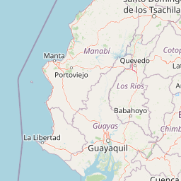
Map view of Machalilla National Park

Use this park location map to pinpoint Machalilla National Park in Ecuador, understand its exact geographic position, and read its mapped placement within the surrounding landscape more clearly.

Pigeon | © OpenStreetMap contributors

Location context for Machalilla National Park

Manabí Province
Park atlas

Trace the geographic spread of national parks and compare protected areas across Ecuador's Pacific region.

Explore Other National Parks and Protected Areas Near Machalilla National Park
Continue your discovery of protected areas by browsing other national parks and reserves located near Machalilla National Park in Ecuador's coastal region. Compare their unique ecological features, geographic settings, and conservation status to understand the broader protected landscape.
Watercolor illustration showing a mountain landscape with a snow-capped peak, a lake, and green hills.
National parkEcuador

Sangay National Park: Ecuador's National Park for Mapped Landscape and Geographic Discovery

Explore Ecuador's protected area boundaries and regional terrain.

Sangay National Park serves as a crucial protected landscape within Ecuador, offering rich opportunities for atlas and geography exploration. This page details the park's specific mapped boundaries and its natural terrain, providing essential context for understanding its place within South America's broader geographic tapestry. Investigate Sangay National Park's identity as a protected national park and its value for focused landscape and regional discovery.

Area
5,177.65 km²
Established
1979
IUCN
II
National parkPeru

Cerros de Amotape National Park: Peru's Protected Pacific Tropical Forest Atlas

Explore mapped boundaries and diverse terrain of this unique landscape.

Cerros de Amotape National Park stands as a significant protected area within Peru, meticulously preserving remnants of the Tumbes-Piura dry forests and Pacific tropical forests. Situated within the Cordillera de los Amotapes, the park features a dynamic landscape from riverine habitats to elevated mountain terrain. This park detail page offers an atlas-style view, focusing on its geographic context, mapped protected boundaries, and its importance as a conservation corridor for unique biodiversity.

Area
1,515.61 km²
Established
1975
IUCN
II
Relief
Mountain
National parkCotopaxi Province

Cotopaxi National Park: Ecuador's Mapped Protected Landscape and Regional Geography

Explore the geographic context of this national park.

Cotopaxi National Park represents a key protected landscape within Ecuador, located in Cotopaxi Province. This page facilitates detailed exploration of the park's mapped boundaries and its contribution to the regional geography. Understand the specific characteristics of this national park as part of a broader atlas of protected areas and natural terrains.

Area
333.93 km²
Established
1975
IUCN
II
Relief
Mountain
National parkEcuador

Llanganates National Park: Detailed Atlas Entry for Ecuador's Protected Landscape

Explore the mapped geography and regional context of this Ecuadorian national park.

Llanganates National Park is a designated national park offering rich opportunities for geographic and landscape exploration. As a significant protected area in Ecuador, it provides crucial context for understanding the country's natural terrain and the distribution of its conservation landscapes. This entry is designed to facilitate an atlas-style discovery of the park's location, boundaries, and its role within the broader geography of the region.

Area
2,197.07 km²
Established
1996
IUCN
II
Relief
Mountain
National parkEcuador

Podocarpus National Park: Ecuador's Diverse National Park and Protected Landscape

Discover elfin forests, paramo, and over 100 lagoons.

Podocarpus National Park, situated in southeastern Ecuador, stands as a prime example of a protected natural area at a unique biogeographic crossroads. This national park spans dramatic elevational zones, from montane rain forests to high-elevation paramo ecosystems dotted with more than 100 lagoons, offering rich mapped landscape exploration. Its significance lies in the convergence of four distinct ecological systems, contributing to exceptional biodiversity and a rich tapestry of natural terrain.

Area
1,462.8 km²
Established
1982
IUCN
II
Relief
Mountain
National parkZamora Chinchipe

Yacurí National Park: Protected Andean Lakes and Volcanic Landscape in Zamora Chinchipe

Discover highland geography and the ancient Inca Trail.

Yacurí National Park is a key protected landscape in Ecuador's southern Andes, celebrated for its remarkable collection of over 46 high-altitude lakes set within dramatic volcanic terrain. Situated in Zamora Chinchipe province, the park preserves a vital stretch of the Inca Trail, complete with archaeological sites. This national park offers a rich exploration of Andean geography, páramo ecosystems, and significant cultural heritage, making it a cornerstone of the region's protected areas.

Area
431 km²
Established
2009
IUCN
II
Relief
Mountain
National parkEcuador

Sumaco Napo-Galeras National Park: Ecuador's Volcanic National Park Landscape

Explore protected areas and biodiversity in the Andean-Amazon transition.

Sumaco Napo-Galeras National Park protects a dramatic volcanic landscape in Ecuador, showcasing a significant elevation gradient that supports diverse cloud forest and Amazonian rainforest habitats. This national park is recognized for its endemic species and rich avifauna, offering a compelling case study for understanding protected land geography and ecological transitions within South America.

Area
2,067.49 km²
Established
1994
IUCN
II
Relief
Mountain
Watercolor illustration of a mountain range with a lake in the foreground, green fields, and a colorful sky
Protected areaColombia

Galeras Protected Area: Exploring Colombia's Mapped Natural Landscapes

Discover the geography and protected terrain of Galeras.

The Galeras protected area in Colombia offers a distinct opportunity for geographic exploration, focusing on its defined boundaries and the natural landscape it encompasses. This resource details the park's setting within the Colombian geography, providing a map-centric view of its protected status. Understanding Galeras contributes to a broader appreciation of protected lands across South America and their unique terrain.

Relief
Mountain
Climate
Alpine
Access
Highly restricted

Common questions about visiting, size, designation, and location context for Machalilla National Park

Machalilla National Park FAQs for park facts, access, geography, and protected area context
Find quick answers about Machalilla National Park, including protected-area facts, park geography, trail and visitor context, and how the park fits into its surrounding country and regional landscape.
MoriAtlas Explorer

Continue Your Protected Areas Search Across the Global Atlas

Deepen your exploration by continuing the structured search for national parks and protected areas worldwide. Utilize the comprehensive filtering capabilities to compare different conservation landscapes and refine your understanding of global park geography. Discover more about the distribution and characteristics of protected natural areas.

Global natural geography
Machalilla National Park Ecuador: Protected Area Map & Geography