
Mori Atlas logo
Nature reserveMalchower Aue

A compact mosaic of peat-cutting ponds and swamp forests on the historic Barnim glacial plateau.

Malchower Aue Nature Reserve: Mapped Protected Landscapes and Glacial Terrain in Berlin

Malchower Aue protects a layered natural environment within Berlin, where the remnants of a lowland bog meet reclaimed spoil mounds and alder swamp forests. This nature reserve serves as an essential geographic focal point for understanding the interplay between historical peat extraction and urban environmental restoration. Its distinct geography, defined by seven peat-cutting ponds and varying moisture-level habitats, offers a unique window into the ecological character of the Barnim plateau.

nature reserveurban wetlandpeatlandlowland bogswamp forestpeat-cutting ponds
A graphic illustration showing a cascading waterfall flowing down between jagged rock formations, surrounded by coniferous trees under a bright sun.

Malchower Aue

Nature reserve

Park overview

Structured park overview, official facts, and landscape profile for Malchower Aue

Malchower Aue park facts, protected area profile, and essential visitor context

Review the core facts for Malchower Aue, including designation, size, terrain, visitor scale, habitats, and operating context in one park-focused overview.

About Malchower Aue

Malchower Aue occupies a modest but ecologically rich patch of land in the Lichtenberg borough of Berlin, surrounded by dense urban development and historical infrastructure. The reserve sits within the Barnim, a glacial plateau that shapes much of north-eastern Berlin and gives the surrounding localities their gently undulating terrain. A shallow meltwater channel, carved roughly 10,000 years ago at the end of the last ice age, defines the basic shape of the reserve and links it southward to the Malchower See.

What is protected today is a layered landscape shaped by multiple human interventions. Centuries of drainage turned the original wetland into meadowland; from the late nineteenth century onward, the broader area functioned as Berlin's Rieselfelder, or sewage irrigation fields, while parts of the reserve itself became allotment gardens. Between 1979 and 1983 the meadows were largely abandoned and large-scale peat extraction was carried out, leaving behind a distinctive group of small ponds. Smaller parts of the surface were filled with excavated soil and building debris from nearby housing developments, creating artificial elevations that now play an unexpected ecological role.

The significance of Malchower Aue lies in this unusual combination: a surviving fragment of lowland bog and alder swamp forest sits alongside distinctive peat-cutting ponds, while mound-shaped dry grassland adds a warm-loving vegetation element not normally associated with a lowland peat site. The reserve is also notable for its system of named walking and cycling paths, marked with green signs in the style of urban streets, which integrate the protected area into the everyday life of the surrounding neighbourhood and link it to the larger Volkspark Malchower See concept.

Since its formal protection in 1995, the site has been managed primarily for the preservation of its Niedermoorwiesen, peat-cutting features, and adjacent Bruchwald, the German term for waterlogged swamp forest dominated by alder. The combination of natural heritage, layered land-use history, and easy access from Berlin's eastern districts makes Malchower Aue a representative example of urban nature conservation in Germany.

Quick facts and research context for Malchower Aue

Malchower Aue is a designated nature reserve (Naturschutzgebiet) covering roughly 22.2 hectares in Berlin-Malchow, in the borough of Lichtenberg. It carries the official code NSG-27 and was placed under formal protection on 7 March 1995. The reserve sits on the Barnim, a glacial plateau north-east of central Berlin, and adjoins the Malchower See to the south.

Its core habitats include lowland peat bog remnants, wet meadows, alder swamp forest, a cluster of peat-cutting ponds with reed beds, and a small area of herb-rich and semi-dry grassland on old construction spoil. The site supports more than 300 higher plant species, about 40 bird species, several amphibians and fish, and a diverse dragonfly community.

Protection and recognition

Terrestrial conservation scope and official designation records for Malchower Aue

Malchower Aue Protection Status and Documented Protected Area Designation

Malchower Aue maintains a documented terrestrial protection status within official conservation databases. Recorded management metrics outline the administrative scope and baseline recognition details associated with the protected area.

Protection details

Protection scope
Terrestrial
Transboundary protection
No
WDPA ID
164560
Park context

Deeper park guide and search-rich context for Malchower Aue

Malchower Aue history, landscape, wildlife, and travel context

Explore Malchower Aue through its history, landscape character, ecosystems, wildlife, conservation priorities, cultural context, and seasonal travel timing in a structured park guide built for atlas discovery and search intent.

Why Malchower Aue stands out

Malchower Aue is best known as a compact urban nature reserve where glacial landscape history, centuries of peatland use, and modern urban development have all left their mark. Its core identity is built around a former lowland bog that was drained, mined for peat, partially backfilled with construction debris, and then set aside as a refuge for wetland and swamp-forest habitats. The reserve is particularly distinctive for its seven peat-cutting ponds, called Torfstiche, which are lined with reed and provide habitat for amphibians, dragonflies, and waterbirds. Equally notable is the unusual contrast between the wet lowland and the dry, warm-loving grassland patches on the old spoil mounds, an ecological juxtaposition rarely found within a single small protected site in Berlin.
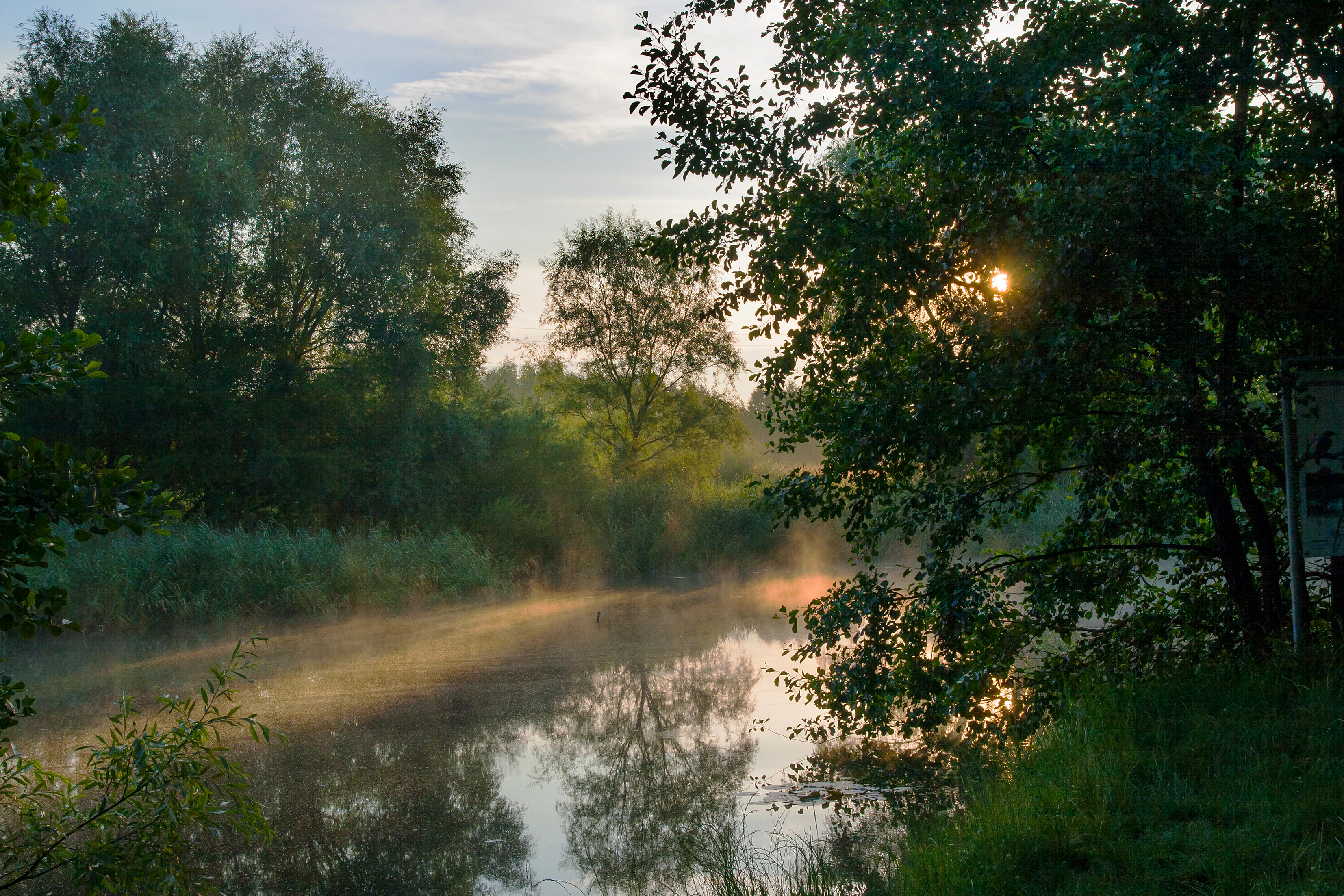
A peaceful nature scene in Malchower Aue, featuring a small, calm pond with morning mist floating above the water surface, surrounded by lush green trees and reeds, with sunbeams filtering through the foliage.
Morning mist rising over a pond in the Malchower Aue nature reserve.

Malchower Aue history and protected-area timeline

The history of Malchower Aue begins at the end of the Weichselian glaciation, when retreating ice released meltwaters that cut a shallow channel into the Barnim plateau. Over time this channel lost its open water through natural silting and peat formation, gradually transforming into a lowland bog whose southern end connected to the Malchower See.

In the eighteenth century, the moor was drained by a ditch that still exists today under the name Dorfgraben Malchow, and the resulting land was used as meadow. The reserve's history then became tied to the larger Malchower Rieselfelder, the sewage irrigation fields that supplied Berlin's wastewater management from 1884 to 1969 and largely defined the agricultural pattern of the surrounding area. In 1931, an allotment garden complex known as Kleingartenanlage Wiesenhöhe was established within what is now the reserve, and it was expanded in 1951.

During the 1970s and 1980s the site underwent dramatic physical change. Meadow use was largely abandoned in 1979, and extensive peat extraction took place between 1979 and 1983, producing the seven characteristic ponds that still define parts of the reserve today. Some of the excavated ground was filled with building rubble and excavated soil from the construction of the Hohenschönhausen-Nord prefabricated housing estate, built between 1981 and 1989. In 1985 planners proposed a Volkspark Malchower See that would have transformed the Malchower Aue spoil heaps into a winter-sports hill with a viewpoint, but the plan was halted by the political upheaval of 1989 and German reunification.

After 1990 the surrounding Plattenbau estates were renovated, and a concrete-rubble depot was added to the existing soil mound. In 1994 the two resulting hills were sealed with additional topsoil from the Linden-Center construction project, the depot was closed, and the landscape was redirected toward ecological rather than industrial use. Recognising the importance of the surviving peat meadows, peat cuts, and adjacent alder swamp forest, the state of Berlin formally designated the area as a nature reserve on 7 March 1995.

Malchower Aue landscape and geographic character

The landscape of Malchower Aue is shaped by the smooth, low-relief terrain of the Barnim, a glacial plateau that carries the scars of the last ice age. The defining feature is a north-south meltwater channel, now almost fully vegetated, that once connected northward across the plateau and today drains southward toward the Malchower See at the reserve's southern edge.

Within this broader setting the reserve presents a mixture of gently undulating wetland and several distinct man-made elevations. The flat lowland is occupied by wet meadows, varying degrees of degraded peatland, and patches of alder swamp forest where the ground stays saturated throughout much of the year. Scattered across this floor are seven small peat-cutting ponds, each surrounded by reed beds, which together form one of the most recognisable visual signatures of the reserve.

In the south-eastern part of the site the otherwise low terrain rises into a pair of hills created by the deposition of construction spoil. After the loading of rubble and soil stopped, the mounds were sealed and revegetated, and today they support a community of warm-loving grasses and herbs that contrasts sharply with the wet surroundings. A viewpoint on top of the higher mound offers an elevated outlook over the wetland below and gives a sense of the reserve's compact yet varied relief.

Malchower Aue ecosystems, habitats, and plant life

Ecologically, Malchower Aue functions as a small but unusually diverse patch of wet and dry habitat pressed against the urban fabric of eastern Berlin. Its core is built around the remains of a lowland bog, or Niedermoor, whose peat-forming plant communities survive mainly as fragments. Surrounding these remnants are damp meadows, alder-dominated swamp forest, and a network of peat-cutting ponds bordered by reeds where open water and emergent vegetation coexist.

The site's vegetation structure is sharply layered. On the low ground, typical wetland species dominate, while the artificially elevated areas in the south-east have been colonised by warmth-loving plants typical of drier substrates, including elements characteristic of semi-dry grasslands, an unusual vegetation type in a setting otherwise defined by peatland and swamp. Scattered pollarded willows add a structurally old and biologically rich element to the landscape.

The reserves also contains herb-rich grassland communities and varied transitional zones between wet meadow, reed bed, swamp forest, and dry mound. These transitions create the edge habitats that support many of the site's animal species, particularly invertebrates, amphibians, and birds. The combination of water, reed, open meadow, woodland, and dry grassland within a single small site gives Malchower Aue a disproportionately high ecological richness for its area.

Malchower Aue wildlife and species highlights

The wildlife of Malchower Aue reflects the diversity of its habitats and the proximity of the reserve to larger wetlands associated with the Malchower See and Berlin's broader waterway network. More than 300 species of higher plants have been recorded, alongside roughly 40 bird species, six amphibian species, seven fish species, and the larvae of about 20 different dragonflies.

Among the more notable bird species are breeding or regularly occurring wetland and scrub species such as the kingfisher, penduline tit, reed warbler, reed bunting, and tufted duck, and the area also hosts transient and feeding visitors such as the white stork. The mix of wet meadow, reeds, and adjacent dry grassland supports whinchat, goldfinch, and common nightingale, while the swamp-forest patches and wooded edges attract woodpeckers, including the green woodpecker.

Amphibians are particularly well represented, reflecting the importance of the peat-cutting ponds as breeding habitat. Common toads and common frogs breed in and around the open water, while dragonfly larvae thrive in the still, vegetated pools. Fish populations include the three-spined stickleback, which tolerates the shallow, variable conditions of the ponds. The reserve's small mammals include the harvest mouse, often associated with tall reed and grass stands. Pollinators and other invertebrates are also notable, with recorded species such as the swallowtail butterfly, the common blue, and the six-spot burnet moth.

Malchower Aue conservation status and protection priorities

The conservation significance of Malchower Aue lies in its role as a refuge for a peatland-related ecosystem inside a heavily urbanised capital city. Designated as a Naturschutzgebiet on 7 March 1995 under the code NSG-27, it protects one of the few surviving fragments of lowland bog and alder swamp forest within Berlin's Lichtenberg district.

The reserve is valued for preserving the chain of small peat-cutting ponds and their fringe of reeds, which are now a scarce habitat type in the city. Equally important is the site's small remnant of true Bruchwald, or waterlogged alder swamp forest, a habitat that has been historically reduced across Brandenburg and Berlin through drainage and conversion to other land uses.

The 1995 designation was also aimed at halting further damage to the remaining peat meadows and at stabilising the unique juxtaposition of wet and dry habitats that had emerged after decades of peat extraction, dumping, and partial recovery. Because of these qualities, Malchower Aue is recognised not only as a local nature reserve but as an element within the larger network of protected sites across Berlin contributing to the conservation of wetland and peatland habitats in a metropolitan setting.

Malchower Aue cultural meaning and human context

Malchower Aue sits within the historic village landscape of Berlin-Malchow, one of the older rural settlements that was gradually absorbed into the expanding city. The traditional relationship between the village and its surrounding wet land shaped centuries of land use, from meadowland farming to the drainage works of the eighteenth century that still define the area's hydrology today.

A particularly distinctive late-modern chapter is the reserve's role in Berlin's Rieselfeld system, the sewage irrigation fields that operated from 1884 to 1969. Although most Rieselfelder have since been redeveloped, the Malchower Aue preserves a small fragment of that infrastructure's legacy within a predominantly natural context. The site's allotment gardens, founded in 1931 and expanded in 1951, also reflect a broader German tradition of small-scale urban gardening that continues in many neighbourhoods.

The reserve's network of named paths, marked with green signs and white lettering in the style of city streets, is a more recent cultural expression. This naming system echoes urban Berlin traditions and makes the protected area feel like an extension of the local community's everyday space. The Max-und Herta Naujocks-Weg, the most prominent of these paths, links the reserve to the village, the lake, and the wider district, reinforcing the sense that Malchower Aue is as much a part of local identity as it is a piece of ecological infrastructure.

Top sights and standout views in Malchower Aue

A compact nature reserve that combines surviving lowland bog, alder swamp forest, and a chain of peat-cutting ponds with a surprisingly dry, warm-loving grassland on old spoil mounds. A protected fragment of the Barnim glacial plateau in the middle of eastern Berlin, with more than 300 recorded plant species and a rich dragonfly and amphibian fauna. A layered cultural landscape telling the story of drainage, sewage irrigation, peat extraction, post-war housing construction, and reunification-era restoration. A named network of walking and cycling paths, including the Max-und Herta Naujocks-Weg, that integrate the reserve into the everyday life of the surrounding neighbourhood.

Best time to visit Malchower Aue

Malchower Aue can be appreciated throughout much of the year, but the warmer months generally bring out its character most fully. Late spring and early summer highlight the wetland edges, when reeds and meadow plants are in full growth and amphibians are most active around the peat-cutting ponds. Summer offers the best chance to see dragonflies and butterflies along the transition zones between wet and dry habitat, and to experience the warm-loving grassland on the spoil mounds at its most expressive.

Autumn brings its own appeal through the changing colours of the alder swamp forest and the arrival of migratory and wintering waterbirds associated with the broader wetland network around the Malchower See. In winter the open landscape is largely exposed, the ponds and reeds become quieter, and the elevated viewpoint on the spoil mound offers one of the clearest overviews of the reserve's shape and structure. Because the site has a network of formal paths integrated into the urban fabric, quiet weekday visits can be especially rewarding for those seeking close observation of birds, amphibians, and insects.

Monthly climate preview

Long-term monthly temperature averages and precipitation records for Malchower Aue

Malchower Aue Climate Normals and Measured Temperature Patterns

Historical climate data for Malchower Aue records a measured annual temperature range from sub-zero winter minimums to warm summer maximums alongside steady monthly precipitation. Examining the complete twelve-month normals provides detailed insight into long-term atmospheric patterns across the protected coordinate.
Annual mean9 °C
-1 °C20 °C
Jan-1°
Feb
Mar
Apr
May14°
Jun18°
Jul20°
Aug20°
Sep15°
Oct
Nov
Dec
Warmest month
July

20.3 °C

Coolest month
January

-0.9 °C

Wettest month
July

2.4 mm/day

Driest month
April

1.1 mm/day

Park location guide

Geography guide, regional context, and park location map for Malchower Aue

Malchower Aue park geography, regions, and map view in Germany

Understand where Malchower Aue sits in Germany through a broader geographic reading of the surrounding landscape, nearby location context, and its mapped position within the national park landscape.

How Malchower Aue fits into Germany

Germany is a federal republic in Western and Central Europe with a population of over 83 million across sixteen constituent states. It is Europe's largest economy by nominal GDP and a major global exporter and importer. The capital is Berlin, and the country borders Denmark, Poland, Czech Republic, Austria, Switzerland, France, Luxembourg, Belgium, and the Netherlands.

Wider geography shaping Malchower Aue in Germany

Germany is located in Western and Central Europe, spanning 357,022 km². It borders Denmark to the north, Poland and the Czech Republic to the east, Austria and Switzerland to the south, and France, Luxembourg, Belgium, and the Netherlands to the west. The country has coastlines on the Baltic Sea and North Sea to the north, with the Alps located in the southern region.

Map view of Malchower Aue

Use this park location map to pinpoint Malchower Aue in Germany, understand its exact geographic position, and read its mapped placement within the surrounding landscape more clearly.

Pigeon | © OpenStreetMap contributors

Location context for Malchower Aue

Berlin

Explore photographic records of wetland habitats, peat ponds, and glacial terrain.

Malchower Aue Photos and Landscape Scenery: Visualizing the Protected Urban Wetland

Visual documentation captures the varied terrain of Malchower Aue, spanning rewilded peat-cutting ponds, swamp forests, and dry grassland mounds. Photographic records clarify the ecological character of this urban protected area by revealing distinct wetland habitats.

A peaceful nature scene in Malchower Aue, featuring a small, calm pond with morning mist floating above the water surface, surrounded by lush green trees and reeds, with sunbeams filtering through the foliage.

A still pond reflecting leafless trees and blue sky under bright daylight, with golden reeds on the bank.

Park atlas

Compare surrounding regional geography and connected protected landscapes

Parks Near Malchower Aue: Discover Other Protected Areas and Wetland Reserves

Browse other parks near Malchower Aue to examine similar wetland habitats, glacial plateaus, and urban nature reserves across the surrounding region. Continuing into adjacent protected areas provides valuable geographic context for comparing lowland bogs, swamp forests, and restored conservation zones.
A watercolor painting of a flat, marshy landscape with soft green trees in the midground and pale hills under a light sky in the background.
Nature reserveBerlin
About 3.4 km away#1 closest

East

Falkenberger Rieselfelder Nature Reserve: A Detailed Atlas of Berlin Protected Lands

Reclaimed wetland geography and urban conservation habitats

Falkenberger Rieselfelder acts as an ecologically rich refuge where former industrial irrigation fields have been repurposed into a mosaic of seasonal pools and meadows. Located on the urban fringe of Berlin, this nature reserve offers a unique look at how conservation grazing and habitat management support species like the great crested newt within a dense metropolitan region.

Area
0.881 km²
Established
1995
IUCN
IV
Relief
Lowland
Nature reserveBerlin
About 4.8 km away#2 closest

Southeast

Unkenpfuhle Marzahn Nature Reserve: Geographic Context and Protected Landscape Map

Urban amphibian habitat in Berlin, Germany

Unkenpfuhle Marzahn is a protected nature reserve spanning over three hectares of glacial moraine terrain in Berlin. The site provides a critical haven for threatened amphibians, featuring a unique combination of wetland ponds, reedbeds, and dry grassland habitats tucked between urban and cemetery zones.

Area
0.033 km²
Established
2001
IUCN
IV
Scope
Terrestrial
A horizontal watercolor painting depicting a marshy landscape with ponds, green vegetation, and soft distant hills against a light background.
Nature reserveBerlin
About 5 km away#3 closest

Northwest

Karower Teiche Nature Reserve: Mapped Protected Wetland Geography in Northeast Berlin

Transitional lowland fen and pond mosaic

Karower Teiche protects a unique 128 hectare wetland mosaic in the Pankow district of Berlin. Centered on four shallow ponds and extensive reedbeds, the reserve maintains a vital ecological corridor between the Barnim plateau and the Berlin glacial valley. This site provides essential habitat for amphibians and reed-specialist birds within an urban setting.

Area
1.286 km²
Established
1994
IUCN
IV
Relief
Lowland
Watercolor illustration showing a soft landscape with a pond, marsh vegetation, and a background of rolling hills or meadows.
Nature reserveBerlin
About 7.4 km away#4 closest

North

Mittelbruch Nature Reserve: Mapped Wetland Geography and Protected Landscape in Berlin

Examining lowland peat diggings and protected moorland ecosystems

Mittelbruch stands as a compact nature reserve in northeastern Berlin, featuring a layered landscape of former peat diggings and open moor meadows. This area plays a critical role in urban conservation by providing essential refuge for waterbirds and diverse meadow flora. Utilize the atlas to study the reserve's internal geography, including its managed reed belts and surrounding forest edges that form a distinct ecological mosaic within the city landscape.

Area
0.282 km²
Established
1997
IUCN
IV
Relief
Lowland
A horizontal watercolor illustration of a wetland scene with soft pink and green tones, showing sparse trees on the banks of a shallow, marshy water area under a pale sky.
Nature reserveBrandenburg
About 7.8 km away#5 closest

North

Ausstichgelände Röntgental: Brandenburg Nature Reserve and Protected Wetland Atlas

Mapped ecological landscapes on the Berlin metropolitan fringe

Investigate the detailed geography of Ausstichgelände Röntgental, a compact nature reserve in Brandenburg. Formed from nineteenth-century railway sand quarries, this protected area features a diverse mosaic of reed beds, open water, and alder carr forest. The site provides a compelling case study of post-industrial ecological recovery within the broader Barnim Nature Park landscape.

Area
0.248 km²
Established
1990
IUCN
IV
A soft watercolor painting featuring green grasses in the foreground, calm water, and a tree line along the horizon.
Nature reserveBrandenburg
About 9.8 km away#6 closest

Northwest

Schönerlinder Teiche Nature Reserve in Brandenburg: Protected Landscape and Geographic Atlas

Explore the wetland mosaic, bird-rich ponds, and grazing conservation areas

Schönerlinder Teiche offers a rare look at post-agricultural land transformation, featuring ponds, meadows, and reed habitats in the Brandenburg region. This nature reserve serves as an essential bird sanctuary and educational site, with water buffalo and Konik horses contributing to ongoing habitat maintenance. View the detailed geography of this protected area and its role within the wider Barnim Nature Park network.

Area
0.408 km²
Established
1997
IUCN
IV
Relief
Lowland
A watercolor illustration of a rural landscape with low hills, trees, and grassy meadow areas.
Nature reserveBrandenburg
About 9.9 km away#7 closest

North

Faule Wiesen bei Bernau Nature Reserve: Mapped Landscapes and Geography of Brandenburg

A vital Panke river corridor protecting rare meadow and woodland biomes.

Spanning 37 hectares near the northern edge of Berlin, Faule Wiesen bei Bernau offers a study in contrasting landscapes. The reserve features open wet meadows and small ponds alongside sandy dry grasslands and oak woodlands. It remains an essential ecological link within the Barnim district, preserving critical habitats for amphibians and orchids within the broader Brandenburg geography.

Area
0.37 km²
Established
2000
Relief
Lowland
Scope
Terrestrial
A horizontal watercolor illustration showing a pinkish-purple foreground of heathland vegetation transitioning into a line of light green trees against a pale, washed-out hilly background.
Nature reserveBrandenburg
About 11 km away#8 closest

North

Schönower Heide Nature Reserve: An Atlas View of Brandenburg Protected Heathlands

A restored landscape of glacial dunes and sandy heath

Schönower Heide stands as a significant nature reserve in Brandenburg, Germany. The area protects a unique combination of open sand heath, pine woodland, and wetland meadows formed on post-glacial outwash plains. This protected landscape is recognized for its successful transition from former military terrain into a vibrant habitat for diverse flora and fauna, including managed populations of red deer and mouflon within its fenced boundaries.

Area
5.334 km²
Established
2000
IUCN
V
Relief
Lowland

Common questions about visiting, size, designation, and location context for Malchower Aue

Malchower Aue FAQs for park facts, access, geography, and protected area context

Find quick answers about Malchower Aue, including protected-area facts, park geography, trail and visitor context, and how the park fits into its surrounding country and regional landscape.
MoriAtlas Explorer

Continue Your Protected Areas Search Across the Global Atlas

Deepen your exploration by continuing the structured search for national parks and protected areas worldwide. Utilize the comprehensive filtering capabilities to compare different conservation landscapes and refine your understanding of global park geography. Discover more about the distribution and characteristics of protected natural areas.

Global natural geography