Mori Atlas logo
Nature reserveMaliau Basin

Examining the circular escarpments, internal river network, and highland topography of this primary forest wilderness.

Maliau Basin Nature Reserve: An Analysis of Borneo's Protected Sandstone Catchment Geography

(Maliau Basin Conservation Area)

Maliau Basin stands as a geographically distinct nature reserve in Sabah, Malaysia, defined by its near-circular sandstone escarpments and isolated river system. This protected wilderness spans over 588 square kilometers, featuring a deep forested interior that rises from lowland valleys to the peaks of Mount Lotung. By tracing the hydrography of the Maliau River and the complex ridge-and-valley structure, this resource provides an authoritative look at one of the least-disturbed ecological zones in Borneo.

tropical rainforestbasin landscapesandstone escarpmentstrict nature reserveprimary forestlowland forest

Maliau Basin

Nature reserve

Park overview

Structured park overview, official facts, and landscape profile for Maliau Basin

Maliau Basin park facts, protected area profile, and essential visitor context

Review the core facts for Maliau Basin, including designation, size, terrain, visitor scale, habitats, and operating context in one park-focused overview.

About Maliau Basin

Maliau Basin is one of the most remarkable protected natural areas in Southeast Asia, occupying a vast and remote tract of central Sabah on the island of Borneo. What sets the basin apart from many other reserves in the region is the way its geography has preserved it: a roughly circular sandstone depression, ringed by towering escarpments, with only a single outflow through a southeastern gorge where the Maliau River escapes to join the Kuamut and, ultimately, the great Kinabatangan River system. This unique hydrological isolation has helped shield the interior from extensive human disturbance and, together with its inaccessibility, has left much of the basin uncharted until relatively recent times.

The protected area encompasses a wide gradient of environments, from lowland and hill dipterocarp forests through lower montane zones and up to true upper montane cloud forest near the summit of Mount Lotung. The basin's combination of high rainfall, varied elevation, and unbroken forest cover supports an exceptional range of plant and animal communities. Researchers and explorers have long regarded the area as a living laboratory, and the opening of the Maliau Basin Studies Centre in 2011 has cemented its role as a focal point for field-based scientific study, biodiversity surveys, and conservation training in Malaysian Borneo.

Equally important is the basin's cultural and symbolic identity. With no record of permanent indigenous settlement inside the basin itself, Maliau has taken on an almost mythical status, often referred to as the Lost World of Borneo. That mystique, paired with its growing recognition in scientific and conservation circles, has made it a key candidate area for UNESCO World Heritage status and a flagship of Sabah's effort to protect large, ecologically coherent landscapes for the long term.

Quick facts and research context for Maliau Basin

Maliau Basin lies in central Sabah, Malaysia, on the island of Borneo, within the Tongod District of the Sandakan Division. The protected area covers roughly 588 square kilometers, of which about 390 square kilometers consist of pristine primary forest. It is classified as an IUCN Category Ia strict nature reserve and is administered by Yayasan Sabah. The basin forms a single integrated catchment drained essentially by one river, the Maliau River, which exits southeast through a gorge and eventually joins the Kinabatangan, the largest river system in Sabah.

Park context

Deeper park guide and search-rich context for Maliau Basin

Maliau Basin history, landscape, wildlife, and travel context

Explore Maliau Basin through its history, landscape character, ecosystems, wildlife, conservation priorities, cultural context, and seasonal travel timing in a structured park guide built for atlas discovery and search intent.

Why Maliau Basin stands out

Maliau Basin is best known for its near-circular sandstone basin encircled by dramatic escarpments, a single-river catchment that drains an enormous forested interior, and a sense of being one of the last truly unexplored wilderness areas on Borneo. The region's famous landmarks include Mount Lotung, which rises to about 1,667 meters, the spectacular tiered Maliau Falls, and the highland Lake Linumunsut, each contributing to the basin's reputation as a landscape of unusual geological isolation and ecological integrity.
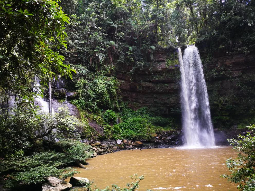
A waterfall drops over a rocky ledge into a calm, brownish pool, surrounded by lush green rainforest vegetation.
A waterfall cascades into a pool within the dense tropical rainforest of the Maliau Basin.

Maliau Basin history and protected-area timeline

Maliau Basin's modern history is closely tied to the conservation agenda of Sabah and the leadership of the Yayasan Sabah Group. In 1981, the Sabah Foundation, the Yayasan Sabah, formally designated the basin as a conservation area, recognizing its exceptional ecological value and the need to protect it from the logging pressures that were transforming much of Borneo at the time. This early designation placed Maliau among the first major rainforest areas in Sabah to receive formal protection focused specifically on preserving its natural character.

The conservation status of the basin was significantly strengthened in 1997, when the Sabah State Assembly gazetted the area as a Protection Forest Reserve under the highest protection class, Class I. The gazetted area, totaling approximately 588 square kilometers, locked in a legal framework designed to keep the basin off-limits to commercial extraction and large-scale development, cementing its role as a strict nature reserve under IUCN Category Ia guidelines.

A pivotal moment for the basin's future as a research and education site came in 2011, with the opening of the Maliau Basin Studies Centre. This sizeable field facility provides a base for naturalists, biologists, and university field courses, including long-running partnerships with institutions such as Sheffield University, Griffith University, and Otago University, as well as citizen-science initiatives like Taxon Expeditions. Since then, efforts have continued to recognize the basin's global significance through a nomination process aimed at securing UNESCO World Heritage Site inscription.

Maliau Basin landscape and geographic character

The defining feature of Maliau Basin's landscape is its near-perfect circular form when viewed from above, a bowl-like depression carved into sandstone bedrock and ringed by towering, near-continuous escarpments. These cliffs form a formidable natural wall around the basin, giving the interior a sense of deep isolation and protecting it visually and physically from the surrounding lowlands. The single outflow point, where the Maliau River escapes southeast through a narrow gorge, is one of the most distinctive hydrological features of any protected area in Borneo.

Inside the encircling cliffs, the terrain rises gradually from lowland forest floors through increasingly steep hill country and ultimately to the upper slopes of Mount Lotung, which reaches about 1,667 meters and forms the basin's highest point. Between these extremes lie a wide range of landforms, including broad forested valleys, undulating ridges, deep drainage lines, and hidden plateau-like areas. The basin is also home to several striking individual features, including the multi-tiered Maliau Falls, where the Maliau River plunges dramatically over a sandstone lip into a series of cascades, and the high-elevation Lake Linumunsut, a montane lake that adds to the diversity of aquatic and wetland habitats within the otherwise forest-dominated interior.

The overall impression of the basin is one of immense scale and geological coherence. Although it is not a high-mountain landscape in the alpine sense, the combination of steep escarpments, deeply dissected valleys, a high central peak, and extensive undisturbed forest canopy gives Maliau a sweep and visual drama unusual for lowland-dominated tropical reserves. Heavy rainfall, persistent mists at higher elevations, and the dark, dense forest cover contribute to an atmosphere that has long reinforced the area's reputation as one of the wildest and least-explored corners of Borneo.

Maliau Basin ecosystems, habitats, and plant life

Maliau Basin's nature is defined by the extraordinary ecological gradient compressed within a relatively small geographical area. From the basin's outer lowlands, through hill forests, into lower montane forest, and finally up into the upper montane cloud forest cloaking the higher slopes of Mount Lotung, the reserve captures almost the full vertical spectrum of Bornean rainforest types. This elevation range, set within a single integrated catchment, creates overlapping ecological zones where species from different forest strata and climatic regimes can occur in close proximity.

The result is a high-density mosaic of plant communities. Lowland and hill dipterocarp forests contribute the towering hardwood trees for which Borneo is famous, while the transition into montane forest brings in mossy, stunted trees, abundant epiphytes, and a different cast of orchids and ferns. The sandstone geology underlying much of the basin influences soil chemistry, drainage patterns, and vegetation composition, giving parts of Maliau a distinctive botanical signature compared with areas elsewhere in Sabah.

The persistent high humidity, heavy rainfall, and large expanses of unbroken canopy support a thriving understory as well, with rich layers of seedlings, saplings, shrubs, climbers, and ground herbs. Lake Linumunsut and the river systems feeding the famous Maliau Falls add freshwater habitats that are integral to the basin's biodiversity. Together, these features make the basin not just a large protected area, but a landscape in which ecological processes, from watershed function to nutrient cycling, can still operate across an unusually wide and continuous natural range.

Maliau Basin wildlife and species highlights

Maliau Basin's wildlife profile reflects its status as one of the most intact forest landscapes remaining on Borneo. The unbroken cover and altitudinal range provide habitat for many of the characteristic mammal species of Sabah, including several that depend heavily on large, undisturbed forest blocks. The basin's habitats support populations of orangutans, gibbons, bearded pigs, and various deer species, as well as smaller mammals such as squirrels, civets, and bats that fill important roles in the forest ecosystem.

Predators and other wide-ranging species also rely on the basin. The Sunda clouded leopard, one of Borneo's apex carnivores, has been documented in the area, alongside smaller cats and a range of mustelids. The river systems and surrounding wetlands further sustain wildlife typical of Bornean forest catchments, including otters along the watercourses and fish assemblages that contribute to the broader food web.

Birdlife is particularly rich across the elevation gradient, with lowland species giving way to montane and sub-montane forms on the slopes of Mount Lotung. Raptors, hornbills, pheasants, and broadbills are among the groups that characterize the basin's avifauna, and the combination of accessible edges, deep interior forest, and isolated highland plateaus creates conditions for interesting endemism and relict populations. Reptiles and amphibians likewise benefit from the basin's humidity and habitat diversity, with the network of streams, pools, and moist forest floors supporting a varied herpetofauna that continues to be a focus of ongoing biological surveys.

Maliau Basin conservation status and protection priorities

Maliau Basin Conservation Area holds an exceptional level of conservation significance within Sabah and across the broader Bornean landscape. Because the basin was never opened to commercial logging on a large scale, and because its encircling escarpments have historically impeded road-building and settlement, it retains an unusually continuous forest cover and a high degree of ecological integrity. This sets it apart from many neighboring forested areas in Sabah that have experienced various forms of habitat fragmentation or selective exploitation.

The layered protection status of the basin, from the 1981 Yayasan Sabah designation to the 1997 Class I Protection Forest Reserve gazettement, provides one of the strongest legal frameworks for conservation in the state. As an IUCN Category Ia strict nature reserve, the area is managed primarily for science, ecosystem protection, and the preservation of natural processes, rather than for tourism development or resource extraction. The opening of the Maliau Basin Studies Centre in 2011 marked a new phase, formalizing the area's role as a long-term site for biodiversity research, ecological monitoring, and capacity-building for conservation scientists across the region.

Ongoing efforts to secure UNESCO World Heritage recognition reflect the basin's growing recognition not just as a regional treasure but as a site of global natural heritage value. Its combination of geological singularity, watershed function as a single-river catchment draining into the Kinabatangan, altitudinal habitat diversity, and largely untouched primary forest makes Maliau Basin a benchmark for evaluating the importance of large, coherent, strictly protected areas in tropical Southeast Asia. Its continued integrity is closely tied to the broader conservation outlook for central Sabah and for the rainforests of Borneo as a whole.

Maliau Basin cultural meaning and human context

Maliau Basin has not supported permanent human settlement within its interior, and this absence of long-term habitation is itself a defining element of the basin's cultural identity. Surrounding communities in Sabah have traditionally regarded the area as remote and formidable, an image reinforced by the towering sandstone walls and the practical difficulty of entering the basin without specialized expedition support. The term frequently applied to Maliau, that of a Lost World of Borneo, reflects this long-standing perception of the area as a place set apart, both physically and culturally, from the more heavily inhabited lowlands.

Modern cultural engagement with Maliau is shaped primarily through scientific and educational partnerships rather than through tourism or traditional land use. The Maliau Basin Studies Centre has become a meeting point for researchers, students, and conservationists from Malaysia and abroad, building a contemporary heritage of fieldwork, exploration, and citizen-science contributions that continues to define the basin's identity. Meanwhile, the area's growing recognition within global conservation networks has begun to weave it into wider narratives about the importance of protecting Borneo's remaining primary rainforest for future generations.

Top sights and standout views in Maliau Basin

Maliau Basin's highlights center on its geographic singularity: a near-perfectly circular sandstone basin, enclosed by escarpments up to 1,600 meters and drained by essentially a single river, the Maliau, which escapes through a southeastern gorge. Within this dramatic ring stand Mount Lotung as the basin's high point, the cascading Maliau Falls, and the montane Lake Linumunsut, each adding distinct character to a landscape that has remained essentially unexplored at any large scale until recent decades.

Equally defining are the conservation dimensions: 588 square kilometers of legally protected terrain, including about 390 square kilometers of primary forest, managed by Yayasan Sabah as a strict nature reserve. Combined with the presence of the Maliau Basin Studies Centre, ongoing World Heritage candidacy, and a documented fauna that includes orangutans, gibbons, the Sunda clouded leopard, and a rich avifauna, the basin stands out as one of the most ecologically coherent and geographically distinctive protected areas in all of Borneo.

Best time to visit Maliau Basin

Maliau Basin lies in a region of high and relatively even rainfall throughout the year, so any visit will involve warm, humid conditions and a strong likelihood of rain. Periods of slightly drier weather, where forest trails remain passable and river crossings are less challenging, tend to be favored for expeditions into the basin, while the wetter months bring heavier downpours but also the most dramatic flow at Maliau Falls and the most luxuriant, mist-laden atmosphere across the highland forests.

Because access to Maliau Basin requires organized expeditions and passage through difficult terrain, timing decisions are typically driven less by peak tourism seasons and more by research schedules, river conditions, and the desire to experience particular ecological phenomena, such as fruiting events that draw wildlife into more visible activity. Visitors should generally expect consistently tropical conditions, with cooler, mistier weather at higher elevations around Mount Lotung and Lake Linumunsut regardless of the time of year.
Monthly climate preview

Long-term monthly temperature and precipitation averages for Sabah

Maliau Basin Climate Normals and Annual Temperature Rhythm

Representative coordinates record consistent annual temperature ranges alongside measured monthly precipitation variations for Maliau Basin. Exploring the complete twelve-month record provides detailed climate normals and deeper monthly comparisons for conservation geography.
Annual mean24 °C
23 °C25 °C
Jan23°
Feb24°
Mar24°
Apr25°
May25°
Jun24°
Jul24°
Aug24°
Sep24°
Oct24°
Nov24°
Dec24°
Warmest month
May

24.8 °C

Coolest month
January

23.4 °C

Wettest month
October

9 mm/day

Driest month
March

4.7 mm/day

Park location guide

Geography guide, regional context, and park location map for Maliau Basin

Maliau Basin park geography, regions, and map view in Malaysia

Understand where Maliau Basin sits in Malaysia through a broader geographic reading of the surrounding landscape, nearby location context, and its mapped position within the national park landscape.

How Maliau Basin fits into Malaysia

Malaysia is a federal constitutional monarchy located in Southeast Asia. The country consists of 13 states and three federal territories, divided by the South China Sea into Peninsular Malaysia on the Indochinese Peninsula and East Malaysia on the island of Borneo. With a population of over 34 million, it achieved independence from Britain in 1957 and became a modern federation in 1963. The country is recognized for its multicultural population, tropical climate, and significant economic role in the region.

Wider geography shaping Maliau Basin in Malaysia

Malaysia occupies a strategic position in Southeast Asia, split by the South China Sea into two distinct regions. Peninsular Malaysia lies on the Indochinese Peninsula, sharing a land border with Thailand to the north and maritime borders with Singapore, Vietnam, and Indonesia. East Malaysia occupies the northern portion of Borneo, sharing land borders with Brunei and Indonesia, and maritime borders with the Philippines and Vietnam. The country's terrain includes coastal plains, mountain ranges such as the Titiwangsa in the peninsula, and extensive tropical rainforests.

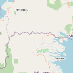
Map view of Maliau Basin

Use this park location map to pinpoint Maliau Basin in Malaysia, understand its exact geographic position, and read its mapped placement within the surrounding landscape more clearly.

Pigeon | © OpenStreetMap contributors

Location context for Maliau Basin

Sabah

Visual reference collection for sandstone escarpments, primary forests, and remote Borneo terrain.

Maliau Basin Photos, Landscape Scenery, and Protected Area Views

Visual records capture the dramatic topography, towering sandstone escarpments, and dense primary forests defining the Maliau Basin protected area. Examining national park photography reveals the geological isolation, watershed features, and varied lowland habitats characterizing this remote Borneo wilderness.

A waterfall drops over a rocky ledge into a calm, brownish pool, surrounded by lush green rainforest vegetation.

Park atlas

Compare surrounding protected landscapes and regional wilderness reserves

Explore Parks Near Maliau Basin and Related Protected Areas in the Region

Browse nearby national parks and protected areas sharing the remote forest geography of the surrounding region. Extending the search provides deeper context into regional conservation zones and adjacent rainforest habitats.
A soft watercolor painting of a winding river flowing through a lush, misty green forest under pale hills.
Wildlife reserveSabah
About 86 km away#1 closest

East

Danum Valley Conservation Area: Protected Lowland Rainforest Geography in Sabah

Examining the boundaries and terrain of this Bornean wildlife reserve

Danum Valley Conservation Area serves as a primary site for understanding undisturbed lowland dipterocarp forest in Borneo. This wildlife reserve features a complex bowl shaped basin of rivers, ridges, and dense tropical canopy. Access geographic maps and site data to understand the structural integrity of this protected region located within the state of Sabah.

Area
438 km²
Established
1980
IUCN
Ia
Relief
Highland
National parkNorth Kalimantan
About 105 km away#2 closest

Southwest

Kayan Mentarang National Park: A Protected Landscape in North Kalimantan

Explore Borneo's critical protected area and its vast forest geography.

Kayan Mentarang National Park is an immense protected area in North Kalimantan, Indonesia, renowned for being a crucial part of the Heart of Borneo conservation initiative. This national park encompasses over 13,600 square kilometers of primary tropical rainforest, sheltering diverse montane and lowland habitats along the Indonesia-Malaysia border. Its importance lies in its vast, contiguous landscape, critical role in regional biodiversity, and its representation of one of Southeast Asia's last great wilderness expanses, offering significant insight into mapped protected areas.

Area
13,605 km²
Established
1996
IUCN
II
Scope
Mixed
National parkMalaysia
About 118 km away#3 closest

Northwest

Crocker Range National Park: A Protected Landscape within Malaysia's Borneo Region

Mapped boundaries and regional geography context for exploration.

Crocker Range National Park represents a significant protected area within Malaysia, contributing distinct geographic features and landscape context to the Borneo region. This detailed view supports atlas exploration by outlining the park's mapped boundaries and its role within the nation's protected lands. Understand the park's specific location and geographic identity, enriching your comprehension of Malaysian natural landscapes and conservation areas.

Area
1,399 km²
Established
1984
IUCN
II
Relief
Mountain
National parkSabah
About 121 km away#4 closest

Southeast

Tawau Hills National Park: Mapped Boundaries and Protected Landscape Identity in Sabah

Explore the geographic scope and regional context of Tawau Hills National Park.

Gain a structured understanding of Tawau Hills National Park as a protected area within the geography of Sabah, Malaysia. This resource details its significance as a national park, highlighting its mapped landscape and its contribution to the regional geographic context. Ideal for users interested in atlas exploration and comprehending the distribution of protected lands.

Area
280 km²
Established
1979
IUCN
II
Relief
Mountain
National parkMalaysia
About 149 km away#5 closest

North

Kinabalu National Park: Mapped Boundaries and Protected Landscape Atlas

Exploring Malaysia's Natural Terrain and Park Geography

Delve into the specific protected area identity of Kinabalu National Park, situated within Malaysia. This resource details its geographic scope and mapped terrain, providing a foundation for understanding its role as a national park. Examine the park's protected landscape context, offering valuable insights for anyone exploring regional geography and conservation areas through an atlas lens.

Area
754 km²
Established
1964
IUCN
II
Visitors
611.6K annual
A pale, minimalist watercolor painting depicting a gentle, rolling landscape with green and light red washes, suggesting hills and distant foliage against a soft, bright background.
National parkSabah
About 149 km away#6 closest

North

Kinabalu Park: Geographic Overview and Protected Landscape Mapping in Sabah, Malaysia

A study of vertical mountain terrain and biodiversity boundaries

Kinabalu Park stands as a defining natural entity in Sabah, Malaysia, characterized by its extreme elevation changes and concentration of rare botanical life. This atlas resource maps the park's physical geography, from its cloud-shrouded forests to its rocky summit plateaus, offering a detailed look at one of Southeast Asia's most significant protected mountain environments.

Area
754 km²
Established
1964
IUCN
II
Visitors
611.6K annual
Nature reserveSabah
About 156 km away#7 closest

Northwest

Kota Kinabalu Wetland Centre: Protected Mangrove Landscapes in Sabah, Malaysia

An urban nature reserve and critical coastal wetland site

The Kota Kinabalu Wetland Centre stands as a preserved coastal mangrove fragment within the urban sprawl of Sabah's capital. This nature reserve provides a vital link between land and sea, offering a 1.5-kilometre boardwalk that allows for the observation of migratory bird populations and tidal mudflat ecosystems. As a designated Ramsar wetland, the site demonstrates the importance of small-scale conservation within fast-growing regional capital cities.

Area
0.24 km²
Established
1986
Relief
Lowland
Climate
Tropical
National parkSabah
About 160 km away#8 closest

Northwest

Tunku Abdul Rahman National Park: Sabah National Park Protected Landscape & Geography

Explore mapped boundaries and regional context.

Tunku Abdul Rahman National Park, designated as a national park, offers a specific focus on protected landscape exploration within Sabah. This entity details its geographic footprint and its significance as a mapped natural area. Understanding its role within the regional geography allows for a more complete exploration of Malaysia's protected lands through an atlas perspective.

Area
49 km²
Established
1974
IUCN
II
Relief
Mixed relief

Common questions about visiting, size, designation, and location context for Maliau Basin

Maliau Basin FAQs for park facts, access, geography, and protected area context

Find quick answers about Maliau Basin, including protected-area facts, park geography, trail and visitor context, and how the park fits into its surrounding country and regional landscape.
MoriAtlas Explorer

Continue Your Protected Areas Search Across the Global Atlas

Deepen your exploration by continuing the structured search for national parks and protected areas worldwide. Utilize the comprehensive filtering capabilities to compare different conservation landscapes and refine your understanding of global park geography. Discover more about the distribution and characteristics of protected natural areas.

Global natural geography