

Mori Atlas logo
Protected landscapeMamiri Forest Reserve

A rare transitional forest habitat defined by steep hill ridges and seasonal valley wetlands

Mamiri Forest Reserve: Exploring the Geography and Protected Forest Landscapes of Western Region, Ghana

Mamiri Forest Reserve represents a distinctive ecological fragment within the Western Region of Ghana, stretching as a narrow, fifteen-kilometer corridor through the lowland tropical forest belt. This protected landscape sits at the critical ecotone between wet and moist evergreen forest zones, creating a varied mosaic of microhabitats shaped by deep, hill-dissected valleys. The terrain features a rhythmic pattern of dry upland slopes and seasonally inundated valley floors, serving as an important bird habitat within the wider Upper Guinea forest block.

forest reservetropical evergreen forestwet evergreen forestmoist evergreen forestlowland foresthilly terrain

Mamiri Forest Reserve

Protected landscape

Park overview

Structured park overview, official facts, and landscape profile for Mamiri Forest Reserve

Mamiri Forest Reserve park facts, protected area profile, and essential visitor context

Review the core facts for Mamiri Forest Reserve, including designation, size, terrain, visitor scale, habitats, and operating context in one park-focused overview.

About Mamiri Forest Reserve

Mamiri Forest Reserve is one of many forest reserves established in Ghana during the mid-twentieth century, a period when the colonial and early post-colonial government sought to formalize protection for the country's most significant forest tracts. The reserve sits in the Western Region, in the southwestern part of the country where the wet tropical forests of West Africa's Upper Guinea block once extended broadly across the landscape.

The reserve itself is geologically and ecologically a product of its location on the transition between two major forest types. To the south and in deeper rainforest pockets, true wet evergreen forest dominates; farther north and east, the forest becomes progressively drier, grading into moist semi-deciduous and eventually woodland-savanna mosaics. Mamiri sits at this critical boundary, meaning its flora and fauna contain both wet-forest specialists and species more typical of slightly drier evergreen forest.

Its physical geography is unusually distinctive. Rather than forming a compact block, the reserve extends as a narrow strip about 15 kilometers long but only a few kilometers wide. The terrain is hilly, and the slopes are deeply incised by steep-sided valleys that channel rainwater into swampy lowlands during the wet season. This combination of ridgelines and seasonally flooded valleys produces an unusually varied forest mosaic within a small area, including upland evergreen slopes and valley-bottom swamp forest pockets.

Although modest in size, Mamiri has gained recognition primarily because of its birdlife. BirdLife International has designated it an Important Bird Area, recognizing that it supports populations of forest-dependent bird species that are otherwise under pressure across the region. Combined with its transitional forest character and its long history of formal protection since 1949, Mamiri remains a small but meaningful piece of Ghana's effort to conserve representative samples of its native forest ecosystems.

Quick facts and research context for Mamiri Forest Reserve

Mamiri Forest Reserve is located in the Western Region of Ghana, near the small settlement of Pensamon. It spans about 45 square kilometers in a long, narrow strip running roughly north to south through hilly terrain.

Established in 1949, the reserve straddles the transition between wet evergreen and moist evergreen forest types. Its valleys become seasonally swampy, and its birdlife has earned it recognition as an Important Bird Area by BirdLife International.

Protection and recognition

Documented terrestrial protection scope and conservation status facts

Mamiri Forest Reserve Protection Status and International Recognition

Mamiri Forest Reserve maintains a documented terrestrial protection scope within the global conservation network. Structured conservation data outlines the established management boundaries and official recognition status for this reserve.

Protection details

Protection scope
Terrestrial
Transboundary protection
No
Park context

Deeper park guide and search-rich context for Mamiri Forest Reserve

Mamiri Forest Reserve history, landscape, wildlife, and travel context

Explore Mamiri Forest Reserve through its history, landscape character, ecosystems, wildlife, conservation priorities, cultural context, and seasonal travel timing in a structured park guide built for atlas discovery and search intent.

Why Mamiri Forest Reserve stands out

Mamiri is best known for its position on the ecotone between wet and moist evergreen forest in Ghana's Western Region, and for its status as an Important Bird Area hosting significant populations of forest birds. It is also notable for its long, narrow, valley-carved geography and the seasonal swampy habitats created by its dissected terrain. Within Ghana's protected-area network, the reserve stands out as an ecologically transitional forest remnant where hill ridges, deep valleys, and seasonal wetland patches combine to create varied microhabitats within a relatively small footprint.

Mamiri Forest Reserve history and protected-area timeline

Mamiri Forest Reserve was formally established in 1949, during a period when Ghana, then known as the Gold Coast, was actively enlarging its network of forest reserves to safeguard timber resources, watershed functions, and native biodiversity against accelerating clearing for agriculture and logging. The reserve was set aside from surrounding forest land in the Western Region, where much of Ghana's high forest had already been substantially altered.

Because the reserve lies on the ecotone between wet and moist evergreen forest, early foresters and ecologists recognized its transitional character as ecologically valuable. Later conservation assessments, particularly those underpinning the Important Bird Area designation, emphasized the reserve's role in supporting populations of forest-dependent birds that depend on relatively undisturbed canopy and understory conditions.

At the start of the twenty-first century, surveys were carried out to better understand the reserve's wildlife, including field studies in 2005 that confirmed the presence of western chimpanzees. Subsequent surveys in 2009 failed to reconfirm the species, raising concerns about whether these great apes still survive at Mamiri. The reserve's history is therefore one of long-standing formal protection combined with ongoing uncertainty about the status of its most charismatic mammal species.

Mamiri Forest Reserve landscape and geographic character

The most striking feature of Mamiri Forest Reserve is its long, narrow geometry. Rather than forming a broad circular or block-shaped reserve, Mamiri extends in a thin strip oriented roughly north to south, with the distance from north to south about 15 kilometers and the east-west extent only 2 to 4 kilometers in most places. This unusual shape follows the local topography and is closely tied to the drainage system of the area. Within this narrow corridor the terrain rises into a series of hills that are strongly dissected by steep-sided valleys descending toward seasonal streams.

These valleys are a defining landscape characteristic. During the rainy season, they fill with runoff from the surrounding slopes, flooding forest floors and creating swampy habitats that persist for much of the wet period. In drier months, water levels recede and the valley bottoms become damp forest with small pools and slow-moving channels. The combination of dry upland slopes and seasonally inundated valley bottoms gives Mamiri an unusually varied microtopography for a forest reserve of its size.

Elevation across the reserve is moderate, sitting at roughly 128 meters above sea level, placing the entire reserve within the lowland tropical forest belt rather than in submontane or highland forest zones. The terrain falls and rises repeatedly across the length of the reserve, producing a continuous rhythm of ridge and valley as one moves through the forest.

Mamiri Forest Reserve ecosystems, habitats, and plant life

Mamiri's ecological character is shaped above all by its position at the boundary between two major lowland forest types recognized in Ghanaian forest ecology: the wet evergreen forest zone and the moist evergreen forest zone. This boundary, sometimes referred to as the wet/moist evergreen transition, is characterized by forests that share features of both zones. Canopy species from wetter forests grow alongside trees more typical of slightly drier evergreen conditions, and the understory and shrub layers reflect the same blending.

The hilly terrain and steep valleys create distinct microhabitats within a relatively small area. Ridgelines support better-drained soils that favor tall evergreen trees and a relatively open understory, while valley bottoms hold moisture longer and support more hygrophytic vegetation, including elements of swamp forest. During the rainy season, the valley ecosystems expand significantly as flooding converts valley floors into temporary wetlands, contributing to habitat heterogeneity that benefits amphibians, insects, and birds dependent on multiple forest environments.

Because Mamiri sits within the broader Upper Guinea forest block of West Africa, its flora shares affinities with the high forest communities of Côte d'Ivoire, Liberia, and Sierra Leone, despite extensive clearance of these forests elsewhere in the region. The reserve thus serves as a small but ecologically representative fragment of the regional forest flora in an area where surrounding land use has reduced natural forest cover.

Mamiri Forest Reserve wildlife and species highlights

Mamiri Forest Reserve is most notable for its birdlife, which has earned it international recognition as an Important Bird Area under the BirdLife International framework. The reserve supports significant populations of multiple forest-dependent bird species, particularly those tied to relatively intact lowland evergreen canopy and understory in West Africa. The mix of wet and moist evergreen forest, combined with seasonally flooded valley habitats, helps sustain a varied forest bird community, including species that depend on tall trees, dense mid-story vegetation, and swampy valley environments.

The reserve has also historically been important for western chimpanzees. Although the last national-level estimate for chimpanzees in Ghana, produced in the late 1980s, suggested only a few hundred individuals remained across the country, field surveys in 2005 confirmed chimpanzee presence at Mamiri. Subsequent surveys in 2009 did not confirm their continued survival on site, leaving the current status of chimpanzees at Mamiri uncertain and raising concerns about the local population's viability.

Beyond birds and great apes, Mamiri's mosaic of upland evergreen forest, valley-bottom swampy forest, and seasonal wetland habitats provides habitat for the broader spectrum of Upper Guinea forest fauna typical of southwestern Ghana, including small forest mammals, reptiles, amphibians, and insect communities associated with both well-drained and inundated forest conditions.

Mamiri Forest Reserve conservation status and protection priorities

Mamiri Forest Reserve holds conservation significance primarily because it formalizes long-term protection of a representative sample of the wet/moist evergreen forest transition that historically characterized southwestern Ghana. Established in 1949, the reserve has had more than seven decades of formal protected status, which has likely buffered its forests from the heavier clearing that has affected many surrounding areas.

Its National Bird Area designation is the reserve's most prominent international conservation recognition. By qualifying as an Important Bird Area, Mamiri is acknowledged as a site where one or more bird species of conservation concern reach thresholds that require site-level protection. This designation places the reserve within BirdLife International's global network of priority sites for avian conservation and underscores the importance of maintaining forest cover and habitat quality within its borders.

The reserve's situation also highlights broader conservation challenges in West Africa. The Upper Guinea forest block has been heavily fragmented, and small reserves like Mamiri face ongoing pressures from logging, agricultural expansion, and hunting in surrounding areas. Uncertainty about whether chimpanzees still survive at Mamiri illustrates the broader vulnerability of isolated forest populations and the importance of continued site-level monitoring, even in formally protected forest reserves.

Top sights and standout views in Mamiri Forest Reserve

Mamiri's strongest distinguishing qualities include its unusually long, narrow shape and its deeply dissected hill-and-valley topography, which produces an unusually varied mosaic of upland and valley-bottom forest within a small area. Its placement on the wet/moist evergreen forest boundary gives it transitional ecological value that is increasingly rare in the region.

Equally notable is its BirdLife International Important Bird Area status, recognizing that the reserve supports significant populations of forest-dependent bird species within the Upper Guinea forest region. Together, these qualities make Mamiri a small but ecologically distinctive fragment of Ghana's native high forest system.

Best time to visit Mamiri Forest Reserve

Mamiri sits within Ghana's humid tropical forest belt, where the year is divided between a wet season and a drier season rather than four temperate seasons. The most comfortable conditions for visiting are generally during the drier months, when forest trails are firmer and valley flooding has receded, allowing easier movement through the reserve and greater visibility of lowland forest scenery.

During the wet season, however, the reserve is at its most ecologically dynamic, with valley floors flooded and birdlife often most active. Visitors interested in seasonal wetland habitats, vocal forest bird activity, or simply seeing the full expressive character of the valleys may find the wet season visually rewarding, even if access becomes more challenging. Timing a visit depends primarily on whether easier walking or seasonal dynamism is the greater priority.
Monthly climate preview

Long-term representative monthly temperature and precipitation rhythm

Mamiri Forest Reserve Climate Normals and Annual Weather Patterns

Mamiri Forest Reserve exhibits a measured annual cycle of monthly average temperatures ranging from 23.96 °C to 27.87 °C alongside variable precipitation rates spanning from 0.97 mm per day to 8.93 mm per day. Detailed monthly climate normals provide comprehensive context for tracking long-term weather variations across the protected area.
Annual mean26 °C
24 °C28 °C
Jan27°
Feb28°
Mar27°
Apr27°
May26°
Jun25°
Jul24°
Aug24°
Sep25°
Oct25°
Nov26°
Dec27°
Warmest month
February

27.9 °C

Coolest month
July

24 °C

Wettest month
June

8.9 mm/day

Driest month
January

1 mm/day

Park location guide

Geography guide, regional context, and park location map for Mamiri Forest Reserve

Mamiri Forest Reserve park geography, regions, and map view in Ghana

Understand where Mamiri Forest Reserve sits in Ghana through a broader geographic reading of the surrounding landscape, nearby location context, and its mapped position within the national park landscape.

How Mamiri Forest Reserve fits into Ghana

Ghana, officially the Republic of Ghana, is a West African nation spanning approximately 240,000 km² along the Gulf of Guinea. It achieved independence from Britain in 1957, becoming the first Sub-Saharan colony to do so, and transitioned to a republic in 1960. The country has a population of over 35 million, with Accra as its capital and largest city. Ghana features diverse ecosystems from coastal savannas to tropical rainforests and is linguistically and ethnically rich, with English as the official language.

Wider geography shaping Mamiri Forest Reserve in Ghana

Ghana is located in West Africa along the Gulf of Guinea and Atlantic Ocean to its south. It borders Côte d'Ivoire to the west, Burkina Faso to the north, and Togo to the east. The country spans diverse ecologies including coastal savannas and tropical rainforests.

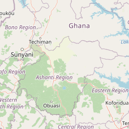
Map view of Mamiri Forest Reserve

Use this park location map to pinpoint Mamiri Forest Reserve in Ghana, understand its exact geographic position, and read its mapped placement within the surrounding landscape more clearly.

Pigeon | © OpenStreetMap contributors

Location context for Mamiri Forest Reserve

Western Region
Park atlas

Compare adjacent forest reserves and regional wildlife habitats across the Western Region

Explore Parks Near Mamiri Forest Reserve and Surrounding Protected Landscapes

Browsing other protected areas near Mamiri Forest Reserve reveals the broader ecological patterns of the Upper Guinea forest zone. Comparing these adjacent reserves provides essential regional context for understanding lowland tropical habitats and valley systems.
Nature reserveWestern North Region
About 34 km away#1 closest

Southwest

Boin Tano Forest Reserve: Mapping Ghana's Protected Tropical Nature Reserve Landscapes

Regional geography and habitat analysis in Western North Region

Boin Tano Forest Reserve stands as a vital protected area in Ghana, recognized for its complex mosaic of equatorial forest, grassland, and shrubland. This 129 square kilometre reserve serves as a sanctuary for diverse primate, antelope, and bird populations, reflecting the rich biodiversity of the Upper Guinean forest ecosystem within the Western North Region.

Area
129 km²
Established
1968
IUCN
V
Relief
Lowland
National parkGhana
About 48 km away#2 closest

Southwest

Nini-Suhien National Park: Protected Coastal Forest Geography and Mapping in Ghana

Regional forest landscapes and conservation boundaries

Nini-Suhien National Park serves as a vital anchor for coastal forest conservation in southwestern Ghana. This profile provides an atlas-level understanding of the park's location, its physical landscape features, and its role within the larger Ankasa Conservation Area for researchers and geography enthusiasts.

Area
160 km²
Established
1976
IUCN
II
Relief
Lowland
National parkGhana
About 48 km away#3 closest

Southwest

Nini-Suhien National Park: Geographic Atlas and Protected Area Boundary Mapping

Regional landscape context and protected terrain in Ghana.

Nini-Suhien National Park serves as a crucial protected area within the geography of Ghana. This entry provides structured information regarding the park boundaries and regional landscape characteristics, facilitating a deeper understanding of its place in the broader West African natural landscape and mapping framework.

IUCN
II
National parkWestern North Region
About 93 km away#4 closest

Northwest

Bia National Park: Ghana's Vital Protected Forest Landscape with West Africa's Tallest Trees

Explore the unique mapped geography and biodiversity of this key conservation area.

Bia National Park serves as a crucial protected landscape in Ghana's Western North Region, celebrated for harboring some of West Africa's tallest trees and a rich diversity of wildlife. This detailed entry provides context on its mapped boundaries and ecological significance as one of the last relatively untouched forest remnants in the region. Understand the park's place within Ghana's geography and its value for conservation research, showcasing its unique transitional forest ecosystem and the documented species it protects.

Area
563 km²
Established
1974
IUCN
II
Climate
Tropical
National parkGhana
About 97 km away#5 closest

East

Kakum National Park: Ghana's Landmark Protected Rainforest and Canopy Walkway

Mapped tropical forest landscape and unique elevated park exploration.

Kakum National Park represents a significant protected area within Ghana, characterized by its 375 square kilometers of moist evergreen tropical rainforest. The park's identity is strongly linked to its iconic canopy walkway, an engineering feat offering elevated views into the forest structure. As a national park, Kakum provides crucial mapped context for understanding West African biodiversity and regional geography, including notable primate populations and the densest concentration of forest elephants in Ghana. Its community-driven establishment also marks it as a key site for participatory conservation examples.

Area
375 km²
Established
1992
IUCN
II
Visitors
135.9K annual
Watercolor illustration of a tropical lagoon scene with palm trees on the banks, calm water, and a distant, hazy shoreline.
National parkComoé District
About 108 km away#6 closest

Southwest

Parc national des îles Ehotilé: Geography and Protected Landscapes of the Aby Lagoon Archipelago

Coastal national park featuring unique estuarine terrain and mangrove ecosystems.

Parc national des îles Ehotilé preserves a rare six-island archipelago within the Aby lagoon. The area showcases diverse aquatic environments, including salt-tolerant mangrove forests and dense woodland habitats that support large fruit bat colonies and West African manatee populations. This protected landscape represents a critical estuarine intersection in southeastern Cote d'Ivoire, offering deep insight into the region's complex hydrological and botanical geography.

Area
105 km²
Established
1974
IUCN
II
National parkIvory Coast
About 109 km away#7 closest

Southwest

Îles Ehotilé National Park: A Protected Island Ecosystem within Ivory Coast's National Park Network

Explore its island terrain and mapped coastal geography.

Îles Ehotilé National Park stands as a protected island ecosystem within the national park system of Ivory Coast. This area is distinguished by its island landscapes, coastal zones, and the surrounding marine environments characteristic of the Gulf of Guinea. As a designated national park, it plays a crucial role in preserving unique West African island biodiversity and providing a mapped protected area for ecological study and appreciation. The park's conservation focus highlights the importance of safeguarding coastal habitats within the region.

Area
105 km²
Established
1974
IUCN
II
Relief
Lowland
Wildlife reserveAshanti Region
About 161 km away#8 closest

Northeast

Bobiri Forest Reserve and Butterfly Sanctuary: Mapped Wildlife Reserve and Forest Geography

Ashanti Region protected landscape and butterfly habitat

Focusing on its status as a dedicated butterfly sanctuary, this protected forest reserve in Ghana offers a clear window into semi-deciduous ecology. Covering 54 square kilometers, the site is recognized for high insect biodiversity and its unique position as both an active research area and a managed wildlife reserve near the village of Kubease.

Area
54.65 km²
Established
1939
Relief
Upland
Climate
Tropical

Common questions about visiting, size, designation, and location context for Mamiri Forest Reserve

Mamiri Forest Reserve FAQs for park facts, access, geography, and protected area context

Find quick answers about Mamiri Forest Reserve, including protected-area facts, park geography, trail and visitor context, and how the park fits into its surrounding country and regional landscape.
MoriAtlas Explorer

Continue Your Protected Areas Search Across the Global Atlas

Deepen your exploration by continuing the structured search for national parks and protected areas worldwide. Utilize the comprehensive filtering capabilities to compare different conservation landscapes and refine your understanding of global park geography. Discover more about the distribution and characteristics of protected natural areas.

Global natural geography
