

Mori Atlas logo
Wildlife reserveRéserve spéciale de Mangerivola

Analyzing the rugged humid forest terrain and isolated ecological boundaries of this remote Malagasy sanctuary

Réserve spéciale de Mangerivola: An Essential Wildlife Reserve within the Atsinanana Protected Landscape Corridor

The Réserve spéciale de Mangerivola represents a vital protected corridor within the Atsinanana region of eastern Madagascar. This mapping of the reserve highlights its complex topography, which transitions from lowland dense humid forest to mid-altitude environments characterized by rocky outcrops and distinct rupicolous vegetation. By anchoring the reserve within the broader conservation network of the eastern coast, this data offers a clear view of its remote geography and significant role in shielding fragile interior forest ecosystems.

lowland rainforesthumid forestlemursindriaye-ayebirdwatching

Réserve spéciale de Mangerivola

Wildlife reserve

Park overview

Structured park overview, official facts, and landscape profile for Mangerivola Special Reserve

Mangerivola Special Reserve park facts, protected area profile, and essential visitor context

Review the core facts for Mangerivola Special Reserve, including designation, size, terrain, visitor scale, habitats, and operating context in one park-focused overview.

About Mangerivola Special Reserve

The Mangerivola Special Reserve protects a stretch of humid forest in one of the more remote corners of eastern Madagascar. Set inland from the coast in the Atsinanana region, the reserve sits within a larger landscape of protected forest that includes the Zahamena Strict Nature Reserve to which it is administratively connected. Its isolation, with no road reaching the reserve itself, has helped preserve a relatively undisturbed environment, though it also limits visitor access to determined naturalists and researchers.

The vegetation is dominated by lowland and mid-altitude humid dense forest, a formation characteristic of the eastern moist bioclimatic zone of Madagascar. Rocky habitats add an extra ecological layer in the form of rupicolous vegetation, supporting species and microhabitats distinct from the surrounding closed-canopy forest. This mosaic of dense forest and rock-outcrop communities creates conditions for high biodiversity in a comparatively limited area.

Wildlife is the defining feature of Mangerivola. The reserve is known to host seven lemur species, among them the indri, which is among the most iconic and acoustically distinctive primates in Madagascar, as well as sifakas, the ruffed lemur, the brown lemur, the red-bellied lemur, the grey bamboo lemur, and the aye-aye. The bird fauna is also significant, with around one hundred recorded species including the Soumagne's owl, one of the rarest owls in the world, and the rarely observed Madagascar serpent eagle. Reptile diversity is similarly notable, with nineteen recorded species. The reserve's combination of accessibility constraints and biological richness places it among the most scientifically valuable, if not the most visited, of Madagascar's eastern protected areas.

Quick facts and research context for Mangerivola Special Reserve

The Mangerivola Special Reserve was created in October 1958 under Madagascar's founding protected-area decree (decree 58-10). It is classified as a Special Reserve (IUCN Category IV) and managed by Madagascar National Parks. The reserve covers around one hundred thirty square kilometers of eastern Malagasy rainforest. It lies in the Atsinanana region, within the district of Brickaville, and is administratively linked to the Zahamena Strict Nature Reserve.

Protection and recognition

Documented terrestrial protection scope, management framework, and conservation registry details

Réserve spéciale de Mangerivola Protection Status and International Recognition

Terrestrial protection status records for Réserve spéciale de Mangerivola outline the documented management scope and conservation designation history. Structured administrative facts provide clear reference data for professional conservation tracking and protected area research.

Protection details

Protection scope
Terrestrial
Transboundary protection
No
Park context

Deeper park guide and search-rich context for Mangerivola Special Reserve

Mangerivola Special Reserve history, landscape, wildlife, and travel context

Explore Mangerivola Special Reserve through its history, landscape character, ecosystems, wildlife, conservation priorities, cultural context, and seasonal travel timing in a structured park guide built for atlas discovery and search intent.

Why Mangerivola Special Reserve stands out

Mangerivola is best known for its exceptionally rich assemblage of lemurs within a relatively compact rainforest block, including the indri, sifaka, ruffed lemur, brown lemur, red-bellied lemur, grey bamboo lemur, and aye-aye. It is also recognized as an important refuge for rare forest birds, particularly the Soumagne's owl and the Madagascar serpent eagle. The combination of lowland and mid-altitude humid forest with rupicolous vegetation gives the reserve a layered ecological character.

Mangerivola Special Reserve history and protected-area timeline

The Mangerivola Special Reserve was established on 28 October 1958 under decree 58-10, one of the foundational instruments that shaped Madagascar's modern protected-area network. From its creation, it was integrated into the national system of strict nature reserves, national parks, and special reserves that together protect representative samples of the country's ecosystems. The reserve has since been managed under the Madagascar National Parks umbrella, the public institution responsible for the country's network of national parks and reserves. Its administrative link to the Zahamena Strict Nature Reserve reflects an effort to manage connected forest landscapes as coherent ecological units rather than as isolated fragments.

Mangerivola Special Reserve landscape and geographic character

The landscape of Mangerivola is defined by the rugged relief of eastern Madagascar inland of the central-eastern coast. The reserve lies in a region with poor road access, contributing to a sense of remoteness and continuity with surrounding forest landscapes. The terrain supports both lowland dense humid forest on more accessible slopes and mid-altitude humid forest on elevated ground. Rocky outcrops scattered through the forest give rise to rupicolous vegetation, a visible physical and ecological signature of the reserve. Because much of the reserve must be reached on foot from the nearest roadhead at Anjahamana, the landscape retains an unbroken forest character between the approach trail and the interior.

Mangerivola Special Reserve ecosystems, habitats, and plant life

Ecologically, the Mangerivola Special Reserve belongs to the eastern humid bioclimatic zone of Madagascar, one of the wettest and most biologically productive biomes on the island. The reserve's vegetation is dominated by humid dense forest at low and mid elevations, with rupicolous plant communities occupying rock faces and shallow-soil rocky habitats. This combination produces a habitat mosaic typical of the eastern escarpment, where continuous forest cover is interrupted by geological exposures. The reserve's ecological value lies in the persistence of this forest mosaic under a strict-protection regime, allowing natural successional and disturbance processes to unfold with limited human interference.

Mangerivola Special Reserve wildlife and species highlights

Mangerivola is a significant site for Malagasy primate conservation, supporting seven lemur species within a relatively small area. These include the indri, the diademed sifaka and other Propithecus sifakas, the black-and-white ruffed lemur, the brown lemur, the red-bellied lemur, the grey bamboo lemur, and the aye-aye. Such a concentration of lemur species in a single reserve is ecologically important given that most Malagasy lemurs are restricted to shrinking eastern rainforest fragments.

The reserve's birdlife adds further weight to its conservation profile. Roughly one hundred bird species have been recorded, including the Soumagne's owl, one of the rarest owls in the world and a species of major international conservation concern, and the Madagascar serpent eagle, a rare forest-dwelling raptor. Reptile diversity is also notable, with nineteen recorded reptile species. Together, these groups give Mangerivola a varied and strictly forest-dependent fauna, with limited tolerance for habitat conversion.

Mangerivola Special Reserve conservation status and protection priorities

As a Special Reserve classified under IUCN Category IV, Mangerivola receives a protection regime focused on the conservation of specific habitats and species through managed intervention. It is part of the network originally established by decree 58-10 of 28 October 1958, which laid the foundation for Madagascar's protected-area system. Today the reserve is administered by Madagascar National Parks, the public body responsible for managing the country's national parks and special reserves.

Its administrative inclusion within the Zahamena Strict Nature Reserve network gives Mangerivola a broader conservation role, functioning as a buffer or complementary block within a larger landscape of strict protection. This integration is particularly important for wide-ranging forest species such as the indri and the Soumagne's owl, which depend on large, contiguous forest tracts. The reserve's isolation and restricted access further support its conservation role, providing a relatively undisturbed refuge in a region under significant land-use pressure.

Top sights and standout views in Mangerivola Special Reserve

Mangerivola's strongest highlights are ecological rather than infrastructural. The reserve is notable for supporting seven lemur species, including the indri, sifaka, ruffed lemur, red-bellied lemur, grey bamboo lemur, and aye-aye, all within a relatively compact forest block. It is also an important site for rare forest raptors and owls, particularly the Soumagne's owl and the Madagascar serpent eagle. Its integration with the Zahamena Strict Nature Reserve adds landscape-level significance, linking Mangerivola to a wider eastern Malagasy forest conservation corridor.
Monthly climate preview

Long-term monthly temperature and precipitation patterns recorded at representative park coordinates

Réserve spéciale de Mangerivola Climate Normals, Annual Temperature and Precipitation Rhythm

Representative coordinate measurements reveal distinct annual temperature and precipitation variations across the protected landscape from nineteen ninety-one to twenty twenty. Examining the complete monthly climate normals provides detailed monthly metrics for average temperatures and precipitation depths at this elevation.
Annual mean19 °C
15 °C22 °C
Jan22°
Feb22°
Mar21°
Apr20°
May19°
Jun16°
Jul15°
Aug16°
Sep17°
Oct19°
Nov20°
Dec22°
Warmest month
January

21.8 °C

Coolest month
July

15.4 °C

Wettest month
February

11.7 mm/day

Driest month
September

1.6 mm/day

Park location guide

Geography guide, regional context, and park location map for Mangerivola Special Reserve

Mangerivola Special Reserve park geography, regions, and map view in Madagascar

Understand where Mangerivola Special Reserve sits in Madagascar through a broader geographic reading of the surrounding landscape, nearby location context, and its mapped position within the national park landscape.

How Mangerivola Special Reserve fits into Madagascar

Madagascar is an island nation in the Indian Ocean, positioned off the southeastern coast of Africa. As the world's fourth-largest island and second-largest island country, it stands out for its exceptional biodiversity, over 90% of its wildlife is endemic, making it one of 17 megadiverse countries. The population is approximately 32 million, with Antananarivo as both the capital and largest city.

Wider geography shaping Mangerivola Special Reserve in Madagascar

Madagascar lies in the Indian Ocean off the southeastern coast of Africa, separated from the mainland by the Mozambique Channel. The island is situated approximately 400 km from the African continent. As the world's fourth-largest island, it also includes numerous smaller peripheral islands.

Map view of Mangerivola Special Reserve

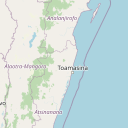
Use this park location map to pinpoint Mangerivola Special Reserve in Madagascar, understand its exact geographic position, and read its mapped placement within the surrounding landscape more clearly.

Pigeon | © OpenStreetMap contributors

Location context for Mangerivola Special Reserve

Atsinanana
Park atlas

Compare adjacent rainforest reserves and regional conservation corridors in eastern Madagascar.

Parks Near Réserve spéciale de Mangerivola and Surrounding Protected Landscapes

Browse protected areas near Réserve spéciale de Mangerivola to examine contiguous humid forest corridors and rugged highland terrain. Comparing adjacent reserves reveals broader ecological patterns across the eastern Malagasy rainforest network.
Nature reserveAnalanjirofo
About 48 km away#1 closest

Northeast

Réserve naturelle intégrale de Betampona: Atlas and Geographic Protected Area Profile

A vital lowland humid forest enclave in Analanjirofo

Delve into the mapped terrain of Réserve naturelle intégrale de Betampona, an integral nature reserve established in 1927 that protects a critical lowland humid evergreen forest fragment. The landscape is defined by its steep ridges and rapid stream networks, providing essential refuge for endemic lemurs and diverse plant life. This profile offers a clear view of the reserve's geographic setting and its status as a key conservation anchor for the eastern coastal ecosystems of Madagascar.

Area
29.18 km²
Established
1927
IUCN
Ia
Relief
Mountain
National parkMadagascar
About 49 km away#2 closest

North

Zahamena National Park: Madagascar National Park Exploration and Geographic Context

Mapping the protected boundaries and landscape of Zahamena National Park.

Delve into Zahamena National Park, a vital protected territory situated in Madagascar. This national park offers a unique perspective on the island's natural geography and its status as a significant protected landscape. Understand its position within Madagascar's broader context, focusing on the mapped aspects of its protected area identity and its contribution to the country's renowned biodiversity hotspot status.

Area
423 km²
Established
1997
IUCN
II
Relief
Mountain
Nature reserveAlaotra-Mangoro
About 58 km away#3 closest

North

Ankeniheny-Zahamena Corridor: Nature Reserve Landscape and Regional Geography

Mapping the central rainforest belt of the Alaotra-Mangoro region

Spanning over 3,800 square kilometers, the Ankeniheny-Zahamena Corridor stands as a cornerstone of Malagasy conservation. This reserve integrates diverse humid forest habitats into a single functioning landscape, providing a critical haven for endemic flora and threatened primates. Its role as a major watershed catchment reinforces its environmental importance for surrounding communities across eastern and western Madagascar.

Area
3,810 km²
Established
2007
IUCN
VI
Relief
Mixed relief
Protected landscapeAlaotra-Mangoro
About 89 km away#4 closest

Northwest

Lake Alaotra Protected Landscape: Atlas and Geographic Wetland Profile

Mapping the primary wetland basin of Madagascar's Alaotra-Mangoro region.

Lake Alaotra serves as a central protected landscape within the Alaotra-Mangoro region, featuring an extensive system of marshes, reedbeds, and freshwater zones. This profile offers a structured look at the lake's geography, its role as a critical wetland habitat, and the surrounding terrain that shapes this important Madagascar catchment area.

Area
7,223 km²
Relief
Lowland
Scope
Terrestrial
Water
Water-dominated
Watercolor illustration of a landscape featuring mountains, a lake, trees, and pink flowers in the foreground
National parkAlaotra-Mangoro
About 96 km away#5 closest

Southwest

Analamazaotra National Park: Protected Rainforest Ecosystem and Mapped Landscape in Alaotra-Mangoro

Explore Madagascar's Eastern Highlands protected area geography.

Analamazaotra National Park, situated in Madagascar's Alaotra-Mangoro region, represents a critical segment of the island's protected eastern rainforests. This national park is mapped as a vital conservation area, offering insights into its unique ecosystems and natural terrain. Understanding Analamazaotra National Park's geographic placement and protected boundaries provides essential context for regional landscape exploration and atlas-based geographic discovery within Madagascar.

Area
26.53 km²
Established
2015
IUCN
II
Relief
Highland
National parkAlaotra-Mangoro
About 97 km away#6 closest

Southwest

Andasibe-Mantadia National Park: National Park and Protected Landscape Identity

Explore its mapped boundaries and geographic context.

Andasibe-Mantadia National Park is a distinct protected territory within the Alaotra-Mangoro region, serving as a crucial focal point for understanding Madagascar's regional geography and protected land distribution. This detail page provides essential atlas-style information on the park's mapped area and its natural landscape characteristics. Engage with structured data that highlights the park's protected status and its position within the broader geographic framework of eastern Madagascar, supporting focused discovery for researchers and explorers.

Area
155 km²
Established
1989
IUCN
II
Visitors
26.1K annual
National parkMadagascar
About 97 km away#7 closest

Southwest

Mantadia National Park: Madagascar National Park and Protected Landscape Atlas

Mapped boundaries and regional geographic context of Mantadia.

Mantadia National Park represents a crucial protected landscape within Madagascar, detailed here for comprehensive geographic and atlas exploration. This entry focuses on its identity as a national park, providing insights into its mapped boundaries and its contribution to the understanding of Madagascar's diverse natural terrain. The information facilitates a structured discovery of the park's environmental and geographical significance, essential for anyone mapping protected areas.

Wildlife reserveAlaotra-Mangoro
About 98 km away#8 closest

Southwest

Analamazaotra Forest Station: Protected Rainforest Landscapes in Alaotra-Mangoro, Madagascar

Community-managed wildlife reserve and humid forest habitat

Analamazaotra Forest Station represents a core protected area within the humid eastern rain forests of Madagascar. Managed through local partnership, the reserve functions as a hub for habitat restoration and biodiversity conservation. This site is integral to the regional landscape, preserving a continuous block of essential forest habitat along the eastern escarpment that supports a wide range of endemic species.

Area
7.1 km²
Relief
Upland
Climate
Tropical
Access
Access unknown

Common questions about visiting, size, designation, and location context for Mangerivola Special Reserve

Mangerivola Special Reserve FAQs for park facts, access, geography, and protected area context

Find quick answers about Mangerivola Special Reserve, including protected-area facts, park geography, trail and visitor context, and how the park fits into its surrounding country and regional landscape.
MoriAtlas Explorer

Continue Your Protected Areas Search Across the Global Atlas

Deepen your exploration by continuing the structured search for national parks and protected areas worldwide. Utilize the comprehensive filtering capabilities to compare different conservation landscapes and refine your understanding of global park geography. Discover more about the distribution and characteristics of protected natural areas.

Global natural geography