Mori Atlas logo
Nature reserveMartlesham Wilds

Understanding the geography of a major lowland rewilding project along the River Deben estuary

Martlesham Wilds Nature Reserve: A Mapped Analysis of Suffolk Wetland Landscapes and Boundaries

Martlesham Wilds occupies 117 hectares of low-lying terrain on the banks of the River Deben in Suffolk, England. This nature reserve serves as an ambitious rewilding project, transforming former organic arable land into a complex mosaic of freshwater wetlands, tidal salt marshes, and ancient woodland. By integrating diverse habitats through a continuous green corridor, the site forms a critical link within the broader Deben Estuary ecological network, offering vital space for waterbirds and varied coastal wildlife.

nature reserverewildingwetlandsalt marshestuaryriver corridor

Martlesham Wilds

Nature reserve

Park overview

Structured park overview, official facts, and landscape profile for Martlesham Wilds

Martlesham Wilds park facts, protected area profile, and essential visitor context

Review the core facts for Martlesham Wilds, including designation, size, terrain, visitor scale, habitats, and operating context in one park-focused overview.

About Martlesham Wilds

Martlesham Wilds is a 117 hectare rewilding nature reserve owned and managed by the Suffolk Wildlife Trust, located on the banks of the River Deben just outside the village of Martlesham in Suffolk, England. The reserve was purchased in September 2023 from a former organic arable farm, with funding support from a Biffa Award grant alongside public donations. Its purpose is to step back from intensive agricultural management and allow ecological processes to shape the landscape over time.

The site occupies a strategically important position on the edge of the Deben Estuary Site of Special Scientific Interest and carries its own Ramsar designation, placing it within a network of nationally and internationally recognised wetland habitats. The Deben itself runs through the wider landscape, and the reserve is conceived as a key link in a green corridor that ties together ancient woodland, scrub, grassland, and tidal marsh along the river valley.

Rather than a finished, mature reserve, Martlesham Wilds is best understood as an active restoration landscape. Ponds are being restored and newly created, wetland scrapes and lagoons are being shaped into the low-lying ground, and new salt marsh is planned along the estuarine edge. Grazing animals are to be introduced to help maintain open habitat structure, and surveying platforms are being installed so that volunteers and visitors can observe ecological recovery as it unfolds.

The vision articulated by the Suffolk Wildlife Trust is that, by removing the constraints of arable farming and reintroducing natural processes, the reserve can develop into an intricate mosaic of habitats over time. The expectation is that this mosaic will support breeding and wintering birds such as avocets, curlews, and redshanks, alongside invertebrates, reptiles, and a range of mammals, turning a former farm into a living extension of the Deben estuary's ecological influence.

Quick facts and research context for Martlesham Wilds

Martlesham Wilds is a Suffolk Wildlife Trust nature reserve covering 117 hectares (290 acres) near Martlesham in Suffolk. It lies on the banks of the River Deben, adjacent to the Deben Estuary Site of Special Scientific Interest, and is itself recognised as a Ramsar site. The site was acquired in September 2023 from a former organic arable farm and is being developed as a rewilding area, with restored ponds, new scrapes and lagoons, and planned salt marsh creation. Grazing animals are to be introduced, and the reserve is intended to act as a green corridor connecting ancient woodland, scrub, grassland, and salt marsh along the Deben valley.

Protection and recognition

Examine documented protection metrics and official designation data

Martlesham Wilds Protection Status and Terrestrial Conservation Scope

Martlesham Wilds maintains a recorded terrestrial protection scope within the regional conservation network. Review structured management details and official international recognition records associated with the protected area.

Protection details

Protection scope
Terrestrial
Transboundary protection
No
Park context

Deeper park guide and search-rich context for Martlesham Wilds

Martlesham Wilds history, landscape, wildlife, and travel context

Explore Martlesham Wilds through its history, landscape character, ecosystems, wildlife, conservation priorities, cultural context, and seasonal travel timing in a structured park guide built for atlas discovery and search intent.

Why Martlesham Wilds stands out

Martlesham Wilds is best known as a large-scale lowland rewilding project on the edge of a Suffolk estuary. The reserve stands out for its ambition to convert former organic farmland into a connected mosaic of freshwater wetland, tidal salt marsh, scrub, and ancient woodland, all linked by the River Deben. It is also recognised for the wildlife expected to benefit from this restoration. The planned wetland habitat is intended to support avocets, curlews, and redshanks, as well as invertebrates, reptiles, and mammals. Together with its Ramsar designation and its position beside the Deben Estuary SSSI, this wildlife focus gives the site a clear ecological identity from its earliest stages of recovery.

Martlesham Wilds history and protected-area timeline

Martlesham Wilds has a short but distinctive recent history. Before its acquisition, the land was an organic arable farm, meaning that although it avoided synthetic chemicals, it remained under active cultivation rather than being managed primarily for wildlife.

In April 2023, the Suffolk Wildlife Trust announced plans to purchase the site as a rewilding project. The Trust's director of wildlife, conservation and recovery, Ben McFarland, framed the project as an opportunity to step back and allow natural processes to guide the recovery of the land into a richer habitat over time.

The purchase was completed in September 2023, supported by a grant from the Biffa Award together with donations. Since then the land has been transitioned from farmland to a developing nature reserve, marking the beginning of its rewilding phase and its formal entry into the network of Suffolk Wildlife Trust reserves.

Martlesham Wilds landscape and geographic character

Martlesham Wilds occupies 117 hectares of lowland terrain on the banks of the River Deben in Suffolk. The site lies on the western edge of the Deben Estuary, where tidal influence extends inland and gives the lower ground a brackish, estuarine character. Its elevation is low, and much of the reserve is shaped by the gentle topography typical of East Anglian river valleys.

The pre-purchase landscape was dominated by open arable fields. Since acquisition, the Trust has been reshaping the physical ground by restoring existing ponds, creating new ponds, and excavating wetland scrapes and lagoons that will hold water at varying levels throughout the year. New salt marsh is also planned along the estuary-facing edge of the reserve.

In its wider context, Martlesham Wilds sits within a landscape that includes ancient woodland, scrub, grassland, and the tidal habitats of the Deben Estuary. The river itself acts as a natural thread linking these different environments, and the reserve is intended to extend and connect them into a more continuous ecological corridor.

Martlesham Wilds ecosystems, habitats, and plant life

The ecological character of Martlesham Wilds is being deliberately constructed through rewilding rather than inherited from a pre-existing natural state. The aim is to grow a mosaic of habitats that reflects the estuary-edge position of the land and the influence of the River Deben.

Freshwater wetland is central to this mosaic. Restored and newly created ponds, together with shallow scrapes and lagoons, are intended to provide standing water across much of the year, supporting aquatic plants, invertebrates, and the animals that depend on them. Tidal influence from the Deben is expected to extend into the new salt marsh along the estuary edge, adding a brackish and intertidal dimension to the reserve.

Beyond wetland, the Trust envisions habitats ranging from open grassland maintained by grazing animals to scrub and reeds, with ancient woodland nearby providing a wooded counterpoint. The overall ecological intent is to create a gradient from freshwater wetland through brackish marsh into fully tidal estuary, generating a layered habitat structure that can support a wide community of species.

Martlesham Wilds wildlife and species highlights

Because Martlesham Wilds is a young rewilding site, much of its wildlife interest is projected rather than fully established. The Suffolk Wildlife Trust expects the restored freshwater wetlands, scrapes, and new salt marsh to attract a range of birds typical of the Deben Estuary, including avocets, curlews, and redshanks, which favour shallow, open water and tidal flats.

The habitat mosaic is also intended to support invertebrates and reptiles, which benefit from the combination of warm, open ground, standing water, and transition zones between freshwater and brackish conditions. Grazing animals, which the Trust plans to introduce, will help maintain open habitat structure for these groups.

Larger mammals are expected to make use of the reserve as it matures, taking advantage of the developing scrub and grassland cover and the connectivity that the green corridor will provide. Across these groups, the wildlife vision is for a site that functions as an extension of the estuary's ecological influence inland, rather than a stand-alone patch of habitat.

Martlesham Wilds conservation status and protection priorities

Martlesham Wilds is significant from a conservation perspective both for its designations and for the restoration approach being applied to it. The reserve itself is a Ramsar site, recognising it as a wetland of international importance, and it sits directly adjacent to the Deben Estuary Site of Special Scientific Interest, which highlights the wider importance of the river's tidal habitats for wildlife.

The conservation model is rewilding: rather than managing the land primarily for specific target species or habitats, the Trust is aiming to restore ecological processes such as natural water levels, grazing, and habitat succession. The conversion of a former organic arable farm into a recovering wetland and grassland landscape represents a meaningful shift in land use at a relatively large scale within lowland Suffolk.

By acting as a green corridor connecting ancient woodland, scrub, grassland, and salt marsh along the Deben valley, the reserve also has an important landscape-scale function. It increases the extent and connectivity of high-value habitats in a region where fragmentation has historically limited wildlife movement, and it provides a buffer of restored habitat next to one of Suffolk's most important estuarine systems.

Top sights and standout views in Martlesham Wilds

A 117 hectare Suffolk Wildlife Trust rewilding reserve on the River Deben, converted from former organic arable farmland after its 2023 purchase. The reserve carries both Ramsar and adjacent SSSI designations, reflecting the international and national importance of its wetland setting. Habitat restoration is centred on new ponds, wetland scrapes, lagoons, and planned salt marsh, with grazing animals to be introduced as part of the recovery process. The reserve is designed to link ancient woodland, scrub, grassland, and tidal marsh into a continuous green corridor along the Deben estuary. Wildlife priorities include avocets, curlews, and redshanks, alongside invertebrates, reptiles, and mammals able to use the developing mosaic of habitats.

Best time to visit Martlesham Wilds

As a young rewilding site still in active restoration, Martlesham Wilds is best understood as a landscape in transition rather than a fully formed reserve. Spring and summer tend to be the most rewarding periods for visiting similar Suffolk wetland sites, when water levels in scrapes and ponds are typically at their most attractive to breeding waders and when bird activity is highest. Autumn and winter can also offer interest, particularly as the reserve matures and tidal influences on the planned salt marsh become more established.

Visitors should bear in mind that habitat works, grazing introductions, and ecological recovery are ongoing, so the character of the site will continue to change from year to year. Conditions on the ground may also reflect the practical realities of a wetland landscape, with soft ground and water levels varying through the seasons.
Monthly climate preview

Long-term representative point measurements tracking monthly averages across Suffolk

Martlesham Wilds Climate Normals, Annual Temperature and Precipitation Rhythms

Martlesham Wilds records measured long-term monthly temperature and precipitation data based on historical coordinate climatology. Examining the full twelve-month statistical record provides detailed context for regional environmental patterns and annual weather variation.
Annual mean11 °C
5 °C17 °C
Jan
Feb
Mar
Apr
May12°
Jun15°
Jul17°
Aug17°
Sep15°
Oct12°
Nov
Dec
Warmest month
August

17.4 °C

Coolest month
February

4.7 °C

Wettest month
October

2.4 mm/day

Driest month
April

1.4 mm/day

Park location guide

Geography guide, regional context, and park location map for Martlesham Wilds

Martlesham Wilds park geography, regions, and map view in United Kingdom

Understand where Martlesham Wilds sits in United Kingdom through a broader geographic reading of the surrounding landscape, nearby location context, and its mapped position within the national park landscape.

How Martlesham Wilds fits into United Kingdom

The United Kingdom is a parliamentary constitutional monarchy located in northwestern Europe, consisting of four constituent countries: England, Scotland, Wales, and Northern Ireland. As a major global power with over 69 million residents, it maintains significant international influence in politics, economics, and culture.

Wider geography shaping Martlesham Wilds in United Kingdom

The United Kingdom is an island nation located in northwestern Europe, surrounded by the Atlantic Ocean, North Sea, English Channel, Celtic Sea, and Irish Sea. It shares a land border with the Republic of Ireland to the west. The territory includes the island of Great Britain, the northeastern portion of Ireland, and most of the smaller British Isles islands.

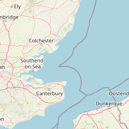
Map view of Martlesham Wilds

Use this park location map to pinpoint Martlesham Wilds in United Kingdom, understand its exact geographic position, and read its mapped placement within the surrounding landscape more clearly.

Pigeon | © OpenStreetMap contributors

Location context for Martlesham Wilds

Suffolk
Park atlas

Compare adjacent wetland reserves and regional conservation areas in eastern England.

Explore Parks Near Martlesham Wilds and Surrounding Protected Landscapes

Continue browsing other parks near Martlesham Wilds to examine connected estuarine habitats and lowland rewilding projects across the wider region. Comparing adjacent protected areas reveals broader geographic patterns in river valley conservation and wetland restoration.
Nature reserveEssex
About 32 km away#1 closest

Southwest

Colne Estuary Nature Reserve: Geography and Protected Landscapes of the Essex Coast

Coastal wetlands, saltmarsh zones, and geological formations

Colne Estuary represents a massive tidal landscape in Essex characterized by the interaction between fluvial and marine systems. Covering over 2,900 hectares, this site protects diverse habitats including intertidal mudflats, active saltmarshes, and transitional zones that support wintering waterbirds. The area remains a key reference for studying coastal accretion and Quaternary geology in the East of England.

Area
29.152 km²
Established
1989
Relief
Lowland
Climate
Temperate
A soft watercolor illustration showing rolling green hills and wetlands against a light, pale sky.
Nature reserveEssex
About 38 km away#2 closest

Southwest

Abberton Reservoir: Mapped Landscape and Protected Area Context in Essex, England

Freshwater reservoir, wetland, and historic site

Abberton Reservoir stands as a landmark of regional geography in Essex. This entry maps the site's transition from an engineered water-supply facility to a mosaic of reedbeds, marshes, and open water, providing essential habitat for migratory wildfowl and wintering bird populations.

Area
7 km²
Established
1939
Relief
Lowland
Climate
Temperate
Watercolor painting showing grassy wetlands and distant hills with a sunset sky
National parkUnited Kingdom
About 43 km away#3 closest

North

The Broads National Park: Wetland Landscape, Rivers, and Regional Geography Atlas

Explore mapped waterways and protected reedbed ecosystems.

The Broads National Park offers a singular protected wetland landscape with over 200 kilometers of navigable waterways across its numerous shallow lakes, or 'broads.' Shaped by medieval peat excavations and natural processes, this area presents a unique geography of reedbeds and grazing marshes, punctuated by historic windmills. Discover the mapped extent of this protected landscape, its river systems, and its vital role in regional geography through structured atlas data.

Area
303 km²
Established
1989
IUCN
V
Relief
Lowland
Marine protected areaEssex
About 46 km away#4 closest

Southwest

Blackwater, Crouch, Roach and Colne Estuaries Marine Conservation Zone Geography and Map

A comprehensive look at England's largest inshore marine protected area.

Covering 284 square kilometers of the Essex coast, this marine conservation zone integrates four tidal estuaries and North Sea coastal frontage into a single protected system. Recognized for its unique native oyster beds and vast intertidal mudflats, the area provides essential habitat for waterfowl. Explore the mapped terrain and overlapping conservation boundaries that define this vital estuarine landscape.

Area
284 km²
Relief
Lowland
Climate
Temperate
Scope
Marine
Marine protected areaNorfolk
About 98 km away#5 closest

North

Cromer Shoal Chalk Beds: A Major Marine Protected Area Off the Norfolk Coastline

Subtidal chalk reefs and biodiverse marine landscapes.

Spanning roughly 320 square kilometres of seabed, the Cromer Shoal Chalk Beds form a remarkable marine environment known for its massive chalk reef structures. This protected zone preserves a complex mosaic of marine life, including unique sponge species and diverse invertebrates that thrive on the rare hard chalk substrate found beneath the southern North Sea waters.

Area
321 km²
Established
2016
Relief
Lowland
Climate
Temperate
A horizontal watercolor painting showing a soft coastal scene with rolling dunes, sparse grasses, and a calm shoreline under a light sky.
Nature reservePas-de-Calais
About 129 km away#6 closest

Southeast

Réserve naturelle nationale du Platier d'Oye: Protected Coastal Landscape and Wetland Geography

Coastal dunes and migratory bird habitats in Pas-de-Calais

Located along the Opal Coast, the Réserve naturelle nationale du Platier d'Oye represents a complex mosaic of tidal flats, mobile sand dunes, and humid polder meadows. This protected area offers unique insight into the ecological intersection of maritime forces and terrestrial environments, functioning as a primary staging ground for diverse migratory species within the Hauts-de-France coastal region.

Area
3.91 km²
Established
1987
IUCN
IV
Relief
Lowland
Nature reserveHauts-de-France
About 135 km away#7 closest

Southeast

Réserve naturelle régionale de Grande-Synthe: Protected Geography and Regional Mapping

Nature reserve landscapes in the Hauts-de-France coastal plain

Spanning 174 hectares on the edge of the Dunkirk urban zone, this protected area serves as a model for ecological restoration. Examine the patchwork of sandy grasslands, wetlands, and mature hedgerows that define the reserve, and see its position as a link in the regional green and blue ecological corridor of northern France.

Area
1.74 km²
Established
2015
Relief
Lowland
Climate
Temperate
A horizontal watercolor painting showing a soft landscape with green vegetation, pink accents, and a winding body of water leading towards distant hills.
Nature reserveFrance
About 137 km away#8 closest

South

Réserve naturelle régionale du mont de Couple: Protected Chalk Escarpment and Coastal Viewpoint

A limestone ridge sanctuary in the northern French Boulonnais region

Spanning a rare chalk cuesta in northern France, this protected area balances ecological conservation with distinct geological features. The reserve provides critical habitat for orchids and protected flora while serving as a strategic viewpoint across the Straits of Dover and the surrounding Opal Coast terrain.

Area
0.136 km²
Established
1997
Relief
Upland
Climate
Temperate

Common questions about visiting, size, designation, and location context for Martlesham Wilds

Martlesham Wilds FAQs for park facts, access, geography, and protected area context

Find quick answers about Martlesham Wilds, including protected-area facts, park geography, trail and visitor context, and how the park fits into its surrounding country and regional landscape.
MoriAtlas Explorer

Continue Your Protected Areas Search Across the Global Atlas

Deepen your exploration by continuing the structured search for national parks and protected areas worldwide. Utilize the comprehensive filtering capabilities to compare different conservation landscapes and refine your understanding of global park geography. Discover more about the distribution and characteristics of protected natural areas.

Global natural geography