

Mori Atlas logo
Natural monumentMeandry Lučiny

A preserved lowland river corridor tracing natural meanders through the Moravian-Silesian industrial landscape

Meandry Lučiny Natural Monument: Protected Riverine Geography and Floodplain Landscape Maps

Meandry Lučiny represents a protected natural monument in the northeastern Czech Republic, safeguarding approximately 2.5 kilometers of the Lučina River as it carves through soft floodplain deposits. This site maintains an active, unregulated river course that sustains a complex mosaic of wet meadows, riparian forests, and shifting gravelly substrates. Located on the urban fringes of the Moravian-Silesian Region, the protected area functions as a critical ecological refuge where natural hydrological dynamics persist against a backdrop of regional industrialization.

river meandersfloodplain forestwet meadowswetlandsnatural monumentlowland river
A stylized, flat-design illustration of a river flowing through a lush green valley with trees and distant hills under a soft sky.

Meandry Lučiny

Natural monument

Park overview

Structured park overview, official facts, and landscape profile for Meandry Lučiny

Meandry Lučiny park facts, protected area profile, and essential visitor context

Review the core facts for Meandry Lučiny, including designation, size, terrain, visitor scale, habitats, and operating context in one park-focused overview.

About Meandry Lučiny

Meandry Lučiny sits on the outskirts of Havířov, a city in the industrial heart of northeastern Czechia, where rivers, forests, and industrial heritage meet. The protected area centers on a 2.5 kilometer stretch of the Lučina River where the watercourse has been allowed to follow its natural course through clay-rich floodplain sediments, forming a series of pronounced meanders. Because the river has not been straightened or reinforced here, it continues to shift laterally, eroding outer banks, building inner point bars, and occasionally cutting off meanders to form new wet depressions.

This natural dynamism is the defining ecological characteristic of the site. Each part of the river system supports a slightly different community of plants and animals. Steeper eroded banks host particular invertebrates and nesting birds; quieter marginal waters favor amphibians and dragonflies; and the floodplain forest and wet meadows that fringe the corridor provide habitat for woodland and meadow species alike. Together, the meander, the floodplain forest, the wet meadows, and the marshy floodplain depressions form an interconnected habitat complex that has been maintained as a natural monument since the early 1990s.

The wider context of Meandry Lučiny is unusual for a nature reserve. Rather than being embedded in an extensive natural landscape, the protected site lies within a densely populated, post-industrial region that has been heavily shaped by coal mining, steelmaking, and urbanization. The presence of a free-flowing, meandering river in this setting is what gives the site its particular value: it preserves a functional example of a lowland river ecosystem in a landscape where such conditions have become rare.

For visitors and locals alike, Meandry Lučiny functions as a green corridor threading through the edge of the city. Walking paths along the river offer close-up views of the meanders, muddy banks, and seasonal changes in water level, while the surrounding floodplain forest and meadows soften the transition between urban neighborhoods and the broader countryside of the Karviná district.

Quick facts and research context for Meandry Lučiny

Meandry Lučiny is a Czech natural monument (přírodní památka) located in the district of Karviná, within the Moravskosilesian Region, on the territory of the statutory city of Havířov. It lies near the boundary between the city districts of Havířov-Město and Bludovice, not far from the town center.

The site was declared protected by decree of the District Office in Karviná, effective from January 1, 1992, and covers roughly 40 hectares of river corridor, floodplain, and associated wet habitats. Its core feature is an unregulated stretch of the Lučina River, which meanders naturally through clay floodplain sediments and supports well-developed wetland, floodplain forest, and meadow communities characteristic of lowland river landscapes.

Protection and recognition

Documented terrestrial protection scope, designation year, and management context.

Meandry Lučiny Protection Status and Designated Area History

Meandry Lučiny maintains a documented terrestrial protection status established in 1991 for regional conservation management. Structured records compile the official designation history and management scope without additional international recognition sources.

Protection details

Protection scope
Terrestrial
Designated year
1991
Transboundary protection
No
Park context

Deeper park guide and search-rich context for Meandry Lučiny

Meandry Lučiny history, landscape, wildlife, and travel context

Explore Meandry Lučiny through its history, landscape character, ecosystems, wildlife, conservation priorities, cultural context, and seasonal travel timing in a structured park guide built for atlas discovery and search intent.

Why Meandry Lučiny stands out

Meandry Lučiny is best known for its naturally meandering stretch of the Lučina River, one of the few unregulated river sections remaining in this heavily urbanized and industrialized part of the Moravian-Silesian Region. The site protects not only the curving river channel itself but the entire ribbon of floodplain habitats that has developed along it. The dynamic character of the meandering river is the central feature of the site. As the river continuously reshapes its bed, it generates a constantly changing mosaic of pools, banks, gravelly and muddy substrates, oxbow-like cutoffs, and wet depressions. This hydrological activity creates conditions for a wide range of species, from spring geophytes in the floodplain forest to amphibians, dragonflies, and river birds along the open water. The protected area thereby illustrates how a small lowland river can maintain remarkable ecological complexity when its natural dynamics are preserved.
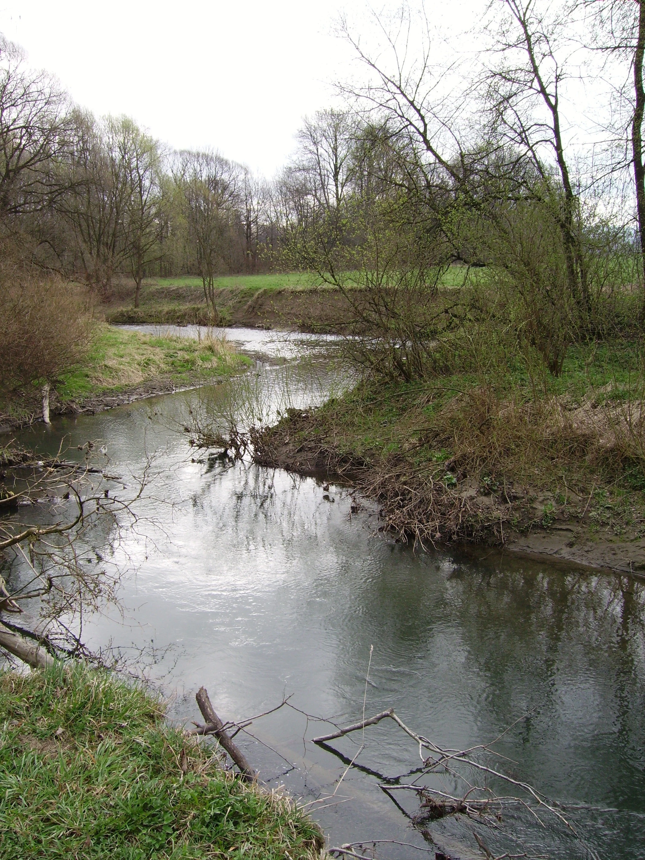
A calm, winding river flows through a grassy, wooded landscape under an overcast sky.
A winding section of the Lučina River within the protected area.

Meandry Lučiny history and protected-area timeline

Meandry Lučiny was declared a natural monument by decree of the District Office in Karviná on November 25, 1991, with the protection taking legal effect at the start of 1992. The designation responded to the recognition that, even amid a heavily urbanized and industrialized landscape, this stretch of the Lučina River retained a remarkably natural, free-flowing character.

The site's protected status has been grounded in two interconnected concerns. First, the unregulated river itself was seen as worthy of preservation because of its rare, dynamically shifting meander morphology within a region where most rivers had been altered. Second, the floodplain habitats associated with the meanders, including wetland vegetation, floodplain forest, and wet meadows, were recognized as ecologically valuable refuges of biodiversity that had survived alongside centuries of human settlement and industrial activity.

Since its designation, Meandry Lučiny has continued to function as a small but ecologically meaningful protected site within the broader system of Czech nature conservation. Its trajectory illustrates how targeted local protection can preserve ecologically important riverine features even where large-scale landscape transformation has already taken place.

Meandry Lučiny landscape and geographic character

The landscape of Meandry Lučiny is defined almost entirely by the river that gives the site its name. The Lučina River winds through clay floodplain deposits in a series of pronounced meanders, with the channel shifting laterally over time through erosion of outer banks and deposition of sediment on inner curves. This continuous reshaping produces a varied riverbed characterized by alternating deeper pools, shallower riffles, muddy and gravelly substrates, and abandoned or partially abandoned meander cutoffs.

Above the riverbanks, the terrain is gentle and flat, typical of a lowland river floodplain. The river corridor is bordered by a mosaic of habitats rather than a single uniform forest type. Directly along the watercourse stretches a narrow band of floodplain woodland, where trees and shrubs tolerant of periodic flooding dominate. Beyond the forest margins, the land opens into wet meadows and secondary grasslands that have developed in the broader floodplain.

The overall impression of the landscape is one of quiet, low-relief river scenery tucked against the edge of the city. There are no dramatic cliffs, mountain peaks, or expansive vistas; instead, the visual and ecological richness comes from the interplay of curving water, soft floodplain vegetation, and the shifting patterns of erosion and deposition that keep the scene constantly, if slowly, in motion.

Meandry Lučiny ecosystems, habitats, and plant life

The ecological character of Meandry Lučiny arises directly from the relationship between the meandering river and its floodplain. The active channel creates a continuously refreshed set of habitats: freshly eroded banks, recently deposited point bars, slow-moving marginal pools, and disconnected backwaters. Each of these microhabitats supports different groups of plants and animals, and their spatial arrangement changes as the river continues to reshape its course.

Surrounding the river corridor is a transition from aquatic and wetland habitats to terrestrial floodplain communities. The narrow belt of floodplain forest along the banks is composed of tree species adapted to occasional inundation, providing shade for the river and structural complexity along its edges. Outside the forest, wet meadows and marshy depressions extend across the broader floodplain, contributing additional layers of botanical diversity and offering habitat for amphibians and insects that depend on seasonally saturated ground.

The combination of running water, standing wet areas, floodplain woodland, and open meadow gives the site an unusually high habitat heterogeneity for its small size. It is precisely this heterogeneity, maintained by the unregulated river dynamics, that supports the rich mix of species documented for the area.

Meandry Lučiny wildlife and species highlights

Wildlife at Meandry Lučiny reflects the diversity of habitats arranged along and around the meandering river. Amphibians are among the most characteristic groups, with common toads, green toads, edible frogs, and smooth newts recorded in the wetter margins, pools, and meadows that flank the river.

The river itself and its banks host a range of aquatic and riparian invertebrates, including notable dragonflies such as the small red-eyed damselfly and the white-tailed skimmer, as well as fish species like the common minnow and the European brook lamprey, the latter being of particular conservation interest as an indicator of relatively clean, well-oxygenated water. The presence of the noble crayfish further underlines the ecological quality of the river habitat.

Birds are a particularly visible feature of the site. The riverbanks and adjacent vegetation provide habitat for the common kingfisher, the Eurasian wren, the little ringed plover along open gravelly shores, and the white-throated dipper, which depends on fast-flowing, oxygen-rich reaches of the river. Together, these species highlight the importance of the site for both aquatic and waterside wildlife within an urbanizing landscape.

Meandry Lučiny conservation status and protection priorities

Meandry Lučiny holds conservation significance primarily as a preserved example of a naturally meandering lowland river in a region where such conditions have become rare. By formally protecting the unregulated course of the Lučina River and its directly associated floodplain habitats, the site safeguards the physical processes that maintain the meander dynamics, along with the species and ecological communities those processes support.

Protection here is not aimed at preserving a static landscape but at maintaining an active hydrological and ecological system. Allowing the river to continue its natural lateral movement, erosion, and deposition is essential to the long-term conservation value of the site, because it is this very dynamism that generates habitat diversity. In this sense, Meandry Lučiny represents an ecologically meaningful counterpoint to the more heavily engineered river systems characteristic of much of the surrounding industrial landscape.

The site also contributes to broader conservation objectives by retaining populations of species that are sensitive to river regulation and habitat fragmentation, such as the European brook lamprey, the noble crayfish, and the common kingfisher. These species act as indicators of the river's ecological health and lend the site importance beyond its modest size.

Meandry Lučiny cultural meaning and human context

Meandry Lučiny sits at the cultural boundary between urban industrial life and the remnants of the natural river landscape of the Moravian-Silesian Region. The city of Havířov, which expanded significantly during the twentieth century as part of the industrial development linked to coal mining in the Karviná basin, is the immediate backdrop of the site. The protected meander stretch therefore carries cultural meaning as a surviving ribbon of older, pre-industrial landscape character within a city shaped largely by industry and planned urban growth.

For local communities, the meanders also function as a nearby natural space closely tied to the identity of the city's edge. The border between the districts of Havířov-Město and Bludovice, where the protected area lies, places the river corridor at the seam between older and newer parts of the city, integrating it into everyday local life as a place for walking, observing seasonal changes, and connecting with the region's river heritage.

Top sights and standout views in Meandry Lučiny

The defining highlight of Meandry Lučiny is the living, shifting geometry of the river itself: a 2.5 kilometer stretch of the Lučina still allowed to carve and abandon meanders through floodplain clay, rather than being straightened or reinforced.

Equally important is the surrounding floodplain habitat complex, where floodplain forest, wet meadows, and marshy depressions form a tightly woven ecological mosaic. This diversity, sustained by active hydrological processes, supports amphibians, dragonflies, river fish including the European brook lamprey, the noble crayfish, and characteristic river birds such as the common kingfisher and the white-throated dipper, all within a compact area on the edge of a major industrial city.

Best time to visit Meandry Lučiny

Meandry Lučiny can be visited throughout the year, with each season offering a different perspective on the river and its floodplain. Spring is particularly rewarding botanically, when characteristic floodplain forest geophytes such as the yellow wood anemone, yellow star-of-Bethlehem, and related spring-flowering species come into bloom beneath the still-bare trees along the riverbanks.

Late spring and early summer bring the most active amphibian, dragonfly, and bird activity along the margins of the river, meadows, and wet depressions, making this an appealing period for wildlife observation. Autumn highlights the colors of the floodplain forest and the migration of water-associated birds, while winter, with lower vegetation and exposed banks, makes the shape of the meanders especially easy to appreciate from surrounding paths.


Monthly climate preview

Long-term representative point measurements for annual weather patterns

Meandry Lučiny climate normals, measured monthly temperature and precipitation rhythm

Representative coordinates record sustained temperature shifts and monthly precipitation variations across the protected landscape. Full twelve-month climate normals provide detailed reference values for average daily highs, lows, and precipitation rates.
Annual mean8 °C
-3 °C20 °C
Jan-3°
Feb-2°
Mar
Apr
May14°
Jun17°
Jul20°
Aug19°
Sep14°
Oct
Nov
Dec-2°
Warmest month
July

19.7 °C

Coolest month
January

-3.3 °C

Wettest month
July

3.1 mm/day

Driest month
January

1.2 mm/day

Park location guide

Geography guide, regional context, and park location map for Meandry Lučiny

Meandry Lučiny park geography, regions, and map view in Czechia

Understand where Meandry Lučiny sits in Czechia through a broader geographic reading of the surrounding landscape, nearby location context, and its mapped position within the national park landscape.

How Meandry Lučiny fits into Czechia

Czech Republic is a landlocked Central European country with a population of approximately 10.9 million people. The nation was established as an independent state on January 1, 1993, following the dissolution of Czechoslovakia. Its capital and largest city is Prague, with other major urban centers including Brno, Ostrava, Plzeň, and Liberec.

Wider geography shaping Meandry Lučiny in Czechia

The Czech Republic is a landlocked country in Central Europe. It is bordered by Germany to the west, Austria to the south, Poland to the northeast, and Slovakia to the southeast. The landscape is predominantly hilly, with the territory covering 78,871 square kilometers.

Map view of Meandry Lučiny

Use this park location map to pinpoint Meandry Lučiny in Czechia, understand its exact geographic position, and read its mapped placement within the surrounding landscape more clearly.

Pigeon | © OpenStreetMap contributors

Location context for Meandry Lučiny

Moravskoslezský kraj

Explore natural monument imagery, wetland habitats, and protected lowland river terrain

Meandry Lučiny Photos and Scenery: Visualizing River Landscapes

Visual documentation captures the natural meanders, floodplain forests, and shifting river channels that define this protected lowland corridor. Examining these detailed field photographs reveals how the unregulated watercourse sustains diverse riparian habitats amid an industrial setting.

A calm, winding river flows through a grassy, wooded landscape under an overcast sky.

Park atlas

Compare nearby regional parks and connected riverine protected landscapes.

Other Parks Near Meandry Lučiny and Surrounding Protected Natural Areas

Browsing other parks near Meandry Lučiny reveals a broader network of protected natural areas across the surrounding Moravian-Silesian Region. Comparing these regional reserves offers valuable context on lowland river corridors and urban fringe conservation.
Natural monumentMoravskoslezský kraj
About 3.6 km away#1 closest

West

Václavovice, pískovna Natural Monument: Mapped Geography and Protected Wetland Boundaries

Amphibian habitat and industrial site reclamation in Moravskoslezský kraj

Václavovice, pískovna represents a carefully managed natural monument where former quarrying activities have evolved into a rich mosaic of ponds, reeds, and damp woodland. Situated in the Moravian-Silesian Region, this compact site provides essential shelter for multiple amphibian species and underscores the importance of secondary natural habitats within broader regional geography.

Area
0.069 km²
Established
2013
IUCN
III
Relief
Lowland
A soft watercolor illustration depicting a green, open floodplain with rows of trees under a pale, gentle sky.
Nature reserveMoravskoslezský kraj
About 16 km away#2 closest

West

Polanský les Nature Reserve: Mapped Protected Landscape and Floodplain Geography

A preserved hardwood forest relic in the Ostrava region

Polanský les maintains a critical status as a protected nature reserve, safeguarding a relic hardwood floodplain forest along the Oder River. This area is characterized by its significant botanical diversity, including established snowdrop populations and mature broadleaf woodland. Its location within the Moravskoslezský kraj highlights its role as a dense ecological fragment at the geological boundary between the Bohemian Massif and the Outer Western Carpathians.

Area
0.598 km²
Established
1970
IUCN
IV
Relief
Lowland
Natural monumentMoravskoslezský kraj
About 18 km away#3 closest

North

Věřňovice Natural Monument: Mapping Protected Floodplain Woodlands in the Moravian-Silesian Region

Geographic overview of the Olše river terrace habitat.

Located near the Czech-Polish border, Věřňovice serves as a vital protected natural monument featuring well-preserved floodplain forest communities. This compact site offers deep insights into river terrace geomorphology and local woodland distribution, characterized by a diverse mosaic of elm and oak-hornbeam stands that support distinct ecological communities.

Area
0.046 km²
Established
1989
IUCN
III
Relief
Lowland
Natural monumentMoravskoslezský kraj
About 23 km away#4 closest

South

Vodopády Satiny Natural Monument: Mapped Geography and Protected Carpathian Landscapes

Regional geomorphology in the Moravskoslezský kraj

The Vodopády Satiny natural monument protects one of the most clearly exposed rock channels in the Czech Carpathians. Located in the Moravskoslezský kraj, the site demonstrates the impact of flysch geology on stream formation, where cascading waters have carved a distinct, long-exposure path through local mountain forests.

Area
0.09 km²
Established
2006
IUCN
III
Relief
Mountain
A horizontal watercolor painting depicting soft, layered green hills and purple-toned mountain ridges in the distance, with a foreground of stylized evergreen trees.
Protected landscapeSilesian Voivodeship
About 25 km away#5 closest

East

Park Krajobrazowy Beskidu Śląskiego: Geographic Atlas of Protected Silesian Beskid Landscapes

Mapped mountain ridges, river headwaters, and protected forest reserves.

Gain insight into the ecological and structural character of Park Krajobrazowy Beskidu Śląskiego. This resource documents the park's flysch geological formations, rare cave systems, and the hydrological significance of the Vistula River headwaters within the Silesian Beskids.

Area
386.2 km²
Established
1998
Relief
Mountain
Climate
Alpine
Natural monumentMoravskoslezský kraj
About 30 km away#6 closest

Southwest

Váňův kámen: Natural Monument and Jurassic Limestone Landmark in the Moravian-Silesian Region

Geological outcrops and forest terrain in the Sub-Beskydy Hills

Váňův kámen presents a sharp, pyramid-shaped Jurassic limestone formation that breaks the rolling topography of the Sub-Beskydy Hills. This 0.78-hectare protected site preserves vital evidence of prehistoric coral reefs alongside significant archaeological layers and historical markers. Its unique position as a natural, historical, and geological feature makes it a focal point for understanding the diverse landscape composition of the Czech Moravian-Silesian Region.

Area
0.008 km²
Established
1993
IUCN
III
Relief
Upland
Nature reservePoland
About 31 km away#7 closest

East

Kościół w Górkach Wielkich: Nature Reserve and Protected Habitat in Silesian Voivodeship

Mapping cultural heritage and ecological sanctuary boundaries

Explore the geography of Kościół w Górkach Wielkich, a specialized Natura 2000 protected site situated within the Brenna commune. This entry provides context on the church architecture and the local protected terrain that creates a essential roost for regional bat populations in the Silesian Beskids foothills.

Relief
Lowland
Scope
Terrestrial
Water
Minor water
Nature reserveSilesian Voivodeship
About 32 km away#8 closest

East

Morzyk Nature Reserve: A Protected Forest Landscape in the Silesian Foothills of Southern Poland

Mapping forest communities and ravine terrain within the Silesian Voivodeship.

Morzyk Nature Reserve protects a rich mosaic of deciduous woodlands and beech-dominated stands in southern Poland. This compact forest reserve offers deep insight into the ecological character of the Silesian Foothills, featuring well-preserved ravines and old-growth trees that anchor the regional geography.

Area
0.103 km²
Established
1996
Relief
Upland
Climate
Temperate

Common questions about visiting, size, designation, and location context for Meandry Lučiny

Meandry Lučiny FAQs for park facts, access, geography, and protected area context

Find quick answers about Meandry Lučiny, including protected-area facts, park geography, trail and visitor context, and how the park fits into its surrounding country and regional landscape.
MoriAtlas Explorer

Continue Your Protected Areas Search Across the Global Atlas

Deepen your exploration by continuing the structured search for national parks and protected areas worldwide. Utilize the comprehensive filtering capabilities to compare different conservation landscapes and refine your understanding of global park geography. Discover more about the distribution and characteristics of protected natural areas.

Global natural geography