Mori Atlas logo
Nature reserveMergiškių gamtinis rezervatas

Geographic analysis of strictly protected woodland habitats in the Trakai District landscape

Mergiškių gamtinis rezervatas Protected Nature Reserve and Glacial Forest Landscapes

Mergiškių gamtinis rezervatas functions as a strictly protected woodland sanctuary situated within the hilly terrain of the Trakai District Municipality. This site safeguards rare hornbeam-dominated forest ecosystems that represent the ecological character of southeastern Lithuania. Through protected-area mapping and geographic analysis, the reserve serves as a vital refugium for diverse species listed in the Lithuanian Red Data Book, maintaining intact forest processes within the broader Aukštadvaris regional framework.

nature reservestrict protectionhornbearm forestbroadleaf forestforest conservationNatura 2000

Mergiškių gamtinis rezervatas

Nature reserve

Park overview

Structured park overview, official facts, and landscape profile for Mergiškių Nature Reserve

Mergiškių Nature Reserve park facts, protected area profile, and essential visitor context

Review the core facts for Mergiškių Nature Reserve, including designation, size, terrain, visitor scale, habitats, and operating context in one park-focused overview.

About Mergiškių Nature Reserve

Mergiškių Nature Reserve sits in the heart of the Aukštadvaris landscape, a region of forested hills, glacial lakes, and traditional rural land use that forms one of the most distinctive natural environments in southeastern Lithuania. Although the reserve itself is small in geographic terms, it occupies a central position within the broader Aukštadvaris Regional Park, a protected area created to manage the ecological, scenic, and recreational value of this corner of the country southwest of Vilnius. The reserve is administered as part of that regional system, but its management regime is far stricter than that of the surrounding parkland.

The defining feature of the site is its forest character. The reserve protects a portion of the Mergiškių hill forest, a woodland that climbs over a series of low hills typical of the Aukštadvaris area and that retains a notably natural structure compared to many of the more intensively managed woodlands elsewhere in Lithuania. Hornbeam is a particularly important component of this forest. Once more widespread across the region, mature hornbeam woodlands with their characteristic seasonal shade, leaf-litter-rich soils, and specialized flora have become fragmented and locally scarce. By setting aside a block of this habitat under the highest protection category, the reserve aims to keep the full ecological process intact, including natural regeneration, undisturbed soil development, and the population dynamics of the species tied to this forest type.

Visitors cannot simply walk into the reserve. Because the area is classified as a strict nature reserve, all forms of resource extraction and active forest management are excluded. Access is permitted only for scientific research and approved educational purposes, in agreement with the regional park administration. This restrictive access is not a limitation so much as the basis of the reserve's value: by keeping the forest free from routine human interference, the site provides a benchmark of what an undisturbed hornbeam hill forest looks like, and a reference point against which other, more intensively used woodlands can be compared. The reserve's inclusion in the European Natura 2000 network further underlines its role as a small but strategically placed piece of a continent-wide conservation effort focused on threatened forest habitats.

Quick facts and research context for Mergiškių Nature Reserve

Mergiškių Nature Reserve is located in the Trakai district of southeastern Lithuania, within Aukštadvaris Regional Park, southwest of Vilnius.

The protected area covers approximately 1.57 square kilometers of forest land, managed by the Trakai forestry district's Aukštadvaris forest range across four numbered forest compartments. Formally established in 1996, the reserve holds IUCN Category Ia strict nature reserve status, the highest level of protection that prohibits any active economic use.

It is part of Lithuania's Natura 2000 network, the European Union's coordinated system of protected sites. Its core ecological role is the protection of hornbeam woodland habitats and the populations of several Red Data Book species they sustain.

Protection and recognition

Terrestrial conservation framework and official recognition records

Mergiškių gamtinis rezervatas Protection Status and Designation Facts

Documented protection parameters outline the terrestrial scope and regulatory boundaries established for Mergiškių gamtinis rezervatas. Structured administrative facts provide a clear reference for international recognition history and conservation governance.

Protection details

Protection scope
Terrestrial
Transboundary protection
No
Park context

Deeper park guide and search-rich context for Mergiškių Nature Reserve

Mergiškių Nature Reserve history, landscape, wildlife, and travel context

Explore Mergiškių Nature Reserve through its history, landscape character, ecosystems, wildlife, conservation priorities, cultural context, and seasonal travel timing in a structured park guide built for atlas discovery and search intent.

Why Mergiškių Nature Reserve stands out

Mergiškių Nature Reserve is best known for safeguarding one of the remaining patches of mature hornbeam-dominated hill forest in the Aukštadvaris region of southeastern Lithuania, an ecosystem that has become increasingly rare in the country. Within these woodlands, the reserve preserves not only the habitat itself but also the full set of species that depend on it, including rare plants, fungi, ground-dwelling beetles, woodland moths, and the white-backed woodpecker, a specialist species of mature broadleaf and mixed forest. This combination of intact forest habitat and a notable concentration of Red Data Book species is the defining character of the reserve.

Mergiškių Nature Reserve history and protected-area timeline

Mergiškių Nature Reserve was formally established in 1996, at a time when Lithuania was reorganizing its system of protected areas in the years following the restoration of independence. The reserve was created as a strictly protected core within the wider Aukštadvaris Regional Park, with the explicit aim of preserving the central part of the Mergiškių hill forest ecosystem and the rare species associated with it.

Its designation as an IUCN Category Ia nature reserve reflects a deliberate choice to apply the most restrictive protection regime available. No economic activity is permitted within its boundaries, and visitor access is limited to research and educational visits coordinated with the regional park directorate. By becoming part of the European Natura 2000 network, the reserve also became linked to the broader EU framework for protecting threatened habitats and species, giving its local conservation role an additional continental dimension.

Mergiškių Nature Reserve landscape and geographic character

The reserve occupies a stretch of low hill country typical of the Aukštadvaris region. The terrain is shaped by glacial processes, producing gentle ridges, shallow valleys, and a mosaic of hilltops and depressions rather than dramatic relief. These hills are densely forested, and the reserve lies within a compartment-based forest management unit of the Trakai forestry district, indicating that even the administrative layout respects the underlying topography.

Hornbeam-dominated woodland defines the visual character of the site. In late spring and summer, the canopy forms a dense, layered cover that casts deep shade on the forest floor, while autumn brings a quieter palette as hornbeam leaves turn yellow and the leaf litter thickens. The wider regional park landscape around the reserve features lakes, additional forest blocks, and traditional rural land, but within the reserve itself the scene is one of continuous closed forest stretching across hilly ground.

Mergiškių Nature Reserve ecosystems, habitats, and plant life

Ecologically, Mergiškių Nature Reserve is a strictly protected example of mature broadleaf hill forest, with hornbeam at the core of the woodland community. Such hornbeam habitats have become increasingly rare and fragmented in Lithuania, making well-preserved stands like this one ecologically significant at both national and regional scales.

The reserve's ecological value also lies in the wider community of species that hornbeam forests support. The undisturbed structure of the forest, with its old trees, decaying wood, deep litter layer, and shaded microclimate, creates conditions that many specialized woodland species require. By protecting these conditions, the reserve maintains not just trees but an entire habitat system, including its characteristic understorey, fungi, invertebrates, and cavity-nesting birds.

Mergiškių Nature Reserve wildlife and species highlights

Mergiškių Nature Reserve supports a community of woodland species tied to mature hornbeam and mixed broadleaf forest. Among the most notable is the white-backed woodpecker, a species that depends on old trees with suitable nesting sites and is rare across much of its European range.

The invertebrate fauna is also significant. Species recorded in the reserve and listed in Lithuania's Red Data Book include the purple flat beetle, a forest specialist associated with decaying wood in old broadleaf stands, and the black-veined moth, a woodland moth sensitive to changes in forest structure. Fungi such as European hedgehog mushroom, woodland hay mushroom, and bulbous cortinarius contribute to the forest's hidden but ecologically important biodiversity. These groups together highlight the reserve's role as a refuge for species that struggle to survive in more intensively managed forests.

Mergiškių Nature Reserve conservation status and protection priorities

Conservation is the sole purpose of Mergiškių Nature Reserve. As an IUCN Category Ia site, it represents the strictest tier of protection in Lithuania's system, removing the area from any form of economic exploitation and placing the forest under a regime designed to maintain natural processes.

The reserve's conservation focus is unusually specific. Rather than protecting a broad landscape, it concentrates on preserving the central ecosystem of the Mergiškių hill forest, with particular attention to hornbeam habitats and the Red Data Book species that depend on them. By keeping the habitat intact and undisturbed, the reserve helps maintain viable populations of plants, fungi, beetles, moths, and birds that are otherwise under pressure in the Lithuanian countryside.

Inclusion in the Natura 2000 network adds a further layer of significance, connecting the site to European-level monitoring, reporting, and conservation planning. This makes the reserve not only a local stronghold for hornbeam forest but also a contributor to the EU-wide effort to maintain representative examples of threatened habitats.

Top sights and standout views in Mergiškių Nature Reserve

Mergiškių Nature Reserve stands out as a site where ecological function is given priority over visibility. The reserve exists to keep a single ecosystem, mature hornbeam hill forest, in an undisturbed state, and that singularity is itself its main strength.

For naturalists and conservation biologists, the reserve offers an increasingly rare opportunity to observe a hornbeam woodland community in which the full suite of dependent species, from woodland herbs and rare fungi to specialist beetles, moths, and the white-backed woodpecker, can still persist together. The reserve thus serves both as a refuge for threatened species and as a reference for what intact deciduous hill forest looks like in this part of Lithuania.

Best time to visit Mergiškių Nature Reserve

As a strict nature reserve with access limited to research and educational visits, Mergiškių Nature Reserve is not a destination for casual travel. Within the rules set by the regional park administration, the timing of any permitted visit should be chosen with the biological calendar of the forest in mind.

Late spring and early summer bring the canopy into full leaf and the richest understorey of woodland herbs, making this period valuable for botanical observation. Late summer and autumn are better for fungi and for many forest invertebrates, while winter can reveal old trees, dead wood, and woodpecker activity when the bare canopy opens up the forest interior. Any such visit must be coordinated in advance with the Aukštadvaris Regional Park directorate.
Monthly climate preview

Long-term representative monthly averages for temperature and precipitation

Mergiškių gamtinis rezervatas Climate Normals and Annual Temperature Rhythm

Representative coordinates record long-term monthly temperature swings alongside steady baseline precipitation patterns across the protected terrain. Analyzing the complete twelve-month climate profile reveals comprehensive variations in average minimum and maximum temperatures throughout the year.
Annual mean6 °C
-6 °C18 °C
Jan-6°
Feb-5°
Mar
Apr
May12°
Jun16°
Jul18°
Aug17°
Sep12°
Oct
Nov
Dec-4°
Warmest month
July

18.2 °C

Coolest month
January

-5.6 °C

Wettest month
July

3 mm/day

Driest month
March

1.6 mm/day

Park location guide

Geography guide, regional context, and park location map for Mergiškių Nature Reserve

Mergiškių Nature Reserve park geography, regions, and map view in Lithuania

Understand where Mergiškių Nature Reserve sits in Lithuania through a broader geographic reading of the surrounding landscape, nearby location context, and its mapped position within the national park landscape.

How Mergiškių Nature Reserve fits into Lithuania

Lithuania is a unitary semi-presidential republic and one of three Baltic states in Northern Europe. It lies on the eastern coast of the Baltic Sea, with Vilnius as its capital and largest city. The country regained independence in 1990 after Soviet occupation and joined the European Union in 2004. Lithuania has a population of about 2.9 million and covers an area of 65,300 km².

Wider geography shaping Mergiškių Nature Reserve in Lithuania

Lithuania is situated on the eastern shore of the Baltic Sea in Northern Europe. It borders Latvia to the north, Belarus to the east and south, Poland to the south, and Russia's Kaliningrad Oblast to the southwest. The country also has a maritime border with Sweden to the west. The terrain is largely flat with rolling hills, numerous lakes, and rivers. The Nemunas River is the longest river in the country.

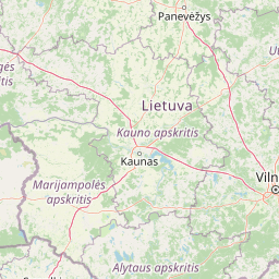
Map view of Mergiškių Nature Reserve

Use this park location map to pinpoint Mergiškių Nature Reserve in Lithuania, understand its exact geographic position, and read its mapped placement within the surrounding landscape more clearly.

Pigeon | © OpenStreetMap contributors

Location context for Mergiškių Nature Reserve

Trakai District Municipality
Park atlas

Compare nearby regional parks and connected woodland reserves across the surrounding landscape

Parks Near Mergiškių Gamtinis Rezervatas and Surrounding Protected Areas

Browsing other parks near Mergiškių gamtinis rezervatas reveals broader ecological patterns across the surrounding regional park network and glacial hill terrain. Comparing adjacent protected areas provides essential geographic context for understanding rare forest habitats and regional conservation zones.
Watercolor painting showing green hills, trees, a body of water, and grassy vegetation
National parkLithuania
About 7.1 km away#1 closest

Northwest

Trakai National Historic Park: Medieval Heritage and Lake District Protected Landscape

Explore Lithuania's historic park and its mapped geographic context.

Trakai National Historic Park offers a rich tapestry of medieval history intertwined with a captivating lake district landscape. As a protected area in southeastern Lithuania, it preserves significant architectural monuments, including the iconic Trakai Castle, set against a backdrop of interconnected lakes, forests, and wetlands. MoriAtlas provides a structured overview of its geographic boundaries and regional setting, facilitating atlas-style exploration of this historically significant protected landscape.

IUCN
V
Access
Moderate access
Scope
Mixed
Watercolor illustration of a wooden boardwalk path winding through a flat landscape with scattered trees, soft grasses, and muted natural colors.
Nature reserveKauno rajono savivaldybė
About 39 km away#2 closest

Northwest

Dubravos rezervatinė apyrubė: Protected Nature Reserve and Baltic Forest Geography

Central Lithuania protected landscape and wetland mapping

This nature reserve in the Kaunas district protects a rare combination of mature pine forest and open raised bog habitats. By preserving long term undisturbed ecological processes, it provides a stable reference point for forest dynamics in the region. Explore the structural complexity of these coniferous stands and the distinct wetland characteristics of this protected Baltic landscape.

Area
1.2 km²
Established
1994
IUCN
Ia
Relief
Lowland
Watercolor illustration showing a landscape with forests, a river, and distant hills
National parkLithuania
About 45 km away#3 closest

South

Dzūkija National Park: Explore Lithuania's Largest Protected Forest and Inland Dune Landscapes

Mapped protected area geography and natural terrain of the Dainava region.

Delve into the protected landscape of Dzūkija National Park, Lithuania's expansive national park renowned for its vast primeval pine forests and extraordinary inland dune formations. This page provides a detailed atlas-style view of the park's mapped boundaries, diverse terrain, and significant natural features, offering insight into its protected territory and regional geographic importance. Examine the unique wetland systems and forest ecosystems that make this a crucial area for protected land discovery.

Area
584.53 km²
Established
1991
IUCN
II
Visitors
30K annual
A horizontal watercolor painting showing a soft, impressionistic landscape with trees on both sides and a gentle rolling hill in the background.
Nature reserveVarėna District Municipality
About 57 km away#4 closest

South

Povilnio Rezervatas: Protected Nature Reserve and Glacial Valley Geography in Varėna District

Glacial landscape study within the Dainava Forest massif

Located in the Varėna District, Povilnio Rezervatas is a protected nature reserve defined by its striking glacial spillway valley and diverse forest communities. This area encompasses a complex mosaic of lichen-rich pine heaths, spruce forests, and alder mires, making it a critical site for botanical conservation and regional geomorphology studies.

Area
1.832 km²
Established
1997
IUCN
Ia
Relief
Lowland
Watercolor illustration of a serene river landscape with green trees, grassy banks, and rolling hills in the background.
Nature reserveVarėna District Municipality
About 59 km away#5 closest

South

Skroblaus rezervatas: Protected Nature Reserve and Baltic Upland Geographic Reference Site

Natural hydrological basin and inland dune landscapes in Varėna District Municipality

Skroblaus rezervatas functions as a strict nature reserve protecting the natural hydrological regime of the Baltic uplands. Located in the Varėna District Municipality, the terrain features deep stream valleys, thermokarst depressions, and inland dune massifs. This mapped area offers a deep look into the geomorphology and forest ecology of southern Lithuania, providing essential context for understanding undisturbed upland water systems.

Area
8.107 km²
Established
1983
IUCN
Ia
Relief
Upland
Biosphere reserveKauno rajonas
About 61 km away#6 closest

Northwest

Babtų-Varluvos miškų biosferos poligonas: Protected Forest Landscapes and Geographic Mapping

Essential woodland corridors in Kaunas district, Lithuania

Babtų-Varluvos miškų biosferos poligonas functions as a significant biosphere reserve focused on mature lowland forest conservation. This protected area offers a look at continuous woodland structures, research-focused biodiversity monitoring, and the spatial significance of forest corridors within central Lithuanian geography.

Area
44.19 km²
Established
2004
IUCN
VI
Relief
Lowland
A watercolor painting showing a wide, panoramic view of a marshy wetland with patches of green vegetation, small trees, and low hills in the distance.
Nature reserveVarėna District Municipality
About 67 km away#7 closest

South

Čepkeliai Nature Reserve: Mapped Geography and Protected Wetland Landscape in Lithuania

A wild expanse of raised bogs and inland dunes.

Čepkeliai Nature Reserve features an exceptionally large and undisturbed raised bog complex situated in southern Lithuania. This protected territory within the Varėna District Municipality spans varied terrain, including stabilized sandy dunes, forested islands, and the Katra River valley. Its complex ecological structure preserves rare bird populations and deep peat deposits that reflect centuries of post-glacial history.

Area
112.12 km²
Established
1975
IUCN
Ia
Relief
Lowland
Biosphere reserveUkmergė District Municipality
About 70 km away#8 closest

North

Viliukų, Karpių miškai Biosphere Reserve: Regional Protected Area Geography and Maps

Broadleaved forests and wetland ecosystems in central Lithuania

Gain insights into the protected landscape of Viliukų, Karpių miškai in the Ukmergė District. This biosphere reserve provides a detailed view of lowland forest ecosystems, characterized by spruce and birch dominance within an undulating terrain that sustains rare insect and plant communities.

Area
7.772 km²
Established
2012
Relief
Lowland
Scope
Terrestrial

Common questions about visiting, size, designation, and location context for Mergiškių Nature Reserve

Mergiškių Nature Reserve FAQs for park facts, access, geography, and protected area context

Find quick answers about Mergiškių Nature Reserve, including protected-area facts, park geography, trail and visitor context, and how the park fits into its surrounding country and regional landscape.
MoriAtlas Explorer

Continue Your Protected Areas Search Across the Global Atlas

Deepen your exploration by continuing the structured search for national parks and protected areas worldwide. Utilize the comprehensive filtering capabilities to compare different conservation landscapes and refine your understanding of global park geography. Discover more about the distribution and characteristics of protected natural areas.

Global natural geography