
Mori Atlas logo
Nature reserveSkroblaus rezervatas

Examine the inland dune formations and natural spring systems within the Varėna District Municipality protected lands

Skroblaus rezervatas Nature Reserve: Mapped Protected Landscapes and Hydrological Geography in Lithuania

(Skroblaus gamtinis rezervatas)

Skroblaus rezervatas represents a core protected landscape within the Varėna District Municipality of Lithuania, serving as a vital hydrological reference site for the Baltic uplands. This reserve preserves a complex terrain where natural spring systems and inter-moraine groundwater drainage patterns converge with dramatic inland dunes and thermokarst depressions. The dense coverage of mature pine and spruce forests creates a stable refuge for diverse flora and fauna, illustrating a pristine environmental baseline characteristic of the region.

hydrological reserveBaltic uplandsinland dunesthermokarstpeatlandsprings
A flat-style digital illustration of a waterfall flowing down a rocky cliff into a river, with a wooden footbridge in the foreground crossing the water, surrounded by tall trees under a soft-toned sky.

Skroblaus rezervatas

Nature reserve

Park overview

Structured park overview, official facts, and landscape profile for Skroblaus Nature Reserve

Skroblaus Nature Reserve park facts, protected area profile, and essential visitor context

Review the core facts for Skroblaus Nature Reserve, including designation, size, terrain, visitor scale, habitats, and operating context in one park-focused overview.

About Skroblaus Nature Reserve

Skroblaus Nature Reserve is a small but ecologically rich strict nature reserve in southern Lithuania, set within the larger protection framework of Dzūkija National Park. It preserves the watershed of the Skroblus stream, one of the few catchments in the Baltic uplands where spring discharge patterns and inter-moraine aquifer drainage have not been altered by drainage works or land-use change. Because of this, the reserve serves as a baseline for understanding how upland Lithuanian hydrology functions under natural conditions.

The terrain is shaped by glacial history. Sand deposited during past glaciations has been reworked into the Ratnyčia-Randamonys dune massif west of the Skroblus, and within this sand sheet the slow collapse of subsurface ice remnants left thermokarst hollows. The largest of these is filled by the Kubilnyčia peatland, which supports unusual fungal communities and rare plants. Where the Skroblus has cut down through the dunes and underlying sediments, it has formed a steep, picturesque valley, especially near the village of Rudnia, where the entire settlement sits in a basin surrounded by pines on very steep slopes.

Ecologically, the reserve combines dry pine forest on the dune ridges, moister spruce stands in the valleys, and fragments of broadleaf forest that together support a notable diversity of rare fungi, vascular plants, and forest mammals. Archaeological traces of historical iron smelting near Kapiniškiai and Rudnia add a small but distinctive cultural layer, reminding visitors that this seemingly remote landscape has supported human activity for centuries.

For Lithuanian conservation, Skroblaus is more than a local patch of protected forest. It functions as a control area for hydrological research, a refuge for species that have retreated elsewhere in the Dzūkija sandy plains, and an outdoor reference site for understanding the interdependence of groundwater, dunes, and forest ecosystems on the Baltic uplands.

Quick facts and research context for Skroblaus Nature Reserve

Skroblaus Nature Reserve is located in Varėna district, southern Lithuania, about 8 kilometers southeast of the town of Merkinė, and lies entirely inside Dzūkija National Park. It was first established in 1983 as the Skroblaus Hydrological Sanctuary before being reclassified as a strict nature reserve in 1997.

The reserve is managed under IUCN Category Ia, the highest level of protection, and focuses primarily on preserving a near-natural hydrological basin and the surrounding dune and forest landscape of the Baltic uplands. Its territory includes the protected natural monuments Rudnios Cirkas and the steep northern and southern hill spurs around Rudnia village.

Protection and recognition

Documented terrestrial protection scope and established conservation timeline

Skroblaus Rezervatas Protection Status and Designated Area History

Skroblaus rezervatas maintains a documented terrestrial protection status established in 1997 through formal designation records. Conservation history details the administrative scope and recognition framework governing this protected landscape.

Protection details

Protection scope
Terrestrial
Designated year
1997
Transboundary protection
No
Park context

Deeper park guide and search-rich context for Skroblaus Nature Reserve

Skroblaus Nature Reserve history, landscape, wildlife, and travel context

Explore Skroblaus Nature Reserve through its history, landscape character, ecosystems, wildlife, conservation priorities, cultural context, and seasonal travel timing in a structured park guide built for atlas discovery and search intent.

Why Skroblaus Nature Reserve stands out

Skroblaus Reserve is best known for being one of the last intact hydrological reference sites on the Baltic uplands, where ascending springs and inter-moraine groundwater drainage still function in a natural state. Equally distinctive is its landscape of inland dunes and thermokarst depressions, most famously around the Kubilnyčia peatland and the spring that feeds it. The Rudnia area is another hallmark feature: the village sits in a deep basin encircled by steep, pine-clad escarpments, giving the reserve a dramatic small-scale terrain that is unusual in Lithuania. The combination of clean water systems, dune morphology, and old-growth forest communities with rare fungi and orchids makes it a key reference site for Lithuanian natural science.
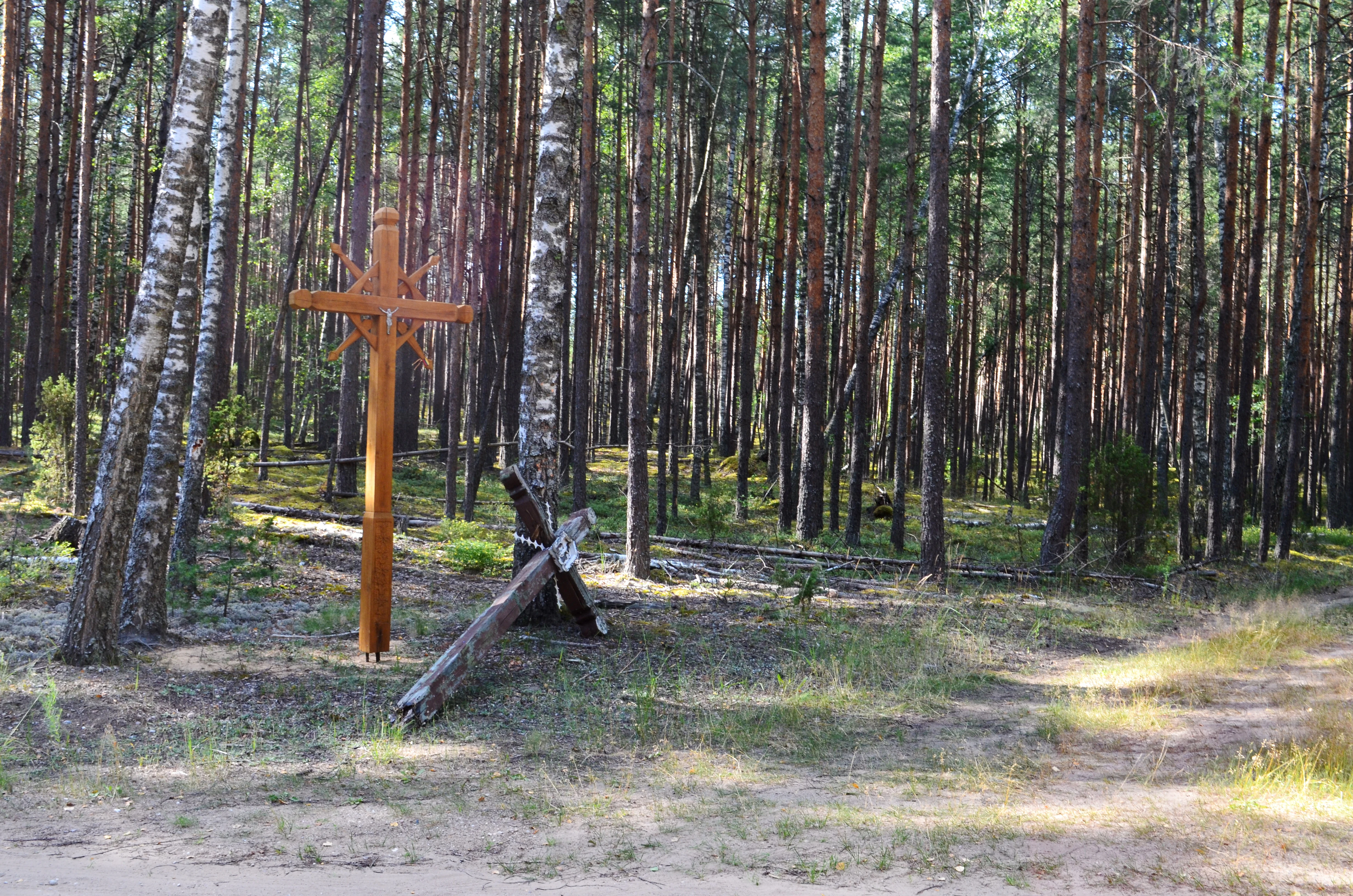
A tall, newly carved wooden cross stands upright in a pine forest, next to an older, leaning, and weathered wooden cross near a dirt trail.
Traditional wooden crosses located along a forest path in Skroblaus Reserve.

Skroblaus Nature Reserve history and protected-area timeline

The area that today forms Skroblaus Nature Reserve first received formal protection in 1983, when it was established as the Skroblaus Hydrological Sanctuary in recognition of the scientific value of its spring systems and inter-moraine drainage.

In 1997, the sanctuary was reclassified and upgraded to a strict nature reserve, reflecting its growing importance as a reference site for upland hydrology and as a refuge for rare species within the broader Dzūkija forest landscape. The reserve is now administered as part of Dzūkija National Park, integrating it into a larger network of natural and cultural heritage sites in southern Lithuania.

Long before formal protection, the reserve's terrain supported scattered human activity. Remains of old iron smelting works can still be traced between the villages of Kapiniškiai and Rudnia, evidence that the forest and stream resources of the Skroblus valley were once part of a small local iron-producing economy.

Skroblaus Nature Reserve landscape and geographic character

The landscape of Skroblaus Nature Reserve is dominated by the meeting of two distinct geomorphological elements: glacially deposited sand plains and a deeply incised stream valley. West of the Skroblus stream lies part of the Ratnyčia-Randamonys dune massif, a sequence of inland dunes that creates an undulating, in places almost desert-like terrain far from any coast.

Within this dune landscape, thermokarst depressions appear where buried ice remnants once collapsed, leaving closed hollows of varying depth. The most prominent is occupied by the Kubilnyčia peatland and its associated spring, a sheltered wetland framed by surrounding dune slopes. Where these permeable sands meet less permeable substrates, ascending springs emerge, feeding the Skroblus and its tributaries with unusually clean groundwater.

The Skroblus itself has carved a steep, narrow valley through the dune and moraine materials, and the most expressive section is the Rudnia basin. Here the stream has produced near-vertical slopes, with the village of Rudnia tucked into a deep amphitheater-like hollow and surrounded by mature pine forest clinging to the escarpments. The interplay of light, sand, spruce, and pine on these steep slopes gives the reserve much of its visual character.
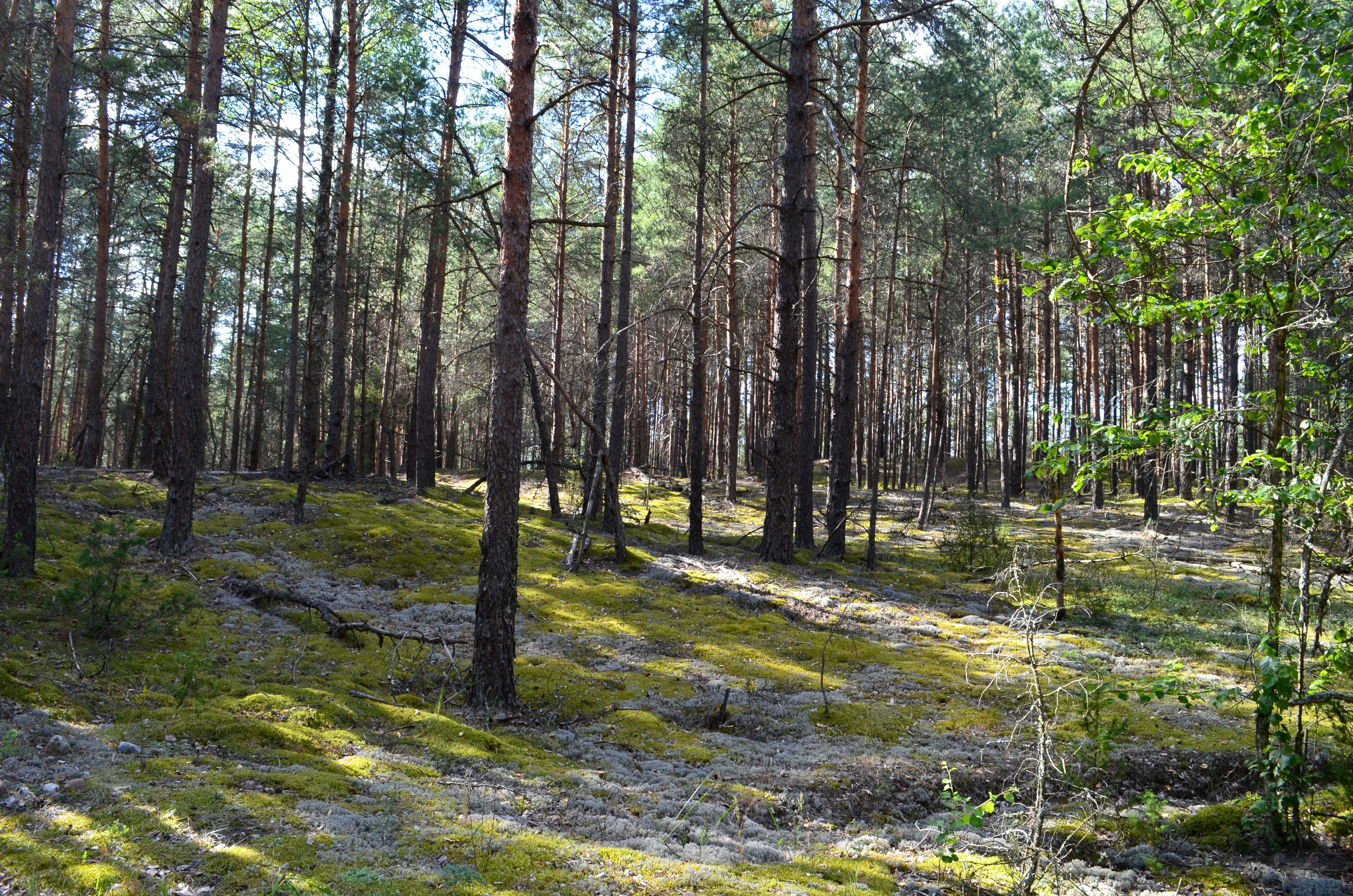
A pine forest in Lithuania with thin tree trunks and a ground cover of green moss and light-colored lichen.
A pine-dominated forest floor covered in moss and lichen within Skroblaus Reserve.

Skroblaus Nature Reserve ecosystems, habitats, and plant life

The reserve sits on a transition between dry sandy habitats and moisture-rich valley systems, producing a small-scale mosaic of ecological conditions. Dry pine forests dominate the dune ridges, while spruce and mixed forests fill the lower slopes and protected hollows, and small patches of broadleaf woodland survive on the most mesic sites. Wetland communities are concentrated around the Kubilnyčia peatland, the springs of the Skroblus, and the broader floodplain of the stream.

Among vascular plants, the reserve harbors a concentration of rare and protected species that is remarkable for such a small area. A particularly notable botanical site lies near the Aukštagiris farmstead, where on a small patch of ground red Cephalanthera, large-flowered self-heal, dark-leaved Cephalanthera-like orchids, and green-flowered night-blooming species grow together, an unusual assemblage of rare forest plants.

The mycological communities are equally distinctive. Mature pine stands host species such as the wrinkled cabbage-head mushroom and velvet antrodia, old spruce forests support the soft pycnoporus, and broadleaf stands shelter the white shield mushroom and bark-dwelling maple polypore, illustrating how each forest type supports its own characteristic fungal community.
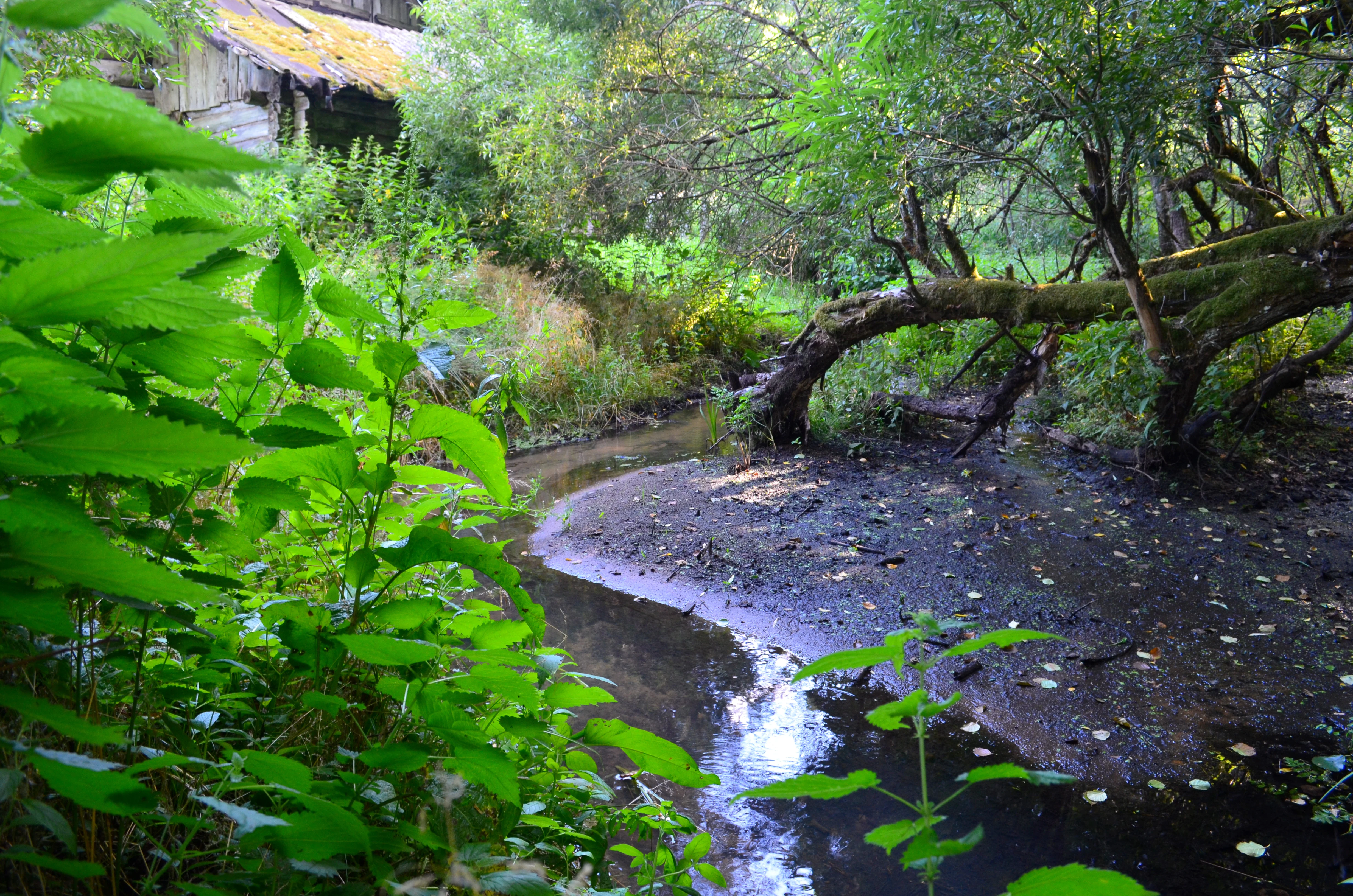
A small, winding forest stream or spring flows through a shaded, lush green woodland area with a fallen tree arching over the water.
The Kubilnycia spring flowing through the natural environment in Rudnele, located within the Skroblaus reserve.

Skroblaus Nature Reserve wildlife and species highlights

Skroblaus Reserve supports a mammal fauna typical of well-preserved southern Lithuanian forests, with beavers frequently modifying stream-side habitat along the Skroblus. Martens and introduced American minks are also present, while the reserve's smaller mammal community is particularly noteworthy: species such as the pygmy shrew, the twin birch mouse, and the forest birch mouse have been recorded here, indicating that the mosaic of forest, peatland, and meadow margins provides habitat for species often lost in more intensively used landscapes.

The reserve is also recognized for its Lepidoptera, with rare moth and butterfly species documented within its boundaries. Notable records include species such as the edible Cidaria moth, the gray-green carpet moth, and the large copper butterfly, all of which depend on specific host plants and microclimates found in the reserve's varied habitats.

Brown trout spawning grounds in the Skroblus are another important element of the reserve's wildlife value, highlighting the connection between clean hydrology and the stream's fish fauna.
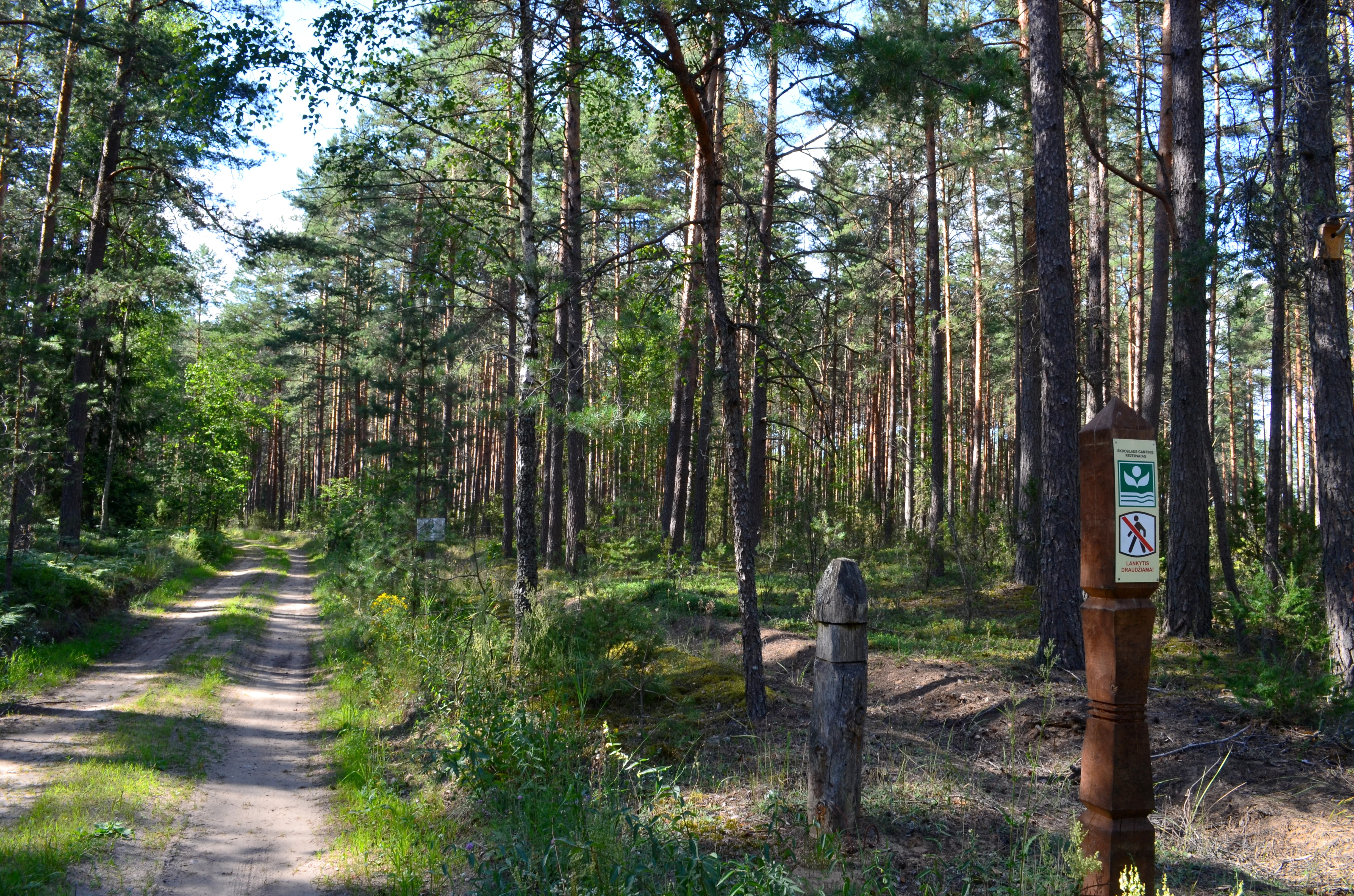
A dirt path leads into a dense pine forest, with a tall, carved wooden post bearing a park sign visible in the right foreground.
A wooden park signage post marks the entrance to the forest at Skroblaus Reserve.

Skroblaus Nature Reserve conservation status and protection priorities

Skroblaus Reserve is a strict nature reserve classified under IUCN Category Ia, the highest level of protection, meaning that its primary purpose is the preservation of ecosystems and natural processes rather than public recreation or resource use. This designation reflects the site's exceptional value as a reference area for upland hydrology and natural forest dynamics.

Conservation significance is closely tied to the reserve's status as a near-natural catchment. Because its springs, aquifers, and stream flow have remained largely undisturbed, the reserve serves as a control site against which hydrological change elsewhere in the Baltic uplands can be measured. It also plays an outsized role for species conservation, sustaining populations of rare plants, fungi, and small mammals in a landscape that has otherwise been heavily modified by forestry and drainage.

The reserve is further protected through its integration into Dzūkija National Park, which provides an additional layer of landscape-scale management and ensures that the reserve is surrounded by a broader buffer of protected forest.

Skroblaus Nature Reserve cultural meaning and human context

The forested valleys and stream banks of what is now the reserve supported small-scale iron production in earlier centuries. Traces of historical iron smelting works can still be detected between the villages of Kapiniškiai and Rudnia, turning the reserve's remote landscape into an open-air archive of pre-industrial rural industry in southern Lithuania.

The villages of Kapiniškiai, Rudnia, and Dubininkas, along with the Aukštagiris farmstead, give the reserve a layered rural identity. Traditional roadside crosses at forest crossroads, some old and some newly erected, are a visible expression of the region's continuing folk Catholic heritage. Old place names and the strong association with Dzūkija National Park also tie the reserve firmly to the broader cultural identity of the Dzūkija region.

Top sights and standout views in Skroblaus Nature Reserve

An IUCN Category Ia strict nature reserve protecting one of the least disturbed hydrological basins on the Baltic uplands, with intact ascending springs and natural inter-moraine drainage patterns.

A dramatic inland dune and thermokarst landscape, including the Kubilnyčia peatland and the steep, pine-framed Rudnia valley of the Skroblus stream, surrounded by old-growth pine, spruce, and broadleaf forest harboring rare plants, fungi, mammals, and butterflies.

Best time to visit Skroblaus Nature Reserve

Late spring and early summer are particularly rewarding for visiting the Skroblaus area, when wildflowers in the forests and along the streams are at their peak and the rare orchid and Cephalanthera species documented near Aukštagiris are most easily observed. Summer offers the fullest experience of the green forest canopy and the cool, spring-fed waters of the Skroblus, while mushroom-rich autumn months can be productive for those interested in the reserve's distinctive fungal communities beneath the mature stands.

Because the reserve is a strictly protected area, any visit should be approached with an emphasis on quiet, low-impact appreciation of the landscape rather than active recreation, and on respecting the boundaries that keep the hydrological and ecological systems intact.
Monthly climate preview

Long term representative measurements tracking monthly precipitation and temperature patterns

Skroblaus Rezervatas Climate Normals and Annual Temperature Rhythm

Representative coordinates record measured multiyear temperature and precipitation variations across twelve distinct monthly intervals for Skroblaus rezervatas. Detailed monthly climate profiles provide complete statistical context for average minimum and maximum readings at a standardized elevation.
Annual mean7 °C
-6 °C19 °C
Jan-6°
Feb-5°
Mar
Apr
May13°
Jun16°
Jul19°
Aug18°
Sep13°
Oct
Nov
Dec-4°
Warmest month
July

18.6 °C

Coolest month
January

-5.7 °C

Wettest month
July

2.9 mm/day

Driest month
March

1.5 mm/day

Park location guide

Geography guide, regional context, and park location map for Skroblaus Nature Reserve

Skroblaus Nature Reserve park geography, regions, and map view in Lithuania

Understand where Skroblaus Nature Reserve sits in Lithuania through a broader geographic reading of the surrounding landscape, nearby location context, and its mapped position within the national park landscape.

How Skroblaus Nature Reserve fits into Lithuania

Lithuania is a unitary semi-presidential republic and one of three Baltic states in Northern Europe. It lies on the eastern coast of the Baltic Sea, with Vilnius as its capital and largest city. The country regained independence in 1990 after Soviet occupation and joined the European Union in 2004. Lithuania has a population of about 2.9 million and covers an area of 65,300 km².

Wider geography shaping Skroblaus Nature Reserve in Lithuania

Lithuania is situated on the eastern shore of the Baltic Sea in Northern Europe. It borders Latvia to the north, Belarus to the east and south, Poland to the south, and Russia's Kaliningrad Oblast to the southwest. The country also has a maritime border with Sweden to the west. The terrain is largely flat with rolling hills, numerous lakes, and rivers. The Nemunas River is the longest river in the country.

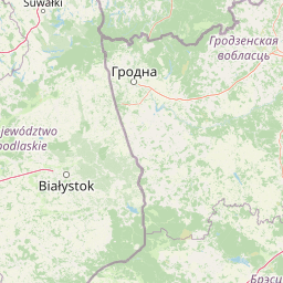
Map view of Skroblaus Nature Reserve

Use this park location map to pinpoint Skroblaus Nature Reserve in Lithuania, understand its exact geographic position, and read its mapped placement within the surrounding landscape more clearly.

Pigeon | © OpenStreetMap contributors

Location context for Skroblaus Nature Reserve

Varėna District Municipality

Explore photographic records of inland dunes, ascending springs, and mature pine forests

Visualizing Skroblaus Rezervatas: Landscape Photography and Protected Scenery

Visual documentation of Skroblaus rezervatas reveals the complex topography of inland dunes, deep stream valleys, and pristine water systems. Photographic evidence provides critical insight into the protected habitats and rare geological formations that define the reserve.

A tall, newly carved wooden cross stands upright in a pine forest, next to an older, leaning, and weathered wooden cross near a dirt trail.

A narrow red pedestrian footbridge spans a small, gently flowing forest stream in a temperate woodland setting.

A pine forest in Lithuania with thin tree trunks and a ground cover of green moss and light-colored lichen.

A small, winding forest stream or spring flows through a shaded, lush green woodland area with a fallen tree arching over the water.

A dirt path leads into a dense pine forest, with a tall, carved wooden post bearing a park sign visible in the right foreground.

Park atlas

Compare regional protected landscapes and surrounding Baltic upland nature reserves

Explore Protected Areas and Parks Near Skroblaus Rezervatas

Browse other protected areas and national parks located near Skroblaus Rezervatas to examine connected regional geography and hydrological formations. Continuing into surrounding reserve landscapes provides broader context for comparing pristine upland ecosystems across the region.
Watercolor illustration showing a landscape with forests, a river, and distant hills
National parkLithuania
Mapped location lies within the park boundary#1 closest

East

Dzūkija National Park: Explore Lithuania's Largest Protected Forest and Inland Dune Landscapes

Mapped protected area geography and natural terrain of the Dainava region.

Delve into the protected landscape of Dzūkija National Park, Lithuania's expansive national park renowned for its vast primeval pine forests and extraordinary inland dune formations. This page provides a detailed atlas-style view of the park's mapped boundaries, diverse terrain, and significant natural features, offering insight into its protected territory and regional geographic importance. Examine the unique wetland systems and forest ecosystems that make this a crucial area for protected land discovery.

Area
584.53 km²
Established
1991
IUCN
II
Visitors
30K annual
A horizontal watercolor painting showing a soft, impressionistic landscape with trees on both sides and a gentle rolling hill in the background.
Nature reserveVarėna District Municipality
About 16 km away#2 closest

East

Povilnio Rezervatas: Protected Nature Reserve and Glacial Valley Geography in Varėna District

Glacial landscape study within the Dainava Forest massif

Located in the Varėna District, Povilnio Rezervatas is a protected nature reserve defined by its striking glacial spillway valley and diverse forest communities. This area encompasses a complex mosaic of lichen-rich pine heaths, spruce forests, and alder mires, making it a critical site for botanical conservation and regional geomorphology studies.

Area
1.832 km²
Established
1997
IUCN
Ia
Relief
Lowland
A watercolor painting showing a wide, panoramic view of a marshy wetland with patches of green vegetation, small trees, and low hills in the distance.
Nature reserveVarėna District Municipality
About 19 km away#3 closest

Southeast

Čepkeliai Nature Reserve: Mapped Geography and Protected Wetland Landscape in Lithuania

A wild expanse of raised bogs and inland dunes.

Čepkeliai Nature Reserve features an exceptionally large and undisturbed raised bog complex situated in southern Lithuania. This protected territory within the Varėna District Municipality spans varied terrain, including stabilized sandy dunes, forested islands, and the Katra River valley. Its complex ecological structure preserves rare bird populations and deep peat deposits that reflect centuries of post-glacial history.

Area
112.12 km²
Established
1975
IUCN
Ia
Relief
Lowland
Watercolor painting of a tranquil marshland scene with reeds in the foreground, rolling green hills, and a pale sky.
Nature reservePodlaskie Voivodeship
About 50 km away#4 closest

West

Ostoja Augustowska Nature Reserve: Protected Forest and Wetland Atlas of Podlaskie

Mapped wilderness corridors in the Polish lowlands

Ostoja Augustowska serves as a major ecological hub in Podlaskie Voivodeship, comprising extensive pine and spruce woodlands linked with diverse peatland systems. The site provides a critical corridor for rare forest wildlife while preserving ancient stands of old-growth timber. Gain insights into the complex geography of this Natura 2000 protected territory through its documented terrain, hydrological networks, and mosaic of rare boreal habitat types.

Area
1,070.69 km²
Established
2009
Relief
Lowland
Climate
Temperate
Nature reserveTrakai District Municipality
About 59 km away#5 closest

North

Mergiškių gamtinis rezervatas Protected Nature Reserve in Trakai District Municipality

Strictly protected hornbeam woodland and hilly glacial terrain

Mergiškių gamtinis rezervatas is a protected area in Lithuania dedicated to conserving mature hornbeam-dominated hill forest. Located within the Trakai District Municipality, the reserve provides a critical habitat for threatened species and maintains the natural integrity of hilly glacial landscapes typical of the Aukštadvaris region.

Area
1.57 km²
Established
1996
IUCN
Ia
Relief
Upland
Watercolor painting showing green hills, trees, a body of water, and grassy vegetation
National parkLithuania
About 62 km away#6 closest

North

Trakai National Historic Park: Medieval Heritage and Lake District Protected Landscape

Explore Lithuania's historic park and its mapped geographic context.

Trakai National Historic Park offers a rich tapestry of medieval history intertwined with a captivating lake district landscape. As a protected area in southeastern Lithuania, it preserves significant architectural monuments, including the iconic Trakai Castle, set against a backdrop of interconnected lakes, forests, and wetlands. MoriAtlas provides a structured overview of its geographic boundaries and regional setting, facilitating atlas-style exploration of this historically significant protected landscape.

IUCN
V
Access
Moderate access
Scope
Mixed
Watercolor painting showing a wetland scene with reeds, patches of water, and trees under a light sky
National parkPodlaskie Voivodeship
About 68 km away#7 closest

Southwest

Biebrza National Park: Protected Fenlands and River Basin Geography in Northeastern Poland

Tracing the largest lowland peat bog complex in the European landscape

Biebrza National Park serves as the premier protected wetland area in Poland, characterized by its vast, intact marshlands and the meandering Biebrza River valley. This geographic profile details the park's critical fen ecosystems, floodplain dynamics, and distinctive habitats that support diverse avian and mammalian populations within the Podlaskie region.

Area
592.23 km²
Established
1993
IUCN
II
Relief
Lowland
A watercolor painting of a flat wetland landscape with a winding river in the foreground, small clusters of trees, and rolling hills in the soft, distant background.
National parkPodlaskie Voivodeship
About 68 km away#8 closest

Southwest

Biebrzański Park Narodowy: A Protected Wetland Landscape in Podlaskie Voivodeship, Poland

Mapped river valley and peatland geography.

Located in the northeast of Poland, Biebrzański Park Narodowy protects a sprawling, flat basin defined by the slow-meandering Biebrza River. This critical protected area encompasses rare peat bogs, floodplain meadows, and alder carrs, functioning as a vital refuge for wetland species within the broader Podlaskie Voivodeship landscape.

Area
592.23 km²
Established
1993
Visitors
23.2K annual
Relief
Lowland

Common questions about visiting, size, designation, and location context for Skroblaus Nature Reserve

Skroblaus Nature Reserve FAQs for park facts, access, geography, and protected area context

Find quick answers about Skroblaus Nature Reserve, including protected-area facts, park geography, trail and visitor context, and how the park fits into its surrounding country and regional landscape.
MoriAtlas Explorer

Continue Your Protected Areas Search Across the Global Atlas

Deepen your exploration by continuing the structured search for national parks and protected areas worldwide. Utilize the comprehensive filtering capabilities to compare different conservation landscapes and refine your understanding of global park geography. Discover more about the distribution and characteristics of protected natural areas.

Global natural geography