

Mori Atlas logo
National parkMeru National Park

Discover the mapped geography and regional context of Meru National Park.

Meru National Park: Protected Landscape and National Park Boundaries in Eastern Province

Meru National Park stands as a significant protected area within Eastern Province, Kenya, offering a distinct landscape for atlas-driven discovery. This canonical page provides an in-depth look at its protected boundaries and its contribution to regional geography. Users can explore the mapped terrain and understand Meru National Park's place within Kenya's network of conservation lands, focusing on its geographic identity and natural landscape features.

Big FiveSavannaRiparian ForestRiver SafariConservation HistoryMount Kenya Views

Meru National Park

National park

Park overview

Structured park overview, official facts, and landscape profile for Meru National Park

Meru National Park park facts, protected area profile, and essential visitor context
Review the core facts for Meru National Park, including designation, size, terrain, visitor scale, habitats, and operating context in one park-focused overview.

About Meru National Park

Meru National Park represents one of Kenya's most significant protected areas, offering visitors an immersive wilderness experience in a region that combines outstanding biodiversity with profound conservation history. The park's location in the rain shadow of Mount Kenya creates a unique ecological enclave within Kenya's generally semi-arid eastern landscape. The western portions of the park benefit from orographic rainfall, supporting extensive swamp systems and tall grasslands that contrast sharply with the acacia-dotted savanna found in the drier eastern reaches. This environmental diversity translates directly into remarkable wildlife viewing opportunities, as the park supports healthy populations of elephants, lions, leopards, rhinoceros, and numerous other species. The Tana River, which bisects the park from west to east, provides a permanent water source that sustains wildlife throughout the dry season and supports riparian forests teeming with birdlife. Perhaps most importantly, Meru National Park serves as a living testament to the pioneering conservation work of George and Joy Adamson, whose patient work with Elsa the Lioness helped change humanity's relationship with wild animals and inspired modern wildlife conservation movements worldwide.

Quick facts and research context for Meru National Park

Meru National Park spans approximately 870 square kilometers in eastern Kenya's former Eastern Province, positioned east of the town of Meru and roughly 350 kilometers from Nairobi. The park was established in 1966 and is managed by the Kenya Wildlife Service. The area features a unique moisture gradient across its terrain, with wetter western sections supporting tall grasslands and permanent swamps, while eastern areas are more arid with shorter vegetation. The park contains the Tana River, Kenya's longest river, which provides critical water resources for wildlife throughout the year. The park is part of a Lion Conservation Unit designated in 2005 and has undergone significant restoration since the early 2000s following a period of poaching-related decline.

Park context

Deeper park guide and search-rich context for Meru National Park

Meru National Park history, landscape, wildlife, and travel context
Explore Meru National Park through its history, landscape character, ecosystems, wildlife, conservation priorities, cultural context, and seasonal travel timing in a structured park guide built for atlas discovery and search intent.

Why Meru National Park stands out

Meru National Park is best known for its deep connection to the conservation movement and the world-famous lioness Elsa, raised by George and Joy Adamson and immortalized in the 1966 film Born Free. The park contains the burial sites of both Joy Adamson and Elsa the Lioness, making it a pilgrimage site for wildlife enthusiasts and conservation-minded visitors. Beyond this remarkable heritage, the park protects a remarkable concentration of megafauna including all of Africa's Big Five: African bush elephants, lions, African leopards, rhinoceros (both eastern black and southern white), and buffalo. The park's landscape, characterized by rolling savanna, riverine forests along the Tana River, and the imposing presence of Mount Kenya to the west, creates one of Kenya's most visually striking wilderness settings.

Meru National Park history and protected-area timeline

Meru National Park was established in 1966 as part of Kenya's growing network of protected areas during the post-independence period of national park development. The park's modern history is defined by a dramatic cycle of decline and revival that occurred in the late twentieth century. Between the 1980s and late 1990s, the park suffered severely from poaching and civil unrest, reaching a point where wildlife populations were severely depleted and infrastructure deteriorated significantly. The turning point came between 2000 and 2005, when the Kenya Wildlife Service, with substantial support from the Agence Française de Développement and the International Fund for Animal Welfare, launched a comprehensive restoration program. This initiative, supported by a $1.25 million donation from IFAW, focused on rebuilding infrastructure, equipping anti-poaching units, and restoring wildlife populations. The success of this restoration effort transformed Meru from one of Kenya's most troubled parks into one of its most promising tourism destinations. In 2005, the park was incorporated into a Lion Conservation Unit recognizing its importance for East African lion population management.

Meru National Park landscape and geographic character

Meru National Park occupies a diverse terrain shaped by its proximity to Mount Kenya and the presence of the Tana River. The landscape features rolling plains dotted with acacia trees, interspersed with rocky outcrops and patches of denser bushland. The western sections of the park, benefiting from higher rainfall, contain extensive swamp areas and tall grasslands that can reach several meters in height during the wet season. The Tana River, Kenya's longest river, flows through the park from west to east, creating a verdant ribbon of riparian forest that contrasts dramatically with the surrounding savanna. In the distance, the massive volcanic bulk of Mount Kenya rises prominently to the west, its glaciated summit visible on clear days and providing a stunning backdrop to the savanna landscape. The eastern portions of the park transition into more arid terrain with shorter grass cover and more scattered vegetation, representing the typical eastern Kenya ecosystem. This varied topography supports different wildlife communities across relatively short distances, making Meru an excellent destination for diverse safari experiences.

Meru National Park ecosystems, habitats, and plant life

The ecological character of Meru National Park reflects its position in a transitional zone between Kenya's central highlands and eastern lowlands. The park's higher rainfall in the western sections supports lush grasslands and permanent swamp habitats that are unusual in eastern Kenya, creating conditions favoring diverse wildlife and vegetation. Riverine forests along the Tana River provide critical habitat for numerous bird species and serve as corridors for larger mammals moving through the landscape. The combination of savanna, woodland, and wetland habitats within a relatively compact area creates remarkable ecological diversity. The park's location relative to Mount Kenya also means it lies within broader migratory pathways for wildlife moving between highland and lowland ecosystems. This ecological richness makes Meru important not only as a protected area but as a functioning component of Kenya's broader wilderness ecosystem.

Meru National Park wildlife and species highlights

Meru National Park supports impressive populations of Africa's most iconic wildlife species, including all of the Big Five mammals. African bush elephants move through the park in substantial numbers, particularly along the Tana River and near the permanent swamps where they browse on aquatic vegetation. Lions are well-represented, and the park's inclusion in a Lion Conservation Unit reflects its importance for East African lion populations. Both eastern black rhinoceros and southern white rhinoceros occur in the park, though populations were severely impacted by poaching in the late twentieth century and have been the focus of intensive conservation efforts. African leopards and cheetahs stalk the savanna, while large herds of Grévy's zebra, a distinctive subspecies with narrow stripes and rounded ears, graze the grasslands. Hippopotamuses congregate in the Tana River's deeper pools, while buffalo, giraffes, and various antelope species including impalas, Coke's hartebeests, and gerenuks complete the mammalian community. The birdlife is equally impressive, with the riverine forests and swamp edges supporting numerous waterbird species and raptors circling overhead.

Meru National Park conservation status and protection priorities

Meru National Park represents an important case study in successful conservation recovery and the value of international collaboration in protecting wilderness areas. The park's near-collapse in the late 1990s and subsequent remarkable recovery following the 2000-2005 restoration program demonstrates both the vulnerability of protected areas to poaching pressures and the potential for successful intervention when adequate resources and commitment are applied. The involvement of international organizations including the International Fund for Animal Welfare and Agence Française de Développement provided critical funding and expertise that enabled infrastructure development, equipment provision, and anti-poaching operations. The park's designation as part of a Lion Conservation Unit in 2005 reflects its recognized importance for maintaining viable populations of East African lions, a subspecies facing significant conservation challenges across its range. Meru's conservation significance extends beyond individual species to the protection of a complete ecosystem including savanna, woodland, riverine forest, and wetland habitats.

Meru National Park cultural meaning and human context

Meru National Park's cultural significance derives primarily from its connection to George and Joy Adamson, the pioneering conservationists who made the park internationally famous through their work with Elsa the Lioness. The Adamsons established their camp in what is now Meru National Park during the 1950s, where they successfully raised Elsa from a cub after her mother was killed by hunters. Their patient, groundbreaking approach to wildlife rehabilitation and their philosophy of respecting animals as wild beings rather than domesticating them established principles that continue to influence modern conservation thinking. After Joy Adamson's death in 1980, her ashes were scattered at Elsa's grave within the park, creating a memorial that visitors can still visit today. This connection to Born Free, one of the best-selling wildlife books in history and a landmark film that brought wildlife conservation into popular consciousness, gives Meru a unique place in global conservation heritage.

Top sights and standout views in Meru National Park

Meru National Park offers visitors multiple layers of experience, from outstanding wildlife viewing to profound historical significance. The burial sites of Elsa the Lioness and Joy Adamson provide a unique pilgrimage opportunity for those interested in conservation history, while the surrounding landscape remains a thriving wilderness supporting all of Africa's Big Five. The Tana River provides a scenic focus for game drives, with hippos and crocodiles inhabiting its waters and elephant herds coming to drink. Views of Mount Kenya's snow-capped summit add a dramatic backdrop to safari adventures, particularly memorable at sunrise and sunset when the light transforms the landscape. The park's recovery from its troubled past has created a well-maintained infrastructure while preserving the wild character that makes Kenyan national parks legendary.

Best time to visit Meru National Park

Meru National Park can be visited year-round, though certain seasons offer distinct advantages for wildlife viewing and overall experience. The long rains typically occur from April through June, transforming the landscape into lush green but potentially making some roads difficult to navigate. The short rains generally fall in November and December. The dry seasons, from January through March and July through October, typically offer easier access and more concentrated wildlife viewing as animals congregate around remaining water sources. The period immediately following the rains, when vegetation is still green but roads have improved, often provides excellent conditions. Visitors interested in the park's historical sites should note that the Adamson camp and burial sites are accessible throughout the year with park guides.
Park location guide

Geography guide, regional context, and park location map for Meru National Park

Meru National Park park geography, regions, and map view in Kenya
Understand where Meru National Park sits in Kenya through a broader geographic reading of the surrounding landscape, nearby location context, and its mapped position within the national park landscape.

How Meru National Park fits into Kenya

Kenya is a presidential republic in East Africa and the seventh-most populous country on the continent. Its capital is Nairobi, and it borders five countries and the Indian Ocean. The country features significant geographic diversity including Mount Kenya, the Rift Valley, and coastal regions.

Wider geography shaping Meru National Park in Kenya

Kenya is located in East Africa, bordering South Sudan to the northwest, Ethiopia to the north, Somalia to the east, Tanzania to the southwest, and Uganda and Lake Victoria to the west. The southeastern border meets the Indian Ocean. The geography includes the Rift Valley highlands with Mount Kenya, coastal plains, and northern arid regions.

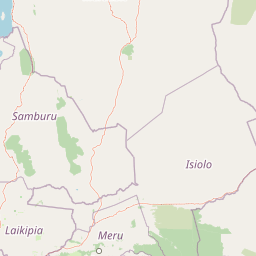
Map view of Meru National Park

Use this park location map to pinpoint Meru National Park in Kenya, understand its exact geographic position, and read its mapped placement within the surrounding landscape more clearly.

Pigeon | © OpenStreetMap contributors

Location context for Meru National Park

Eastern Province
Park atlas

Map the diverse protected landscapes and compare park geography in the region surrounding Meru National Park, Eastern Kenya.

Explore Nearby National Parks and Protected Areas Beyond Meru National Park, Kenya
After exploring Meru National Park, browse other national parks and protected areas across its expansive East African savanna and riparian forest landscapes. Continue your atlas-style park discovery by comparing nearby conservation zones, tracing the geographic spread of diverse ecosystems beyond Meru's immediate boundaries.
National parkTana River County

Kora National Park: A Unique Protected Landscape in Tana River County, Kenya

Explore its inselberg geography and mapped natural terrain.

Kora National Park represents a remarkable protected area characterized by its striking inselberg topography and semi-arid bushland, set against the backdrop of the Tana River. This national park in Tana River County offers a unique geographic profile, featuring massive granite formations that punctuate the expansive terrain. Discover the mapped boundaries and the distinctive landscape that make Kora National Park a significant entity for regional atlas exploration and understanding protected lands in eastern Africa.

Area
1,788 km²
Established
1989
IUCN
II
Relief
Mixed relief
National parkKenya

Mount Kenya National Park: Mapped Volcanic Landscape & Protected Area Geography

Kenya's high-altitude Afro-alpine ecosystems and mapped park boundaries.

Mount Kenya National Park safeguards a globally significant volcanic landscape and vital water resources for Kenya. This protected area above 3,000 meters features dramatic peaks, glaciers, and distinctive Afro-alpine flora. Explore its comprehensive mapped boundaries, understand its regional geographic importance, and discover the unique ecosystems that define this exceptional national park through detailed atlas context.

Area
715 km²
Established
1949
IUCN
II
Relief
Mountain
National parkNyeri County

Aberdare National Park: Mapped Protected Landscape in Nyeri County

National Park Geography and Atlas Context

Aberdare National Park is a protected national park located within Nyeri County, Kenya. This entry offers detailed geographic information and map context, highlighting its protected boundaries and landscape characteristics. Users can explore its regional setting, understand its specific terrain features, and discover its significance as a conservation area within the Kenyan geography. Access structured data that clarifies the park's identity as a vital protected landscape.

Area
767 km²
Established
1950
IUCN
II
Relief
Mountain
National parkKenya

Nairobi National Park: Detailed Geographic Overview and Protected Landscape Atlas

Explore the mapped boundaries and regional context of this Kenyan national park.

Nairobi National Park represents a significant protected national park entity within Kenya. This MoriAtlas entry provides detailed insight into its geographic placement and mapped landscape characteristics. Users can delve into the park's specific location, its protected boundaries, and its contribution to the regional geography of East Africa, facilitating structured map-based exploration and understanding of this vital conservation area.

Area
117 km²
Established
1946
IUCN
II
Relief
Mixed relief
National parkNakuru County

Hell's Gate National Park: National Park Atlas and Mapped Landscape Exploration

Discover Nakuru County's protected terrain and geographic context.

Explore the mapped boundaries and unique geographic identity of Hell's Gate National Park, a protected national park within Kenya's Nakuru County. This detailed atlas view focuses on the park's natural landscape and its place within the regional geography, offering structured discovery of its protected terrain and surrounding context. Understand the visual and geographic essence of this significant conservation area.

Area
68.25 km²
Established
1984
IUCN
II
Relief
Mountain
National parkMarsabit County

Marsabit National Park: Protected Area Identity and Geographic Setting in Kenya

Explore mapped landscape and regional park geography.

Marsabit National Park represents a critical protected area within the geographic expanse of Marsabit County, Kenya. This entry provides essential context for understanding the park's specific identity as a national park, its delineated boundaries, and its place within the natural landscape. For those interested in atlas-style exploration, this park detail offers foundational geographic information and insights into its protected status, anchoring its role in a broader discovery of Kenya's natural heritage.

Area
1,554 km²
Established
1949
Relief
Mountain
Climate
Subtropical
National parkKenya

Amboseli National Park: Kenya National Park Protected Landscape Atlas

Mapped geographic context and protected area boundaries.

Amboseli National Park is a protected national park in Kenya, offering a distinct geographic entity for exploration. This atlas-focused view details the park's mapped boundaries and regional landscape context. Understand its role as a national park and a significant protected area within the broader geography of Kenya for structured discovery.

Area
392 km²
Established
1974
IUCN
II
Visitors
120K annual
National parkKenya

Tsavo East National Park: Kenya's Protected Natural Landscape for Geographic Exploration

Explore mapped boundaries and regional park geography.

Tsavo East National Park in Kenya offers a rich entry point for understanding protected landscapes and regional geography. As a designated national park, its mapped boundaries and natural terrain provide essential context for geographic exploration within East Africa. This page serves as a focused discovery point for the park's specific environmental attributes and its role in the broader atlas of protected areas.

Area
13,747 km²
Established
1948
IUCN
II
Relief
Lowland

Common questions about visiting, size, designation, and location context for Meru National Park

Meru National Park FAQs for park facts, access, geography, and protected area context
Find quick answers about Meru National Park, including protected-area facts, park geography, trail and visitor context, and how the park fits into its surrounding country and regional landscape.
MoriAtlas Explorer

Continue Your Protected Areas Search Across the Global Atlas

Deepen your exploration by continuing the structured search for national parks and protected areas worldwide. Utilize the comprehensive filtering capabilities to compare different conservation landscapes and refine your understanding of global park geography. Discover more about the distribution and characteristics of protected natural areas.

Global natural geography