

Mori Atlas logo
Wildlife reserveMeseta de Cacaxtla Flora and Fauna Protection Area

Tracing the protected boundaries where dry forest ecosystems meet the Pacific Ocean coastline

Meseta de Cacaxtla Flora and Fauna Protection Area: Coastal Sinaloa Geography and Protected Landscapes

The Meseta de Cacaxtla Flora and Fauna Protection Area serves as a vital conservation landscape covering 508 square kilometers along the coast of Sinaloa. This reserve features a distinctive mosaic of terrain, transitioning from arid tropical thorn scrub and inland plateau landscapes to coastal mangrove systems, lagoons, and Pacific beaches. By protecting this coastal stretch between Mazatlán and the interior, the reserve provides critical ecological continuity within the Sinaloan dry forest ecoregion.

dry forestsSinaloathorn scrubmangrovescoastal lagoonPacific coast

Meseta de Cacaxtla Flora and Fauna Protection Area

Wildlife reserve

Park overview

Structured park overview, official facts, and landscape profile for Meseta de Cacaxtla Flora and Fauna Protection Area

Meseta de Cacaxtla Flora and Fauna Protection Area park facts, protected area profile, and essential visitor context

Review the core facts for Meseta de Cacaxtla Flora and Fauna Protection Area, including designation, size, terrain, visitor scale, habitats, and operating context in one park-focused overview.

About Meseta de Cacaxtla Flora and Fauna Protection Area

Meseta de Cacaxtla Flora and Fauna Protection Area sits in the state of Sinaloa, along the western Pacific coast of Mexico. Its position places it within a transitional belt where the arid tropical lowlands of the Sinaloan dry forests meet the marine influence of the Pacific Ocean. The protected area occupies a meseta, or elevated plateau, that extends toward the coast, giving it a varied terrain that includes inland dry forest down to coastal lagoons and open shoreline.

Geographically, the reserve is bounded on the west by the Pacific Ocean and on the east by Mexican Federal Highway 15, a major corridor running through northwestern Mexico. Mexican Federal Highway 15D, the parallel toll route, actually passes through the interior of the protected area, parallel to the shore. The nearest significant city is Mazatlán, one of Sinaloa's principal Pacific coastal centers. The protected area's accessibility, framed between the coast and a major highway, places it within an important regional context where ecological protection sits alongside active coastal and transportation land use.

Ecologically, Meseta de Cacaxtla is defined by the Sinaloan dry forests ecoregion, an area of arid and semi-arid vegetation adapted to low rainfall and warm temperatures. Within this ecoregional setting, the reserve includes deciduous thorn scrub typical of the region, mangrove communities along sheltered coastal waters, coastal lagoon systems, and beach habitats along the Pacific shore. The variety of habitats supporting both terrestrial and coastal-marine biodiversity means the protected area has value for species that depend on seasonally dry forests, mangrove-estuarine systems, and beach-coastal interfaces.

The protected area is administered by Mexico's National Commission of Natural Protected Areas and was formally designated in 2000. Its inclusion in the country's federal protected areas system reflects recognition of the ecological importance of the Sinaloan dry forests and the coastal habitats they connect to. While the reserve covers a meaningful portion of land and coastline, it is also notable for being part of a broader network of protected natural areas that safeguard Mexico's diverse regional ecosystems.

Quick facts and research context for Meseta de Cacaxtla Flora and Fauna Protection Area

Meseta de Cacaxtla is a flora and fauna protection area located in Sinaloa, on western Mexico's Pacific coast. It was designated in 2000 and is administered by Mexico's National Commission of Natural Protected Areas (CONANP). Under the IUCN system, it is classified as Category VI, recognizing a protected area with sustainable use of natural resources.

The reserve spans around 508 square kilometers and lies between the Pacific Ocean and Mexican Federal Highway 15, with Highway 15D passing through it parallel to the shore. Its nearest major city is Mazatlán. The protected area is part of the Sinaloan dry forests ecoregion and encompasses thorn scrub, mangrove, coastal lagoon, and beach habitats, with recorded flora and fauna biodiversity reported by CONABIO in the thousands.

Protection and recognition

Documented protection history and official conservation scope facts

Meseta de Cacaxtla Flora and Fauna Protection Area Status and Recognition

Meseta de Cacaxtla Flora and Fauna Protection Area holds a mixed protection scope established in the year 2000. Documented designation records compile historical management facts and official status details without external international recognition sources.

Protection details

Protection scope
Mixed
Designated year
2000
Transboundary protection
No
Park context

Deeper park guide and search-rich context for Meseta de Cacaxtla Flora and Fauna Protection Area

Meseta de Cacaxtla Flora and Fauna Protection Area history, landscape, wildlife, and travel context

Explore Meseta de Cacaxtla Flora and Fauna Protection Area through its history, landscape character, ecosystems, wildlife, conservation priorities, cultural context, and seasonal travel timing in a structured park guide built for atlas discovery and search intent.

Why Meseta de Cacaxtla Flora and Fauna Protection Area stands out

Meseta de Cacaxtla is best known for protecting a representative section of the Sinaloan dry forests, one of Mexico's most ecologically distinctive ecoregions, set against a backdrop of Pacific coastline, mangrove-fringed lagoons, and lowland thorn scrub. The reserve's combination of arid tropical forest, coastal wetlands, and beach ecosystems in a single contiguous protected landscape gives it a strong identity within Mexico's Pacific coast conservation framework.

Meseta de Cacaxtla Flora and Fauna Protection Area history and protected-area timeline

Meseta de Cacaxtla Flora and Fauna Protection Area was formally designated as a Mexican federal protected area in 2000. Its establishment was part of Mexico's broader effort to formalize protection for representative ecosystems across the country, including the increasingly recognized Sinaloan dry forests ecoregion along the Pacific coast.

Following its designation, the reserve came under the administration of the National Commission of Natural Protected Areas, the federal body responsible for managing Mexico's system of natural protected areas. The protected area's designation placed the Sinaloan dry forests ecosystem, along with the associated coastal mangrove and lagoon habitats, within the country's formal conservation framework. The reserve's location, bounded by the Pacific Ocean and a major federal highway corridor, also reflects the regional context of conservation in northwestern Mexico, where protected areas often coexist with significant human activity along the coast and transportation routes.

Meseta de Cacaxtla Flora and Fauna Protection Area landscape and geographic character

The landscape of Meseta de Cacaxtla is defined by a transition from dry inland terrain to a Pacific coastal setting. The reserve occupies part of an elevated plateau, or meseta, from which it takes its name, and this plateau landscape slopes toward the coast on its western edge. The eastern boundary is marked by Mexican Federal Highway 15, while the corresponding toll highway, Highway 15D, cuts through the protected area parallel to the shoreline.

At the coast, the terrain shifts from terrestrial dry forest to a coastal zone shaped by mangroves, coastal lagoons, and sandy beaches along the Pacific Ocean. This layered terrain, from inland dry scrub to estuarine and beach environments, gives the protected area a distinct physical character that combines arid tropical lowland features with marine-influenced coastal geography. The result is a landscape where the interior plateau, coastal lagoons, mangrove margins, and open ocean beach environments are all part of the same protected mosaic.

Meseta de Cacaxtla Flora and Fauna Protection Area ecosystems, habitats, and plant life

The ecological identity of Meseta de Cacaxtla is closely tied to the Sinaloan dry forests ecoregion, a biome characterized by arid and semi-arid conditions and adapted vegetation communities. Within this broader ecoregional setting, the protected area supports a range of habitat types that define its ecological character.

Deciduous thorn scrub is a dominant vegetation type, covering much of the inland portion of the reserve and reflecting the dry-forest conditions typical of the Sinaloan coast. Along the coast, mangrove communities thrive in sheltered areas, supporting mangrove ecosystems that link terrestrial vegetation with estuarine and marine waters. Coastal lagoon systems, fed by both marine and freshwater influences, and open sandy beaches along the Pacific complete the habitat mosaic.

This combination of inland dry forest, mangrove, lagoon, and beach habitats gives the protected area ecological diversity that goes beyond a simple dry forest preserve. It supports biological communities adapted to seasonally dry conditions, estuarine dynamics, and coastal-open beach environments, all within a single protected framework. According to CONABIO biodiversity records referenced in the park's documentation, the protected area contains well over a thousand recorded plant and animal species, with a sizable share falling within at-risk categories or classified as exotic, underscoring both its species richness and its conservation relevance.

Meseta de Cacaxtla Flora and Fauna Protection Area wildlife and species highlights

The wildlife of Meseta de Cacaxtla reflects the diversity of habitats the reserve protects across its dry forest, mangrove, lagoon, and beach environments. The Sinaloan dry forests ecoregion supports species adapted to arid and seasonally dry tropical conditions, while the mangrove and coastal lagoon systems add estuarine and marine-associated fauna. Open Pacific beach habitats provide additional interface zones for shore-associated and seabird-related wildlife.

The protected area's biodiversity records, as documented through CONABIO, indicate that the reserve supports well over a thousand plant and animal species, including a notable share of species considered at risk. This combination of habitat types, ranging from thorn scrub to mangrove, gives the reserve relevance for both resident dry-forest wildlife and species that depend on coastal wetland and shoreline environments. The presence of exotic species in the documented records also points to the importance of monitoring and management within the protected area's ecological framework.

Meseta de Cacaxtla Flora and Fauna Protection Area conservation status and protection priorities

Meseta de Cacaxtla is significant from a conservation perspective because it protects a representative segment of the Sinaloan dry forests ecoregion, a biome recognized for its distinct ecological character along Mexico's Pacific coast. By formalizing protection for this area in 2000, Mexico's federal protected areas system extended conservation coverage to a region that includes both arid tropical forest and coastal ecosystems.

The reserve's conservation value comes in part from the diversity of ecosystems it encompasses. Dry forest, mangrove, coastal lagoon, and beach habitats each face distinct pressures, and protecting them within a single contiguous area provides an integrated approach to conservation along the Sinaloan coast. The reserve's biodiversity records reflect a notable presence of species in at-risk categories, reinforcing the importance of formal protection for maintaining regional biodiversity.

Under IUCN Category VI classification, the area is recognized as a protected area with sustainable use of natural resources, indicating a management approach that balances ecological preservation with compatible human activities. Administered by Mexico's National Commission of Natural Protected Areas, the reserve fits within the country's federal conservation framework and contributes to the broader effort to safeguard representative Mexican ecosystems through formal protection.

Top sights and standout views in Meseta de Cacaxtla Flora and Fauna Protection Area

Meseta de Cacaxtla's defining strength is the combination of Sinaloan dry forests, mangrove, coastal lagoon, and Pacific beach habitats within a single protected landscape along the coast of Sinaloa. Its location between the Pacific Ocean and a major federal highway corridor places it within an active regional setting while still maintaining a substantial continuous protected footprint of around 508 square kilometers.

Another notable aspect of the protected area is its formal recognition within both Mexico's federal protected areas system and the IUCN's Category VI designation, indicating a focus on sustainable use alongside conservation. The reserve's documented biodiversity, including a significant number of at-risk species and a wide total species count, positions Meseta de Cacaxtla as an ecologically meaningful site within Mexico's network of Pacific coast protected areas.

Best time to visit Meseta de Cacaxtla Flora and Fauna Protection Area

Meseta de Cacaxtla sits within the Sinaloan dry forests region, where seasonal conditions shape both wildlife activity and landscape character. The dry conditions typical of the region's arid tropical climate influence vegetation cycles, bird presence, and general atmosphere throughout the year.

Warmer and drier periods correspond to the more arid expression of the thorn scrub and dry forest habitats, while transitional periods can bring more active vegetation and shifts in wildlife behavior in mangrove and lagoon areas. Beach and coastal conditions along the Pacific are part of the reserve's identity year-round, though seasonal weather can affect access and the character of a visit. Without more specific source-supported seasonal detail, broad seasonal awareness rather than month-by-month guidance is the most appropriate way to frame timing here.

Monthly climate preview

Long-term monthly climate normals and annual temperature patterns for Meseta de Cacaxtla

Meseta de Cacaxtla Flora and Fauna Protection Area Average Temperature and Precipitation

Representative coordinates record measured monthly temperature ranges and precipitation rhythms across the protected landscape from 1991 to 2020. Reviewing the complete twelve-month profile reveals detailed long-term averages for thermal variation and rainfall distribution.
Annual mean25 °C
21 °C29 °C
Jan22°
Feb21°
Mar22°
Apr23°
May26°
Jun28°
Jul29°
Aug29°
Sep29°
Oct28°
Nov25°
Dec23°
Warmest month
August

28.9 °C

Coolest month
February

21.5 °C

Wettest month
September

6.6 mm/day

Driest month
May

0 mm/day

Park location guide

Geography guide, regional context, and park location map for Meseta de Cacaxtla Flora and Fauna Protection Area

Meseta de Cacaxtla Flora and Fauna Protection Area park geography, regions, and map view in Mexico

Understand where Meseta de Cacaxtla Flora and Fauna Protection Area sits in Mexico through a broader geographic reading of the surrounding landscape, nearby location context, and its mapped position within the national park landscape.

How Meseta de Cacaxtla Flora and Fauna Protection Area fits into Mexico

Mexico, officially the United Mexican States, is a country in North America spanning the Sierra Madre mountain ranges, coastal plains, and tropical regions. It borders the United States to the north, Guatemala and Belize to the southeast, and has coastlines along the Pacific Ocean, Gulf of Mexico, and Caribbean Sea. With a population exceeding 130 million, Mexico is home to one of the world's most significant concentrations of Indigenous languages alongside Spanish.

Wider geography shaping Meseta de Cacaxtla Flora and Fauna Protection Area in Mexico

Mexico occupies a land area of 1,972,550 km2, making it the thirteenth-largest country in the world. The terrain is highly diverse, featuring the Sierra Madre Occidental and Sierra Madre Oriental mountain ranges, the Mexican Plateau, coastal lowlands along the Pacific and Gulf/Caribbean margins, and the Yucatan Peninsula. The country spans multiple climate zones from desert in the north to tropical rainforest in the south.

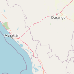
Map view of Meseta de Cacaxtla Flora and Fauna Protection Area

Use this park location map to pinpoint Meseta de Cacaxtla Flora and Fauna Protection Area in Mexico, understand its exact geographic position, and read its mapped placement within the surrounding landscape more clearly.

Pigeon | © OpenStreetMap contributors

Location context for Meseta de Cacaxtla Flora and Fauna Protection Area

Sinaloa
Park atlas

Compare adjacent coastal ecosystems, dry forests, and neighboring protected areas across western Mexico.

Parks Near Meseta de Cacaxtla Flora and Fauna Protection Area and Regional Protected Landscapes

Browsing nearby national parks and protected areas provides broader geographic context for the surrounding regional terrain. Comparing these adjacent habitats helps trace regional conservation networks beyond individual reserve boundaries.
Regional parkSinaloa
About 44 km away#1 closest

Northwest

Ceuta Regional Park: Coastal Geography and Protected Nesting Habitats in Sinaloa

Coastal protection and agricultural valley landscape analysis.

Ceuta Regional Park stands as a key protected area on the Sinaloa coast of Mexico, noted for its long-standing sea turtle conservation initiatives and importance to migratory shorebirds. The park geography spans low-lying coastal plains and beach environments, framed by the agricultural heart of the Elota municipality. This entry provides a structural overview of the terrain, boundaries, and ecological context defining this coastal reserve.

Area
15 km²
Established
2002
Relief
Lowland
Access
Access unknown
National parkNayarit
About 208 km away#2 closest

South

Isla Isabel National Park: Protected Island Landscape within Nayarit's Geography

Explore its mapped boundaries and distinct geography.

Isla Isabel National Park represents a crucial protected area within the broader geographic framework of Nayarit. This national park offers a focused lens for exploring a unique island landscape, its specific mapped boundaries, and its place within the regional atlas. Understanding its ecological and geographic context is key to appreciating this distinct natural landscape.

Area
1.94 km²
Established
1980
IUCN
II
Biosphere reserveNayarit
About 236 km away#3 closest

South

Islas Marías Biosphere Reserve: Geographic Overview and Protected Island Mapping

Volcanic topography and marine ecosystems in the Pacific.

The Islas Marías archipelago represents a significant protected area within the Mexican Pacific. Defined by its four major islands and diverse volcanic terrain, the reserve supports unique endemic species and expansive marine ecosystems. This overview tracks the geographic boundaries, island profiles, and the ecological importance of this remote Pacific territory offshore from the state of Nayarit.

Area
244.97 km²
Established
2010
Relief
Upland
Climate
Subtropical
A soft watercolor illustration of rolling green hills, distant purple mountains, and stylized trees.
Protected areaChihuahua
About 264 km away#4 closest

North

Cerro Mohinora: Protected Volcanic Summit and Alpine Geography in Chihuahua

An analysis of volcanic terrain and high-elevation protected ecosystems.

Cerro Mohinora dominates the skyline as a prominent volcanic landmark within the Sierra Madre Occidental. This record details the protected area's geographic reach, examining its complex igneous history and the dramatic vertical transition from pine-covered slopes to its snowy summit, offering a clear map-oriented view of this significant Chihuahua natural landmark.

Established
2012
Relief
Mountain
Water
Minor water
Season
Seasonal
National parkBaja California Sur
About 283 km away#5 closest

West

Cabo Pulmo National Park: National Park Atlas and Protected Landscape Discovery

Explore its mapped geographic boundaries and regional context.

Cabo Pulmo National Park represents a vital protected natural landscape offering unique atlas exploration opportunities. Understand its specific geographic placement within Baja California Sur and explore its mapped boundaries as a national park. This destination provides a focused look at protected natural areas and their significance in regional geography.

Area
71.11 km²
Established
1995
IUCN
II
Relief
Lowland
Biosphere reserveNayarit
About 293 km away#6 closest

Southeast

Sierra de San Juan Biosphere Reserve: Geographic Overview and Protected Area Mapping

Volcanic terrain and forest ecosystems in Nayarit, Mexico

Explore the volcanic landforms and layered forest communities of Sierra de San Juan Biosphere Reserve. This protected area in Nayarit spans distinct ecological zones from dry coastal lowlands to mountain cloud forests, providing essential habitat and unique biodiversity at the convergence of major Mexican mountain systems.

Area
198.01 km²
Established
2003
Relief
Mountain
Scope
Terrestrial
National parkSombrerete Municipality
About 296 km away#7 closest

East

Sierra de Órganos National Park National Park: Mapped Protected Landscape Details

Explore geographic context and park boundaries within Sombrerete Municipality.

Sierra de Órganos National Park stands as a vital national park, offering a unique opportunity for geographic and atlas-based discovery. This dedicated entry focuses on its protected landscape identity, providing detailed insights into its mapped boundaries and its place within the regional geography of Sombrerete Municipality. Understand the park's role as a protected natural area through structured data and landscape context, essential for comprehensive geographic exploration.

Area
11.25 km²
Established
2000
IUCN
II
Relief
Mountain
Protected areaMexico
About 298 km away#8 closest

Southeast

Cuenca Alimentadora del Distrito Nacional de Riego 043 Estado de Nayarit: Atlas Overview

Watershed reserve and montane forest geography

This extensive protected area spans the Sierra Madre Occidental, featuring a fragmented landscape of high mountain ridges separated by river valleys. It safeguards critical pine and oak forest ecosystems that supply the Irrigation District 043, serving as a vital natural resource hub in west-central Mexico.

Area
23,290.3 km²
Established
1949
IUCN
VI
Relief
Mountain

Common questions about visiting, size, designation, and location context for Meseta de Cacaxtla Flora and Fauna Protection Area

Meseta de Cacaxtla Flora and Fauna Protection Area FAQs for park facts, access, geography, and protected area context

Find quick answers about Meseta de Cacaxtla Flora and Fauna Protection Area, including protected-area facts, park geography, trail and visitor context, and how the park fits into its surrounding country and regional landscape.
MoriAtlas Explorer

Continue Your Protected Areas Search Across the Global Atlas

Deepen your exploration by continuing the structured search for national parks and protected areas worldwide. Utilize the comprehensive filtering capabilities to compare different conservation landscapes and refine your understanding of global park geography. Discover more about the distribution and characteristics of protected natural areas.

Global natural geography