
Streams
Park geography
Regional context, boundary measurements, and environmental features for this arid protected area
Geographic Profile and Landscape Boundaries of Millstream Chichester National Park
This geographic profile details the physical extent of Millstream Chichester National Park in Western Australia. Examine the recorded boundary dimensions, terrain characteristics including the Fortescue River and surrounding peaks, and the arid environmental landscape. The data provides a structured view of the park area across its regional location.
Related tags
riparian ecosystemsPilbara landscapeIndigenous heritagepermanent waterholessandstone ranges
Ancient serpent country where permanent waterholes meet the Pilbara range
Millstream Chichester National Park
Millstream Chichester National Park is a vast protected area in the Pilbara region of Western Australia, spanning approximately 2,381 square kilometres of rugged terrain about 1,190 kilometres north of Perth. The park encompasses the historic Millstream Station on Millstream Creek, where the creek joins the Fortescue River one of the few permanent watercourses in this arid landscape. The park also protects the Chichester Range, a dramatic upland area that rises sharply from the surrounding plains. This combination of permanent waterholes, riparian corridors, and mountainous terrain creates a surprising oasis of biodiversity in what is otherwise an intensely dry region. The area holds profound cultural significance as the homeland of the Yinjibarndi people, whose connection to this landscape extends back thousands of years and is deeply intertwined with the mythology of the serpent being Warlu.
- Location
- Australia
- Park type
- National park
- Established
- 1970
- Area
- 2,381.7 km²
Location overview
Terrestrial park positioning and regional placement in Australia
Millstream Chichester National Park Geography in Western Australia
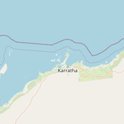
Millstream Chichester National Park is positioned within the regional borders of Western Australia. Official geographic records classify the park as an inland terrestrial area with no marine or transboundary zones.
- Countries
- Australia
- Regions
- Western Australia
- Primary location
- Western Australia
- Geographic setting
- Inland
Boundary and coordinates
Mapped protected geometry and derived geographic area measurements
Millstream Chichester National Park Boundary Map and Spatial Extent
Spatial outline mapping provides clear visual context for the designated park boundaries. Analytical measurements detail the recorded area across coordinate spans and centre limits.
- Boundary area
- 2,383.4 km²
- Boundary perimeter
- 745.1 km
- Northernmost point
- 21.1626° S
- Southernmost point
- 21.6324° S
- Easternmost point
- 117.7967° E
- Westernmost point
- 117.0013° E
- Geographic centre
- 21.4166° S, 117.3514° E
- North–south span
- 52 km
- East–west span
- 82.5 km
Terrain and natural features
Explore recorded peaks, rivers, streams, and viewpoints within the park
Millstream Chichester National Park Terrain and Named Natural Features
Mixed relief and mountain classifications define the terrain across Millstream Chichester National Park alongside numerous recorded natural features. Individual cards supply names, types, and spatial relationships for each mapped geographic entity.
Selected named natural features
Streams
Coorbeelie River
Peaks
Mount Herbert
Viewpoints
Panorama Lookout
Viewpoints
Cameleers Lookout
Rivers
Fish Creek
Environmental setting
Arid climate zones, mixed relief, and riverine habitats across the protected terrain
Millstream Chichester National Park Environmental and Landscape Classifications
Stored classifications organize the physical setting into broader interpretive categories across mountains, valleys, and river networks. Recorded attributes link directly to related atlas destinations where available.
- Relief
- Mixed relief
- Climate
- Arid
- Water
- Minor water
- Seasonality
- Year-round
Landscape features
Mountains · Valleys · Rivers
Habitat types
Riverine habitat · Grassland
Park atlas
Compare the Pilbara's diverse protected landscapes and find other national parks in Western Australia
Discover Related National Parks and Protected Areas Near Millstream Chichester National Park
Continue your exploration of the Pilbara region's unique protected areas by comparing national parks and reserves located near Millstream Chichester National Park. This geographic overview helps you trace riverine oases, sandstone ranges, and Indigenous heritage sites across Western Australia's vast landscapes, offering deeper context for the region's conservation efforts.
National parkPilbara
60 km away#1 closest
North

Murujuga National Park: Pilbara Region's Protected Natural Landscape
Explore mapped park boundaries and regional geography.
Murujuga National Park represents a vital protected territory within the Pilbara region of Australia. This page provides focused atlas information on the park's geographic scope, mapped terrain, and its significance as a national park. Understand the unique landscape context of Murujuga National Park and its place within the broader regional geography, offering detailed insights for geographic exploration.
- Area
- 48.51 km²
- Established
- 2013
- Climate
- Arid
- Access
- Moderate access
Marine protected areaWestern Australia
68 km away#2 closest
North
Dampier Marine Park: Geographic Overview and Marine Protected Area Mapping
Protected shelf ecosystems of the Pilbara coast, Western Australia
Dampier Marine Park spans a mosaic of shallow shelf waters near the Dampier Archipelago. This protected area integrates diverse management zones to support migratory pathways for marine megafauna and preserve benthic habitats across the Northwest Shelf Province. Understanding its boundaries provides insight into the intersection of conservation and marine spatial planning in one of Australia's most significant coastal bioregions.
- Area
- 1,252 km²
- Established
- 2018
- IUCN
- VI
- Relief
- Lowland
National parkWestern Australia
70 km away#3 closest
Southeast
Karijini National Park: Explore the Protected Landscape and Geographic Context in Western Australia
Mapped natural terrain and regional geography for this Australian national park.
Karijini National Park is a designated national park in Western Australia, offering a distinct protected landscape for geographic exploration. This detailed entry provides context on its specific location within the state, its mapped boundaries, and the surrounding natural terrain. It serves as a foundational element for understanding the park's role within the larger atlas of protected areas and natural geography across Australia.
- Area
- 6,274.22 km²
- Established
- 1969
- IUCN
- II
- Visitors
- 166K annual
Marine protected areaWestern Australia
156 km away#4 closest
Northwest
Montebello Islands Marine Park: Western Australia Marine Protected Area Atlas
Mapping tropical reefs and archipelago terrain
Montebello Islands Marine Park preserves a significant archipelago and its surrounding tropical marine environment off the Pilbara coast. The area features extensive reef flats, mangrove communities, and deep oceanic waters that provide essential habitat for marine life and nesting sea turtles. Its physical profile includes a unique mix of natural reef-building processes and human history, making it a key component of the Western Australian marine conservation landscape.
- Area
- 583.44 km²
- Established
- 2004
- IUCN
- II
- Relief
- Lowland
Marine protected areaWestern Australia
288 km away#5 closest
Southwest
Ningaloo Marine Park: Mapping Western Australia's Protected Marine Geography and Habitats
Examining the oceanic shelf and reef environments of this key marine protected area
Ningaloo Marine Park safeguards a dynamic mosaic of shallow lagoons, reef edges, and deeper slope environments off the coast of Western Australia. This protected expanse is central to the regional conservation of whale shark feeding grounds and humpback whale migratory routes, offering a detailed perspective on the geomorphological character of the Central Western Shelf Transition.
- Area
- 2,435 km²
- Established
- 1987
- IUCN
- IV
- Relief
- Lowland
National parkWestern Australia
294 km away#6 closest
South
Mount Augustus National Park: Western Australia National Park & Protected Landscape
Explore its mapped terrain and regional geographic context.
Mount Augustus National Park represents a significant protected area within the diverse geography of Western Australia. This page serves as a portal to understanding its specific protected landscape characteristics and its contribution to the state's mapped natural areas. Users can explore the park's geographic identity, its defined boundaries, and its role within a broader atlas of protected lands, providing essential context for regional landscape discovery.
- Area
- 91.68 km²
- Established
- 1989
- IUCN
- III
- Relief
- Mountain
National parkWestern Australia
308 km away#7 closest
West
Cape Range National Park: Exploring Western Australia's Protected Landscape Identity
Mapped boundaries and regional geographic context.
Cape Range National Park is a vital protected area located in Western Australia, offering a distinct geographic profile for atlas exploration. This entry focuses on its identity as a national park, detailing its mapped landscape and regional context. Users can discover the park's place within the state's diverse terrain and understand its significance as a mapped conservation area, contributing to a structured understanding of Australia's protected lands.
- Area
- 476.55 km²
- Established
- 1965
- IUCN
- II
- Relief
- Highland
Marine protected areaWestern Australia
312 km away#8 closest
West
Gascoyne Marine Park: Protected Marine Geography and Seafloor Terrain Map
Marine protected area situated along the Western Australian coast
Gascoyne Marine Park encompasses a significant offshore region defined by its shallow continental shelf and varied seafloor structures. This protected marine area supports vital habitats for migratory species and contributes to the broader ecological network of the North-west Marine Parks system, offering a clear view of specialized aquatic environments through detailed mapping.
- Area
- 81,766 km²
- Established
- 2018
- IUCN
- IV
- Relief
- Lowland
MoriAtlas Explorer
Continue Exploring Millstream Chichester National Park's Geographic Context and Protected Boundaries
Deepen your understanding of Millstream Chichester National Park by examining its precise geographic placement and the extent of its protected landscape. This destination provides essential context for comprehending its role within Western Australia's broader natural and mapped terrain. Continue your atlas exploration to uncover the full geographic significance of this national park entity.
Browse next
Global natural geography
Explore related park routes
Explore MoriAtlas Global ParksBrowse All MoriAtlas ParksGlobal Park Map DiscoveryMoriAtlas: Browse All CountriesBrowse All MoriAtlas ContinentsNational Park Environment AtlasGrand Canyon National Park AtlasYellowstone National Park AtlasYosemite National Park Atlas and GeographySerengeti National Park AtlasGalápagos National Park Protected LandscapeBanff National Park Geography and AtlasKruger National Park Atlas EntryUluṟu-Kata Tjuṯa National Park AtlasExplore Uluru-Kata Tjuta National Park GeographyPlitvice Lakes National Park AtlasFiordland National Park Protected LandscapeGreat Smoky Mountains National Park AtlasAfghanistan National Parks and Protected AreasAlbania National Parks and Protected AreasAlgeria National Parks and Protected AreasAmerican Samoa National Parks and Protected AreasAndorra National Parks and Protected AreasAngola National Parks and Protected AreasAntarctica National Parks and Protected AreasAntigua and Barbuda Park List